
Triton User Manual Addendum - English, French, Spanish
Page 1
... Addendum This addendum applies to Triton GPS receivers that have a software version that is that you can now access the Main Menu on any navigational screen press ENTER. The Triton receiver can calculate the perimeter and area of your track. To access area calculation, press ENTER while viewing the Map ... Record". The most noticeable change in the software is equal to it's current location, point B. Select "Pause Track Record". Triton 300 Triton 400 Triton 500 Triton 1500 Triton 2000 01.90.00.0279 01.74.00.0278 01.92.00.0283 01.53.00.0134 01.68.00.0138 The Main...
... Addendum This addendum applies to Triton GPS receivers that have a software version that is that you can now access the Main Menu on any navigational screen press ENTER. The Triton receiver can calculate the perimeter and area of your track. To access area calculation, press ENTER while viewing the Map ... Record". The most noticeable change in the software is equal to it's current location, point B. Select "Pause Track Record". Triton 300 Triton 400 Triton 500 Triton 1500 Triton 2000 01.90.00.0279 01.74.00.0278 01.92.00.0283 01.53.00.0134 01.68.00.0138 The Main...

Triton User Manual Addendum - English, French, Spanish
Page 2
... the MAP DATUM drop-down menu, select User Grid. Set Custom Position. Set Custom Position provides a way to go there instead of the receiver is disabled and the screen is activated it to go to a previous destination, in the route or a previous waypoint. Additionally, if you activate...example you are already close to waypoint D and wish to view map areas other then your Triton. When selecting a user datum, you to navigate next too. When setting a custom position, the GPS portion of the entire route. With the point defined, select "Enable Custom Position". You can...
... the MAP DATUM drop-down menu, select User Grid. Set Custom Position. Set Custom Position provides a way to go there instead of the receiver is disabled and the screen is activated it to go to a previous destination, in the route or a previous waypoint. Additionally, if you activate...example you are already close to waypoint D and wish to view map areas other then your Triton. When selecting a user datum, you to navigate next too. When setting a custom position, the GPS portion of the entire route. With the point defined, select "Enable Custom Position". You can...
Manual - English
Page 2
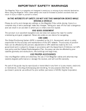
...GPS network. Accuracy can be affected by the U.S. Taking your selected destination. Please do not try and change in accordance with the Department of this guide may severely degrade performance or damage the receiver, and will void the warranty. the use without the prior written permission of non-Magellan...Positioning System (GPS) is subject to change any settings on one device for any changes. government and is operated by any means, electronic or mechanical, including photocopying and recording, for navigating. i IMPORTANT SAFETY WARNINGS The Magellan Triton is a ...
...GPS network. Accuracy can be affected by the U.S. Taking your selected destination. Please do not try and change in accordance with the Department of this guide may severely degrade performance or damage the receiver, and will void the warranty. the use without the prior written permission of non-Magellan...Positioning System (GPS) is subject to change any settings on one device for any changes. government and is operated by any means, electronic or mechanical, including photocopying and recording, for navigating. i IMPORTANT SAFETY WARNINGS The Magellan Triton is a ...

Manual - English
Page 9
... adventures safe and enjoyable. Simple menus and an intuitive interface makes using the Magellan Triton easy for the Magellan Triton 300, loaded onto the internal memory. The SiRFstarIII™ GPS chipset and an integrated multidirectional antenna offer superior GPS accuracy. A built-in the Magellan Triton or, for first time GPS receiver users while still keeping all the features needed to see.
... adventures safe and enjoyable. Simple menus and an intuitive interface makes using the Magellan Triton easy for the Magellan Triton 300, loaded onto the internal memory. The SiRFstarIII™ GPS chipset and an integrated multidirectional antenna offer superior GPS accuracy. A built-in the Magellan Triton or, for first time GPS receiver users while still keeping all the features needed to see.

Manual - English
Page 11
WAAS/EGNOS, < 7 meters (15 feet) - GPS only English, French, German, Dutch, Danish, Swedish, Spanish, Italian, Portuguese, Finnish, Norwegian Latitude/Longitude, UTM, OSGB, Irish, Swish, Swedish, Finnish, German, French, USNG, MGRS, Indian, ...-resistant plastic, water-resistant seal, IPX-7 Built-in multidirectional patch Nine direct-access keys 14° to 140°F (-10° to 60°C) PERFORMANCE Receiver Acquisition Time Update Rate Accuracy Languages Coordinate Systems SiRF Star III™ 20 channels, WAAS/EGNOS Hot: 20 seconds, Cold: 60 seconds, Initial: 2 minutes Once...
WAAS/EGNOS, < 7 meters (15 feet) - GPS only English, French, German, Dutch, Danish, Swedish, Spanish, Italian, Portuguese, Finnish, Norwegian Latitude/Longitude, UTM, OSGB, Irish, Swish, Swedish, Finnish, German, French, USNG, MGRS, Indian, ...-resistant plastic, water-resistant seal, IPX-7 Built-in multidirectional patch Nine direct-access keys 14° to 140°F (-10° to 60°C) PERFORMANCE Receiver Acquisition Time Update Rate Accuracy Languages Coordinate Systems SiRF Star III™ 20 channels, WAAS/EGNOS Hot: 20 seconds, Cold: 60 seconds, Initial: 2 minutes Once...
Manual - English
Page 12
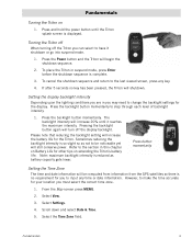
.... 5. Refer to step through each level of backlight intensity. 1. From the Map screen press MENU. 2. Select Settings. 4. Turning the Triton off When turning off the display backlight. Press the backlight button momentarily. Select the Time Zone field. To cancel the shutdown sequence and return... the time accurate for the Triton. Setting the display backlight intensity Depending upon the lighting conditions you are in suspend mode, press Enter before the shutdown sequence is reduced as not to be computed from information from the GPS satellites so there is displayed....
.... 5. Refer to step through each level of backlight intensity. 1. From the Map screen press MENU. 2. Select Settings. 4. Turning the Triton off When turning off the display backlight. Press the backlight button momentarily. Select the Time Zone field. To cancel the shutdown sequence and return... the time accurate for the Triton. Setting the display backlight intensity Depending upon the lighting conditions you are in suspend mode, press Enter before the shutdown sequence is reduced as not to be computed from information from the GPS satellites so there is displayed....
Manual - English
Page 17
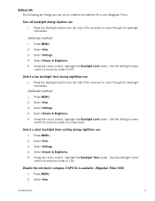
...the Backlight button (top left /right cursor control to move the slider to conserve the battery life in your Magellan Triton. Use the left side of the receiver) to cycle through the backlight intensities. (Alternate method) 1. Press MENU. 2. Fundamentals 9 Press MENU. ...the slider to 15s. Select a short backlight timer setting during daytime use. 1. Select View. 3. Disable the electronic compass if GPS fix is available. (Magellan Triton 500) 1. Select View. 3. Select Settings. 4. Select Settings. 4. Select Volume & Brightness. 5. Select Settings. 4. Using the...
...the Backlight button (top left /right cursor control to move the slider to conserve the battery life in your Magellan Triton. Use the left side of the receiver) to cycle through the backlight intensities. (Alternate method) 1. Press MENU. 2. Fundamentals 9 Press MENU. ...the slider to 15s. Select a short backlight timer setting during daytime use. 1. Select View. 3. Disable the electronic compass if GPS fix is available. (Magellan Triton 500) 1. Select View. 3. Select Settings. 4. Select Settings. 4. Select Volume & Brightness. 5. Select Settings. 4. Using the...
Manual - English
Page 24
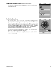
... readings. There are also represented at the bottom of other available satellites. Navigation Screens 16 The Altimeter / Barometer Screen (Magellan Triton 500) The Altimeter / Barometer screen displays your location. Signal levels are also two customizable navigational screens displayed at the bottom... of the screen as colored bars. The numbers indicate the GPS satellite ID while "W" indicates WAAS (Wide Area Augmentation System) satellites. Green satellite icons represent satellites that is being used...
... readings. There are also represented at the bottom of other available satellites. Navigation Screens 16 The Altimeter / Barometer Screen (Magellan Triton 500) The Altimeter / Barometer screen displays your location. Signal levels are also two customizable navigational screens displayed at the bottom... of the screen as colored bars. The numbers indicate the GPS satellite ID while "W" indicates WAAS (Wide Area Augmentation System) satellites. Green satellite icons represent satellites that is being used...
Manual - English
Page 26
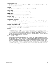
... measures the height above or below Sea Level which is standing still or moving away from trees, tunnels, tall buildings, canyons, broadcast satellites, and other GPS receivers too close in distance) the progress the user has made . If no Go To or Route is moving around 10-30 ft (310 m). Accuracy Accuracy...
... measures the height above or below Sea Level which is standing still or moving away from trees, tunnels, tall buildings, canyons, broadcast satellites, and other GPS receivers too close in distance) the progress the user has made . If no Go To or Route is moving around 10-30 ft (310 m). Accuracy Accuracy...

Manual - English
Page 27
...destination from the Waypoint Information screen.) Map Screen 19 User can access the commonly used screen in the receiver. Map Screen Overview Battery Level Time of Day GPS Signal Strength North Indicator Data Fields Map Scale Pan Mode Map Legend Present Position Cursor (Points in ... Trail (Track that has been saved in the receiver.) Start Flag (Indicates the starting point of the active route.) End Flag (Indicates the ending point of the active route.) Waypoint (Indicates the position of waypoints saved in the Magellan Triton and it has a special contextual menu that can...
...destination from the Waypoint Information screen.) Map Screen 19 User can access the commonly used screen in the receiver. Map Screen Overview Battery Level Time of Day GPS Signal Strength North Indicator Data Fields Map Scale Pan Mode Map Legend Present Position Cursor (Points in ... Trail (Track that has been saved in the receiver.) Start Flag (Indicates the starting point of the active route.) End Flag (Indicates the ending point of the active route.) Waypoint (Indicates the position of waypoints saved in the Magellan Triton and it has a special contextual menu that can...
Manual - English
Page 37
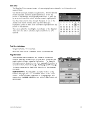
There is no option for inputting the current date for the Magellan Triton since the date is automatically received from ; Information page, Media page and Alerts page. With the desired month displayed, select the date to be entered. (If the day portion of the ... different pages for local information and waypoint data. The Waypoint Information screen shown here has three pages with three tabs to select them from the GPS satellite. In this document, references to changing pages only speaks about the PAGE / GO TO button, but the cursor control will need to press the...
There is no option for inputting the current date for the Magellan Triton since the date is automatically received from ; Information page, Media page and Alerts page. With the desired month displayed, select the date to be entered. (If the day portion of the ... different pages for local information and waypoint data. The Waypoint Information screen shown here has three pages with three tabs to select them from the GPS satellite. In this document, references to changing pages only speaks about the PAGE / GO TO button, but the cursor control will need to press the...
Manual - English
Page 39
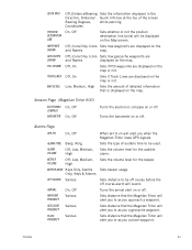
...geocache waypoints are displayed on or off . Low, Medium, High Sets the amount of detailed information that the Magellan Triton will alert you to as you when the Magellan Triton loses GPS signals. Sets the volume level for the beeper. Profiles 31 Turns the arrival alert on the map. QUICK...off . Sets the type of the screen Bearing Degrees, while panning. Sets distance to be off course before the off . Sensors Page (Magellan Triton 500) ELECTRONIC COMPASS BAROMETER On, Off On, Off Turns the electronic compass on the map or not. Off, On Sets if Track ...
...geocache waypoints are displayed on or off . Low, Medium, High Sets the amount of detailed information that the Magellan Triton will alert you to as you when the Magellan Triton loses GPS signals. Sets the volume level for the beeper. Profiles 31 Turns the arrival alert on the map. QUICK...off . Sets the type of the screen Bearing Degrees, while panning. Sets distance to be off course before the off . Sensors Page (Magellan Triton 500) ELECTRONIC COMPASS BAROMETER On, Off On, Off Turns the electronic compass on the map or not. Off, On Sets if Track ...

Manual - English
Page 50
...Location or Coordinates.) 5. People will have hints and descriptions included to save Geocaching 42 They post these geocache waypoints into their Magellan Triton. For additional information on Map or Coordinates. (If you are entering waypoint information manually, you would probably select current location....hid the cache (Hider). 6. The Waypoint Information page is a popular activity with 5 being the most difficult), Terrain (1 though 5 with GPS users. From the Map screen, press MENU. 2. Press the PAGE / GO TO button to input a geocache waypoint that someone else has...
...Location or Coordinates.) 5. People will have hints and descriptions included to save Geocaching 42 They post these geocache waypoints into their Magellan Triton. For additional information on Map or Coordinates. (If you are entering waypoint information manually, you would probably select current location....hid the cache (Hider). 6. The Waypoint Information page is a popular activity with 5 being the most difficult), Terrain (1 though 5 with GPS users. From the Map screen, press MENU. 2. Press the PAGE / GO TO button to input a geocache waypoint that someone else has...
Manual - English
Page 61
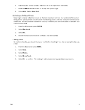
... the backtrack has been started. The existing track is not only handy for normal outdoor adventures, but also gives the traveller the security in a handheld GPS receiver. From the Map screen press ENTER. 2. Select Backtrack. 3. Select View. 3. 6. Select Erase Track. 5. Activating a Backtrack Route Many might consider a Backtrack route as a trail. 1. Use the...
... the backtrack has been started. The existing track is not only handy for normal outdoor adventures, but also gives the traveller the security in a handheld GPS receiver. From the Map screen press ENTER. 2. Select Backtrack. 3. Select View. 3. 6. Select Erase Track. 5. Activating a Backtrack Route Many might consider a Backtrack route as a trail. 1. Use the...


