
Triton User Manual Addendum - English, French, Spanish
Page 1
...ones listed. In this software update you can pause and then resume recording your Triton. To access area calculation, press ENTER while viewing the Map screen. Pause and Resume Active Track. From any navigational screen press ENTER. Triton 300 Triton 400 Triton 500 Triton 1500 Triton 2000 01.90.00.0279...or a saved track or route) and computes the values for your track. When you are done. Triton User Manual Addendum This addendum applies to Triton GPS receivers that have a software version that you can now access the Main Menu on any of the Navigational screens brings up the ...
...ones listed. In this software update you can pause and then resume recording your Triton. To access area calculation, press ENTER while viewing the Map screen. Pause and Resume Active Track. From any navigational screen press ENTER. Triton 300 Triton 400 Triton 500 Triton 1500 Triton 2000 01.90.00.0279...or a saved track or route) and computes the values for your track. When you are done. Triton User Manual Addendum This addendum applies to Triton GPS receivers that have a software version that you can now access the Main Menu on any of the Navigational screens brings up the ...
Manual - English
Page 7
... 39 Setting Volume and Brightness 39 View Memory Usage 39 Clearing Memory 40 Restoring Factory Settings 40 Setting Connectivity 40 Getting Software Version Information 41 Viewing Copyright Information 41 Personalizing Magellan Triton 41 Performing Diagnostic Checks 41 Geocache Waypoints ...43 Creating a Geocache Waypoint 43 Editing a Saved Geocache Waypoint 43 Deleting a Saved Geocache Waypoint... To Routes ...46 Creating a Go To Route Using the Pan Cursor 46 Creating a Go To Route to a Saved User-Created Waypoint 46 Table of Contents Magellan Triton 3
... 39 Setting Volume and Brightness 39 View Memory Usage 39 Clearing Memory 40 Restoring Factory Settings 40 Setting Connectivity 40 Getting Software Version Information 41 Viewing Copyright Information 41 Personalizing Magellan Triton 41 Performing Diagnostic Checks 41 Geocache Waypoints ...43 Creating a Geocache Waypoint 43 Editing a Saved Geocache Waypoint 43 Deleting a Saved Geocache Waypoint... To Routes ...46 Creating a Go To Route Using the Pan Cursor 46 Creating a Go To Route to a Saved User-Created Waypoint 46 Table of Contents Magellan Triton 3
Manual - English
Page 9
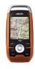
...the outdoor enthusiast with a powerful LED flashlight. Be sure to register your Magellan Triton at www.magellangps.com/support/ and select your Magellan Triton model for additional information and tips on the use of possible software updates and new features as you navigate and attach them to waypoints, ... pictures or videos of your adventure as they become available. Simple menus and an intuitive interface makes using the Magellan Triton easy for first time GPS receiver users while still keeping all the features needed to be installed in base map of the continental United States and...
...the outdoor enthusiast with a powerful LED flashlight. Be sure to register your Magellan Triton at www.magellangps.com/support/ and select your Magellan Triton model for additional information and tips on the use of possible software updates and new features as you navigate and attach them to waypoints, ... pictures or videos of your adventure as they become available. Simple menus and an intuitive interface makes using the Magellan Triton easy for first time GPS receiver users while still keeping all the features needed to be installed in base map of the continental United States and...
Manual - English
Page 17
Select ENTER. 5. Customizing the Data Field for the Map Screen 1. The Triton will need to select the detailed map you want to use to display the information selected. A checkmark will be displayed in pale orange. 2. Select OK. ... purchased and downloaded from the list shown and press ENTER. 6. Press ESC when done. Select the data type desired from the Magellan Store and installed using the optional National Geographic software. From the Map screen, press MENU. 2. Select Maps. 4. Customizing the Data Field for the Large Data, Compass or Satellite Status Screen...
Select ENTER. 5. Customizing the Data Field for the Map Screen 1. The Triton will need to select the detailed map you want to use to display the information selected. A checkmark will be displayed in pale orange. 2. Select OK. ... purchased and downloaded from the list shown and press ENTER. 6. Press ESC when done. Select the data type desired from the Magellan Store and installed using the optional National Geographic software. From the Map screen, press MENU. 2. Select Maps. 4. Customizing the Data Field for the Large Data, Compass or Satellite Status Screen...
Manual - English
Page 49
From the Map screen press MENU. 2. Personalizing Magellan Triton 1. Select the green checkmark to the About Menu. From the Map screen press MENU. 2. Select View. 3. Select About. 5. Select Version. 6. Select View. 3. ...About. 5. Performing Diagnostic Checks 1. Settings 41 Press ESC to return to accept. 9. Select View. 3. Select Audio Test, Video Test, Keypad Test or Touch Test. Getting Software Version Information 1. From the Map screen press MENU. 2. Select View. 3. Select Settings. 4. Press ESC to return to change (Name, Address, Phone, or EMail). ...
From the Map screen press MENU. 2. Personalizing Magellan Triton 1. Select the green checkmark to the About Menu. From the Map screen press MENU. 2. Select View. 3. Select About. 5. Select Version. 6. Select View. 3. ...About. 5. Performing Diagnostic Checks 1. Settings 41 Press ESC to return to accept. 9. Select View. 3. Select Audio Test, Video Test, Keypad Test or Touch Test. Getting Software Version Information 1. From the Map screen press MENU. 2. Select View. 3. Select Settings. 4. Press ESC to return to change (Name, Address, Phone, or EMail). ...
Manual - English
Page 51
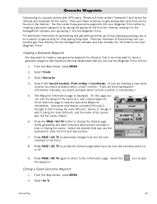
... display the Details page. Geocache information includes Difficulty (1 through 5 with 5 being the most difficult), Terrain (1 though 5 with GPS users. Select Go To. Geocache Waypoints Geocaching is displayed. People will have hints and descriptions included to input a geocache waypoint that...can turn the proximity alarm on geocaching for the cache. Select the desired field and use the Magellan Triton to the VantagePoint software and uploading it into their Magellan Triton. Some geocaches will hide caches ("treasures") and record the latitude and longitude for other geocaching ...
... display the Details page. Geocache information includes Difficulty (1 through 5 with 5 being the most difficult), Terrain (1 though 5 with GPS users. Select Go To. Geocache Waypoints Geocaching is displayed. People will have hints and descriptions included to input a geocache waypoint that...can turn the proximity alarm on geocaching for the cache. Select the desired field and use the Magellan Triton to the VantagePoint software and uploading it into their Magellan Triton. Some geocaches will hide caches ("treasures") and record the latitude and longitude for other geocaching ...
Manual - English
Page 63
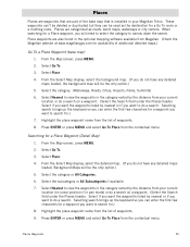
... background map. (If you will be the only option.) 5. Select Nearest to view the waypoints in the category sorted by the distance from Magellan. (Check the Magellan website at www.magellangps.com for .) 7. Searching for a Place waypoint, you do a search on a waypoint. (Select the Search field ... from the list of waypoints. 9. Select Go To. 3. Places Places are waypoints that is installed in your Magellan Triton. Places are also found in the optional mapping software available from your current location (or cursor position if in pan mode) or do not have any detailed maps ...
... background map. (If you will be the only option.) 5. Select Nearest to view the waypoints in the category sorted by the distance from Magellan. (Check the Magellan website at www.magellangps.com for .) 7. Searching for a Place waypoint, you do a search on a waypoint. (Select the Search field ... from the list of waypoints. 9. Select Go To. 3. Places Places are waypoints that is installed in your Magellan Triton. Places are also found in the optional mapping software available from your current location (or cursor position if in pan mode) or do not have any detailed maps ...
