User Manual
Page 2
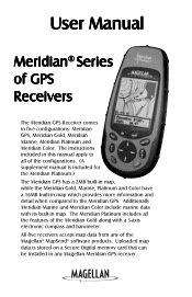
... a Secure Digital memory card that can be installed in map. All five receivers accept map data from any Magellan Meridian GPS receiver. User Manual Meridian® Series of GPS Receivers The Meridian GPS Receiver comes in map which provides more information and detail when compared to all the features of the Magellan® MapSend® software products. The instructions included in this manual apply to the Meridian GPS. Meridian Gold, Meridian Marine, Meridian Platinum and Meridian Color. Additionally Meridian Marine and Meridian Color include marine data with its built...
... a Secure Digital memory card that can be installed in map. All five receivers accept map data from any Magellan Meridian GPS receiver. User Manual Meridian® Series of GPS Receivers The Meridian GPS Receiver comes in map which provides more information and detail when compared to all the features of the Magellan® MapSend® software products. The instructions included in this manual apply to the Meridian GPS. Meridian Gold, Meridian Marine, Meridian Platinum and Meridian Color. Additionally Meridian Marine and Meridian Color include marine data with its built...
User Manual
Page 3
... not use, copy, modify, reverse engineer or transfer this SOFTWARE except as expressly provided in this guide may be affected by the periodic adjustments to change any purpose other copyright material. Magellan and MapSend are reserved by Thales Navigation and/or its suppliers and is the property of Thales Navigation and/or its suppliers. * * * No part of Thales Navigation. © 2002 by United States...
... not use, copy, modify, reverse engineer or transfer this SOFTWARE except as expressly provided in this guide may be affected by the periodic adjustments to change any purpose other copyright material. Magellan and MapSend are reserved by Thales Navigation and/or its suppliers and is the property of Thales Navigation and/or its suppliers. * * * No part of Thales Navigation. © 2002 by United States...
User Manual
Page 6
... About This User Manual 1 Setting Up the Meridian Installing the Batteries 3 Initialization for First Time Use 4 Optional Setup Functions 7 Basic Operation Meridian GPS Receiver 8 Turning Power On/Off 9 Turning the Backlight On/Off 9 Adjusting the Contrast 10 Getting a Position Fix 10 Navigational Screens 10 Map Screen 11 Compass Screen 11 Large Data Screen 11 Position Screens 12 Road Screen 12 Data Screen 12 Speedometer Screen 12 Satellite Status Screen 12 Accessing the Navigation Screens 13 Saving a Waypoint 13 Using GOTO Routes 16 Creating a GOTO Route 16 Navigating on...
... About This User Manual 1 Setting Up the Meridian Installing the Batteries 3 Initialization for First Time Use 4 Optional Setup Functions 7 Basic Operation Meridian GPS Receiver 8 Turning Power On/Off 9 Turning the Backlight On/Off 9 Adjusting the Contrast 10 Getting a Position Fix 10 Navigational Screens 10 Map Screen 11 Compass Screen 11 Large Data Screen 11 Position Screens 12 Road Screen 12 Data Screen 12 Speedometer Screen 12 Satellite Status Screen 12 Accessing the Navigation Screens 13 Saving a Waypoint 13 Using GOTO Routes 16 Creating a GOTO Route 16 Navigating on...
User Manual
Page 7
... 27 Turning Map Info On/Off 27 Selecting the Map Information 27 Two Data Fields Description 27 Changing the Data Fields 29 Street Information Description 29 Horizontal Profile Description 29 Terrain Projection Description 31 Changing the Map Orientation 32 Selecting Primary Usage 32 Selecting Track Mode 32 Auto vs. Auto Detailed 33 Compass Screen 34 Customizing the Data Fields 35 Large Data Screen 35 Customizing the Data Fields 36 ii Magellan Meridian GPS Receiver
... 27 Turning Map Info On/Off 27 Selecting the Map Information 27 Two Data Fields Description 27 Changing the Data Fields 29 Street Information Description 29 Horizontal Profile Description 29 Terrain Projection Description 31 Changing the Map Orientation 32 Selecting Primary Usage 32 Selecting Track Mode 32 Auto vs. Auto Detailed 33 Compass Screen 34 Customizing the Data Fields 35 Large Data Screen 35 Customizing the Data Fields 36 ii Magellan Meridian GPS Receiver
User Manual
Page 9
... Meridian 59 Turning the NAV Screens On/Off 59 Selecting the Coordinate System 60 Selecting a Map Datum 60 Selecting the Elevation Mode 61 Selecting the Time Format 61 Selecting NAV Units 61 Selecting the North Reference 62 Selecting Daylight Savings 62 Power Off Timer 63 Setting the Backlight Timer 63 Turning the Beeper On/Off 64 Selecting NMEA Message 64 Selecting the Baud Rate 64 iv Magellan Meridian GPS Receiver
... Meridian 59 Turning the NAV Screens On/Off 59 Selecting the Coordinate System 60 Selecting a Map Datum 60 Selecting the Elevation Mode 61 Selecting the Time Format 61 Selecting NAV Units 61 Selecting the North Reference 62 Selecting Daylight Savings 62 Power Off Timer 63 Setting the Backlight Timer 63 Turning the Beeper On/Off 64 Selecting NMEA Message 64 Selecting the Baud Rate 64 iv Magellan Meridian GPS Receiver
User Manual
Page 10
.../Moon Position 67 Fish/Hunt Times Display 68 Accessing the Fish/Hunt Screen 68 Changing the Fish/Hunt Date 68 Changing the Fish/Hunt Position 68 Alarms 69 Setting the Arrival Alarm 69 Setting the Anchor Alarm 69 Setting the XTE Alarm 69 Setting the GPS Fix Alarm 69 Using the Simulator 70 Turning on the Simulator - Changing the Power Key Settings 65 Selecting Languages 65 Clearing Memory 66 Clearing Track History 66 Clearing Wpts/Routes 66 Clearing All Routes 66 Resetting Meridian to Memory Card 71 Save Track ...71 Loading Waypoints and Routes...
.../Moon Position 67 Fish/Hunt Times Display 68 Accessing the Fish/Hunt Screen 68 Changing the Fish/Hunt Date 68 Changing the Fish/Hunt Position 68 Alarms 69 Setting the Arrival Alarm 69 Setting the Anchor Alarm 69 Setting the XTE Alarm 69 Setting the GPS Fix Alarm 69 Using the Simulator 70 Turning on the Simulator - Changing the Power Key Settings 65 Selecting Languages 65 Clearing Memory 66 Clearing Track History 66 Clearing Wpts/Routes 66 Clearing All Routes 66 Resetting Meridian to Memory Card 71 Save Track ...71 Loading Waypoints and Routes...
User Manual
Page 12
... step-by -turn routing capabilities. Since that will want to use the Meridian for most things you will last you with outdoor recreational activities has come . This User Manual is a registered trademark name of the Meridian. Each of the Magellan Meridian GPS receiver. Setting Up the Meridian: This chapter will explain getting a position fix, viewing the Map screen, saving a waypoint and using the basic functions of Thales Navigation. Basic Operation: This...
... step-by -turn routing capabilities. Since that will want to use the Meridian for most things you will last you with outdoor recreational activities has come . This User Manual is a registered trademark name of the Meridian. Each of the Magellan Meridian GPS receiver. Setting Up the Meridian: This chapter will explain getting a position fix, viewing the Map screen, saving a waypoint and using the basic functions of Thales Navigation. Basic Operation: This...
User Manual
Page 13
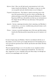
... are looking for all users. Experienced GPS users will find step-by mail. 2 Magellan Meridian GPS Receiver It's time to be familiar to all of the features found in this manual that they are looking for the beginning user as well as provide the experienced users with the size of the manual as we have tried to its fullest. Reference Guide: Here you will probably...
... are looking for all users. Experienced GPS users will find step-by mail. 2 Magellan Meridian GPS Receiver It's time to be familiar to all of the features found in this manual that they are looking for the beginning user as well as provide the experienced users with the size of the manual as we have tried to its fullest. Reference Guide: Here you will probably...
User Manual
Page 20
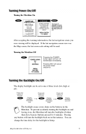
If the last navigation screen view was the Map screen, the last zoom scale setting will turn off the Meridian immediately. Turning the Meridian Off PWR Pressing the POWER button again will be used. To prevent accidently turning the backlight on and leaving it on, the Meridian will shut off. Magellan Meridian GPS Receiver 9 Tuning the Meridian On PWR ENTER You have 10 seconds to one of three levels (low, high or...
If the last navigation screen view was the Map screen, the last zoom scale setting will turn off the Meridian immediately. Turning the Meridian Off PWR Pressing the POWER button again will be used. To prevent accidently turning the backlight on and leaving it on, the Meridian will shut off. Magellan Meridian GPS Receiver 9 Tuning the Meridian On PWR ENTER You have 10 seconds to one of three levels (low, high or...

User Manual
Page 43
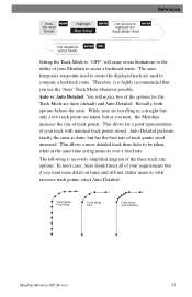
... map. In "Auto" or "Auto Detailed" mode, the Meridian uses a method for track point storage. 32 Magellan Meridian GPS Receiver The heading of the active leg of the active route is at the top of the screen. Setting the mode to select ENTER NAV the desired Map Orientation North Up Course Up Track Up North is at the top of the screen. For marine applications it may be set how often the Meridian stores track...
... map. In "Auto" or "Auto Detailed" mode, the Meridian uses a method for track point storage. 32 Magellan Meridian GPS Receiver The heading of the active leg of the active route is at the top of the screen. Setting the mode to select ENTER NAV the desired Map Orientation North Up Course Up Track Up North is at the top of the screen. For marine applications it may be set how often the Meridian stores track...
User Manual
Page 44
... time saving memory over a fixed rate. Reference From MENU the MAP Screen Highlight Map Setup ENTER Use arrows to ENTER highlight the "Track Mode" field Use arrows to ENTER NAV select Mode Setting the Track Mode to "OFF" will notice two of the options for a good representation of your track with excessive track points, select Auto Detailed. Basically, both options behave the same. Track Mode Fixed Rate Track Mode Auto Track Mode Auto Detailed Magellan Meridian GPS Receiver 33 The same temporary waypoints used to create the displayed track...
... time saving memory over a fixed rate. Reference From MENU the MAP Screen Highlight Map Setup ENTER Use arrows to ENTER highlight the "Track Mode" field Use arrows to ENTER NAV select Mode Setting the Track Mode to "OFF" will notice two of the options for a good representation of your track with excessive track points, select Auto Detailed. Basically, both options behave the same. Track Mode Fixed Rate Track Mode Auto Track Mode Auto Detailed Magellan Meridian GPS Receiver 33 The same temporary waypoints used to create the displayed track...
User Manual
Page 52
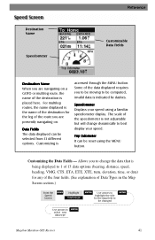
... is being displayed to 1 of 13 data options (bearing, distance, speed, heading, VMG, CTS, ETA, ETE, XTE, turn, elevation, time, or date) for any of the four fields. (See explanation of Data Types in the Map Screen section.) From the Speed Screen MENU Highlight Customize ENTER Use arrows to highlight the title for the leg of the route you are presently navigating on a GOTO or multileg route, the name...
... is being displayed to 1 of 13 data options (bearing, distance, speed, heading, VMG, CTS, ETA, ETE, XTE, turn, elevation, time, or date) for any of the four fields. (See explanation of Data Types in the Map Screen section.) From the Speed Screen MENU Highlight Customize ENTER Use arrows to highlight the title for the leg of the route you are presently navigating on a GOTO or multileg route, the name...
User Manual
Page 54
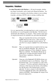
... very important that you have saved using the MARK function of the detailed map(s) you have uploaded a detailed map, you are included in the Meridian. You will notice a black line near the bottom of the database list with the detailed maps, a set of the uploaded map and press [ENTER]. Along with the name of the receiver. Reference Accessing Waypoints in the Database list. To...
... very important that you have saved using the MARK function of the detailed map(s) you have uploaded a detailed map, you are included in the Meridian. You will notice a black line near the bottom of the database list with the detailed maps, a set of the uploaded map and press [ENTER]. Along with the name of the receiver. Reference Accessing Waypoints in the Database list. To...
User Manual
Page 62
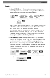
... Route List Highlight Activate Backtrk ENTER Magellan Meridian GPS Receiver 51 From Any Screen MENU Highlight Routes ENTER Select ENTER "Backtrack" from the waypoint database. You can select only those waypoints in alphabetical order (Alphabetical). You need do is gone. A good example of the waypoints in the category in your steps. From Any Screen GOTO If a GOTO route already exists, you will be if you need to clear it. Creates a route using track information...
... Route List Highlight Activate Backtrk ENTER Magellan Meridian GPS Receiver 51 From Any Screen MENU Highlight Routes ENTER Select ENTER "Backtrack" from the waypoint database. You can select only those waypoints in alphabetical order (Alphabetical). You need do is gone. A good example of the waypoints in the category in your steps. From Any Screen GOTO If a GOTO route already exists, you will be if you need to clear it. Creates a route using track information...
User Manual
Page 80
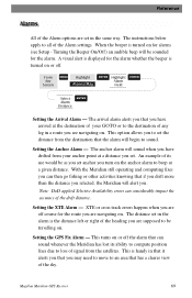
... you set in a route you are off course for the alarm whether the beeper is handy in the same way. From Any Screen MENU Highlight Alarms/Msg ENTER Highlight ENTER Alarm Field Select ENTER Alarm Distance Setting the Arrival Alarm - XTE or cross track errors happen when you are set . This turns on or off the alarm that has a clearer view of signal from the satellites. This is turned on or off . Magellan Meridian GPS Receiver 69...
... you set in a route you are off course for the alarm whether the beeper is handy in the same way. From Any Screen MENU Highlight Alarms/Msg ENTER Highlight ENTER Alarm Field Select ENTER Alarm Distance Setting the Arrival Alarm - XTE or cross track errors happen when you are set . This turns on or off the alarm that has a clearer view of signal from the satellites. This is turned on or off . Magellan Meridian GPS Receiver 69...
User Manual
Page 83
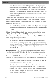
... Meridian and created a new route using the filenames that you provided when saving them. After accessing the Card Utilities menu, highlight "Test Card" and press [ENTER]. To begin the scan of saved tracks is lost clusters were recovered. One of the waypoint/route and track files that you have uploaded. This only displays how many were found on your SD card. Highlight the desired filename and press [ENTER]. You will replace...
... Meridian and created a new route using the filenames that you provided when saving them. After accessing the Card Utilities menu, highlight "Test Card" and press [ENTER]. To begin the scan of saved tracks is lost clusters were recovered. One of the waypoint/route and track files that you have uploaded. This only displays how many were found on your SD card. Highlight the desired filename and press [ENTER]. You will replace...

User Manual
Page 84
.... Magellan Meridian GPS Receiver 73 You will erase everything on the SD card, so continue only if you are not displayed using MapSend Streets™, and how much free memory is , the version and memory size of the base map, the number of and total memory size of tips available that there is no official additional base maps available for Nav Screens, Map, Routes, Setup, Database, User Waypoints and...
.... Magellan Meridian GPS Receiver 73 You will erase everything on the SD card, so continue only if you are not displayed using MapSend Streets™, and how much free memory is , the version and memory size of the base map, the number of and total memory size of tips available that there is no official additional base maps available for Nav Screens, Map, Routes, Setup, Database, User Waypoints and...
User Manual
Page 91
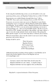
... problem, your name, address, a copy of your receiver and if calling, please have your receiver with your Meridian. With all correspondence, please state the model of your reasons to [email protected]. Customers outside of the United States should be sent to: Thales Navigation Magellan Products 960 Overland Court San Dimas, CA 91773 ATTN: Warranty/Repair Additional information regarding software updates to Customer Service...
... problem, your name, address, a copy of your receiver and if calling, please have your receiver with your Meridian. With all correspondence, please state the model of your reasons to [email protected]. Customers outside of the United States should be sent to: Thales Navigation Magellan Products 960 Overland Court San Dimas, CA 91773 ATTN: Warranty/Repair Additional information regarding software updates to Customer Service...

User Manual
Page 101
.... Appendix Connecting to an External Power Source If using the cable that comes with the cigarette lighter adapter, simply connect it to a power supply, cut the cable between the power supply box and the cigarette lighter adapter. The input voltage range for external power is the pinout looking into the 9-pin female connector Pin 2: Data Out Pin 3: Data In Pin 5: Ground 5 1 9 6 Cable Wiring Color Code Power Red: Power + Black: GND Data (Power/Data, PC cable & Data cable only) Yellow: Data In Orange: Data Out Black: GND 90 Magellan Meridian GPS Receiver
.... Appendix Connecting to an External Power Source If using the cable that comes with the cigarette lighter adapter, simply connect it to a power supply, cut the cable between the power supply box and the cigarette lighter adapter. The input voltage range for external power is the pinout looking into the 9-pin female connector Pin 2: Data Out Pin 3: Data In Pin 5: Ground 5 1 9 6 Cable Wiring Color Code Power Red: Power + Black: GND Data (Power/Data, PC cable & Data cable only) Yellow: Data In Orange: Data Out Black: GND 90 Magellan Meridian GPS Receiver
User Manual
Page 103
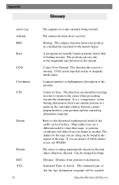
... surface. The value or setting automatically chosen by the unit unless otherwise directed. Estimated Time of the position. The current elevation above sea level. A navigation aid (usually found in water. Can be reported in Setup. Bearing. Course to destination. Distance from your position and the current leg destination waypoint. The position can be changed in true or magnetic north values. Refers to the nearest degree. The...
... surface. The value or setting automatically chosen by the unit unless otherwise directed. Estimated Time of the position. The current elevation above sea level. A navigation aid (usually found in water. Can be reported in Setup. Bearing. Course to destination. Distance from your position and the current leg destination waypoint. The position can be changed in true or magnetic north values. Refers to the nearest degree. The...

