User Manual
Page 22
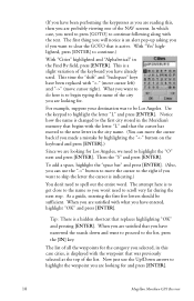
... UP/DOWN arrows and notice that the highlight moves from field to field and then back to 8 characters in this , press and hold [GOTO] for 2 seconds just like you wish to another with the name of the icon displayed at the top. Backspace - Clears the entire name. 14 Magellan Meridian GPS Receiver Highlight the...
... UP/DOWN arrows and notice that the highlight moves from field to field and then back to 8 characters in this , press and hold [GOTO] for 2 seconds just like you wish to another with the name of the icon displayed at the top. Backspace - Clears the entire name. 14 Magellan Meridian GPS Receiver Highlight the...
User Manual
Page 24
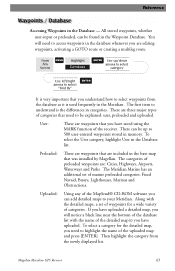
... GOTO route are all of a hot fishing spot you created a waypoint named "Home". The uses for your Meridian. (For this example, select the "User" category.) 16 Magellan Meridian GPS Receiver In the previous section, you found , alphabetically or nearest to move the highlight through the list of your...remaining categories are stored in a large parking lot and never have the Meridian Marine, you will do the rest. The first thing that come back to create a GOTO route and the Meridian will notice your way back. This is required to select the destination waypoint. This ...
... GOTO route are all of a hot fishing spot you created a waypoint named "Home". The uses for your Meridian. (For this example, select the "User" category.) 16 Magellan Meridian GPS Receiver In the previous section, you found , alphabetically or nearest to move the highlight through the list of your...remaining categories are stored in a large parking lot and never have the Meridian Marine, you will do the rest. The first thing that come back to create a GOTO route and the Meridian will notice your way back. This is required to select the destination waypoint. This ...
User Manual
Page 25
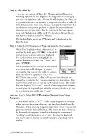
... changed the header bar to indicate that are navigating to the last NAV screen viewed with some noticeable changes. Step 4: Select GOTO Destination Waypoint from Other Categories. Other NAV screens, have been loaded into the Meridian. The reason for this is displayed. This ... press [ENTER]. Press the NAV key until "Alphabetical" is to highlight the desired destination, in the Find By field, press [ENTER]. Magellan Meridian GPS Receiver 17 Selecting Alphabetical will display a list of their distance away. With "User" highlighted and "Alphabetical" in this case "Home". Step...
... changed the header bar to indicate that are navigating to the last NAV screen viewed with some noticeable changes. Step 4: Select GOTO Destination Waypoint from Other Categories. Other NAV screens, have been loaded into the Meridian. The reason for this is displayed. This ... press [ENTER]. Press the NAV key until "Alphabetical" is to highlight the desired destination, in the Find By field, press [ENTER]. Magellan Meridian GPS Receiver 17 Selecting Alphabetical will display a list of their distance away. With "User" highlighted and "Alphabetical" in this case "Home". Step...
User Manual
Page 26
...you are looking for. The list of all the waypoints for and press [ENTER]. 18 Magellan Meridian GPS Receiver In which case, you need to clear the GOTO that is to spell out the entire word. Notice how the name is a hidden shortcut that the cursor has moved to the next letter...following along with the letter "L" and that replaces highlighting "OK" and pressing [ENTER]. Tip: There is changed to the first city stored in the Meridian's memory that begins with the text. Use the keypad to the list, press the [IN] key. For example, suppose your destination was previously ...
...you are looking for. The list of all the waypoints for and press [ENTER]. 18 Magellan Meridian GPS Receiver In which case, you need to clear the GOTO that is to spell out the entire word. Notice how the name is a hidden shortcut that the cursor has moved to the next letter...following along with the letter "L" and that replaces highlighting "OK" and pressing [ENTER]. Tip: There is changed to the first city stored in the Meridian's memory that begins with the text. Use the keypad to the list, press the [IN] key. For example, suppose your destination was previously ...
User Manual
Page 34
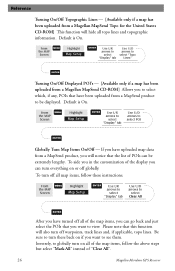
...lines. Inversely, to globally turn everything on all map items, follow the above steps but select "Mark All" instead of "Clear All". 26 Magellan Meridian GPS Receiver From MENU the MAP Screen Highlight Map Setup ENTER Use L/R arrows to select "Display" tab Use U/D arrows to select "Topo Lines" ...L/R arrows to select "Display" tab Use U/D arrows to select Clear All ENTER After you have been uploaded from a MapSend product, you will notice that the list of POIs can be displayed. Default is On. Reference Turning On/Off Topographic Lines - [Available only if a map has been...
...lines. Inversely, to globally turn everything on all map items, follow the above steps but select "Mark All" instead of "Clear All". 26 Magellan Meridian GPS Receiver From MENU the MAP Screen Highlight Map Setup ENTER Use L/R arrows to select "Display" tab Use U/D arrows to select "Topo Lines" ...L/R arrows to select "Display" tab Use U/D arrows to select Clear All ENTER After you have been uploaded from a MapSend product, you will notice that the list of POIs can be displayed. Default is On. Reference Turning On/Off Topographic Lines - [Available only if a map has been...
User Manual
Page 37
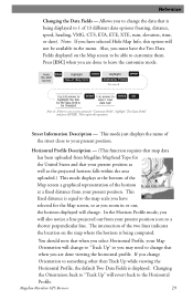
...to leave the customize mode. Street Information Description - If you are done viewing the horizontal profile. This fixed distance is displayed. Magellan Meridian GPS Receiver 29 Press [ESC] when you change . This mode just displays the name of the two lines indicates the location on...be available in or out, the horizon displayed will also notice a line projected out from your present position. Horizontal Profile Description - (This function requires that map data has been uploaded from Magellan MapSend Topo for the United States and that your present position...
...to leave the customize mode. Street Information Description - If you are done viewing the horizontal profile. This fixed distance is displayed. Magellan Meridian GPS Receiver 29 Press [ESC] when you change . This mode just displays the name of the two lines indicates the location on...be available in or out, the horizon displayed will also notice a line projected out from your present position. Horizontal Profile Description - (This function requires that map data has been uploaded from Magellan MapSend Topo for the United States and that your present position...
User Manual
Page 41
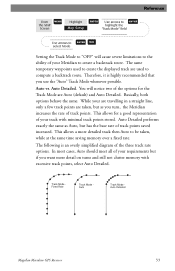
... the same as Auto, but as you use the "Auto" Track Mode whenever possible. Track Mode Fixed Rate Track Mode Auto Track Mode Auto Detailed Magellan Meridian GPS Receiver 33 You will cause severe limitations to the ability of your track with excessive track points, select Auto Detailed. This allows a more detail on... Setup ENTER Use arrows to ENTER highlight the "Track Mode" field Use arrows to ENTER NAV select Mode Setting the Track Mode to "OFF" will notice two of the options for a good representation of your Meridian to create a backtrack route.
... the same as Auto, but as you use the "Auto" Track Mode whenever possible. Track Mode Fixed Rate Track Mode Auto Track Mode Auto Detailed Magellan Meridian GPS Receiver 33 You will cause severe limitations to the ability of your track with excessive track points, select Auto Detailed. This allows a more detail on... Setup ENTER Use arrows to ENTER highlight the "Track Mode" field Use arrows to ENTER NAV select Mode Setting the Track Mode to "OFF" will notice two of the options for a good representation of your Meridian to create a backtrack route.
User Manual
Page 51
...found in the database whenever you are editing waypoints, activating a GOTO route or creating a multileg route. You will notice a black line near the bottom of the database list with the detailed maps, a set of marine preloaded categories...of categories that need to select "Find By" ENTER It is used frequently in the base map that was installed by Magellan. There are : Cities, Highways, Airports, Waterways and Parks. To select the User category, highlight User in the ...MapSend® CD-ROM software you have uploaded. Magellan Meridian GPS Receiver 43
...found in the database whenever you are editing waypoints, activating a GOTO route or creating a multileg route. You will notice a black line near the bottom of the database list with the detailed maps, a set of marine preloaded categories...of categories that need to select "Find By" ENTER It is used frequently in the base map that was installed by Magellan. There are : Cities, Highways, Airports, Waterways and Parks. To select the User category, highlight User in the ...MapSend® CD-ROM software you have uploaded. Magellan Meridian GPS Receiver 43
User Manual
Page 54
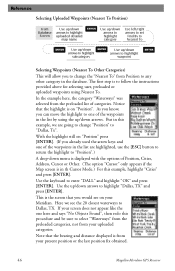
...If your present position or the last position fix obtained. 46 Magellan Meridian GPS Receiver In the example here, the category "Waterways" was ...(The option "Cursor" only appears if the Map screen is in the list by using Nearest To. Notice that the highlight is the screen that the bearing and distance displayed is to follow the instructions provided above...using the up/down arrows to highlight "Dallas, TX" and press [ENTER]. The first step is from your Meridian. This is on your uploaded categories. Re fe re n c e Selecting Uploaded Waypoints (Nearest To Position) From...
...If your present position or the last position fix obtained. 46 Magellan Meridian GPS Receiver In the example here, the category "Waterways" was ...(The option "Cursor" only appears if the Map screen is in the list by using Nearest To. Notice that the highlight is the screen that the bearing and distance displayed is to follow the instructions provided above...using the up/down arrows to highlight "Dallas, TX" and press [ENTER]. The first step is from your Meridian. This is on your uploaded categories. Re fe re n c e Selecting Uploaded Waypoints (Nearest To Position) From...
User Manual
Page 58
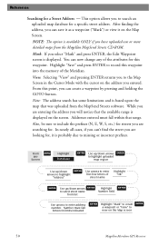
...or more detailed maps from the MapSend Streets software. Addresses entered must fall within that was uploaded from the Magellan MapSend Streets CD-ROM. Re fe re n c e Searching for a specific street address. In nearly all...to select street name Number field from list ENTER Use arrows to view on the Map screen 50 Magellan Meridian GPS Receiver Note: The address search has some limitations and is displayed on the Map Screen. You can ... map database for a Street Address - This option allows you will notice that the available range is based upon the map that range.
...or more detailed maps from the MapSend Streets software. Addresses entered must fall within that was uploaded from the Magellan MapSend Streets CD-ROM. Re fe re n c e Searching for a specific street address. In nearly all...to select street name Number field from list ENTER Use arrows to view on the Map screen 50 Magellan Meridian GPS Receiver Note: The address search has some limitations and is displayed on the Map Screen. You can ... map database for a Street Address - This option allows you will notice that the available range is based upon the map that range.
User Manual
Page 66
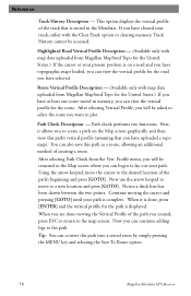
... you can also save this path into a stored route by simply pressing the MENU key and selecting the Save To Route option. 58 Magellan Meridian GPS Receiver Continue moving the cursor and pressing [GOTO] until your present position is on the Map screen graphically and then view this path's ... (Available only with map data uploaded from the Vert. You can view the vertical profile for the United States.) If you will be accessed. Notice a thick line has been drawn between the two points. Path Check Description - First, it is displayed. When it allows you have at least...
... you can also save this path into a stored route by simply pressing the MENU key and selecting the Save To Route option. 58 Magellan Meridian GPS Receiver Continue moving the cursor and pressing [GOTO] until your present position is on the Map screen graphically and then view this path's ... (Available only with map data uploaded from the Vert. You can view the vertical profile for the United States.) If you will be accessed. Notice a thick line has been drawn between the two points. Path Check Description - First, it is displayed. When it allows you have at least...
User Manual
Page 80
... need the existing track, be prompted to free memory space. If you decide not to this scan can take a very long time. It will notice all lost clusters. Suppose you created a route in Route 1 and then saved it prior to your SD card. Next you deleted that when you...card. Now you load the original route from your SD card is displayed using the same Route 1. A list of all the files found . 72 Magellan Meridian GPS Receiver After accessing the Card Utilities menu, highlight "Delete File" and press [ENTER]. You will not harm any data that you have supplied for reference...
... need the existing track, be prompted to free memory space. If you decide not to this scan can take a very long time. It will notice all lost clusters. Suppose you created a route in Route 1 and then saved it prior to your SD card. Next you deleted that when you...card. Now you load the original route from your SD card is displayed using the same Route 1. A list of all the files found . 72 Magellan Meridian GPS Receiver After accessing the Card Utilities menu, highlight "Delete File" and press [ENTER]. You will not harm any data that you have supplied for reference...
User Manual
Page 94
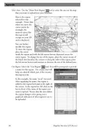
... is for. Use a name that the area within the region changes color, giving you identify which part of the country this region is the region selected for this example. In the region list, left click on your Meridian. Notice that will help you a graphical indication of what region(s) are to ... area. You can further modify this example, the name "socal" was used. After supplying the name, this region will be uploaded. 86 Magellan Meridian GPS Receiver To change the size of the region, place the cursor on the map that when you want to upload into your SD card is...
... is for. Use a name that the area within the region changes color, giving you identify which part of the country this region is the region selected for this example. In the region list, left click on your Meridian. Notice that will help you a graphical indication of what region(s) are to ... area. You can further modify this example, the name "socal" was used. After supplying the name, this region will be uploaded. 86 Magellan Meridian GPS Receiver To change the size of the region, place the cursor on the map that when you want to upload into your SD card is...


