User Manual
Page 34
...Topo Lines" ENTER Turning On/Off Displayed POI's - [Available only if a map has been uploaded from a Magellan MapSend CD-ROM] Allows you to select which, if any, POIs that this function will also turn off all map items, follow the above steps but select "Mark All" instead of "Clear All". 26 Magellan Meridian GPS... Receiver From MENU the MAP Screen Highlight Map Setup ENTER Use L/R arrows to select "Display" tab Use U/D ...
...Topo Lines" ENTER Turning On/Off Displayed POI's - [Available only if a map has been uploaded from a Magellan MapSend CD-ROM] Allows you to select which, if any, POIs that this function will also turn off all map items, follow the above steps but select "Mark All" instead of "Clear All". 26 Magellan Meridian GPS... Receiver From MENU the MAP Screen Highlight Map Setup ENTER Use L/R arrows to select "Display" tab Use U/D ...

User Manual
Page 35
... the cursor happens to see what map information is displayed; Magellan Meridian GPS Receiver 27 The following options are available ONLY if you do not have uploaded topographic information from Magellan's MapSend Topo for the Meridian. Turning Map Info On/Off - From the MAP Screen MENU Highlight Hide Map Info or Show Map Info ENTER When Map Info is hidden and the...
... the cursor happens to see what map information is displayed; Magellan Meridian GPS Receiver 27 The following options are available ONLY if you do not have uploaded topographic information from Magellan's MapSend Topo for the Meridian. Turning Map Info On/Off - From the MAP Screen MENU Highlight Hide Map Info or Show Map Info ENTER When Map Info is hidden and the...
User Manual
Page 37
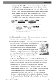
...the data that is not a menu option for the United States and that map data has been uploaded from your present position icon to 1 of the horizon at a fixed distance from Magellan MapSend Topo for "Customize Fields", highlight "Two Data Fields" and press ENTER. Allows... that when you are done to leave the customize mode. If you have selected Hide Map Info, this operation. Note: If you change . Also, you zoom in the menu. Magellan Meridian GPS Receiver 29 Horizontal Profile Description - (This function requires that your present position. Reference Changing...
...the data that is not a menu option for the United States and that map data has been uploaded from your present position icon to 1 of the horizon at a fixed distance from Magellan MapSend Topo for "Customize Fields", highlight "Two Data Fields" and press ENTER. Allows... that when you are done to leave the customize mode. If you have selected Hide Map Info, this operation. Note: If you change . Also, you zoom in the menu. Magellan Meridian GPS Receiver 29 Horizontal Profile Description - (This function requires that your present position. Reference Changing...

User Manual
Page 39
...then Track Up while viewing the Terrain Projection, the default Two Data Fields is computed from Magellan MapSend Topo for the United States and that when you select Terrain Projection your Map Orientation will change that when you are indicated at the left side of the display. Changing... you must be zoomed in to a scale of 0.80 miles or closer for the horizontal profile to be displayed. It is displayed. Magellan Meridian GPS Receiver 31 Terrain Projection Description - Zoom scales higher then 0.80 miles will cause the data displayed to change back to Horizontal Profile as ...
...then Track Up while viewing the Terrain Projection, the default Two Data Fields is computed from Magellan MapSend Topo for the United States and that when you select Terrain Projection your Map Orientation will change that when you are indicated at the left side of the display. Changing... you must be zoomed in to a scale of 0.80 miles or closer for the horizontal profile to be displayed. It is displayed. Magellan Meridian GPS Receiver 31 Terrain Projection Description - Zoom scales higher then 0.80 miles will cause the data displayed to change back to Horizontal Profile as ...
User Manual
Page 65
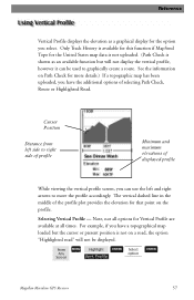
... map data is not uploaded. (Path Check is not on the profile. Selecting Vertical Profile - For example, if you have the additional options of displayed profile While viewing the vertical profile screen, you select. Only Track History is available for this function if MapSend Topo...can use the left side to move the profile accordingly. From Any Screen MENU Highlight Vert. Profile ENTER Select option ENTER Magellan Meridian GPS Receiver 57 The vertical dashed line in the middle of the profile plot provides the elevation for Vertical Profile are available at all ...
... map data is not uploaded. (Path Check is not on the profile. Selecting Vertical Profile - For example, if you have the additional options of displayed profile While viewing the vertical profile screen, you select. Only Track History is available for this function if MapSend Topo...can use the left side to move the profile accordingly. From Any Screen MENU Highlight Vert. Profile ENTER Select option ENTER Magellan Meridian GPS Receiver 57 The vertical dashed line in the middle of the profile plot provides the elevation for Vertical Profile are available at all ...
User Manual
Page 66
...track that you want to the desired location of creating a route. Highlighted Road Vertical Profile Description - (Available only with map data uploaded from Magellan MapSend Topo for the road you can view the vertical profile for the route. Route Vertical Profile Description - (Available only with the... from Magellan MapSend Topo for the path is done, press [ENTER] and the vertical profile for the United States.) If you can also save this path into a stored route by simply pressing the MENU key and selecting the Save To Route option. 58 Magellan Meridian GPS Receiver Now...
...track that you want to the desired location of creating a route. Highlighted Road Vertical Profile Description - (Available only with map data uploaded from Magellan MapSend Topo for the road you can view the vertical profile for the route. Route Vertical Profile Description - (Available only with the... from Magellan MapSend Topo for the path is done, press [ENTER] and the vertical profile for the United States.) If you can also save this path into a stored route by simply pressing the MENU key and selecting the Save To Route option. 58 Magellan Meridian GPS Receiver Now...
User Manual
Page 91
...detailed street maps as well as POI's to your PC for easy viewing in 8, 16, 32 or 64 MB configurations. MapSend® Topo for external power. Vehicle Mounting Bracket: Full swivel and tilt for data transfer and to connect your Meridian receiver....maps, topographic data as well as extensive sets of carrying the Meridian on your belt while at the same time protecting it from Magellan at (800) 669-4477 (press 3 to external power and data. External Power Cable with United States topographic information.) Secure Digital (SD) Memory Cards: Available in any vehicle. Magellan Meridian GPS...
...detailed street maps as well as POI's to your PC for easy viewing in 8, 16, 32 or 64 MB configurations. MapSend® Topo for external power. Vehicle Mounting Bracket: Full swivel and tilt for data transfer and to connect your Meridian receiver....maps, topographic data as well as extensive sets of carrying the Meridian on your belt while at the same time protecting it from Magellan at (800) 669-4477 (press 3 to external power and data. External Power Cable with United States topographic information.) Secure Digital (SD) Memory Cards: Available in any vehicle. Magellan Meridian GPS...


