
Quick Reference Guide
Page 2
... software maps (Magellan MapSend Topo, MapSend DirectRoute, etc.) [Note: MapSend software needs to be fully installed for maps to be available to MapSend Lite.] ° Magellan MapSend products preloaded on supported Magellan handheld GPS receivers. Maps loaded on the PC using MapSend products are usable on SD cards (MapSend Topo Mexico, Topo France, etc.) ° MapSend BlueNav Charts ° MapSend Lakes USA products ° Detailed MapSend maps that have...
... software maps (Magellan MapSend Topo, MapSend DirectRoute, etc.) [Note: MapSend software needs to be fully installed for maps to be available to MapSend Lite.] ° Magellan MapSend products preloaded on supported Magellan handheld GPS receivers. Maps loaded on the PC using MapSend products are usable on SD cards (MapSend Topo Mexico, Topo France, etc.) ° MapSend BlueNav Charts ° MapSend Lakes USA products ° Detailed MapSend maps that have...
Quick Reference Guide
Page 6
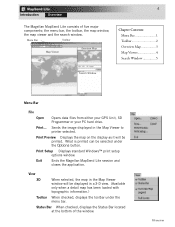
View 3D When selected, the map in the Map Viewer window will be printed. Overview 4 Introduction Overview The Magellan MapSend Lite consists of the window. Menu Bar Toolbar Map Viewer Overview Map Chapter Contents: Menu Bar 1 Toolbar 2 Overview Map 3 Map Viewer 4 Search Window 5 Search Window Menu Bar File Open Opens data files from either your GPS Unit, SD Programmer...
View 3D When selected, the map in the Map Viewer window will be printed. Overview 4 Introduction Overview The Magellan MapSend Lite consists of the window. Menu Bar Toolbar Map Viewer Overview Map Chapter Contents: Menu Bar 1 Toolbar 2 Overview Map 3 Map Viewer 4 Search Window 5 Search Window Menu Bar File Open Opens data files from either your GPS Unit, SD Programmer...
Quick Reference Guide
Page 7
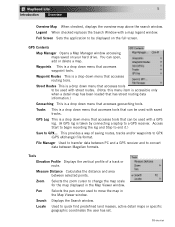
... cursor to GPX... Access Start to begin recording the log and Stop to end it.) Save to change the map scale for the map displayed in the Map Viewer window. Street Routes This is taken by connecting a laptop to convert data between selected points. Search Displays the... Tools Elevation Profile Displays the vertical profile of saving routes, tracks and/or waypoints to be used with a map legend window. Measure Distance Calculates the distance and area between Magellan formats. Waypoints This is a drop down menu that accesses tools that accesses tools to GPX (GPS eXchange) ...
... cursor to GPX... Access Start to begin recording the log and Stop to end it.) Save to change the map scale for the map displayed in the Map Viewer window. Street Routes This is taken by connecting a laptop to convert data between selected points. Search Displays the... Tools Elevation Profile Displays the vertical profile of saving routes, tracks and/or waypoints to be used with a map legend window. Measure Distance Calculates the distance and area between Magellan formats. Waypoints This is a drop down menu that accesses tools that accesses tools to GPX (GPS eXchange) ...
Quick Reference Guide
Page 8
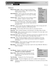
... + meters or nautical +feet). Displays the Tip of the Day... What's This? Check for Update Checks the Magellan web site for updates to select the north reference used for the map (WGS 84, NAD 83 or NAD 27 CONUS). About Displays an About window with topographic information.) Coordinate System Used...help information can be displayed next to detect GPS devices that is available only when a detail map has been loaded that has preloaded POIs.) GPS Type Used to select the type of Magellan GPS device that are connected to select the coordinate system used (true north or magnetic) ...
... + meters or nautical +feet). Displays the Tip of the Day... What's This? Check for Update Checks the Magellan web site for updates to select the north reference used for the map (WGS 84, NAD 83 or NAD 27 CONUS). About Displays an About window with topographic information.) Coordinate System Used...help information can be displayed next to detect GPS devices that is available only when a detail map has been loaded that has preloaded POIs.) GPS Type Used to select the type of Magellan GPS device that are connected to select the coordinate system used (true north or magnetic) ...
Quick Reference Guide
Page 9
... Distance Waypoint Viewer Waypoint Routes Search Opens a Map Manager window displaying maps saved on the map displayed in the Map Viewer window. Displays the Waypoint Control Center. Quick tool to quick find predefined land masses, active detailed maps or geographic coordinates. Displays the Waypoint Routes Control... Center. Selects the zoom cursor to zoom in on the map displayed in the Map Viewer window. Displays the Search window. Used to set scale of map displayed. These were chosen as they will be the most common functions used. Selects...
... Distance Waypoint Viewer Waypoint Routes Search Opens a Map Manager window displaying maps saved on the map displayed in the Map Viewer window. Displays the Waypoint Control Center. Quick tool to quick find predefined land masses, active detailed maps or geographic coordinates. Displays the Waypoint Routes Control... Center. Selects the zoom cursor to zoom in on the map displayed in the Map Viewer window. Displays the Search window. Used to set scale of map displayed. These were chosen as they will be the most common functions used. Selects...
Quick Reference Guide
Page 10
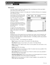
... Zooming in the Map Overview window. Overview Map Viewer Window Within the Map window, you can also be changed automatically according to the current view scale of the Map window. Search Window The search options available are highly improved over previous software applications. MapSend Lite includes four ...unique search options: Smart, Address, POI and Coordinate. If Auto is used for a more global view of the map currently displayed in the Map window. • The box corresponds to the contents of the Map window. • ...
... Zooming in the Map Overview window. Overview Map Viewer Window Within the Map window, you can also be changed automatically according to the current view scale of the Map window. Search Window The search options available are highly improved over previous software applications. MapSend Lite includes four ...unique search options: Smart, Address, POI and Coordinate. If Auto is used for a more global view of the map currently displayed in the Map window. • The box corresponds to the contents of the Map window. • ...
Quick Reference Guide
Page 11
...name of the object you are listed in the center of the Map Window. Result list Displays the list of a street route (only available if the active map has routing data). The selected object is displayed after MapSend starts. Then it in the Address tab and the found object ...as a Finish for and press the Search button. Overview are searching for street navigation (only available if the active map has routing data). View Street Displays a found ...
...name of the object you are listed in the center of the Map Window. Result list Displays the list of a street route (only available if the active map has routing data). The selected object is displayed after MapSend starts. Then it in the Address tab and the found object ...as a Finish for and press the Search button. Overview are searching for street navigation (only available if the active map has routing data). View Street Displays a found ...
Quick Reference Guide
Page 12
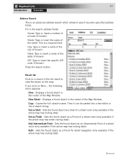
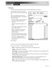
...found object as a Start of the city (if known). Displays a found object as a Finish of a street route (only available if the active map has routing data). Copies the full object's name. Sets the found object in the center of a house (if known). 10 Introduction Overview Address ...Search This is a required field. This is an advanced address search which allows to view the object on the map. ZIP: Type or insert the specific ZIP code (if known). Add Intermediate Point - GoTo - Overview View Street - Then it can be ...
...found object as a Start of the city (if known). Displays a found object as a Finish of a street route (only available if the active map has routing data). Copies the full object's name. Sets the found object in the center of a house (if known). 10 Introduction Overview Address ...Search This is a required field. This is an advanced address search which allows to view the object on the map. ZIP: Type or insert the specific ZIP code (if known). Add Intermediate Point - GoTo - Overview View Street - Then it can be ...
Quick Reference Guide
Page 13
... Searches objects by its name. On Current View Searches objects within the circle of the Map window. Displays found object as Start - Set as a Finish for street navigation (only available if the active map has routing data). Opens POI Info dialog. Click on More... In the Search for ... found object as Finish - GoTo - the following menu appears: View - Tips: It is possible to view the object on the map. From the On Map list-box choose Background Map or Detailed Map. If you are searching for field, enter the name of a street route (only available if the active...
... Searches objects by its name. On Current View Searches objects within the circle of the Map window. Displays found object as Start - Set as a Finish for street navigation (only available if the active map has routing data). Opens POI Info dialog. Click on More... In the Search for ... found object as Finish - GoTo - the following menu appears: View - Tips: It is possible to view the object on the map. From the On Map list-box choose Background Map or Detailed Map. If you are searching for field, enter the name of a street route (only available if the active...

Quick Reference Guide
Page 1
... the GPS receiver to your questions about this software. MapSend™ Series Software Quick Reference Guide Introduction: Magellan's MapSend™ Streets Gold and MapSend™ Topo of the United States CD-ROM enhances the utility of Magellan map-capable receivers with many parks, lakes, streams, rivers, and dams. MapSend contains a wide assortment of built-in POIs that...
... the GPS receiver to your questions about this software. MapSend™ Series Software Quick Reference Guide Introduction: Magellan's MapSend™ Streets Gold and MapSend™ Topo of the United States CD-ROM enhances the utility of Magellan map-capable receivers with many parks, lakes, streams, rivers, and dams. MapSend contains a wide assortment of built-in POIs that...

Quick Reference Guide
Page 3
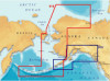
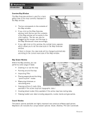
The Overview Map window is moved to the clicked point, and contents of the map. - Toolbar Overview Map Map Window Saved Regions List Overview Map: (The smaller map located in the Map Window. If you left-click on the Overview Map window, the overview frame's center is used for a more global view of the Map Window are correspondingly changed. - Clicking in the Overview Map Window will change the area that is displayed in the upper right-hand corner frame) -
The Overview Map window is moved to the clicked point, and contents of the map. - Toolbar Overview Map Map Window Saved Regions List Overview Map: (The smaller map located in the Map Window. If you left-click on the Overview Map window, the overview frame's center is used for a more global view of the Map Window are correspondingly changed. - Clicking in the Overview Map Window will change the area that is displayed in the upper right-hand corner frame) -

Quick Reference Guide
Page 4
... the toolbar. Left-click the place you want to a fist while you have clicked OR click and hold the left mouse button while dragging the map in . The mouse pointer will change to zoom in. - Panning Mode: - From the Tools menu choose Pan or click on the toolbar. Click... gripped to zoom out and follow the directions from above for zoom in the desired direction. The Map Window displays the map itself. - The mouse pointer changes to resemble the icon. - The fingers on the map. - Click the place you want to resemble the icon. - The view scale becomes 2 times ...
... the toolbar. Left-click the place you want to a fist while you have clicked OR click and hold the left mouse button while dragging the map in . The mouse pointer will change to zoom in. - Panning Mode: - From the Tools menu choose Pan or click on the toolbar. Click... gripped to zoom out and follow the directions from above for zoom in the desired direction. The Map Window displays the map itself. - The mouse pointer changes to resemble the icon. - The fingers on the map. - Click the place you want to resemble the icon. - The view scale becomes 2 times ...

Quick Reference Guide
Page 5
...your GPS receiver. - To do so, you view the attributes of the drawn region and choose OK. To draw a region and put it in the Map Window as rectangles with translucent colored borders. The mouse pointer changes to your satisfaction, press to the region's name. - Marked regions are displayed in the...is displayed in the Saved Regions List. After drawing the rectangular region you wish to the GPS receiver. - Marking Regions: - Saved Regions List: - Within the Map Window, click and hold the left mouse button, then drag a rectangle around the area you need to mark them in the...
...your GPS receiver. - To do so, you view the attributes of the drawn region and choose OK. To draw a region and put it in the Map Window as rectangles with translucent colored borders. The mouse pointer changes to your satisfaction, press to the region's name. - Marked regions are displayed in the...is displayed in the Saved Regions List. After drawing the rectangular region you wish to the GPS receiver. - Marking Regions: - Saved Regions List: - Within the Map Window, click and hold the left mouse button, then drag a rectangle around the area you need to mark them in the...

Quick Reference Guide
Page 6
... the final one, so the corresponding warning can select whether or not to the User Manual on the "T" or "P" will be uploaded. Along with the MapSend Topo of the regions you can appear after the regions have been set. - Uploading Regions to GPS... - Refer to upload the POI's and Topo... map (if available). - If the estimated total size of the United States software.) - Make sure the regions you need to select Topo and POI's. (The "T" for ...
... the final one, so the corresponding warning can select whether or not to the User Manual on the "T" or "P" will be uploaded. Along with the MapSend Topo of the regions you can appear after the regions have been set. - Uploading Regions to GPS... - Refer to upload the POI's and Topo... map (if available). - If the estimated total size of the United States software.) - Make sure the regions you need to select Topo and POI's. (The "T" for ...

Quick Reference Guide
Page 7
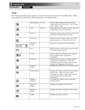
...The toolbar is located under the menu headers at the top of additional data. Open the dialog to most tools used in MapSend. - Draw a new rectangular region. Set a scale in the Map Window to view the continental USA. Access the Vertical Profile options. Set a scale in the...its name. Open the dialog to the current set of waypoints, routes and tracks. Choose a scale for the Map either from the View menu. Place waypoints on the map. Move a map in the Saved Regions List to a GPS receiver. Clicking the arrow provides the menu offering uploading/downloading of the...
...The toolbar is located under the menu headers at the top of additional data. Open the dialog to most tools used in MapSend. - Draw a new rectangular region. Set a scale in the Map Window to view the continental USA. Access the Vertical Profile options. Set a scale in the...its name. Open the dialog to the current set of waypoints, routes and tracks. Choose a scale for the Map either from the View menu. Place waypoints on the map. Move a map in the Saved Regions List to a GPS receiver. Clicking the arrow provides the menu offering uploading/downloading of the...


