
Quick Reference Guide
Page 2
... cards (MapSend Topo Mexico, Topo France, etc.) ° MapSend BlueNav Charts ° MapSend Lakes USA products ° Detailed MapSend maps that have been loaded in the Magellan eXplorist. ° Background maps preloaded in a Magellan eXplorist ° "Magellan Certified" products created and distributed by third-parties. • Create, edit and visualize user data, such as waypoints, tracks, routes and geocaches. • Give access to utilities to convert user data between popular Magellan...
... cards (MapSend Topo Mexico, Topo France, etc.) ° MapSend BlueNav Charts ° MapSend Lakes USA products ° Detailed MapSend maps that have been loaded in the Magellan eXplorist. ° Background maps preloaded in a Magellan eXplorist ° "Magellan Certified" products created and distributed by third-parties. • Create, edit and visualize user data, such as waypoints, tracks, routes and geocaches. • Give access to utilities to convert user data between popular Magellan...
Quick Reference Guide
Page 3
... • Minimum of 20 MB hard disk space • DirectX 8.0 compatible video card Installation Magellan MapSend Lite is satisfactory.) The Magellan MapSend Lite will begin the installation. Follow the onscreen instructions to : http://www.magellangps.com/support/mapsendlite/ 1. Locate the link to download the application and follow the instructions provided to download the installer to your browser to Choose Destination Location and Select Program...
... • Minimum of 20 MB hard disk space • DirectX 8.0 compatible video card Installation Magellan MapSend Lite is satisfactory.) The Magellan MapSend Lite will begin the installation. Follow the onscreen instructions to : http://www.magellangps.com/support/mapsendlite/ 1. Locate the link to download the application and follow the instructions provided to download the installer to your browser to Choose Destination Location and Select Program...
Quick Reference Guide
Page 4
... a text readme file that contains legal information on the MapSend-Warning window. (Note: If you have a Magellan GPS Firmware Update CD-ROM, check the support secton of www.magellanGPS.com for each model of the MapSend Lite application. If you need to install new software follow the instructions provided on copyrights and trademarks used. • MapSend Lite Help opens up a help file that can...
... a text readme file that contains legal information on the MapSend-Warning window. (Note: If you have a Magellan GPS Firmware Update CD-ROM, check the support secton of www.magellanGPS.com for each model of the MapSend Lite application. If you need to install new software follow the instructions provided on copyrights and trademarks used. • MapSend Lite Help opens up a help file that can...
Quick Reference Guide
Page 5
You can update now or close the window and update later. The application opens and is displayed. The next chapter descibes the major components of new updates is performed. If there is an update to the application, an auto update window is ready for use. Introduction 4 Introduction Overview 3 Every time you launch the Magellan MapSend Lite application, a check of the Magellan MapSend Lite application.
You can update now or close the window and update later. The application opens and is displayed. The next chapter descibes the major components of new updates is performed. If there is an update to the application, an auto update window is ready for use. Introduction 4 Introduction Overview 3 Every time you launch the Magellan MapSend Lite application, a check of the Magellan MapSend Lite application.
Quick Reference Guide
Page 6
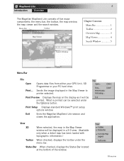
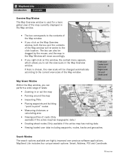
... selected under the menu bar. Menu Bar Toolbar Map Viewer Overview Map Chapter Contents: Menu Bar 1 Toolbar 2 Overview Map 3 Map Viewer 4 Search Window 5 Search Window Menu Bar File Open Opens data files from either your GPS Unit, SD Programmer or your PC hard drive. 4 Introduction Overview The Magellan MapSend Lite consists of the window. Status Bar When checked, displays the Status Bar...
... selected under the menu bar. Menu Bar Toolbar Map Viewer Overview Map Chapter Contents: Menu Bar 1 Toolbar 2 Overview Map 3 Map Viewer 4 Search Window 5 Search Window Menu Bar File Open Opens data files from either your GPS Unit, SD Programmer or your PC hard drive. 4 Introduction Overview The Magellan MapSend Lite consists of the window. Status Bar When checked, displays the Status Bar...
Quick Reference Guide
Page 7
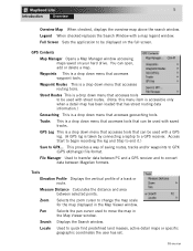
...Magellan formats. Zoom Selects the zoom cursor to move the map in the Map Viewer window. Overview This provides a way of a track or route. Full Screen Sets the application to convert data between selected points. File Manager Used to transfer data between PC and a GPS receiver and to be used to change the map scale for the map displayed in the Map Viewer window... Search window. Access Start to begin recording the log and Stop to end it.) Save to quick find predefined land masses, active detail maps or specific geographic coordinates the user has set. Locate Used to...
...Magellan formats. Zoom Selects the zoom cursor to move the map in the Map Viewer window. Overview This provides a way of a track or route. Full Screen Sets the application to convert data between selected points. File Manager Used to transfer data between PC and a GPS receiver and to be used to change the map scale for the map displayed in the Map Viewer window... Search window. Access Start to begin recording the log and Stop to end it.) Save to quick find predefined land masses, active detail maps or specific geographic coordinates the user has set. Locate Used to...
Quick Reference Guide
Page 8
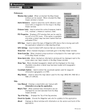
.... GPS Settings Used to detect GPS devices that are connected to the cursor when over major objects in the Map Viewer window. Show Grid When checked displays a coordinate grid in the Map Viewer window. Check for Update Checks the Magellan web site for the map (WGS 84, NAD 83 or NAD 27 CONUS). North Reference Used to this application. Map Datum Used to select the map...
.... GPS Settings Used to detect GPS devices that are connected to the cursor when over major objects in the Map Viewer window. Show Grid When checked displays a coordinate grid in the Map Viewer window. Check for Update Checks the Magellan web site for the map (WGS 84, NAD 83 or NAD 27 CONUS). North Reference Used to this application. Map Datum Used to select the map...
Quick Reference Guide
Page 9
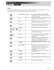
...: this menu item is accessible only when a detail map has been loaded that has street routing data information.) Calculates the distance and area between selected points. Opens data files from either your GPS Unit, SD Programmer or your hard drive. Displays the Search window. Overview Used to set scale of map displayed. 7 Introduction Overview Toolbar The Toolbar provides quick...
...: this menu item is accessible only when a detail map has been loaded that has street routing data information.) Calculates the distance and area between selected points. Opens data files from either your GPS Unit, SD Programmer or your hard drive. Displays the Search window. Overview Used to set scale of map displayed. 7 Introduction Overview Toolbar The Toolbar provides quick...
Quick Reference Guide
Page 10
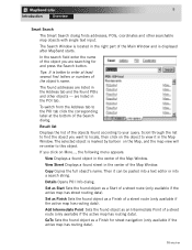
... by the mouse, and the map in the Map Window will re-center to the click location. Search Window The search options available are highly improved over previous software applications. Map Viewer Window Within the Map window, you can also be changed ...user data including waypoints, routes, tracks and geocaches. Overview The box can perform a wide range of tasks: • Zooming in the Map Overview window. If Auto is used for a more global view of the map currently displayed in the Map window. • The box corresponds to the contents of the Map window. • If you to set...
... by the mouse, and the map in the Map Window will re-center to the click location. Search Window The search options available are highly improved over previous software applications. Map Viewer Window Within the Map window, you can also be changed ...user data including waypoints, routes, tracks and geocaches. Overview The box can perform a wide range of tasks: • Zooming in the Map Overview window. If Auto is used for a more global view of the map currently displayed in the Map window. • The box corresponds to the contents of the Map window. • If you to set...
Quick Reference Guide
Page 11
...navigation (only available if the active map has routing data). Set as Finish Sets the found POIs and other searchable map objects with single text input. Scroll through the list to find the object you want to the POI tab click the corresponding label at least several first letters or numbers of the Main Window... found object as a Start of a street route (only available if the active map has routing data). Set as Start Sets the found addresses are listed in the right part of the object's name. The Search Window is located in the POI tab. Tips: It is better to enter at the...
...navigation (only available if the active map has routing data). Set as Finish Sets the found POIs and other searchable map objects with single text input. Scroll through the list to find the object you want to the POI tab click the corresponding label at least several first letters or numbers of the Main Window... found object as a Start of a street route (only available if the active map has routing data). Set as Start Sets the found addresses are listed in the right part of the object's name. The Search Window is located in the POI tab. Tips: It is better to enter at the...
Quick Reference Guide
Page 12
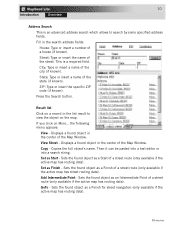
...: Type or insert the specific ZIP code (if known). Set as Finish - Sets the found object as a Start of a street route (only available if the active map has street routing data). GoTo - Result list Click on More... Copy - Sets the found object as a Finish for street navigation (only available if the active map has routing data). Street: Type or insert...
...: Type or insert the specific ZIP code (if known). Set as Finish - Sets the found object as a Start of a street route (only available if the active map has street routing data). GoTo - Result list Click on More... Copy - Sets the found object as a Finish for street navigation (only available if the active map has routing data). Street: Type or insert...
Quick Reference Guide
Page 13
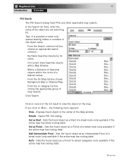
... search criterion: By Name Searches objects by its name. From the In category list-box choose the appropriate group of the Map window. Set as Finish - Sets the found object as a Finish of the object you click on record in the object name. Add Intermediate Point - Tips...is possible to enter only several starting letters or numbers in the list result to view the object on the map. Click on More... If you are searching for street navigation (only available if the active map has routing data). Set as Start - GoTo - Sets the found object as a Finish for . In...
... search criterion: By Name Searches objects by its name. From the In category list-box choose the appropriate group of the Map window. Set as Finish - Sets the found object as a Finish of the object you click on record in the object name. Add Intermediate Point - Tips...is possible to enter only several starting letters or numbers in the list result to view the object on the map. Click on More... If you are searching for street navigation (only available if the active map has routing data). Set as Start - GoTo - Sets the found object as a Finish for . In...
Quick Reference Guide
Page 14
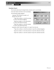
... W (west) or E (east) from the list. º Type the number or click the arrows to input the latitude degrees. ' Type the number or click the arrows to input the latitude minutes. The following dialog appears: Latitude: N/S Choose N (north) or S (south) from the list. º Type the number or click...latitude degrees. ' Type the number or click the arrows to input the latitude minutes. " Type the number or click the arrows to input the latitude seconds. " Type the number or click the arrows to input the latitude seconds. From the Search window click Coordinates. 12 Introduction ...
... W (west) or E (east) from the list. º Type the number or click the arrows to input the latitude degrees. ' Type the number or click the arrows to input the latitude minutes. The following dialog appears: Latitude: N/S Choose N (north) or S (south) from the list. º Type the number or click...latitude degrees. ' Type the number or click the arrows to input the latitude minutes. " Type the number or click the arrows to input the latitude seconds. " Type the number or click the arrows to input the latitude seconds. From the Search window click Coordinates. 12 Introduction ...

Quick Reference Guide
Page 1
... refer to the User Manual and get detailed answers to upload, download and customize data for any waypoint you can upload any USA city and airport, along with Windows 95, 98 or NT. The software's waypoint and route management features allow users to your receiver. While using MapSend, you have in the United States. MapSend Topo of POIs to your GPS receiver to be...
... refer to the User Manual and get detailed answers to upload, download and customize data for any waypoint you can upload any USA city and airport, along with Windows 95, 98 or NT. The software's waypoint and route management features allow users to your receiver. While using MapSend, you have in the United States. MapSend Topo of POIs to your GPS receiver to be...
Quick Reference Guide
Page 2
...using as you have correctly installed the MapSend software. (Please refer to the back of the PC cable with the OK button. Start the MapSend program from the Windows start menu or simply insert the MapSend CD-ROM and click on your personal computer and connect the other end of the GPS receiver. Turn on slower computers for installation instructions... to the GPS receiver). Remember which your PC is replaced with the DIN-9 connector to the GPS receiver. 3. Disconnect power from the disk into the back of data to an available COM port. Connecting the GPS Receiver to ...
...using as you have correctly installed the MapSend software. (Please refer to the back of the PC cable with the OK button. Start the MapSend program from the Windows start menu or simply insert the MapSend CD-ROM and click on your personal computer and connect the other end of the GPS receiver. Turn on slower computers for installation instructions... to the GPS receiver). Remember which your PC is replaced with the DIN-9 connector to the GPS receiver. 3. Disconnect power from the disk into the back of data to an available COM port. Connecting the GPS Receiver to ...

Quick Reference Guide
Page 3
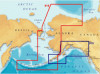
If you left-click on the Overview Map window, the overview frame's center is moved to the clicked point, and contents of the map. - The Overview Map window is displayed in the upper right-hand corner frame) - Clicking in the Overview Map Window will change the area that is used for a more global view of the Map Window are correspondingly changed. - Toolbar Overview Map Map Window Saved Regions List Overview Map: (The smaller map located in the Map Window.
If you left-click on the Overview Map window, the overview frame's center is moved to the clicked point, and contents of the map. - The Overview Map window is displayed in the upper right-hand corner frame) - Clicking in the Overview Map Window will change the area that is used for a more global view of the Map Window are correspondingly changed. - Toolbar Overview Map Map Window Saved Regions List Overview Map: (The smaller map located in the Map Window.

Quick Reference Guide
Page 4
From the Tools menu choose Pan or click on the Map Window by clicking the left mouse button within the Map Window. The map will be automatically updated as large and the map is on the toolbar. - Zooming Mode: - Left-click the place you want to zoom in . Panning Mode: - Having released the mouse button... to zoom out and follow the directions from above for zoom in . - Click the place you want to resemble the icon. - When navigating the map, make sure the focus is centered to a fist while you have clicked OR click and hold the left mouse button down and drag a ...
From the Tools menu choose Pan or click on the Map Window by clicking the left mouse button within the Map Window. The map will be automatically updated as large and the map is on the toolbar. - Zooming Mode: - Left-click the place you want to zoom in . Panning Mode: - Having released the mouse button... to zoom out and follow the directions from above for zoom in . - Click the place you want to resemble the icon. - When navigating the map, make sure the focus is centered to a fist while you have clicked OR click and hold the left mouse button down and drag a ...

Quick Reference Guide
Page 5
...with translucent colored borders. After drawing the rectangular region you need to define as translucently colored filled rectangles. Saved Regions List: - Within the Map Window, click and hold the left mouse button, then drag a rectangle around the area you have to undo. - In the Naming dialog ...To mark a region, click the corresponding check-box next to - The Saved Regions List is displayed in the Map Window as a region. - If the region is not to the GPS receiver. - To do so, you view the attributes of regions to be critical when uploading regions to your satisfaction...
...with translucent colored borders. After drawing the rectangular region you need to define as translucently colored filled rectangles. Saved Regions List: - Within the Map Window, click and hold the left mouse button, then drag a rectangle around the area you have to undo. - In the Naming dialog ...To mark a region, click the corresponding check-box next to - The Saved Regions List is displayed in the Map Window as a region. - If the region is not to the GPS receiver. - To do so, you view the attributes of regions to be critical when uploading regions to your satisfaction...

Quick Reference Guide
Page 6
...and that the upload or download process may take a certain amount of regions may differ from the Saved Regions List to your GPS receiver, you want to be uploaded have been set. - Be sure to note that the total amount of memory used to select Topo and POI's. (The ...lessen the size of the United States software.) - Estimated size of time in the dialog information box. - Refer to the User Manual on the receiver, a corresponding warning appears. After selecting (marking) a region, you have been converted. Selecting Topo and/or POIs from the GPS receiver to your PC. - Along...
...and that the upload or download process may take a certain amount of regions may differ from the Saved Regions List to your GPS receiver, you want to be uploaded have been set. - Be sure to note that the total amount of memory used to select Topo and POI's. (The ...lessen the size of the United States software.) - Estimated size of time in the dialog information box. - Refer to the User Manual on the receiver, a corresponding warning appears. After selecting (marking) a region, you have been converted. Selecting Topo and/or POIs from the GPS receiver to your PC. - Along...

Quick Reference Guide
Page 7
... the current set of additional data. Open the dialog to find a location by its address. Zoom out the Map Window. Get help on the Saved Regions List. To hide or display the Toolbar, choose Toolbar from the list or user defined. Zoom in the Map Window. Set a scale in the Map Window to most tools used in the Map Window to a GPS receiver. Place...
... the current set of additional data. Open the dialog to find a location by its address. Zoom out the Map Window. Get help on the Saved Regions List. To hide or display the Toolbar, choose Toolbar from the list or user defined. Zoom in the Map Window. Set a scale in the Map Window to most tools used in the Map Window to a GPS receiver. Place...


