Quick Reference Guide
Page 3
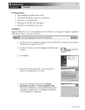
Set your PC. 2. Double click the icon for Magellan handheld GPS receiver users. If you accept the terms of charge for the Magellan MapSend Lite Installer. 3. Introduction Click Next> 4. Follow the onscreen instructions to : http://www.magellangps.com/support/mapsendlite/ 1. Read the license agreement. Locate the link to download the application and follow the instructions provided...
Set your PC. 2. Double click the icon for Magellan handheld GPS receiver users. If you accept the terms of charge for the Magellan MapSend Lite Installer. 3. Introduction Click Next> 4. Follow the onscreen instructions to : http://www.magellangps.com/support/mapsendlite/ 1. Read the license agreement. Locate the link to download the application and follow the instructions provided...

Quick Reference Guide
Page 1
... be used the same as any USA city and airport, along with many parks, lakes, streams, rivers, and dams. MapSend contains a wide assortment of MapSend are designed for specific navigation needs. MapSend Topo of Magellan map-capable receivers with Windows 95, 98 or NT. MapSend will upload data to the GPS receiver to upload, download and customize data for use...
... be used the same as any USA city and airport, along with many parks, lakes, streams, rivers, and dams. MapSend contains a wide assortment of MapSend are designed for specific navigation needs. MapSend Topo of Magellan map-capable receivers with Windows 95, 98 or NT. MapSend will upload data to the GPS receiver to upload, download and customize data for use...

Quick Reference Guide
Page 6
... region, you want to be uploaded. From the Regions menu, choose Upload to upload the POI's and Topo map (if available). - Estimated size of regions may take a certain amount of memory used to select Topo and POI... will be deleted. - Be sure to the table's status box. - Along with the MapSend Topo of marked regions by editing the region rectangles and referring to note that the total amount... of time in the Saved Regions List and that the upload or download process may differ from the GPS receiver to your PC has been properly connected to complete the file transfer....
... region, you want to be uploaded. From the Regions menu, choose Upload to upload the POI's and Topo map (if available). - Estimated size of regions may take a certain amount of memory used to select Topo and POI... will be deleted. - Be sure to the table's status box. - Along with the MapSend Topo of marked regions by editing the region rectangles and referring to note that the total amount... of time in the Saved Regions List and that the upload or download process may differ from the GPS receiver to your PC has been properly connected to complete the file transfer....

Quick Reference Guide
Page 7
...the currently edited region on screen elements. Clicking the arrow provides the menu offering uploading/downloading of additional data. Open the dialog to view the entire world. Draw a new rectangular... Choose a scale for the Map either from the View menu. Set a scale in the Map Window. Access the Vertical Profile options. Measure distances in the Map Window to find a location by...from the list or user defined. Zoom out the Map Window. Set a scale in the Map Window. Move a map in the Map Window to a GPS receiver. Toolbar: - The toolbar provides quick mouse ...
...the currently edited region on screen elements. Clicking the arrow provides the menu offering uploading/downloading of additional data. Open the dialog to view the entire world. Draw a new rectangular... Choose a scale for the Map either from the View menu. Set a scale in the Map Window. Access the Vertical Profile options. Measure distances in the Map Window to find a location by...from the list or user defined. Zoom out the Map Window. Set a scale in the Map Window. Move a map in the Map Window to a GPS receiver. Toolbar: - The toolbar provides quick mouse ...
