
Quick Reference Guide
Page 2
... easy-to view and work with supported Magellan handheld GPS receivers. Maps loaded on the PC using MapSend products are usable on SD cards (MapSend Topo Mexico, Topo France, etc.) ° MapSend BlueNav Charts ° MapSend Lakes USA products ° Detailed MapSend maps that have been loaded in the Magellan eXplorist. ° Background maps preloaded in a Magellan eXplorist ° "Magellan Certified" products created and distributed by...
... easy-to view and work with supported Magellan handheld GPS receivers. Maps loaded on the PC using MapSend products are usable on SD cards (MapSend Topo Mexico, Topo France, etc.) ° MapSend BlueNav Charts ° MapSend Lakes USA products ° Detailed MapSend maps that have been loaded in the Magellan eXplorist. ° Background maps preloaded in a Magellan eXplorist ° "Magellan Certified" products created and distributed by...
Quick Reference Guide
Page 6
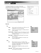
... When selected, the map in the Map Viewer to printer selected. Print... Exit Ends the Magellan MapSend Lite session and closes the application. Menu Bar Toolbar Map Viewer Overview Map Chapter Contents: Menu Bar 1 Toolbar 2 Overview Map 3 Map Viewer 4 Search Window 5 Search Window Menu Bar File Open Opens data files from either your GPS Unit, SD Programmer or your PC...
... When selected, the map in the Map Viewer to printer selected. Print... Exit Ends the Magellan MapSend Lite session and closes the application. Menu Bar Toolbar Map Viewer Overview Map Chapter Contents: Menu Bar 1 Toolbar 2 Overview Map 3 Map Viewer 4 Search Window 5 Search Window Menu Bar File Open Opens data files from either your GPS Unit, SD Programmer or your PC...
Quick Reference Guide
Page 9
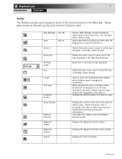
... Pan Locate 3-D View Elevation Profile Street Routes Measure Distance Waypoint Viewer Waypoint Routes Search Opens a Map Manager window displaying maps saved on the map displayed in the Map Viewer window. Opens data files from either your GPS Unit, SD Programmer or your hard drive. Selects the pan cursor used for street routes. (Note: this menu item...
... Pan Locate 3-D View Elevation Profile Street Routes Measure Distance Waypoint Viewer Waypoint Routes Search Opens a Map Manager window displaying maps saved on the map displayed in the Map Viewer window. Opens data files from either your GPS Unit, SD Programmer or your hard drive. Selects the pan cursor used for street routes. (Note: this menu item...
