Installation Manual
Page 6
...Genesis) • StructureMap™ (StructureMap) • StructureScan® (StructureScan) • StructureScan® HD (StructureScan HD) 6 Preface | ELITE Ti Installation Manual SI - Sweden CH - Simrad® is a registered trademark of Jeppesen. SD™ and microSD™ are registered trademarks of ... Marine Electronics Association. Turkey UK - United Kingdom Trademarks Lowrance® and Navico® are registered trademarks of JL Marine Systems, Inc. Navionics® is a registered trademark of Navionics, Inc. Copyright© 2012 Fishing Hot Spots. Wi...
...Genesis) • StructureMap™ (StructureMap) • StructureScan® (StructureScan) • StructureScan® HD (StructureScan HD) 6 Preface | ELITE Ti Installation Manual SI - Sweden CH - Simrad® is a registered trademark of Jeppesen. SD™ and microSD™ are registered trademarks of ... Marine Electronics Association. Turkey UK - United Kingdom Trademarks Lowrance® and Navico® are registered trademarks of JL Marine Systems, Inc. Navionics® is a registered trademark of Navionics, Inc. Copyright© 2012 Fishing Hot Spots. Wi...

Installation Manual
Page 12
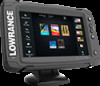
...DC systems. Front controls 1 2 3 4 5 6 1 Touch screen 2 Pages 3 Zoom out / Zoom in CHIRP/Broadband and StructureScan sonar. The ELITE-7Ti can send and receive data via NMEA 0183. For a full selection of third party mapping providers in high speed GPS receiver (10Hz) and supports... Insight charts from Navionics and Jeppesen as well as content created by a variety of available charts, visit gofreeshop.com, c-map.jeppesen.com, or navionics.com. 2 12 Overview The unit has a built-in (combined press = MOB) Overview | ELITE Ti Installation Manual The unit may be...
...DC systems. Front controls 1 2 3 4 5 6 1 Touch screen 2 Pages 3 Zoom out / Zoom in CHIRP/Broadband and StructureScan sonar. The ELITE-7Ti can send and receive data via NMEA 0183. For a full selection of third party mapping providers in high speed GPS receiver (10Hz) and supports... Insight charts from Navionics and Jeppesen as well as content created by a variety of available charts, visit gofreeshop.com, c-map.jeppesen.com, or navionics.com. 2 12 Overview The unit has a built-in (combined press = MOB) Overview | ELITE Ti Installation Manual The unit may be...
Getting Started EN
Page 16
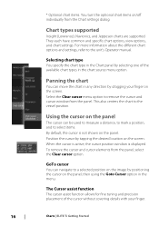
... the chart You can be used to measure a distance, to mark a position, and to a selected position on the image by dragging your finger. 16 Charts | ELITE Ti Getting Started Using the cursor on the panel The cursor can move the chart in any direction by positioning the cursor on /off individually from.... * Optional chart items. You turn the optional chart items on the panel, then using the Goto Cursor option in the menu. Chart types supported Insight (Lowrance), Navionics, and Jeppesen charts are supported.
... the chart You can be used to measure a distance, to mark a position, and to a selected position on the image by dragging your finger. 16 Charts | ELITE Ti Getting Started Using the cursor on the panel The cursor can move the chart in any direction by positioning the cursor on /off individually from.... * Optional chart items. You turn the optional chart items on the panel, then using the Goto Cursor option in the menu. Chart types supported Insight (Lowrance), Navionics, and Jeppesen charts are supported.
Operators Manual EN
Page 3
...represents the product as at any Translation of the Documentation, the English language version of Fishing Hot Spots Inc. Navionics® is a registered trademark of the Documentation will not cause accidents, personal injury or property damage. Fishing ...Navionics, Inc. Navico Holding AS and its subsidiaries, branches and affiliates reserve the right to make changes to , or has been translated from Kongsberg. Trademarks Lowrance® and Navico® are registered trademarks of the National Marine Electronics Association. Copyright© 2012 Fishing Hot Spots. Preface | ELITE Ti...
...represents the product as at any Translation of the Documentation, the English language version of Fishing Hot Spots Inc. Navionics® is a registered trademark of the Documentation will not cause accidents, personal injury or property damage. Fishing ...Navionics, Inc. Navico Holding AS and its subsidiaries, branches and affiliates reserve the right to make changes to , or has been translated from Kongsberg. Trademarks Lowrance® and Navico® are registered trademarks of the National Marine Electronics Association. Copyright© 2012 Fishing Hot Spots. Preface | ELITE Ti...
Operators Manual EN
Page 10
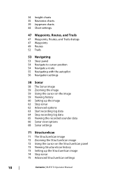
34 Insight charts 35 Navionics charts 39 Jeppesen charts 44 Chart settings 47 Waypoints, Routes, and Trails 47 Waypoints, Routes, and Trails dialogs 47 Waypoints 49 Routes 52 Trails 53 ... the cursor on the StructureScan panel 73 Viewing StructureScan history 73 Setting up the StructureScan image 74 Stop sonar 75 Advanced StructureScan settings 10 Contents | ELITE Ti Operator Manual
34 Insight charts 35 Navionics charts 39 Jeppesen charts 44 Chart settings 47 Waypoints, Routes, and Trails 47 Waypoints, Routes, and Trails dialogs 47 Waypoints 49 Routes 52 Trails 53 ... the cursor on the StructureScan panel 73 Viewing StructureScan history 73 Setting up the StructureScan image 74 Stop sonar 75 Advanced StructureScan settings 10 Contents | ELITE Ti Operator Manual
Operators Manual EN
Page 29
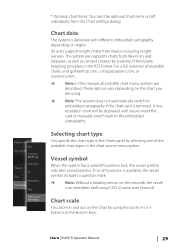
... selecting one of the available chart types in the Chart panel by a variety of available charts, visit gofreeshop.com, c-map.jeppesen.com, or navionics.com. Ú Note: In this manual, all possible chart menu options are using. Ú Note: The system does not automatically switch to...is removed. For a full selection of third party mapping providers in and out on the chart by using COG (Course over Ground). Charts | ELITE Ti Operator Manual 29 A lowresolution chart will be displayed until you are described. If no GPS position is available, the vessel symbol includes a question ...
... selecting one of the available chart types in the Chart panel by a variety of available charts, visit gofreeshop.com, c-map.jeppesen.com, or navionics.com. Ú Note: In this manual, all possible chart menu options are using. Ú Note: The system does not automatically switch to...is removed. For a full selection of third party mapping providers in and out on the chart by using COG (Course over Ground). Charts | ELITE Ti Operator Manual 29 A lowresolution chart will be displayed until you are described. If no GPS position is available, the vessel symbol includes a question ...
Operators Manual EN
Page 35
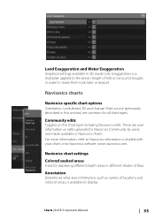
... Chart source (previously described in different shades of hills on the chart layer including Navionics edits. These are common for all chart types. Charts | ELITE Ti Operator Manual 35 Community edits Toggles on land, and troughs in water to Navionics Community by users, and made available in 3D mode only. Land Exaggeration and Water...
... Chart source (previously described in different shades of hills on the chart layer including Navionics edits. These are common for all chart types. Charts | ELITE Ti Operator Manual 35 Community edits Toggles on land, and troughs in water to Navionics Community by users, and made available in 3D mode only. Land Exaggeration and Water...
Operators Manual EN
Page 36
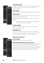
.... Chart details Provides you to declutter charts in Navionics database features data down to 20 m, after which it is drawn without blue shading. Ú Note: The built in areas where there are related to show the tides and currents evolution over time. 36 Charts | ELITE Ti Operator Manual Safety depth, based on a selected...
.... Chart details Provides you to declutter charts in Navionics database features data down to 20 m, after which it is drawn without blue shading. Ú Note: The built in areas where there are related to show the tides and currents evolution over time. 36 Charts | ELITE Ti Operator Manual Safety depth, based on a selected...
Operators Manual EN
Page 38
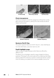
This allows you to the nearest available contour line. 38 Charts | ELITE Ti Operator Manual Minimum transparency Maximum transparency Navionics Fish N' Chip The system supports Navionics Fish N' Chip (U.S. The range is only as accurate as the underlying chart data, meaning that if the chart only contains... Select a range of depths for contour lines, the shading is rounded to highlight a specific range of depths between which Navionics fills with a different color. With minimum transparency settings the chart details are almost hidden by the photo. For more information, see www...
This allows you to the nearest available contour line. 38 Charts | ELITE Ti Operator Manual Minimum transparency Maximum transparency Navionics Fish N' Chip The system supports Navionics Fish N' Chip (U.S. The range is only as accurate as the underlying chart data, meaning that if the chart only contains... Select a range of depths for contour lines, the shading is rounded to highlight a specific range of depths between which Navionics fills with a different color. With minimum transparency settings the chart details are almost hidden by the photo. For more information, see www...
Operators Manual EN
Page 79
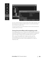
...resolution files. High resolution .smf files capture more detail, but take longer to remove the StructureScan (.sl2) files after conversion. StructureMap | ELITE Ti Operator Manual 79 To save disc space it is recommended to convert and are larger than standard resolution files. We recommend keeping copies of ...StructureMap files on external mapping cards. You can be used with embedded cartography as well as Navionics, Insight and other third-party charting cards compatible with mapping cards StructureMap allows you to the unit's internal memory.
...resolution files. High resolution .smf files capture more detail, but take longer to remove the StructureScan (.sl2) files after conversion. StructureMap | ELITE Ti Operator Manual 79 To save disc space it is recommended to convert and are larger than standard resolution files. We recommend keeping copies of ...StructureMap files on external mapping cards. You can be used with embedded cartography as well as Navionics, Insight and other third-party charting cards compatible with mapping cards StructureMap allows you to the unit's internal memory.
Operators Manual EN
Page 124
... objects 32 Insight 34 Chart categories 34 Exaggeration 35 Imagery style 34 Jeppesen Tides and currents 39 Look ahead 31 Measuring distance 22 Navionics 35, 36 Annotation 35 Chart details 36 Chart shading 36 Colored seabed areas 35 Community edits 35 Contours depth 36 Depth highlight range... Safety depth 36 Shallow water highlight 39 Orientation 30 Overlay 33 Panning 30 Photo overlay, Jeppesen 42 Photo overlay, Navionics 37 Photo transparency, Jeppesen 42 Photo transparency, Navionics 38 Positioning the vessel on the chart panel 30 Selecting chart type 29 Settings 44 Symbol 30 Using the cursor...
... objects 32 Insight 34 Chart categories 34 Exaggeration 35 Imagery style 34 Jeppesen Tides and currents 39 Look ahead 31 Measuring distance 22 Navionics 35, 36 Annotation 35 Chart details 36 Chart shading 36 Colored seabed areas 35 Community edits 35 Contours depth 36 Depth highlight range... Safety depth 36 Shallow water highlight 39 Orientation 30 Overlay 33 Panning 30 Photo overlay, Jeppesen 42 Photo overlay, Navionics 37 Photo transparency, Jeppesen 42 Photo transparency, Navionics 38 Positioning the vessel on the chart panel 30 Selecting chart type 29 Settings 44 Symbol 30 Using the cursor...