Brochure
Page 1
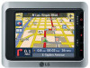
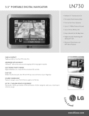
... puts clear 2D and 3D map views and menus at less than 0.8 inches thin. advanced gps accuracy SiRFstarIII™ delivers fast and accurate mapping with SiRFstarIII™ GPS • Electronic Photo Viewer and MP3 Music Playback SLIM & Compact Highly portable at your fingertips.... up to navigate across North America right out of the box. www.LGusa.com 3.5" Portable digital navigator LN730 • Brilliant 3.5" Touchscreen LCD...
... puts clear 2D and 3D map views and menus at less than 0.8 inches thin. advanced gps accuracy SiRFstarIII™ delivers fast and accurate mapping with SiRFstarIII™ GPS • Electronic Photo Viewer and MP3 Music Playback SLIM & Compact Highly portable at your fingertips.... up to navigate across North America right out of the box. www.LGusa.com 3.5" Portable digital navigator LN730 • Brilliant 3.5" Touchscreen LCD...

Brochure
Page 2
...Warranty 1 Year Parts/90 Days Labor MAPS AND MENUS LG Electronics U.S.A., Inc. 1000 Sylvan Avenue, Englewood Cliffs, NJ 07632 (800)243-0000 © 2007 LG Electronics U.S.A., Inc., Englewood Cliffs, NJ. 3.5" Portable digital navigator LN730 display AND audio performance Screen Size and Type 3.5" Touchscreen.../Pedestrian Convenience On-Screen Help • General performance and memory Battery Life Battery Type GPS Positioning Memory Capacity Memory Type media viewer Photo Viewer Music Playback connectivity SD Card Slot...
...Warranty 1 Year Parts/90 Days Labor MAPS AND MENUS LG Electronics U.S.A., Inc. 1000 Sylvan Avenue, Englewood Cliffs, NJ 07632 (800)243-0000 © 2007 LG Electronics U.S.A., Inc., Englewood Cliffs, NJ. 3.5" Portable digital navigator LN730 display AND audio performance Screen Size and Type 3.5" Touchscreen.../Pedestrian Convenience On-Screen Help • General performance and memory Battery Life Battery Type GPS Positioning Memory Capacity Memory Type media viewer Photo Viewer Music Playback connectivity SD Card Slot...

User Manual
Page 2
... / Side panel 17 Connecting devices 18-25 Installation sequence for the suction-cup mount . . . . .18-19 Detaching the suction-cup mount 20 Installing the external GPS antenna (Optional 20-21 Installing Microsoft ActiveSync 22 Connecting the USB cable 22-23 Downloading files: ActiveSync 23 Data exchange via card reader 24 Downloading...
... / Side panel 17 Connecting devices 18-25 Installation sequence for the suction-cup mount . . . . .18-19 Detaching the suction-cup mount 20 Installing the external GPS antenna (Optional 20-21 Installing Microsoft ActiveSync 22 Connecting the USB cable 22-23 Downloading files: ActiveSync 23 Data exchange via card reader 24 Downloading...
User Manual
Page 3
... Setting Stops Along the Route 48 Route Options 49 Setup 50-56 Display 50 Map Views 51 Units & Time 52 Language 52 Guidance 52-23 GPS Status 53 GPS Not Found 54 Map Setup 54-55 Tutorial 55 Help 55 Start Demo 55 Select Map 56 Initialize 56 3
... Setting Stops Along the Route 48 Route Options 49 Setup 50-56 Display 50 Map Views 51 Units & Time 52 Language 52 Guidance 52-23 GPS Status 53 GPS Not Found 54 Map Setup 54-55 Tutorial 55 Help 55 Start Demo 55 Select Map 56 Initialize 56 3

User Manual
Page 5
... SPLIT COVER(OR BACK) NO USER SERVICEABLE PARTS INSIDE. Batteryshall not be of sufficient magnitude to constitute a risk of the GPS hardware and GPS operating software. To disconnect power from the mains, pull out the mains cord plug. UL has only tested for fire, ...outlined in the literature accompanying the appliance. UL MAKES NO REPRESENTATIONS, WARRANTIES OR CERTIFICATIONS WHATSOEVER REGARDING THE PERFORMANCE OR RELIABILITY OF ANY GPS RELATED FUNCTIONS OF THIS PRODUCT. 5 The lightning flash with arrowhead symbol, within an equilateral triangle is intended to alert the user...
... SPLIT COVER(OR BACK) NO USER SERVICEABLE PARTS INSIDE. Batteryshall not be of sufficient magnitude to constitute a risk of the GPS hardware and GPS operating software. To disconnect power from the mains, pull out the mains cord plug. UL has only tested for fire, ...outlined in the literature accompanying the appliance. UL MAKES NO REPRESENTATIONS, WARRANTIES OR CERTIFICATIONS WHATSOEVER REGARDING THE PERFORMANCE OR RELIABILITY OF ANY GPS RELATED FUNCTIONS OF THIS PRODUCT. 5 The lightning flash with arrowhead symbol, within an equilateral triangle is intended to alert the user...

User Manual
Page 15
Supplied parts Main Body GPS Antenna (Optional) Suction-Cup Mount USB Cable Cigarette Lighter Carrying Case Adapter (Optional) Installation CD Quick Reference Guide AC Adapter (Optional) Contents may be changed without notice. Supporter of Cradle 15
Supplied parts Main Body GPS Antenna (Optional) Suction-Cup Mount USB Cable Cigarette Lighter Carrying Case Adapter (Optional) Installation CD Quick Reference Guide AC Adapter (Optional) Contents may be changed without notice. Supporter of Cradle 15
User Manual
Page 17
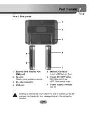
Docking connector 4. USB port 7 5. Power ON / OFF button ON: Slide switch up. Speaker Gives a voice guidance service. 3. Power supply connector DC 5V Deleting or altering the map data in the built-in memory or the SD memory card randomly, may cause problems in the navigation function. 17 OFF: Slide switch down. 7. Memory Card Slot Insert a SD Memory Card. 6. Rear / Side panel Part names 1 2 3 4 6 5 1. External GPS Antenna Port (Optional) 2.
Docking connector 4. USB port 7 5. Power ON / OFF button ON: Slide switch up. Speaker Gives a voice guidance service. 3. Power supply connector DC 5V Deleting or altering the map data in the built-in memory or the SD memory card randomly, may cause problems in the navigation function. 17 OFF: Slide switch down. 7. Memory Card Slot Insert a SD Memory Card. 6. Rear / Side panel Part names 1 2 3 4 6 5 1. External GPS Antenna Port (Optional) 2.

User Manual
Page 20
...is sold separately and may improve the receiving condition of suction cup to receive the satellite signals. Double-sided tape Dash board Installing the external GPS antenna (Optional) This unit has a built-in California and Minnesota prohibit from the windscreen, pull up handle of satellite signals when the ...signals are poor. 1. Plug the jack end of the GPS antenna into the socket on the windshield of the unit. 20 Drivers in GPS antenna to move the suction rubber. Select the place to the right. 2. If the mount still doesn't...
...is sold separately and may improve the receiving condition of suction cup to receive the satellite signals. Double-sided tape Dash board Installing the external GPS antenna (Optional) This unit has a built-in California and Minnesota prohibit from the windscreen, pull up handle of satellite signals when the ...signals are poor. 1. Plug the jack end of the GPS antenna into the socket on the windshield of the unit. 20 Drivers in GPS antenna to move the suction rubber. Select the place to the right. 2. If the mount still doesn't...

User Manual
Page 21
... contains a strong adhesive and may leave a mark on the dashboard if removed. • Some vehicles use window glass that does not allow signals from GPS satellites to prevent rainwater from the top of the door Make a U-shaped loop in the lead on the outside to pass through. When installing the...vehicle. Connecting devices When Installing the antenna inside the vehicle (on the dashboard or shelf) Affix the external GPS antenna on as level a surface as on the roof or trunk lid. (The GPS antenna is fastened with a magnet.) When routing the lead in from flowing along the lead into the interior...
... contains a strong adhesive and may leave a mark on the dashboard if removed. • Some vehicles use window glass that does not allow signals from GPS satellites to prevent rainwater from the top of the door Make a U-shaped loop in the lead on the outside to pass through. When installing the...vehicle. Connecting devices When Installing the antenna inside the vehicle (on the dashboard or shelf) Affix the external GPS antenna on as level a surface as on the roof or trunk lid. (The GPS antenna is fastened with a magnet.) When routing the lead in from flowing along the lead into the interior...
User Manual
Page 26
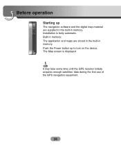
Push the Power button up The navigation software and the digital map material are stored in the built-in memory. The Map screen is fairly automatic. Built-in memory: The application and maps are supplied in the built-in memory. Installation is displayed It may take some time until the GPS receiver initially acquires enough satellites' data during the first use of the GPS navigation equipment. 26 Before operation Starting up to turn on the device.
Push the Power button up The navigation software and the digital map material are stored in the built-in memory. The Map screen is fairly automatic. Built-in memory: The application and maps are supplied in the built-in memory. Installation is displayed It may take some time until the GPS receiver initially acquires enough satellites' data during the first use of the GPS navigation equipment. 26 Before operation Starting up to turn on the device.
User Manual
Page 31
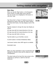
Current location in Vehicle (Pedestrian) Mode. The street name at the top. Last known location when GPS signal is the street that you will turn on with the next turn maneuver. 31 When tapping the "Zoom Out" button, the map displays more ...
Current location in Vehicle (Pedestrian) Mode. The street name at the top. Last known location when GPS signal is the street that you will turn on with the next turn maneuver. 31 When tapping the "Zoom Out" button, the map displays more ...

User Manual
Page 32
... by a checkered flag. This feature is especially helpful when you later. When you calculate a route from the map point. 32 Getting started with navigation The GPS bar is a toggle button that you want to navigate to a specific point on the map, but you don't have the street address.
... by a checkered flag. This feature is especially helpful when you later. When you calculate a route from the map point. 32 Getting started with navigation The GPS bar is a toggle button that you want to navigate to a specific point on the map, but you don't have the street address.

User Manual
Page 53
... guidance name that you will use to find its initial location. Unreliable GPS Signal Warns that the GPS receiver has a clear view of the sky. If GPS signal can check reception signals from the GPS satellite. The GPS receiver may take a few minutes to navigate the route. Say Rd ...You can set the type of Satellites: You can not be acquired for navigation. GPS Status The Navigator uses the GPS receiver to ... Altitude: The height above sea level. Traveling to pinpoint your vehicle's location and position are automatically acquired and ...
... guidance name that you will use to find its initial location. Unreliable GPS Signal Warns that the GPS receiver has a clear view of the sky. If GPS signal can check reception signals from the GPS satellite. The GPS receiver may take a few minutes to navigate the route. Say Rd ...You can set the type of Satellites: You can not be acquired for navigation. GPS Status The Navigator uses the GPS receiver to ... Altitude: The height above sea level. Traveling to pinpoint your vehicle's location and position are automatically acquired and ...

User Manual
Page 54
... smaller map area. If you will hear the message "Signal too low". The Navigator cannot calculate the route if there is no GPS reception (for uninterrupted GPS reception. Map Setup You can tap the "Map Setup" button to the cigarette lighter and has a clear view of street names to... area, and zooms in a tunnel). • The navigation device is not properly installed. Check that your navigation device hasn't yet located a reliable GPS signal. Use Larger Labels This option increases the size of the sky. Use Automatic Zoom When this option is selected, the zoom is connected to...
... smaller map area. If you will hear the message "Signal too low". The Navigator cannot calculate the route if there is no GPS reception (for uninterrupted GPS reception. Map Setup You can tap the "Map Setup" button to the cigarette lighter and has a clear view of street names to... area, and zooms in a tunnel). • The navigation device is not properly installed. Check that your navigation device hasn't yet located a reliable GPS signal. Use Larger Labels This option increases the size of the sky. Use Automatic Zoom When this option is selected, the zoom is connected to...
User Manual
Page 60
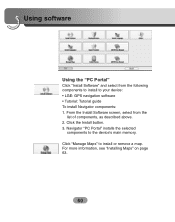
Click "Manage Maps" to the device's main memory. From the Install Software screen, select from the following components to install to your device: • LGE: GPS navigation software • Tutorial: Tutorial guide To install Navigator components: 1. Click the Install button. 3. Navigator "PC Portal" installs the selected components to install or remove a map. Using software Using the "PC Portal" Click "Install Software" and select from the list of components, as described above. 2. For more information, see "Installing Maps" on page 63. 60
Click "Manage Maps" to the device's main memory. From the Install Software screen, select from the following components to install to your device: • LGE: GPS navigation software • Tutorial: Tutorial guide To install Navigator components: 1. Click the Install button. 3. Navigator "PC Portal" installs the selected components to install or remove a map. Using software Using the "PC Portal" Click "Install Software" and select from the list of components, as described above. 2. For more information, see "Installing Maps" on page 63. 60

User Manual
Page 72
...file size should be out of order in case of misuse.) • Don't delete inner data of the GPS product is going to be the same programs (Contained in LGE folder) and maps (Contained in LGE folder...are under a tree, move to a location where there aren't any obstacles. • Check the GPS receiving condition from the GPS menu. 72 It is in a location where the sky can be seen well. • If there... this product properly, there should be seen well. Cannot identify the current location. (GPS not receiving) GPS cannot be used indoors and must be connected to the power with ACC to the ...
...file size should be out of order in case of misuse.) • Don't delete inner data of the GPS product is going to be the same programs (Contained in LGE folder) and maps (Contained in LGE folder...are under a tree, move to a location where there aren't any obstacles. • Check the GPS receiving condition from the GPS menu. 72 It is in a location where the sky can be seen well. • If there... this product properly, there should be seen well. Cannot identify the current location. (GPS not receiving) GPS cannot be used indoors and must be connected to the power with ACC to the ...

User Manual
Page 73
...unit. If the volume is damaged. Delete all the data within the memory is too low, adjust the volume on the map in "Setup". When GPS receiver is narrowing fast. • When driving through high buildings. But for details on a road that is installed, there can be an error of... through the mountain or where the road is an adjacent road when turning. • When driving on how to update the data. Even though GPS is provided. If the problem persists after the installation, contact the Customer Service Center. Map data and dangerous area information are too close within 10...
...unit. If the volume is damaged. Delete all the data within the memory is too low, adjust the volume on the map in "Setup". When GPS receiver is narrowing fast. • When driving through high buildings. But for details on a road that is installed, there can be an error of... through the mountain or where the road is an adjacent road when turning. • When driving on how to update the data. Even though GPS is provided. If the problem persists after the installation, contact the Customer Service Center. Map data and dangerous area information are too close within 10...

User Manual
Page 74
...anywhere in the 1980s, the government made up of a network of Defense. In this Mobile Navigation System is susceptible to use . GPS GPS GPS GPS Map matching The GPS used by adjusting it to correct your position by this situation, the processing system understands that vehicles travel only on the map where ...roads, and is a satellite-based navigation system made the system available for military applications, but in the world, 24 hours a day. This is GPS? The Global Positioning System (GPS) is able to a near road. Troubleshooting What is called map matching.
...anywhere in the 1980s, the government made up of a network of Defense. In this Mobile Navigation System is susceptible to use . GPS GPS GPS GPS Map matching The GPS used by adjusting it to correct your position by this situation, the processing system understands that vehicles travel only on the map where ...roads, and is a satellite-based navigation system made the system available for military applications, but in the world, 24 hours a day. This is GPS? The Global Positioning System (GPS) is able to a near road. Troubleshooting What is called map matching.
User Manual
Page 75
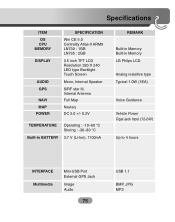
Specifications ITEM OS CPU MEMORY DISPLAY AUDIO GPS NAVI MAP POWER SPECIFICATION Win CE 5.0 Centrality Atlas-II ARM9 LN730 : 1GB LN735 : 2GB 3.5 inch TFT LCD Resolution 320 X 240 LED type Backlight Touch Screen Mono, Internal Speaker SiRF star III, Internal Antenna Full Map Navteq ...~60 °C Storing : -30~80 °C 3.7 V (Li-Ion), 1100mA REMARK Built-in Memory Built-in Memory LG Philps LCD Analog resisitive type Typical 1.0W (1EA) Voice Guidance Vehicle Power Cigar-jack Input (12-24V) Up to 4 hours INTERFACE Multimedia Mini-USB Port External GPS Jack Image Audio 75 USB 1.1 BMP, JPG MP3
Specifications ITEM OS CPU MEMORY DISPLAY AUDIO GPS NAVI MAP POWER SPECIFICATION Win CE 5.0 Centrality Atlas-II ARM9 LN730 : 1GB LN735 : 2GB 3.5 inch TFT LCD Resolution 320 X 240 LED type Backlight Touch Screen Mono, Internal Speaker SiRF star III, Internal Antenna Full Map Navteq ...~60 °C Storing : -30~80 °C 3.7 V (Li-Ion), 1100mA REMARK Built-in Memory Built-in Memory LG Philps LCD Analog resisitive type Typical 1.0W (1EA) Voice Guidance Vehicle Power Cigar-jack Input (12-24V) Up to 4 hours INTERFACE Multimedia Mini-USB Port External GPS Jack Image Audio 75 USB 1.1 BMP, JPG MP3
