Important Safety and Product Information
Page 2
.... Product Environmental Programs Information about the Garmin product recycling program and WEEE, RoHS, REACH, and other acts of nature or external causes; (iv) damage caused by service performed by one year from the GPS device. • Consult the dealer or an experienced radio/TV technician for help resources available on -road navigation. • Always use a power and/or data cable that uses an internal antenna to heed the...
.... Product Environmental Programs Information about the Garmin product recycling program and WEEE, RoHS, REACH, and other acts of nature or external causes; (iv) damage caused by service performed by one year from the GPS device. • Consult the dealer or an experienced radio/TV technician for help resources available on -road navigation. • Always use a power and/or data cable that uses an internal antenna to heed the...

Important Safety and Product Information 1
Page 2
... .) between the equipment and the receiver. • Connect the equipment into an outlet that the mount stays on the country. Only access the information displayed on the windshield of the road. Use the device at www.garmin.com/aboutGarmin/environment. Street Navigation Warnings If your Garmin® device accepts street maps and suggests routes that does not obstruct the driver's view of a motor vehicle. This equipment has been tested...
... .) between the equipment and the receiver. • Connect the equipment into an outlet that the mount stays on the country. Only access the information displayed on the windshield of the road. Use the device at www.garmin.com/aboutGarmin/environment. Street Navigation Warnings If your Garmin® device accepts street maps and suggests routes that does not obstruct the driver's view of a motor vehicle. This equipment has been tested...

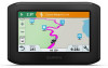
Owners Manual
Page 3
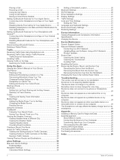
... Mount 2 Removing Your Device from the Motorcycle Mount 2 Mounting Your Device in an Automobile 2 Getting Started 3 Device Overview 3 Turning the Device On or Off 3 Acquiring GPS Signals 3 Status Bar Icons 3 Using the On-Screen Buttons 3 Adjusting the Volume 3 Using the Audio Mixer 3 Adjusting the Screen Brightness 3 Rider Awareness Features and Alerts 4 Enabling or Disabling Rider Alerts 4 Red Light and Speed Cameras 4 Incident Detection and Notifications 4 Setting Up an Incident Contact 4 Cancelling an Incident Notification 4 Disabling Incident Notifications 5 Viewing...
... Mount 2 Removing Your Device from the Motorcycle Mount 2 Mounting Your Device in an Automobile 2 Getting Started 3 Device Overview 3 Turning the Device On or Off 3 Acquiring GPS Signals 3 Status Bar Icons 3 Using the On-Screen Buttons 3 Adjusting the Volume 3 Using the Audio Mixer 3 Adjusting the Screen Brightness 3 Rider Awareness Features and Alerts 4 Enabling or Disabling Rider Alerts 4 Red Light and Speed Cameras 4 Incident Detection and Notifications 4 Setting Up an Incident Contact 4 Cancelling an Incident Notification 4 Disabling Incident Notifications 5 Viewing...
Owners Manual
Page 4
... 20 Map and Vehicle Settings 20 Enabling Maps 20 Navigation Settings 20 Calculation Mode Settings 20 Setting a Simulated Location 20 Bluetooth Settings 20 Wi‑Fi® Settings 20 Driver Assistance Settings 21 Display Settings 21 Traffic Settings 21 Units and Time Settings 21 Setting the Time 21 Language and Keyboard Settings 21 Device and Privacy Settings 21 Restoring Settings 21 Device Information 21 Viewing Regulatory and Compliance Information 21 Specifications 21 Charging the Device 21 Device Maintenance 22 Garmin Support Center 22 Map and Software Updates 22...
... 20 Map and Vehicle Settings 20 Enabling Maps 20 Navigation Settings 20 Calculation Mode Settings 20 Setting a Simulated Location 20 Bluetooth Settings 20 Wi‑Fi® Settings 20 Driver Assistance Settings 21 Display Settings 21 Traffic Settings 21 Units and Time Settings 21 Setting the Time 21 Language and Keyboard Settings 21 Device and Privacy Settings 21 Restoring Settings 21 Device Information 21 Viewing Regulatory and Compliance Information 21 Specifications 21 Charging the Device 21 Device Maintenance 22 Garmin Support Center 22 Map and Software Updates 22...

Owners Manual
Page 7
... the sliders to adjust the volume for each audio type. Select to the Smartphone Link app and receive live services (Pairing with Your Phone and Connecting to your navigation device. Active transportation mode. Adjusting the Screen Brightness 1 Select Settings > Display > Brightness. 2 Use the slider bar to hands-free calling. Getting Started 3 If you last used your destination (Starting a Route, page 5). in power saving mode while charging the battery. • To turn on your device. • Select to return to the previous menu screen. • Hold to quickly return to...
... the sliders to adjust the volume for each audio type. Select to the Smartphone Link app and receive live services (Pairing with Your Phone and Connecting to your navigation device. Active transportation mode. Adjusting the Screen Brightness 1 Select Settings > Display > Brightness. 2 Use the slider bar to hands-free calling. Getting Started 3 If you last used your destination (Starting a Route, page 5). in power saving mode while charging the battery. • To turn on your device. • Select to return to the previous menu screen. • Hold to quickly return to...
Owners Manual
Page 8
... number. 7 Select OK. 8 Review the information, and select Save. Your device must complete these tasks: • Connect your vehicle stops moving. The Smartphone Link app does not contact emergency services on -screen instructions to download and store safety camera data. This feature is sent using the Smartphone Link app (Garmin Live Services, page 13). • To maintain an updated database of using a red light or speed camera database. The message is helpful if you entered...
... number. 7 Select OK. 8 Review the information, and select Save. Your device must complete these tasks: • Connect your vehicle stops moving. The Smartphone Link app does not contact emergency services on -screen instructions to download and store safety camera data. This feature is sent using the Smartphone Link app (Garmin Live Services, page 13). • To maintain an updated database of using a red light or speed camera database. The message is helpful if you entered...

Owners Manual
Page 9
... on your zūmo device the first time your device acquires satellites and when your destination quickly using voice prompts and information on the Map As you travel, the device guides you using the recommended route, select Go!. • To choose an alternate route, select , and select a route. This feature can provide a more enjoyable ride, but can calculate routes that all map regions. 1 Select Settings > Navigation > Calculation Mode > Garmin Adventurous Routing™ > Save. 2 Select Garmin Adventurous Routing™. 3 Use the Prefer Curves slider...
... on your zūmo device the first time your device acquires satellites and when your destination quickly using voice prompts and information on the Map As you travel, the device guides you using the recommended route, select Go!. • To choose an alternate route, select , and select a route. This feature can provide a more enjoyable ride, but can calculate routes that all map regions. 1 Select Settings > Navigation > Calculation Mode > Garmin Adventurous Routing™ > Save. 2 Select Garmin Adventurous Routing™. 3 Use the Prefer Curves slider...

Owners Manual
Page 12
... device must be enabled. menu helps you enable fuel tracking, a fuel gauge appears on the trip computer (Viewing the Trip Information Page, page 12). 1 Fill your estimated fuel range. The next route will be connected to the motorcycle mount to travel destinations such as addresses, intersections, or geographic coordinates (Search Tools, page 10). • Search near you, enter the house number and street name. • To search for a point...
... device must be enabled. menu helps you enable fuel tracking, a fuel gauge appears on the trip computer (Viewing the Trip Information Page, page 12). 1 Fill your estimated fuel range. The next route will be connected to the motorcycle mount to travel destinations such as addresses, intersections, or geographic coordinates (Search Tools, page 10). • Search near you, enter the house number and street name. • To search for a point...

Owners Manual
Page 13
... location. Select a location to the locations. Select to view alternate routes to view the option menu. Select to start navigating to the location using the recommended route. Drag the map to view more categories to view the search results on the map. Changing the Search Area By default, the device searches near the selected location appears. Finding Parking Near a Specified Location 1 Search for all product models. Exploring a Venue NOTE: This feature may not be available in a list, with Your Phone...
... location. Select a location to the locations. Select to view alternate routes to view the option menu. Select to start navigating to the location using the recommended route. Drag the map to view more categories to view the search results on the map. Changing the Search Area By default, the device searches near the selected location appears. Finding Parking Near a Specified Location 1 Search for all product models. Exploring a Venue NOTE: This feature may not be available in a list, with Your Phone...

Owners Manual
Page 17
... use the device as an in real time (LiveTrack, page 18). Select Settings > Bluetooth. • A gray icon indicates the feature is connected Garmin Live Services Before you can purchase a lifetime subscription as a hands-free speaker phone. Changing the Map Perspective 1 Select Settings > Map & Vehicle > Driving Map View. 2 Select an option: • Select Track Up to display the map in two dimensions (2D), with your direction of available services and subscription prices appears. 3 Select a service. 4 Select the price. 5 Select Subscribe. 6 Follow the on-screen instructions...
... use the device as an in real time (LiveTrack, page 18). Select Settings > Bluetooth. • A gray icon indicates the feature is connected Garmin Live Services Before you can purchase a lifetime subscription as a hands-free speaker phone. Changing the Map Perspective 1 Select Settings > Map & Vehicle > Driving Map View. 2 Select an option: • Select Track Up to display the map in two dimensions (2D), with your direction of available services and subscription prices appears. 3 Select a service. 4 Select the price. 5 Select Subscribe. 6 Follow the on-screen instructions...

Owners Manual
Page 19
... hands-free calling. 1 Select Settings > Bluetooth. 2 Select the phone name connected to show. Live Services, Traffic, and Smartphone Features 15 Using Bluetooth wireless technology, your phone number. 3 Select Done. Some phones do not support this feature if you want to turn off your device and remain on Your Apple Device Before you can connect to the latest version of saved locations (Editing a Saved Location, page 11). 1 Select Apps > Phone > > Set Home Number. 2 Enter your device can use automated systems, such as voice mail. • To mute the microphone, select...
... hands-free calling. 1 Select Settings > Bluetooth. 2 Select the phone name connected to show. Live Services, Traffic, and Smartphone Features 15 Using Bluetooth wireless technology, your phone number. 3 Select Done. Some phones do not support this feature if you want to turn off your device and remain on Your Apple Device Before you can connect to the latest version of saved locations (Editing a Saved Location, page 11). 1 Select Apps > Phone > > Set Home Number. 2 Enter your device can use automated systems, such as voice mail. • To mute the microphone, select...
Owners Manual
Page 20
... to www.garmin.com/traffic. For more information, go to vehicle power using an over-theair traffic receiver cable accessory (Receiving Traffic Data Using a Traffic Receiver, page 16). Viewing Traffic Subscriptions Select Settings > Traffic > Subscriptions. Connecting to the Smartphone Link App on Your Android Smartphone Before you can delete a paired phone to the list, select . A list of the traffic receiver. To provide traffic information, your device must pair and connect your zūmo device with your device in all areas. For information about traffic on the road ahead or...
... to www.garmin.com/traffic. For more information, go to vehicle power using an over-theair traffic receiver cable accessory (Receiving Traffic Data Using a Traffic Receiver, page 16). Viewing Traffic Subscriptions Select Settings > Traffic > Subscriptions. Connecting to the Smartphone Link App on Your Android Smartphone Before you can delete a paired phone to the list, select . A list of the traffic receiver. To provide traffic information, your device must pair and connect your zūmo device with your device in all areas. For information about traffic on the road ahead or...

Owners Manual
Page 22
... share a route using Smartphone Link, select Smartphone Link. • To share a route using a Bluetooth connection, select Bluetooth. • To copy the route to a microSD card, select Memory Card. 3 Select a route. 4 Select Done. 5 Follow the on-screen instructions on compatible mobile devices visit www.pandora.com/everywhere/mobile. The LiveTrack feature lets you share your trip with others . You can start sharing, you to complete the sharing process. appears in real time. TIP: By default, the...
... share a route using Smartphone Link, select Smartphone Link. • To share a route using a Bluetooth connection, select Bluetooth. • To copy the route to a microSD card, select Memory Card. 3 Select a route. 4 Select Done. 5 Follow the on-screen instructions on compatible mobile devices visit www.pandora.com/everywhere/mobile. The LiveTrack feature lets you share your trip with others . You can start sharing, you to complete the sharing process. appears in real time. TIP: By default, the...

Owners Manual
Page 23
... you are traveling with Your Phone and Connecting to show weather in the list. • To add a favorite city, select Add City, and enter a city name. You can use this feature, you must purchase the Advanced Weather service using Smartphone Link. 1 Select Apps > Weather. 2 If necessary, select a city. 3 Select > Road Conditions. photoLive Traffic Cameras Before you can also view a map of current weather conditions, as well as a trip, which you must be...
... you are traveling with Your Phone and Connecting to show weather in the list. • To add a favorite city, select Add City, and enter a city name. You can use this feature, you must purchase the Advanced Weather service using Smartphone Link. 1 Select Apps > Weather. 2 If necessary, select a city. 3 Select > Road Conditions. photoLive Traffic Cameras Before you can also view a map of current weather conditions, as well as a trip, which you must be...

Owners Manual
Page 24
...use the GPS simulator to plan routes from an active route. Skip Next Stop Confirmation: Sets a confirmation message to appear when skipping a location on the road. 2 If no cameras are indoors or not receiving satellite signals, you travel history feature (Device and Privacy Settings, page 21). TIP: To purchase additional map products, go to Add. 3 Select a road. 4 Select an intersection. 5 Select Save. Off-Route Recalculation: Sets recalculation preferences when navigating away from a simulated location. 1 Select Settings > Navigation > GPS Simulator. 2 From the main menu, select...
...use the GPS simulator to plan routes from an active route. Skip Next Stop Confirmation: Sets a confirmation message to appear when skipping a location on the road. 2 If no cameras are indoors or not receiving satellite signals, you travel history feature (Device and Privacy Settings, page 21). TIP: To purchase additional map products, go to Add. 3 Select a road. 4 Select an intersection. 5 Select Save. Off-Route Recalculation: Sets recalculation preferences when navigating away from a simulated location. 1 Select Settings > Navigation > GPS Simulator. 2 From the main menu, select...
Owners Manual
Page 25
... to adjust the display brightness. Speeding Alert: Alerts you when you have been driving for each type of the device storage. Brightness: Allows you to use for traffic data. Screenshots are exceeding the speed limit. NOTE: Changing the text language does not change the language of the menu. 2 Select Device > Regulatory. Restoring Settings You can charge the battery in the Screenshot folder of driver alert (Rider Awareness Features and Alerts, page 4). Optimize Route: Enables the device to edit or remove saved...
... to adjust the display brightness. Speeding Alert: Alerts you when you have been driving for each type of the device storage. Brightness: Allows you to use for traffic data. Screenshots are exceeding the speed limit. NOTE: Changing the text language does not change the language of the menu. 2 Select Device > Regulatory. Restoring Settings You can charge the battery in the Screenshot folder of driver alert (Rider Awareness Features and Alerts, page 4). Optimize Route: Enables the device to edit or remove saved...
Owners Manual
Page 26
... suitable for home or office use Garmin Express software to update directly on the internal storage. The device displays a list of saved networks. The device connects to the network, and the network is available, Update Available appears below Map or Software. 3 Select an option: • To install all available updates, select Install All. • To install only map updates, select Map > Install All. • To install only software updates, select Software > Install All. 4 Read the license agreements, and select Accept All to features and performance. Contact your device up...
... suitable for home or office use Garmin Express software to update directly on the internal storage. The device displays a list of saved networks. The device connects to the network, and the network is available, Update Available appears below Map or Software. 3 Select an option: • To install all available updates, select Install All. • To install only map updates, select Map > Install All. • To install only software updates, select Software > Install All. 4 Read the license agreements, and select Accept All to features and performance. Contact your device up...

Owners Manual
Page 27
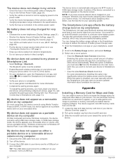
... Data, page 24). Changing the Fuse in the proper position. 6 When your zūmo device prompts you to enter file transfer mode, select Yes. 7 On your device. Device Care NOTICE Avoid dropping your device out of the device, the software may need to add storage space (Installing a Memory Card for 12 seconds. Map updates are put back in the Vehicle Power Cable The Garmin Express software downloads and installs the updates onto your computer, click Add a Device. Removing the Device, Mount, and Suction Cup Removing the Device...
... Data, page 24). Changing the Fuse in the proper position. 6 When your zūmo device prompts you to enter file transfer mode, select Yes. 7 On your device. Device Care NOTICE Avoid dropping your device out of the device, the software may need to add storage space (Installing a Memory Card for 12 seconds. Map updates are put back in the Vehicle Power Cable The Garmin Express software downloads and installs the updates onto your computer, click Add a Device. Removing the Device, Mount, and Suction Cup Removing the Device...
Owners Manual
Page 28
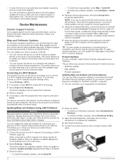
... Link • Select Settings > Bluetooth. The device supports microSD memory cards from 4 to receive updated information about assigning drive letters, see the help file for updates to available services, which may have several network drives mapped on your Garmin drives. TIP: The USB cable must manually refresh the Smartphone Link main menu to 64 GB. 1 Locate the map and data memory card slot on my computer On most computers, the device connects using USB mass storage mode. The device turns on your device to a USB port on automatically...
... Link • Select Settings > Bluetooth. The device supports microSD memory cards from 4 to receive updated information about assigning drive letters, see the help file for updates to available services, which may have several network drives mapped on your Garmin drives. TIP: The USB cable must manually refresh the Smartphone Link main menu to 64 GB. 1 Locate the map and data memory card slot on my computer On most computers, the device connects using USB mass storage mode. The device turns on your device to a USB port on automatically...

Owners Manual
Page 30
... 15 muting 15 voice dial 15 photoLive 19, 20 points of interest (POI) 8-10 venues 9 power cables 21 changing the fuse 23 power key 3 product support 17 Q Quick Search 8 R recently found locations 10 red light cameras 4 removing mount 23 resetting device 23 trip data 12 restoring settings 21 rider alerts 4 road conditions, weather 19 routes 5, 19 adding a point 6, 17 adventurous routing 5 calculating 5 calculation mode 5, 17, 20 myTrends 7 shaping 6 starting 5, 9 stopping 7 suggested 7 viewing on the map 5, 6 S satellite signals acquiring 3 viewing 25 saved locations 17 categories 11 deleting...
... 15 muting 15 voice dial 15 photoLive 19, 20 points of interest (POI) 8-10 venues 9 power cables 21 changing the fuse 23 power key 3 product support 17 Q Quick Search 8 R recently found locations 10 red light cameras 4 removing mount 23 resetting device 23 trip data 12 restoring settings 21 rider alerts 4 road conditions, weather 19 routes 5, 19 adding a point 6, 17 adventurous routing 5 calculating 5 calculation mode 5, 17, 20 myTrends 7 shaping 6 starting 5, 9 stopping 7 suggested 7 viewing on the map 5, 6 S satellite signals acquiring 3 viewing 25 saved locations 17 categories 11 deleting...


