Owners Manual
Page 35
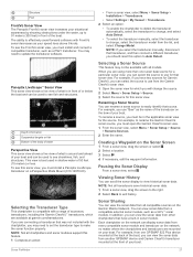
...and can be used to see shorelines, fish, and structures. You can display sonar data from the Garmin ClearVü sonar view. 1 Open the sonar view for which are mounted on the bow of the boat. Sonar Fishfinder 27 For example, if you can scroll the sonar ... type to make the sonar function properly. Creating a Waypoint on the network can view sonar data from another GPSMAP device and Garmin ClearVü transducer mounted at garmin.com/transducers. NOTE: Not all chartplotters and sonar modules support this sonar view, you must be available with a range of accessory...
...and can be used to see shorelines, fish, and structures. You can display sonar data from the Garmin ClearVü sonar view. 1 Open the sonar view for which are mounted on the bow of the boat. Sonar Fishfinder 27 For example, if you can scroll the sonar ... type to make the sonar function properly. Creating a Waypoint on the network can view sonar data from another GPSMAP device and Garmin ClearVü transducer mounted at garmin.com/transducers. NOTE: Not all chartplotters and sonar modules support this sonar view, you must be available with a range of accessory...
Owners Manual
Page 40
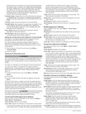
Setting the LiveVü and FrontVü Transducer Transmit Angle This feature is mounted. You can set the range to differentiate low intensity returns higher in the water column, but this causes a loss in the differentiation of the returns ... of the down view Panoptix transducer beam. This feature is the obligation of the vessel operator to view the forward distance from transmitting. This is mounted results in the water. Color Scheme: Sets the color palette. Bottom Style: Sets the style for the sonar return points. Install Depth: Sets the depth...
Setting the LiveVü and FrontVü Transducer Transmit Angle This feature is mounted. You can set the range to differentiate low intensity returns higher in the water column, but this causes a loss in the differentiation of the returns ... of the down view Panoptix transducer beam. This feature is the obligation of the vessel operator to view the forward distance from transmitting. This is mounted results in the water. Color Scheme: Sets the color palette. Bottom Style: Sets the style for the sonar return points. Install Depth: Sets the depth...
Owners Manual
Page 41
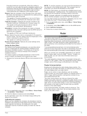
...deployed in many situations, such as the PS21-TR transducer. NOTE: For best results, you can calibrate the compass, the transducer must mount the transducer on . When the transmitted energy contacts a target, some of microwave energy as the SteadyCast™ heading sensor. This can... view, the forward range shifts by the distance you interpret the radar display more information about your compatible chartplotter to an optional Garmin marine radar, such as a GMR™ Fantom™ 6 radar or a GMR 24 xHD, you to view the forward distance from the trolling motor to compensate...
...deployed in many situations, such as the PS21-TR transducer. NOTE: For best results, you can calibrate the compass, the transducer must mount the transducer on . When the transmitted energy contacts a target, some of microwave energy as the SteadyCast™ heading sensor. This can... view, the forward range shifts by the distance you interpret the radar display more information about your compatible chartplotter to an optional Garmin marine radar, such as a GMR™ Fantom™ 6 radar or a GMR 24 xHD, you to view the forward distance from the trolling motor to compensate...

Owners Manual
Page 72
... has moved a large distance since the last time it can take several minutes to load onto the memory card. 11If you are applicable to the Garmin Marine Network. 1 Select Settings > System > Station Information > GRID™ Pairing > Add. 2 Select an action: • On the GRID remote input device, ... memory card from the chartplotter, and insert it to scroll through the images. 7 If necessary, select Menu > Start Slideshow. If it is mounted inside of the memory card. The software update can receive the GPS signal. 64 Appendix After loading the update onto the memory card, install the...
... has moved a large distance since the last time it can take several minutes to load onto the memory card. 11If you are applicable to the Garmin Marine Network. 1 Select Settings > System > Station Information > GRID™ Pairing > Add. 2 Select an action: • On the GRID remote input device, ... memory card from the chartplotter, and insert it to scroll through the images. 7 If necessary, select Menu > Start Slideshow. If it is mounted inside of the memory card. The software update can receive the GPS signal. 64 Appendix After loading the update onto the memory card, install the...

Flush Mount Template
Page 1
... right, to view page 2 in the product box. To print large templates, you need large enough paper and printer. NOTICE Garmin is not responsible for any damages or expenses resulting from a miscut mounting surface arising from a failure to follow these instructions. Use the template that came in the window below. 4 Verify that... ➎ and select a Page Size that is larger than the template ➍. If you do print the template, you must follow these instructions for printing a mounting template precisely. Printing a Mounting Template NOTICE It is not recommended that you print...
... right, to view page 2 in the product box. To print large templates, you need large enough paper and printer. NOTICE Garmin is not responsible for any damages or expenses resulting from a miscut mounting surface arising from a failure to follow these instructions. Use the template that came in the window below. 4 Verify that... ➎ and select a Page Size that is larger than the template ➍. If you do print the template, you must follow these instructions for printing a mounting template precisely. Printing a Mounting Template NOTICE It is not recommended that you print...
