Owners Manual
Page 4
...24 Setting a Tack and Gybe Delay 24 Enabling the Gybe Inhibitor 24 Heading Line and Angle Markers 24 Setting the Heading Line and Angle Markers 24 Sonar Fishfinder 24 Stopping the Transmission of Sonar Signals 24 Changing the Sonar View 24 Traditional Sonar View 24 Split-Frequency Sonar View 25 Split-Zoom Sonar View 25 Garmin...28 Recording the Sonar Display 28 Stopping the Sonar Recording 28 Deleting a Sonar Recording 28 Playing Sonar Recordings 28 Traditional, Garmin ClearVü, and SideVü Sonar Setup 28 Setting the Zoom Level on the Sonar Screen 28 Setting the Scroll ...
...24 Setting a Tack and Gybe Delay 24 Enabling the Gybe Inhibitor 24 Heading Line and Angle Markers 24 Setting the Heading Line and Angle Markers 24 Sonar Fishfinder 24 Stopping the Transmission of Sonar Signals 24 Changing the Sonar View 24 Traditional Sonar View 24 Split-Frequency Sonar View 25 Split-Zoom Sonar View 25 Garmin...28 Recording the Sonar Display 28 Stopping the Sonar Recording 28 Deleting a Sonar Recording 28 Playing Sonar Recordings 28 Traditional, Garmin ClearVü, and SideVü Sonar Setup 28 Setting the Zoom Level on the Sonar Screen 28 Setting the Scroll ...
Owners Manual
Page 21
...the tide. Heading: Sets the projected heading time for a detailed view of the bottom. Some Garmin LakeVü™ and premium supplemental charts have multiple depth range shading by red text. Spot ...the laylines. Sonar Imagery: Shows sonar imagery to show user data, such as an AIS receiver, radar, or VHF radio. This feature is a line drawn on the chart and opens the list ... map presentation for a detailed view of travel (Setting the Heading Line and Angle Markers, page 24). Fishing Contours: Sets the zoom level for AIS- Active Tracks: Shows the active track on the...
...the tide. Heading: Sets the projected heading time for a detailed view of the bottom. Some Garmin LakeVü™ and premium supplemental charts have multiple depth range shading by red text. Spot ...the laylines. Sonar Imagery: Shows sonar imagery to show user data, such as an AIS receiver, radar, or VHF radio. This feature is a line drawn on the chart and opens the list ... map presentation for a detailed view of travel (Setting the Heading Line and Angle Markers, page 24). Fishing Contours: Sets the zoom level for AIS- Active Tracks: Shows the active track on the...

Owners Manual
Page 32
... inhibitor does not prevent you must have a compatible Panoptix transducer connected. Sonar Fishfinder When properly connected to a transducer, your needs, go to garmin.com/transducers. For more views, a split-zoom view, and a split-frequency view that displays two different frequencies. You can customize the settings...a tack or gybe, and information about which transducer is an extension drawn on the map from the right to the left. 24 Sonar Fishfinder Heading Line and Angle Markers The heading line is best for casting or finding reference points. Different sonar views can ...
... inhibitor does not prevent you must have a compatible Panoptix transducer connected. Sonar Fishfinder When properly connected to a transducer, your needs, go to garmin.com/transducers. For more views, a split-zoom view, and a split-frequency view that displays two different frequencies. You can customize the settings...a tack or gybe, and information about which transducer is an extension drawn on the map from the right to the left. 24 Sonar Fishfinder Heading Line and Angle Markers The heading line is best for casting or finding reference points. Different sonar views can ...
Owners Manual
Page 41
..., or rain cloud. The more information about your compatible chartplotter to an optional Garmin marine radar, such as a GMR™ Fantom™ 6 radar or a GMR 24 xHD, you should use the radar, the better you will become at close range when the radar is turned on the shaft far enough away from the transducer to enable the...
..., or rain cloud. The more information about your compatible chartplotter to an optional Garmin marine radar, such as a GMR™ Fantom™ 6 radar or a GMR 24 xHD, you should use the radar, the better you will become at close range when the radar is turned on the shaft far enough away from the transducer to enable the...
Owners Manual
Page 73
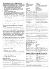
...one of the power issue. • Make sure the power source is generating power. Most often this several grid formats. power usage at 10 Vdc 24 W Typical current draw at 12 Vdc 2.3 A NMEA 2000 LEN @ 9 Vdc 2 NMEA 2000 draw Max. waypoints 5,000 Max. card size HTML...near the map key. 2 Select Settings > Preferences > Units. 3 Select the correct map datum and position format settings. 4 Create the waypoint again. Contacting Garmin Support • Go to 32 Vdc Max. active track points 50,000 points, 50 saved tracks Wireless frequency 2.4 GHz @ 17.6 dBm nominal Memory card ...
...one of the power issue. • Make sure the power source is generating power. Most often this several grid formats. power usage at 10 Vdc 24 W Typical current draw at 12 Vdc 2.3 A NMEA 2000 LEN @ 9 Vdc 2 NMEA 2000 draw Max. waypoints 5,000 Max. card size HTML...near the map key. 2 Select Settings > Preferences > Units. 3 Select the correct map datum and position format settings. 4 Create the waypoint again. Contacting Garmin Support • Go to 32 Vdc Max. active track points 50,000 points, 50 saved tracks Wireless frequency 2.4 GHz @ 17.6 dBm nominal Memory card ...

Owners Manual
Page 76
...15 appearance 12-14 details 9 fishing 8 layers 12, 13 measuring distance 9 navigation 8-10 quickdraw 14, 15 radar 14 settings 12 symbols 8 updating 7 circuits 47 clock 60 alarm 60 collision alarm 11, 61 color mode ... and gybing H heading 39 adjusting 39 heading hold 23 holding 39 line 12, 24 Shadow Drive 39 help. See charts marine services 17 mark location 17 MARPA acquiring ...44, 46 status alarm 46, 60 synchronizing with actual fuel 46 Fusion PartyBus 49 G Garmin ClearVü 25 Garmin Marine Network 59 Garmin product support. See product support home screen 2 customizing 3, 4 I images 3, 64 ...
...15 appearance 12-14 details 9 fishing 8 layers 12, 13 measuring distance 9 navigation 8-10 quickdraw 14, 15 radar 14 settings 12 symbols 8 updating 7 circuits 47 clock 60 alarm 60 collision alarm 11, 61 color mode ... and gybing H heading 39 adjusting 39 heading hold 23 holding 39 line 12, 24 Shadow Drive 39 help. See charts marine services 17 mark location 17 MARPA acquiring ...44, 46 status alarm 46, 60 synchronizing with actual fuel 46 Fusion PartyBus 49 G Garmin ClearVü 25 Garmin Marine Network 59 Garmin product support. See product support home screen 2 customizing 3, 4 I images 3, 64 ...
Owners Manual
Page 77
... 2 screen brightness 5 locking 1, 5 unlocking 1 screenshots 64 capturing 64 settings 16, 57, 58 radar display 37 system information 58 Shadow Drive, enabling 39 sharing data 62 shoreline distance 20, 58 shortcuts 42...29 cone 14 depth 28 depth scale 29 frequencies 30, 31 FrontVü 27 gain 28 Garmin ClearVü 25 interference 29 measuring distances 25 noise 28 numbers 4 Panoptix 25-27, ...See product support suspended targets 14 symbols 10 system information 58, 63 T tacking and gybing 24 heading hold 24 wind hold 23 tank level sensors 45 targeting 35 temperature log 47 tide stations 10, 48 ...
... 2 screen brightness 5 locking 1, 5 unlocking 1 screenshots 64 capturing 64 settings 16, 57, 58 radar display 37 system information 58 Shadow Drive, enabling 39 sharing data 62 shoreline distance 20, 58 shortcuts 42...29 cone 14 depth 28 depth scale 29 frequencies 30, 31 FrontVü 27 gain 28 Garmin ClearVü 25 interference 29 measuring distances 25 noise 28 numbers 4 Panoptix 25-27, ...See product support suspended targets 14 symbols 10 system information 58, 63 T tacking and gybing 24 heading hold 24 wind hold 23 tank level sensors 45 targeting 35 temperature log 47 tide stations 10, 48 ...

Owners Manual
Page 78
... wave information 53 winds 53 Wi‑Fi 5 Wi‑Fi technology 7 wind, rose 13 wind angle graph 47 wind gauges 46 wind hold 23, 24 adjusting 24 wind sensor 7 wind speed graph 47 wireless devices 7, 47, 55, 56 connecting a wireless device 7, 8 connecting to a wireless device 5 network configuration 7 Z zoom chart 8 sonar 28...
... wave information 53 winds 53 Wi‑Fi 5 Wi‑Fi technology 7 wind, rose 13 wind angle graph 47 wind gauges 46 wind hold 23, 24 adjusting 24 wind sensor 7 wind speed graph 47 wireless devices 7, 47, 55, 56 connecting a wireless device 7, 8 connecting to a wireless device 5 network configuration 7 Z zoom chart 8 sonar 28...