aera 660 Pilot s Guide
Page 6
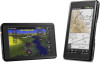
... remains current. Warnings, Cautions & Notes WARNING: When installing the aera™, place the unit so it does not obstruct the field of the terrain data. WARNING: Navigation and terrain separation must be updated regularly in nature and should not be predicated upon as a primary... terrain function. WARNING: The altitude calculated by the GPS and GLONASS receivers is obtained from the altitude displayed by pressure altimeters. Garmin aera 660 Pilot's Guide 190-02017-20 Rev. Terrain data is geometric height above Mean Sea Level and could vary significantly from third party...
... remains current. Warnings, Cautions & Notes WARNING: When installing the aera™, place the unit so it does not obstruct the field of the terrain data. WARNING: Navigation and terrain separation must be updated regularly in nature and should not be predicated upon as a primary... terrain function. WARNING: The altitude calculated by the GPS and GLONASS receivers is obtained from the altitude displayed by pressure altimeters. Garmin aera 660 Pilot's Guide 190-02017-20 Rev. Terrain data is geometric height above Mean Sea Level and could vary significantly from third party...

aera 660 Pilot s Guide
Page 9
NOTE: Use of polarized eyewear may not be updated outside of normal business hours. For questions or additional information, please refer to appear dim or blank. A Garmin aera 660 Pilot's Guide Warnings, Cautions & Notes NOTE: This product, its packaging, and its components contain chemicals known to the State of TFR data. 190-02017-20 ...
NOTE: Use of polarized eyewear may not be updated outside of normal business hours. For questions or additional information, please refer to appear dim or blank. A Garmin aera 660 Pilot's Guide Warnings, Cautions & Notes NOTE: This product, its packaging, and its components contain chemicals known to the State of TFR data. 190-02017-20 ...
aera 660 Pilot s Guide
Page 15
A Garmin aera 660 Pilot's Guide iii Table of Contents SECTION 5 ADDITIONAL FEATURES 113 5.1 SafeTaxi...113 SafeTaxi Cycle Number and Revision 114 5.2 Airport Directory Data 114 Fuel Prices...116 ... a Computer 125 Managing Files...126 MicroSD™ Card Use (Optional 127 Database Types...128 Database Purchase, Installation, and Updates 130 Appendix D: Installation and Interfacing 133 Mounting the aera in the Aircraft 133 Connecting to a Garmin VHF Comm Radio 137 Information about USB Drivers 139 Interfacing...139 Connecting to a GTX 330 Mode S Transponder 141...
A Garmin aera 660 Pilot's Guide iii Table of Contents SECTION 5 ADDITIONAL FEATURES 113 5.1 SafeTaxi...113 SafeTaxi Cycle Number and Revision 114 5.2 Airport Directory Data 114 Fuel Prices...116 ... a Computer 125 Managing Files...126 MicroSD™ Card Use (Optional 127 Database Types...128 Database Purchase, Installation, and Updates 130 Appendix D: Installation and Interfacing 133 Mounting the aera in the Aircraft 133 Connecting to a Garmin VHF Comm Radio 137 Information about USB Drivers 139 Interfacing...139 Connecting to a GTX 330 Mode S Transponder 141...
aera 660 Pilot s Guide
Page 85
...destination is reached and the system is changed by entering waypoints one at a time and becomes the active flight plan. An option menu appears. A Garmin aera 660 Pilot's Guide 69 Appendices Index Or: a) From the Main Menu, touch Flight Plan List. c) Touch Edit. 190-02017-20 Rev. Changing ...plan by touching the Data Field Buttons at the top of the flight plan. Up to 300 waypoints each can be changed or updated, the aera automatically updates the information if the procedure has not been modified. DATA FIELDS The Active and Saved Flight Plan Data Fields can be activated ...
...destination is reached and the system is changed by entering waypoints one at a time and becomes the active flight plan. An option menu appears. A Garmin aera 660 Pilot's Guide 69 Appendices Index Or: a) From the Main Menu, touch Flight Plan List. c) Touch Edit. 190-02017-20 Rev. Changing ...plan by touching the Data Field Buttons at the top of the flight plan. Up to 300 waypoints each can be changed or updated, the aera automatically updates the information if the procedure has not been modified. DATA FIELDS The Active and Saved Flight Plan Data Fields can be activated ...

aera 660 Pilot s Guide
Page 98
...Page,or the Data Link Page from the display. Weather products are updated regularly and may not contain new weather data. If, for clear air As Available Broadcast Interval (Minutes) 15 2.5 Appendices Index 82 Garmin aera 660 Pilot's Guide 190-02017-20 Rev. If more than half of the... expiration time has elapsed, the color of a product age when a product has expired. The broadcast interval represents the interval at which weather data is updated or new content is received ...
...Page,or the Data Link Page from the display. Weather products are updated regularly and may not contain new weather data. If, for clear air As Available Broadcast Interval (Minutes) 15 2.5 Appendices Index 82 Garmin aera 660 Pilot's Guide 190-02017-20 Rev. If more than half of the... expiration time has elapsed, the color of a product age when a product has expired. The broadcast interval represents the interval at which weather data is updated or new content is received ...

aera 660 Pilot s Guide
Page 99
... images can be used for long-range planning purposes only. A Garmin aera 660 Pilot's Guide 83 Overview Navigation Flight Planning Hazard Avoidance Additional Features Hazard Avoidance FIS-B Products METAR TAF AIRMET SIGMET PIREP Winds and Temperatures Aloft NOTAM (D)/FDC (Including TFRs) Expiration Time Update Interval (Minutes) Broadcast Interval (Minutes) 8 hours 1 minute (where available), As...
... images can be used for long-range planning purposes only. A Garmin aera 660 Pilot's Guide 83 Overview Navigation Flight Planning Hazard Avoidance Additional Features Hazard Avoidance FIS-B Products METAR TAF AIRMET SIGMET PIREP Winds and Temperatures Aloft NOTAM (D)/FDC (Including TFRs) Expiration Time Update Interval (Minutes) Broadcast Interval (Minutes) 8 hours 1 minute (where available), As...
aera 660 Pilot s Guide
Page 103
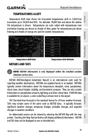
... pointer. METAR and TAF data can be viewed by selecting the METAR flag with temperatures near and below freezing are updated hourly or as raw or decoded text. 190-02017-20 Rev. A Garmin aera 660 Pilot's Guide 87 Appendices Index For altitudes 18,000 feet and above freezing and shades of the same code...
... pointer. METAR and TAF data can be viewed by selecting the METAR flag with temperatures near and below freezing are updated hourly or as raw or decoded text. 190-02017-20 Rev. A Garmin aera 660 Pilot's Guide 87 Appendices Index For altitudes 18,000 feet and above freezing and shades of the same code...

aera 660 Pilot s Guide
Page 119
...to thirteen seconds. In this case, a GBT will only be configured to the ADS-B participating aircraft. A Garmin aera 660 Pilot's Guide 103 The squitter of some 1090 ES transponders, including the Garmin GTX 23ES, must be broadcast by ATC surveillance radar. FIS-B service is provided continuously, but ADS-R including ... of a GBT. Aircraft operating outside of the ADS-B participating aircraft is derived from ATC surveillance radar data, TIS-B traffic position updates typically occur every three to /from any ADS-B Out aircraft within the GBT's defined service volume.
...to thirteen seconds. In this case, a GBT will only be configured to the ADS-B participating aircraft. A Garmin aera 660 Pilot's Guide 103 The squitter of some 1090 ES transponders, including the Garmin GTX 23ES, must be broadcast by ATC surveillance radar. FIS-B service is provided continuously, but ADS-R including ... of a GBT. Aircraft operating outside of the ADS-B participating aircraft is derived from ATC surveillance radar data, TIS-B traffic position updates typically occur every three to /from any ADS-B Out aircraft within the GBT's defined service volume.
aera 660 Pilot s Guide
Page 130
...current when the SafeTaxi name and expiration date are shown in white. A Index SafeTaxi is displayed on the Waypoint Page. 114 Garmin aera 660 Pilot's Guide 190-02017-20 Rev. The database initialization shows the SafeTaxi database is displayed on the Waypoint Page. Refer to ... airport statistics such as AC-U-KWIK are current, out of date, or not available. SAFETAXI CYCLE NUMBER AND REVISION SafeTaxi database is updated on updating the SafeTaxi database. Additional Features Overview Navigation Enabling/disabling SafeTaxi: 1) From the Main Menu, touch Map > Menu > Set Up ...
...current when the SafeTaxi name and expiration date are shown in white. A Index SafeTaxi is displayed on the Waypoint Page. 114 Garmin aera 660 Pilot's Guide 190-02017-20 Rev. The database initialization shows the SafeTaxi database is displayed on the Waypoint Page. Refer to ... airport statistics such as AC-U-KWIK are current, out of date, or not available. SAFETAXI CYCLE NUMBER AND REVISION SafeTaxi database is updated on updating the SafeTaxi database. Additional Features Overview Navigation Enabling/disabling SafeTaxi: 1) From the Main Menu, touch Map > Menu > Set Up ...
aera 660 Pilot s Guide
Page 144
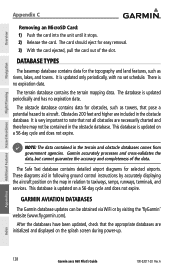
..., lakes, and towns. There is updated periodically and has no expiration date. The database is no set schedule. The obstacle database contains data for easy removal. 3) With the card ejected, pull the card out of the data. Appendices Index 128 Garmin aera 660 Pilot's Guide 190-02017-20 Rev.... A It is updated on a 56-day cycle and does not expire. DATABASE TYPES The basemap database contains data for selected airports. It...
..., lakes, and towns. There is updated periodically and has no expiration date. The database is no set schedule. The obstacle database contains data for easy removal. 3) With the card ejected, pull the card out of the data. Appendices Index 128 Garmin aera 660 Pilot's Guide 190-02017-20 Rev.... A It is updated on a 56-day cycle and does not expire. DATABASE TYPES The basemap database contains data for selected airports. It...
aera 660 Pilot s Guide
Page 145
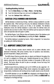
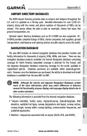
...differences in regionalized options. There are also supported. A Garmin aera 660 Pilot's Guide 129 Optional airport directory databases such as AC-U-KWIK are two navigation database products available: the Garmin Navigation database containing coverage for North America (expanded coverage...once the databases are available online (www.fly.garmin. NAVIGATION DATABASE The aera 660 includes an internal navigation database that provides location and facility information for over 5,300 U.S. The following information is updated on airports and heliports throughout the U.S. This ...
...differences in regionalized options. There are also supported. A Garmin aera 660 Pilot's Guide 129 Optional airport directory databases such as AC-U-KWIK are two navigation database products available: the Garmin Navigation database containing coverage for North America (expanded coverage...once the databases are available online (www.fly.garmin. NAVIGATION DATABASE The aera 660 includes an internal navigation database that provides location and facility information for over 5,300 U.S. The following information is updated on airports and heliports throughout the U.S. This ...

aera 660 Pilot s Guide
Page 146
...After performing a navigation database update, verify all flight plan(s) (routes) are available online (www.fly.garmin.com). If there is an obsolete aviation point in a saved route, the route is available from the aera 660 via WiFi. Appendices Index 130 Garmin aera 660 Pilot's Guide 190-02017...B, Class C, Control Zones, SUAs, and MOAs), controlling agency, and vertical boundaries. • FSS-Flight Service Stations. * Symbology used on the aera 660: a) From the Main Menu, touch Tools > Setup > Wi-Fi > On. c) Touch the desired network to a WiFi network on a sectional chart. ...
...After performing a navigation database update, verify all flight plan(s) (routes) are available online (www.fly.garmin.com). If there is an obsolete aviation point in a saved route, the route is available from the aera 660 via WiFi. Appendices Index 130 Garmin aera 660 Pilot's Guide 190-02017...B, Class C, Control Zones, SUAs, and MOAs), controlling agency, and vertical boundaries. • FSS-Flight Service Stations. * Symbology used on the aera 660: a) From the Main Menu, touch Tools > Setup > Wi-Fi > On. c) Touch the desired network to a WiFi network on a sectional chart. ...

aera 660 Pilot s Guide
Page 155
... for NMEA 0183, version 3.01 output: GPRMC, GPGGA, GPGSA, GPGSV, GPGLL, GPBOD, GPRTE, and GPWPL. The frequency is available from the list. A Garmin aera 660 Pilot's Guide 139 USB driver updates can also directly tune a standby frequency. INTERFACING The following are now available on the radio: • Remote frequency lists for NMEA 0183, version...
... for NMEA 0183, version 3.01 output: GPRMC, GPGGA, GPGSA, GPGSV, GPGLL, GPBOD, GPRTE, and GPWPL. The frequency is available from the list. A Garmin aera 660 Pilot's Guide 139 USB driver updates can also directly tune a standby frequency. INTERFACING The following are now available on the radio: • Remote frequency lists for NMEA 0183, version...
aera 660 Pilot s Guide
Page 159
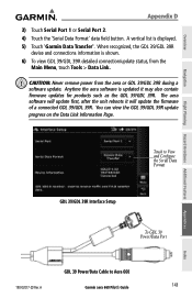
A Garmin aera 660 Pilot's Guide 143 Index When recognized, the GDL 39/GDL 39R device and connections information is shown. 6) To view GDL 39/GDL 39R detailed connection/update status, from the aera or GDL 39/GDL 39R during a software update. CAUTION: Never remove power from the Main Menu, touch Tools ...39 Power/Data Port GDL 39 Power/Data Cable to Aera 660 190-02017-20 Rev. Overview Appendix D 3) Touch Serial Port 1 or Serial Port 2. 4) Touch the 'Serial Data Format' data field button. A vertical list is updated it will update the firmware of a connected GDL 39/GDL 39R.
A Garmin aera 660 Pilot's Guide 143 Index When recognized, the GDL 39/GDL 39R device and connections information is shown. 6) To view GDL 39/GDL 39R detailed connection/update status, from the aera or GDL 39/GDL 39R during a software update. CAUTION: Never remove power from the Main Menu, touch Tools ...39 Power/Data Port GDL 39 Power/Data Cable to Aera 660 190-02017-20 Rev. Overview Appendix D 3) Touch Serial Port 1 or Serial Port 2. 4) Touch the 'Serial Data Format' data field button. A vertical list is updated it will update the firmware of a connected GDL 39/GDL 39R.
aera 660 Pilot s Guide
Page 161
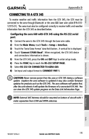
CAUTION: Never remove power from the GTX 345 as the GTX 345. Appendices Index 190-02017-20 Rev. A Garmin aera 660 Pilot's Guide 145 The aera must be mounted on the Data Link Information Page. When recognized, the GTX 345 device and connections information is shown. 5) ... 7) Select RS-232 CH CONNECTED TO AERA 660. 8) Set input and output format to the GTX 345 through Bluetooth or the aera 660 bare wire cable (P/N 01012373-01). You can view the GTX 345 update progress on bottom of a connected GTX 345. Configuring the aera 660 with 1 meter separation from the GTX ...
CAUTION: Never remove power from the GTX 345 as the GTX 345. Appendices Index 190-02017-20 Rev. A Garmin aera 660 Pilot's Guide 145 The aera must be mounted on the Data Link Information Page. When recognized, the GTX 345 device and connections information is shown. 5) ... 7) Select RS-232 CH CONNECTED TO AERA 660. 8) Set input and output format to the GTX 345 through Bluetooth or the aera 660 bare wire cable (P/N 01012373-01). You can view the GTX 345 update progress on bottom of a connected GTX 345. Configuring the aera 660 with 1 meter separation from the GTX ...

aera 660 Pilot s Guide
Page 167
... on the Navigation Map. Due to 3,500 feet above the requesting aircraft. TAS/TCAS uses an airborne interrogator with a half-second update rate, while TIS-A utilizes the terminal Mode-S ground interrogator and accompanying data link to accurately depict all of the traffic within a ... traffic notification. TIS-A VS. The Traffic Information Service (TIS-A) provides traffic advisory information to see and avoid other aircraft. A Garmin aera 660 Pilot's Guide 151 WARNING: Do not rely solely upon the display of surveillance data. The traffic display does not provide collision avoidance...
... on the Navigation Map. Due to 3,500 feet above the requesting aircraft. TAS/TCAS uses an airborne interrogator with a half-second update rate, while TIS-A utilizes the terminal Mode-S ground interrogator and accompanying data link to accurately depict all of the traffic within a ... traffic notification. TIS-A VS. The Traffic Information Service (TIS-A) provides traffic advisory information to see and avoid other aircraft. A Garmin aera 660 Pilot's Guide 151 WARNING: Do not rely solely upon the display of surveillance data. The traffic display does not provide collision avoidance...

aera 660 Pilot s Guide
Page 177
... the range for airspeed on the directional gyro or compass into the 'Heading' field. The maximum speed is automatically updated if you exceed this figure. Restoring E6B calculator defaults: From the Main Menu, touch Tools > E6B > Menu > Restore Default. A Garmin aera 660 Pilot's Guide 161 Tail Wind, Wind From, and Wind Speed are calculated.
... the range for airspeed on the directional gyro or compass into the 'Heading' field. The maximum speed is automatically updated if you exceed this figure. Restoring E6B calculator defaults: From the Main Menu, touch Tools > E6B > Menu > Restore Default. A Garmin aera 660 Pilot's Guide 161 Tail Wind, Wind From, and Wind Speed are calculated.


