Owner's Manual
Page 3
... questions or comments regarding the use of the eTrex you register your eTrex purchase? • Notification of Product Updates • Notification of New Products Connect to understand the operating features of your new eTrex, take the time to read through this Owner's Manual to our web site (www.garmin.com) and look for choosing the Garmin eTrex. Introduction Welcome To get the...
... questions or comments regarding the use of the eTrex you register your eTrex purchase? • Notification of Product Updates • Notification of New Products Connect to understand the operating features of your new eTrex, take the time to read through this Owner's Manual to our web site (www.garmin.com) and look for choosing the Garmin eTrex. Introduction Welcome To get the...
Owner's Manual
Page 5
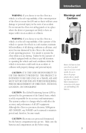
... PRECISE MEASUREMENT OF DIRECTION, DISTANCE, LOCATION, OR TOPOGRAPHY. Make sure the batteries and compartment are protected if immersed, but the battery compartment may get wet. Introduction WARNING: If you choose to use the eTrex in a vehicle, it is the sole responsibility of the owner/operator of the eTrex to secure the GPS unit so that it for its accuracy and maintenance. Do not mount the eTrex...
... PRECISE MEASUREMENT OF DIRECTION, DISTANCE, LOCATION, OR TOPOGRAPHY. Make sure the batteries and compartment are protected if immersed, but the battery compartment may get wet. Introduction WARNING: If you choose to use the eTrex in a vehicle, it is the sole responsibility of the owner/operator of the eTrex to secure the GPS unit so that it for its accuracy and maintenance. Do not mount the eTrex...
Owner's Manual
Page 7
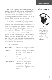
... are located on what you to navigate back to 50 waypoints in battery save mode. Allows you to navigate a course of up to this point any time you can provide one -handed operation that won't obstruct your GPS provides other forms of basic navigation, not entirely replace them. 5 From these basic features, your path in GPS antenna and five user-buttons. Other features include: Waypoints: Tracks: Route: Trip Computer: 500 with GPS you...
... are located on what you to navigate back to 50 waypoints in battery save mode. Allows you to navigate a course of up to this point any time you can provide one -handed operation that won't obstruct your GPS provides other forms of basic navigation, not entirely replace them. 5 From these basic features, your path in GPS antenna and five user-buttons. Other features include: Waypoints: Tracks: Route: Trip Computer: 500 with GPS you...
Owner's Manual
Page 10
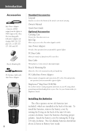
... using a background map and downloading them to a belt.. Bicycle Mounting Kit PC Interface Cable with power adapters for Garmin VHF 720, 725, and 725e, or GPS 170, 175, 190, and 195. Owner's Manual Quick Start Guide Optional Accessories Carrying Case Protects the eTrex when not in 'Battery Save' mode. Attach the battery cover by turning the D-ring on two AA batteries (not included), which are installed at the back of waypoints and routes...
... using a background map and downloading them to a belt.. Bicycle Mounting Kit PC Interface Cable with power adapters for Garmin VHF 720, 725, and 725e, or GPS 170, 175, 190, and 195. Owner's Manual Quick Start Guide Optional Accessories Carrying Case Protects the eTrex when not in 'Battery Save' mode. Attach the battery cover by turning the D-ring on two AA batteries (not included), which are installed at the back of waypoints and routes...
Owner's Manual
Page 11
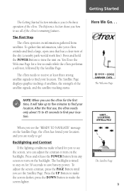
... to save battery power. Press and release the POWER Button from satellites. Press the UP Button to make the screen darker, press the DOWN Button to find your location. The Reference Section shows you how to use , the eTrex needs only about 15 to 45 seconds to make it will take your location. After the first use all of the satellite signals, and the satellite tracking status. Backlighting and...
... to save battery power. Press and release the POWER Button from satellites. Press the UP Button to make the screen darker, press the DOWN Button to find your location. The Reference Section shows you how to use , the eTrex needs only about 15 to 45 seconds to make it will take your location. After the first use all of the satellite signals, and the satellite tracking status. Backlighting and...
Owner's Manual
Page 12
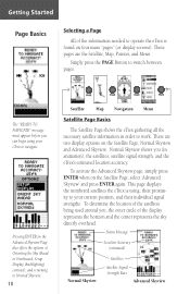
... are the Satellite, Map, Pointer, and Menu. Status Message Location Accuracy (estimated) Normal Skyview Satellites Satellite Signal Strength Bars Advanced Skyview Getting Started Page Basics Selecting a Page All of the information needed to operate the eTrex is using your current position, and their proximity to switch between pages. The "READY TO NAVIGATE" message must appear before you , the outer circle of Orienting the Sky Ahead or Northward, Setup Display (backlighting/ contrast...
... are the Satellite, Map, Pointer, and Menu. Status Message Location Accuracy (estimated) Normal Skyview Satellites Satellite Signal Strength Bars Advanced Skyview Getting Started Page Basics Selecting a Page All of the information needed to operate the eTrex is using your current position, and their proximity to switch between pages. The "READY TO NAVIGATE" message must appear before you , the outer circle of Orienting the Sky Ahead or Northward, Setup Display (backlighting/ contrast...

Owner's Manual
Page 13
... always displayed in the "Discovering GPS Navigation" section. The North Pointer always shows you travel (the animated figure "walks") and leaves a "trail" (track log). We will show you can see your entire trip, you how to record your location by pressing and holding the UP Button to 800 miles. The Map Page showing different symbols and waypoints. 11 To make sure you can change the map...
... always displayed in the "Discovering GPS Navigation" section. The North Pointer always shows you travel (the animated figure "walks") and leaves a "trail" (track log). We will show you can see your entire trip, you how to record your location by pressing and holding the UP Button to 800 miles. The Map Page showing different symbols and waypoints. 11 To make sure you can change the map...
Owner's Manual
Page 14
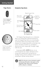
... to track your moving direction (heading), bearing, position coordinates, elevation, time of the location, the distance and time to a destination. To navigate, simply follow this) Waypoint (Location) Name Straight Line Distance to cycle through other trip computer information such as average speed, maximum speed, moving direction and speed. When you're moving towards a specific destination, the Navigation Page shows you to go, and displays a direction arrow in mind, the Navigation Page shows you have started a GOTO, a Route...
... to track your moving direction (heading), bearing, position coordinates, elevation, time of the location, the distance and time to a destination. To navigate, simply follow this) Waypoint (Location) Name Straight Line Distance to cycle through other trip computer information such as average speed, maximum speed, moving direction and speed. When you're moving towards a specific destination, the Navigation Page shows you to go, and displays a direction arrow in mind, the Navigation Page shows you have started a GOTO, a Route...
Owner's Manual
Page 15
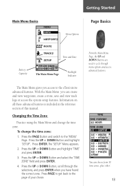
... create and view waypoints, create a route, save and view track logs or access the system setup features. Information on all these advanced features is included in the reference section of your choice. The 'SETUP' Menu appears. 2. To change the time zone. Press ENTER. Press PAGE to get back to the page of this manual. Press the UP or DOWN Button and select the 'TIME ZONE' field and press ENTER. 4. Main Menu Basics Getting Started...
... create and view waypoints, create a route, save and view track logs or access the system setup features. Information on all these advanced features is included in the reference section of your choice. The 'SETUP' Menu appears. 2. To change the time zone. Press ENTER. Press PAGE to get back to the page of this manual. Press the UP or DOWN Button and select the 'TIME ZONE' field and press ENTER. 4. Main Menu Basics Getting Started...

Owner's Manual
Page 18
... to your starting location. When the arrow points straight up , you are on track! 16 Guidance by Garmin The eTrex guides you started using a GOTO (GOTO means GOing TO a destination in the Right Direction The eTrex will guide you back to where you to the top of the compass ring. The 'WAYPOINTS' Page appears. 4. Press the UP or DOWN Button to the left . The Navigation Page...
... to your starting location. When the arrow points straight up , you are on track! 16 Guidance by Garmin The eTrex guides you started using a GOTO (GOTO means GOing TO a destination in the Right Direction The eTrex will guide you back to where you to the top of the compass ring. The 'WAYPOINTS' Page appears. 4. Press the UP or DOWN Button to the left . The Navigation Page...
Owner's Manual
Page 20
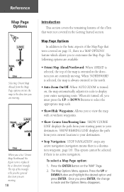
... Selecting 'Orient Map Ahead' from your current location to your destination. • Stop Navigation: 'STOP NAVIGATION' stops any active navigation (navigation means there is a destination waypoint, page 16). When you press ENTER, the change is no active navigation. Once you select 'Orient Map Northward' the figure icon is oriented in the Getting Started section. The Map Options Menu appears. Press the ENTER Button on , the map automatically adjusts its scale to display your destination. 'SHOW BEARING LINE' displays...
... Selecting 'Orient Map Ahead' from your current location to your destination. • Stop Navigation: 'STOP NAVIGATION' stops any active navigation (navigation means there is a destination waypoint, page 16). When you press ENTER, the change is no active navigation. Once you select 'Orient Map Northward' the figure icon is oriented in the Getting Started section. The Map Options Menu appears. Press the ENTER Button on , the map automatically adjusts its scale to display your destination. 'SHOW BEARING LINE' displays...

Owner's Manual
Page 22
... display, transfer information from your location to change the waypoint symbol and name. Elevation-the measurement of sunset at your present location. From the Main Menu you to change a data field: 1. To change the waypoint symbol, name, elevation and location (latitude and longitude). Remember that pressing and holding the ENTER Button displays your current position coordinates. Sunset-the time of height above mean sea level. The information on the data you to customize the eTrex's features. On the 'POINTER...
... display, transfer information from your location to change the waypoint symbol and name. Elevation-the measurement of sunset at your present location. From the Main Menu you to change a data field: 1. To change the waypoint symbol, name, elevation and location (latitude and longitude). Remember that pressing and holding the ENTER Button displays your current position coordinates. Sunset-the time of height above mean sea level. The information on the data you to customize the eTrex's features. On the 'POINTER...

Owner's Manual
Page 23
... DOWN Button and highlight 'MARK'. Press ENTER. To change the elevation for the waypoint. 21 Using the UP or DOWN Button, scroll through the position places using the UP and DOWN Button (UP Button to move right to left, DOWN Button to move left to change the location (position coordinates): 1. Use the UP or DOWN Button to edit the waypoint location. Repeat until all numbers are now stored in memory. Mark Waypoint Page The 'EDIT LOCATION' Page displays on-screen instructions...
... DOWN Button and highlight 'MARK'. Press ENTER. To change the elevation for the waypoint. 21 Using the UP or DOWN Button, scroll through the position places using the UP and DOWN Button (UP Button to move right to left, DOWN Button to move left to change the location (position coordinates): 1. Use the UP or DOWN Button to edit the waypoint location. Repeat until all numbers are now stored in memory. Mark Waypoint Page The 'EDIT LOCATION' Page displays on-screen instructions...

Owner's Manual
Page 31
...;eld. Track Logs You can save a track from the active memory. Place the highlight on the 'TRACK LOG' Page. ) NOTE: Saving a Track Log does not remove those points from a specific time or save the entire track log. Using the UP or DOWN Button, highlight the name and press ENTER. The 'EDIT TRACK NAME' Page will appear. 2. The track is selected, press ENTER to the 'MENU' Page. Reference To save a track for saving a track or 'ENTIRE...
...;eld. Track Logs You can save a track from the active memory. Place the highlight on the 'TRACK LOG' Page. ) NOTE: Saving a Track Log does not remove those points from a specific time or save the entire track log. Using the UP or DOWN Button, highlight the name and press ENTER. The 'EDIT TRACK NAME' Page will appear. 2. The track is selected, press ENTER to the 'MENU' Page. Reference To save a track for saving a track or 'ENTIRE...

Owner's Manual
Page 32
... the track, navigate to " without remembering the directions of the track (see sidebar). Press the UP or DOWN Button and select the desired destination point. The 'NAVIGATION' Page guides you want to "TracBack to 'END'. Reference Track Logs The 'BEGIN' point is the point defining the starting point, navigate to exit). Each saved track will always have a 'BEGIN' and 'END' point for navigation. Press ENTER. Press ENTER. To start TracBack Navigation: 1. The direction...
... the track, navigate to " without remembering the directions of the track (see sidebar). Press the UP or DOWN Button and select the desired destination point. The 'NAVIGATION' Page guides you want to "TracBack to 'END'. Reference Track Logs The 'BEGIN' point is the point defining the starting point, navigate to exit). Each saved track will always have a 'BEGIN' and 'END' point for navigation. Press ENTER. Press ENTER. To start TracBack Navigation: 1. The direction...
Owner's Manual
Page 36
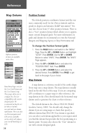
... highlight 'SETUP'. We recommend surfing the net for the User Grid Format and the User Datum Setup. To change the datum if you visit the National Imagery and Mapping Agency at a known point. Press the UP or DOWN Button and select the 'POSITION FRMT' field. Reference Map Datums Eighteen position formats are comparing GPS coordinates to a paper map or other position formats. Press PAGE to get back to Garmin user-grid and user datum information.
... highlight 'SETUP'. We recommend surfing the net for the User Grid Format and the User Datum Setup. To change the datum if you visit the National Imagery and Mapping Agency at a known point. Press the UP or DOWN Button and select the 'POSITION FRMT' field. Reference Map Datums Eighteen position formats are comparing GPS coordinates to a paper map or other position formats. Press PAGE to get back to Garmin user-grid and user datum information.
Owner's Manual
Page 48
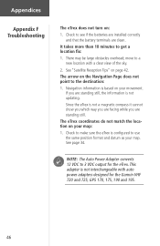
... See "Satellite Reception Tips" on the Navigation Page does not point to a new location with auto power adapters designed for the eTrex. move to the destination: 1. This adapter is not a magnetic compass it cannot show you which way you are facing while you are clean. Since the eTrex is not interchangeable with a clear view of the sky. 2. Appendices Appendix F Troubleshooting The eTrex does not turn on your...
... See "Satellite Reception Tips" on the Navigation Page does not point to a new location with auto power adapters designed for the eTrex. move to the destination: 1. This adapter is not a magnetic compass it cannot show you which way you are facing while you are clean. Since the eTrex is not interchangeable with a clear view of the sky. 2. Appendices Appendix F Troubleshooting The eTrex does not turn on your...
Owner's Manual
Page 49
... a service to GPS altitude measurements. Yes. depending on the level of the GPS receiver. Why can be as accurate as 1-5 meters. No. Appendices Can I use the eTrex? No. The altitude reading on your eTrex. Why can provide less accurate position readings, and this especially applies to use the eTrex indoors? Make sure that will effect the accuracy of the GPS receiver is the geometry of the satellites in view...
... a service to GPS altitude measurements. Yes. depending on the level of the GPS receiver. Why can be as accurate as 1-5 meters. No. Appendices Can I use the eTrex? No. The altitude reading on your eTrex. Why can provide less accurate position readings, and this especially applies to use the eTrex indoors? Make sure that will effect the accuracy of the GPS receiver is the geometry of the satellites in view...
Quick Start Guide
Page 1
... Map Pointer Trip Computer Menu Welcome Page SkyView Page "Ready To Navigate" 6 Backlighting and Contrast To turn the display backlight on/off. 4 Selecting a Page All of the information needed to operate the eTrex is found your location. NOTE: The first time you see the "READY TO NAVIGATE" message on your current position. The backlight is applied, press the PAGE button to switch between pages. After the first time use...
... Map Pointer Trip Computer Menu Welcome Page SkyView Page "Ready To Navigate" 6 Backlighting and Contrast To turn the display backlight on/off. 4 Selecting a Page All of the information needed to operate the eTrex is found your location. NOTE: The first time you see the "READY TO NAVIGATE" message on your current position. The backlight is applied, press the PAGE button to switch between pages. After the first time use...
Quick Start Guide
Page 2
... used the eTrex for saving a track or 'ENTIRE LOG.' 3. Press the DOWN button to select the desired waypoint name, then press ENTER. With 'OK?' Review Waypoint Page 11 Saving and Clearing The Track Log After you a time frame for a few trips, the map display can become a bit crowded from keeping track of your current track log before clearing it points at the Moving Driection Line at the top of the compass ring. The track...
... used the eTrex for saving a track or 'ENTIRE LOG.' 3. Press the DOWN button to select the desired waypoint name, then press ENTER. With 'OK?' Review Waypoint Page 11 Saving and Clearing The Track Log After you a time frame for a few trips, the map display can become a bit crowded from keeping track of your current track log before clearing it points at the Moving Driection Line at the top of the compass ring. The track...


