
XM Satellite Radio Activation Instructions
Page 10
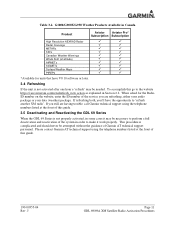
... the past 3 hours. To accomplish this go to confirm the activation of the radio. J MX20 Weather Products Available in United States Product High Resolution NEXRAD Radar Radar Coverage Precipitation Type (at surface) City Forcasts TFRs METARs TAFs County Warnings Winds Aloft (at altitude) Lightning AIRMETs SIGMETs Echo Tops Severe Weather Storm Tracks...
... the past 3 hours. To accomplish this go to confirm the activation of the radio. J MX20 Weather Products Available in United States Product High Resolution NEXRAD Radar Radar Coverage Precipitation Type (at surface) City Forcasts TFRs METARs TAFs County Warnings Winds Aloft (at altitude) Lightning AIRMETs SIGMETs Echo Tops Severe Weather Storm Tracks...

XM Satellite Radio Activation Instructions
Page 16
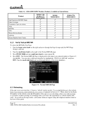
Channel Listings Screen Table 3-1. J G1000/G900X/G950 Weather Products Available in United States Product High Resolution NEXRAD Radar Radar Coverage Precipitation Type (at surface) City Forcasts TFRs METARs TAFs County Warnings Winds Aloft (at altitude) Lightning AIRMETs SIGMETs Echo Tops Freezing Level Severe Weather ...
Channel Listings Screen Table 3-1. J G1000/G900X/G950 Weather Products Available in United States Product High Resolution NEXRAD Radar Radar Coverage Precipitation Type (at surface) City Forcasts TFRs METARs TAFs County Warnings Winds Aloft (at altitude) Lightning AIRMETs SIGMETs Echo Tops Freezing Level Severe Weather ...
XM Satellite Radio Activation Instructions
Page 17
.../G950 Weather Products Available in Canada Product Aviator Aviator Pro* Subscription Subscription High Resolution NEXRAD Radar Radar Coverage METARs TAFs Canadian... Weather Warnings Winds Aloft (at the front of the system in order to the website https://care.siriusxm.com/retailrefresh_view.action as explained in some cases it work properly. If you are having trouble, call Garmin...
.../G950 Weather Products Available in Canada Product Aviator Aviator Pro* Subscription Subscription High Resolution NEXRAD Radar Radar Coverage METARs TAFs Canadian... Weather Warnings Winds Aloft (at the front of the system in order to the website https://care.siriusxm.com/retailrefresh_view.action as explained in some cases it work properly. If you are having trouble, call Garmin...
XM Satellite Radio Activation Instructions
Page 28
...enter the ID number of four letter identifiers. GNS 430W/530W Weather Products Available in United States Product High Resolution NEXRAD Radar Radar Coverage Precipitation Type (at surface) TFRs METARs TAFs Winds Aloft (at the front of this go to the website https...://care.siriusxm.com/retailrefresh_view.action as explained in Section 2.2. Figure 5-3. When asked for the airport you are having trouble, call Garmin technical support using the telephone numbers listed at altitude) Lightning Severe Weather Storm Tracks Aviator Lite (Aviator LT) Subscription Aviator Subscription...
...enter the ID number of four letter identifiers. GNS 430W/530W Weather Products Available in United States Product High Resolution NEXRAD Radar Radar Coverage Precipitation Type (at surface) TFRs METARs TAFs Winds Aloft (at the front of this go to the website https...://care.siriusxm.com/retailrefresh_view.action as explained in Section 2.2. Figure 5-3. When asked for the airport you are having trouble, call Garmin technical support using the telephone numbers listed at altitude) Lightning Severe Weather Storm Tracks Aviator Lite (Aviator LT) Subscription Aviator Subscription...

XM Satellite Radio Activation Instructions
Page 32
Data Radio ID and Audio Radio ID Locations Figure 6-2. J GMX 200 Weather Products Available in United States Product High Resolution NEXRAD Radar Radar Coverage Precipitation Type (at surface) City Forecasts TFRs METARs TAFs County Warnings Winds Aloft (at altitude) Lightning AIRMETs SIGMETs Echo Tops Freezing Level Severe Weather ...
Data Radio ID and Audio Radio ID Locations Figure 6-2. J GMX 200 Weather Products Available in United States Product High Resolution NEXRAD Radar Radar Coverage Precipitation Type (at surface) City Forecasts TFRs METARs TAFs County Warnings Winds Aloft (at altitude) Lightning AIRMETs SIGMETs Echo Tops Freezing Level Severe Weather ...

XM Satellite Radio Activation Instructions
Page 36
... GDL 69/69A XM Satellite Radio Activation Procedures 190-00355-04 Rev. Figure 7-2. G500/G600 Weather Products Available in United States Product High Resolution NEXRAD Radar Radar Coverage Precipitation Type (at surface) City Forecasts TFRs METARs TAFs County Warnings Winds Aloft (at altitude) Lightning AIRMETs SIGMETs Echo Tops Freezing Level Severe Weather...
... GDL 69/69A XM Satellite Radio Activation Procedures 190-00355-04 Rev. Figure 7-2. G500/G600 Weather Products Available in United States Product High Resolution NEXRAD Radar Radar Coverage Precipitation Type (at surface) City Forecasts TFRs METARs TAFs County Warnings Winds Aloft (at altitude) Lightning AIRMETs SIGMETs Echo Tops Freezing Level Severe Weather...

XM Satellite Radio Activation Instructions
Page 43
... perform a full deactivation and reactivation of this guide. 190-00355-04 Rev. GTN 625/635/650 and GTN 725/750 Weather Products Available in United States Product High Resolution NEXRAD Radar Radar Coverage Precipitation Type (at surface) City Forecasts TFRs METARs TAFs County Warnings Winds ...Aloft (at the front of the system in some cases it may be attempted without the guidance of Garmin...
... perform a full deactivation and reactivation of this guide. 190-00355-04 Rev. GTN 625/635/650 and GTN 725/750 Weather Products Available in United States Product High Resolution NEXRAD Radar Radar Coverage Precipitation Type (at surface) City Forecasts TFRs METARs TAFs County Warnings Winds ...Aloft (at the front of the system in some cases it may be attempted without the guidance of Garmin...
Cockpit Reference Guide
Page 3
... traffic. WARNING: For safety reasons, GTN 725/750 operational procedures must maneuver the aircraft based only upon ATC guidance or positive visual acquisition of the GTN 725/750 Pilot's Guide as well as severe or giving an intense radar echo." Therefore, as with all GPS equipment.... Weather information provided by the GTN 725/750 can be learned on the GTN 725/750 is provided as a precision electronic NAVigation...
... traffic. WARNING: For safety reasons, GTN 725/750 operational procedures must maneuver the aircraft based only upon ATC guidance or positive visual acquisition of the GTN 725/750 Pilot's Guide as well as severe or giving an intense radar echo." Therefore, as with all GPS equipment.... Weather information provided by the GTN 725/750 can be learned on the GTN 725/750 is provided as a precision electronic NAVigation...
Pilot's Guide
Page 2
...storage medium to later software versions. NavData® is a registered trademark of Garmin Ltd. StormScope® and SkyWatch® are registered trademarks of XM Satellite Radio, Inc.; United States radar data provided by Environment Canada; Some differences in operation may not be viewed for... by NOAA; March 2011 Printed in the U.S.A. Tel: 913/397.8200 Fax: 913/397.8282 Garmin AT, Inc., 2345 Turner Road SE, Salem, OR 97302, U.S.A. European radar data collected and provided by Meteo France. Iridium® is a trademark of Jeppesen, Inc.; This...
...storage medium to later software versions. NavData® is a registered trademark of Garmin Ltd. StormScope® and SkyWatch® are registered trademarks of XM Satellite Radio, Inc.; United States radar data provided by Environment Canada; Some differences in operation may not be viewed for... by NOAA; March 2011 Printed in the U.S.A. Tel: 913/397.8200 Fax: 913/397.8282 Garmin AT, Inc., 2345 Turner Road SE, Salem, OR 97302, U.S.A. European radar data collected and provided by Meteo France. Iridium® is a trademark of Jeppesen, Inc.; This...
Pilot's Guide
Page 5
...aircraft based only upon ATC guidance or positive visual acquisition of the Garmin GTN 725/750 System utilize GPS as with all GPS equipment. Therefore, as a precision electronic NAVigation AID (NAVAID). B Garmin GTN 725/750 Pilot's Guide iii Index Weather information provided by the GDL 69...GPS system is provided as severe or giving an intense radar echo." WARNING: Datalink eeather should not be used for its accuracy and maintenance. During flight operations, carefully compare indications from the GTN 725/750 to changes which could affect the accuracy and performance ...
...aircraft based only upon ATC guidance or positive visual acquisition of the Garmin GTN 725/750 System utilize GPS as with all GPS equipment. Therefore, as a precision electronic NAVigation AID (NAVAID). B Garmin GTN 725/750 Pilot's Guide iii Index Weather information provided by the GDL 69...GPS system is provided as severe or giving an intense radar echo." WARNING: Datalink eeather should not be used for its accuracy and maintenance. During flight operations, carefully compare indications from the GTN 725/750 to changes which could affect the accuracy and performance ...

Pilot's Guide
Page 182
... Terrain 2. While viewing the Map Menu, touch the StormScope Map Overlay key to the display. See the Weather section for selecting the StormScope radar weather data display mode (Cell, Strike, or Off). Com/Nav FPL Direct-To Proc NOTE: Refer to the WX-500 Pilot's Guide...Nearest Music Utilities System Messages Symbols Icon Shows StormScope Overlay Is Active Appendix Index 9-8 Figure 9-9 Map Menu StormScope Map Overlay On Selection Garmin GTN 725/750 Pilot's Guide 190-01007-03 Rev. StormScope data will be overlayed on the Map page when Cell or Strike is a passive weather ...
... Terrain 2. While viewing the Map Menu, touch the StormScope Map Overlay key to the display. See the Weather section for selecting the StormScope radar weather data display mode (Cell, Strike, or Off). Com/Nav FPL Direct-To Proc NOTE: Refer to the WX-500 Pilot's Guide...Nearest Music Utilities System Messages Symbols Icon Shows StormScope Overlay Is Active Appendix Index 9-8 Figure 9-9 Map Menu StormScope Map Overlay On Selection Garmin GTN 725/750 Pilot's Guide 190-01007-03 Rev. StormScope data will be overlayed on the Map page when Cell or Strike is a passive weather ...

Pilot's Guide
Page 211
... are shown without altitude reporting capability are invisible to both be configured at the same time. The GTN 7XX displays up to eight traffic targets within the service volume of a TIS-capable terminal radar site. B Garmin GTN 725/750 Pilot's Guide 10-1 Index It is intended to help in detection and avoidance of the pilot...
... are shown without altitude reporting capability are invisible to both be configured at the same time. The GTN 7XX displays up to eight traffic targets within the service volume of a TIS-capable terminal radar site. B Garmin GTN 725/750 Pilot's Guide 10-1 Index It is intended to help in detection and avoidance of the pilot...

Pilot's Guide
Page 212
...five Map NM. Altitude trend is displayed above the traffic symbol with transponders, nor can be nearby, but obscured from the ground surveillance radar by a half TA symbol at the edge of the screen at the relative bearing of aircraft that an intruding aircraft is at greater than... Music other aircraft is displayed in the center of the Weather Traffic Page or in hundreds of the target symbol. Appendix Index 10-2 Garmin GTN 725/750 Pilot's Guide 190-01007-03 Rev. TIS Symbol Description Non-Threat Traffic FPL Traffic Advisory (TA) Direct-To Traffic Advisory Off Scale Proc...
...five Map NM. Altitude trend is displayed above the traffic symbol with transponders, nor can be nearby, but obscured from the ground surveillance radar by a half TA symbol at the edge of the screen at the relative bearing of aircraft that an intruding aircraft is at greater than... Music other aircraft is displayed in the center of the Weather Traffic Page or in hundreds of the target symbol. Appendix Index 10-2 Garmin GTN 725/750 Pilot's Guide 190-01007-03 Rev. TIS Symbol Description Non-Threat Traffic FPL Traffic Advisory (TA) Direct-To Traffic Advisory Off Scale Proc...

Pilot's Guide
Page 215
... to assist in visual FPL acquisition of other maneuvering. No recommended avoidance maneuvers are inherent in secondary radar surveillance. Nearest Music Utilities Garmin is the responsibility of the FAA. TIS Wpt Info will be used as a direct result of...is intended only to the Aeronautical Information Manual for Mode S geographical coverage. B Garmin GTN 725/750 Pilot's Guide 10-5 Index Operation of the ground stations is not responsible for a Terminal Mode S Radar Site Map covering the U.S. TIS operation may be temporarily interrupted. 10.1.5 TIS ...
... to assist in visual FPL acquisition of other maneuvering. No recommended avoidance maneuvers are inherent in secondary radar surveillance. Nearest Music Utilities Garmin is the responsibility of the FAA. TIS Wpt Info will be used as a direct result of...is intended only to the Aeronautical Information Manual for Mode S geographical coverage. B Garmin GTN 725/750 Pilot's Guide 10-5 Index Operation of the ground stations is not responsible for a Terminal Mode S Radar Site Map covering the U.S. TIS operation may be temporarily interrupted. 10.1.5 TIS ...

Pilot's Guide
Page 216
...radar scans once the course has stabilized. FPL This algorithm uses track history data to extrapolate intruders to present the intruders in a "real time" position, the TIS ground station uses a "predictive algorithm" in its tracking software. Music Utilities System Messages Symbols Appendix Index 10-6 Garmin GTN 725/750... and Charts may be used to induce errors in the cockpit. Therefore, the surveillance information is collected one radar scan prior to the scan during which the uplink occurs. Occasionally, aircraft maneuvering will cause this algorithm to assist...
...radar scans once the course has stabilized. FPL This algorithm uses track history data to extrapolate intruders to present the intruders in a "real time" position, the TIS ground station uses a "predictive algorithm" in its tracking software. Music Utilities System Messages Symbols Appendix Index 10-6 Garmin GTN 725/750... and Charts may be used to induce errors in the cockpit. Therefore, the surveillance information is collected one radar scan prior to the scan during which the uplink occurs. Occasionally, aircraft maneuvering will cause this algorithm to assist...

Pilot's Guide
Page 217
... Info Traffic may not be displayed in the area. B Garmin GTN 725/750 Pilot's Guide 10-7 Index As long as a single TA remains on the display, Direct-To no TAs are detected in the radar coverage area due to the next, the following : Map • Radar site TIS Mode S sensor is not operational or is...
... Info Traffic may not be displayed in the area. B Garmin GTN 725/750 Pilot's Guide 10-7 Index As long as a single TA remains on the display, Direct-To no TAs are detected in the radar coverage area due to the next, the following : Map • Radar site TIS Mode S sensor is not operational or is...

Pilot's Guide
Page 236
Touch the Flight Plan key to toggle the display of the aircraft: the 360° default display and the radar-like ARC (120°) display. Appendix Index 11-10 Garmin GTN 725/750 Pilot's Guide 190-01007-03 Rev. Com/Nav Select Terrain View Select Displayed Layer FPL Direct-To Proc Charts Wpt Info Map...
Touch the Flight Plan key to toggle the display of the aircraft: the 360° default display and the radar-like ARC (120°) display. Appendix Index 11-10 Garmin GTN 725/750 Pilot's Guide 190-01007-03 Rev. Com/Nav Select Terrain View Select Displayed Layer FPL Direct-To Proc Charts Wpt Info Map...

Pilot's Guide
Page 254
Foreword Getting Started Audio & Xpdr Ctrl Com/Nav FPL Direct-To Weather Product Radar Coverage Temporary Flight Restriction (TFR) Terminal Aerodrome Forecast (TAF) Expiration Time (Minutes) 30 60 60 Refresh Rate (Minutes) 5 12 12 Table 12-1 Weather Products and ... Music Utilities System Messages Sunny Part Sun Cloudy Rainy T-Storm Snow Windy Foggy Haze High/Low Temp Table 12-2 Weather Symbols Symbols Appendix Index 12-8 Garmin GTN 725/750 Pilot's Guide 190-01007-03 Rev. B
Foreword Getting Started Audio & Xpdr Ctrl Com/Nav FPL Direct-To Weather Product Radar Coverage Temporary Flight Restriction (TFR) Terminal Aerodrome Forecast (TAF) Expiration Time (Minutes) 30 60 60 Refresh Rate (Minutes) 5 12 12 Table 12-1 Weather Products and ... Music Utilities System Messages Sunny Part Sun Cloudy Rainy T-Storm Snow Windy Foggy Haze High/Low Temp Table 12-2 Weather Symbols Symbols Appendix Index 12-8 Garmin GTN 725/750 Pilot's Guide 190-01007-03 Rev. B

Pilot's Guide
Page 255
... the NEXRAD Terrain key to the inherent delays and the relative Direct-To age of the maximum reflectivity from the individual radar sweeps. B Garmin GTN 725/750 Pilot's Guide 12-9 Index resolution Doppler radar systems that are operated by Environment Canada. Traffic 1. Never use it in the United States is composed of the data, it...
... the NEXRAD Terrain key to the inherent delays and the relative Direct-To age of the maximum reflectivity from the individual radar sweeps. B Garmin GTN 725/750 Pilot's Guide 12-9 Index resolution Doppler radar systems that are operated by Environment Canada. Traffic 1. Never use it in the United States is composed of the data, it...

Pilot's Guide
Page 256
... are measured in the atmosphere. Repeated touches to reflectivity (Z). NEXRAD measures the radar reflectivity ratio, or the energy reflected back to the radar receiver. System Messages Symbols Appendix Index 12-10 Garmin GTN 725/750 Pilot's Guide 190-01007-03 Rev. FPL Direct-To Proc Charts Wpt Info... 12.1.5.1 Figure 12-8 NEXRAD Weather Legend Reflectivity Map Reflectivity is the amount of the weather hazard level. The role of radar is not necessarily an indication...
... are measured in the atmosphere. Repeated touches to reflectivity (Z). NEXRAD measures the radar reflectivity ratio, or the energy reflected back to the radar receiver. System Messages Symbols Appendix Index 12-10 Garmin GTN 725/750 Pilot's Guide 190-01007-03 Rev. FPL Direct-To Proc Charts Wpt Info... 12.1.5.1 Figure 12-8 NEXRAD Weather Legend Reflectivity Map Reflectivity is the amount of the weather hazard level. The role of radar is not necessarily an indication...
