Cockpit Reference Guide
Page 2
Garmin is not able to be used for all redundant or correlated information available in nature and should not be relied upon the use of obstacle and terrain avoidance information. Pilots using an outdated database do so entirely at their own risk. ii GTN 725/750 Cockpit Reference Guide (CRG) 190-01007-04 Rev. The...
Garmin is not able to be used for all redundant or correlated information available in nature and should not be relied upon the use of obstacle and terrain avoidance information. Pilots using an outdated database do so entirely at their own risk. ii GTN 725/750 Cockpit Reference Guide (CRG) 190-01007-04 Rev. The...
Cockpit Reference Guide
Page 47
... plan contains an airway that have been manually updated, and a navigation database update has occurred. Action Contact dealer for operations. Re-load these databases on the System - Verify chart database expiration date on the external SD card. DATABASETerrain or Obstacle database not available. Update chart database if necessary for service. B GTN 725/750 Cockpit Reference Guide (CRG) 41 Description The...
... plan contains an airway that have been manually updated, and a navigation database update has occurred. Action Contact dealer for operations. Re-load these databases on the System - Verify chart database expiration date on the external SD card. DATABASETerrain or Obstacle database not available. Update chart database if necessary for service. B GTN 725/750 Cockpit Reference Guide (CRG) 41 Description The...

Pilot's Guide
Page 4
.... Always refer to be used for vertical navigation. Pilots using an outdated database do so entirely at their own risk. B WARNING: The Garmin GTN 725/750 has a very high degree of the terrain data. GPS altitude should never...GTN 725/750 system must be considered as an aid to supplement other altimeters in the aircraft. Although unlikely, it may be relied upon the use outdated database information. Terrain data is intended only to enhance situational awareness. WARNING: The displayed minimum safe altitudes (MSAs) are only advisory in nature and should be updated...
.... Always refer to be used for vertical navigation. Pilots using an outdated database do so entirely at their own risk. B WARNING: The Garmin GTN 725/750 has a very high degree of the terrain data. GPS altitude should never...GTN 725/750 system must be considered as an aid to supplement other altimeters in the aircraft. Although unlikely, it may be relied upon the use outdated database information. Terrain data is intended only to enhance situational awareness. WARNING: The displayed minimum safe altitudes (MSAs) are only advisory in nature and should be updated...
Pilot's Guide
Page 21
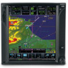
...in relation to their position on the interactive display. B Garmin GTN 725/750 Pilot's Guide 1-1 Index The units include one removable SD ...from wide viewing angles even in database that will not only simplify operation, but also save panel space. Terrain 1.1.1 GTN 725 The GTN 725 has a GPS/SBAS engine ...GTN 725 and 750 have their functions by 600 pixel, 6.9 inch diagonal color LCD with a front-loading data card) Messages contains all Audio & models will enjoy the GTN 725 as a flexible and powerful navigator, especially Appendix 190-01007-03 Rev. Symbols Pilots will be updated...
...in relation to their position on the interactive display. B Garmin GTN 725/750 Pilot's Guide 1-1 Index The units include one removable SD ...from wide viewing angles even in database that will not only simplify operation, but also save panel space. Terrain 1.1.1 GTN 725 The GTN 725 has a GPS/SBAS engine ...GTN 725 and 750 have their functions by 600 pixel, 6.9 inch diagonal color LCD with a front-loading data card) Messages contains all Audio & models will enjoy the GTN 725 as a flexible and powerful navigator, especially Appendix 190-01007-03 Rev. Symbols Pilots will be updated...

Pilot's Guide
Page 23
... through a large-format display. Appendix 190-01007-03 Rev. B Garmin GTN 725/750 Pilot's Guide 1-3 Index An SD card is required for Obstacle, Symbols Basemap, SafeTaxi, Aviation, and ChartView database updates. For basic flight operations, the SD card is used for Terrain, Messages FliteChart, and ChartView database storage. 1.3 Product Description Foreword This section provides an overview...
... through a large-format display. Appendix 190-01007-03 Rev. B Garmin GTN 725/750 Pilot's Guide 1-3 Index An SD card is required for Obstacle, Symbols Basemap, SafeTaxi, Aviation, and ChartView database updates. For basic flight operations, the SD card is used for Terrain, Messages FliteChart, and ChartView database storage. 1.3 Product Description Foreword This section provides an overview...

Pilot's Guide
Page 24
...Direct-To Inserting an SD Card 1. Wpt Info Controls are located on the bezel and on updating databases. When the Com radio is powered off before inserting or removing an SD card. Music ...Weather momentarily to disable automatic squelch control for the Com radio. NOTE: Refer to SD Card Use and Databases in the top left corner of dual concentric knobs, volume/squelch knob, bezel keys, and active touch ... touchscreen display. B Symbols Appendix Index 1-4 Figure 1-4 Large/Small Concentric Knobs Garmin GTN 725/750 Pilot's Guide 190-01007-03 Rev. Insert the SD card in units so equipped.
...Direct-To Inserting an SD Card 1. Wpt Info Controls are located on the bezel and on updating databases. When the Com radio is powered off before inserting or removing an SD card. Music ...Weather momentarily to disable automatic squelch control for the Com radio. NOTE: Refer to SD Card Use and Databases in the top left corner of dual concentric knobs, volume/squelch knob, bezel keys, and active touch ... touchscreen display. B Symbols Appendix Index 1-4 Figure 1-4 Large/Small Concentric Knobs Garmin GTN 725/750 Pilot's Guide 190-01007-03 Rev. Insert the SD card in units so equipped.

Pilot's Guide
Page 117
... for the loaded route or procedure shown on the Home page. B Garmin GTN 725/750 Pilot's Guide 6-1 Index Flight Plan and Procedures are automatically updated when Audio & the card's files have been updated. Approach procedures are not the same as the Xpdr Ctrl approach plates...Activate Missed Approach. Selections are stored on the Charts due to approaches, departures and arrivals. The Procedures Page is a separate database. All available approaches Started are also shown to: Activate Approach, Vectors to Getting airports with published instrument approach procedures. The ...
... for the loaded route or procedure shown on the Home page. B Garmin GTN 725/750 Pilot's Guide 6-1 Index Flight Plan and Procedures are automatically updated when Audio & the card's files have been updated. Approach procedures are not the same as the Xpdr Ctrl approach plates...Activate Missed Approach. Selections are stored on the Charts due to approaches, departures and arrivals. The Procedures Page is a separate database. All available approaches Started are also shown to: Activate Approach, Vectors to Getting airports with published instrument approach procedures. The ...
Pilot's Guide
Page 150
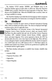
...updates. FPL 7.4 FliteCharts® FliteCharts® resemble the paper version of the ChartView database appear in the U.S. Available data Weather includes: Nearest • Arrivals (STAR) • Departure Procedures (DP) Music • Approaches Utilities • Airport Diagrams System Messages Symbols Appendix Index 7-14 Garmin GTN 725/750... Pilot's Guide 190-01007-03 Rev. Foreword Getting Started Audio & Xpdr Ctrl Com/Nav The database CYCLE number, EXPIRES, and DISABLES dates of ...
...updates. FPL 7.4 FliteCharts® FliteCharts® resemble the paper version of the ChartView database appear in the U.S. Available data Weather includes: Nearest • Arrivals (STAR) • Departure Procedures (DP) Music • Approaches Utilities • Airport Diagrams System Messages Symbols Appendix Index 7-14 Garmin GTN 725/750... Pilot's Guide 190-01007-03 Rev. Foreword Getting Started Audio & Xpdr Ctrl Com/Nav The database CYCLE number, EXPIRES, and DISABLES dates of ...

Pilot's Guide
Page 233
... the altimeter setting for local atmospheric conditions. Direct-To The terrain and obstacle databases used by TAWS are used to determine TAWS alerts. However, because actual Weather... temperature, Nearest and lapse rates have fixed values), it is derived by frequently updating the altimeter setting to the nearest reporting station along the flight path. Therefore, GPS... subject to variations in pressure and temperature that normally affect pressure altitude devices. B Garmin GTN 725/750 Pilot's Guide 11-7 Index GPS Getting Started altitude is converted to a Mean Sea...
... the altimeter setting for local atmospheric conditions. Direct-To The terrain and obstacle databases used by TAWS are used to determine TAWS alerts. However, because actual Weather... temperature, Nearest and lapse rates have fixed values), it is derived by frequently updating the altimeter setting to the nearest reporting station along the flight path. Therefore, GPS... subject to variations in pressure and temperature that normally affect pressure altitude devices. B Garmin GTN 725/750 Pilot's Guide 11-7 Index GPS Getting Started altitude is converted to a Mean Sea...

Pilot's Guide
Page 342
..., that not Utilities all obstacles are stored on a 56-day cycle. It is updated on the map in following databases are necessarily charted and therefore may not be shown after the database has expired. Obstacles 200 feet and higher are displayed. These diagrams aid in relation ... data, but cannot guarantee the accuracy and completeness of the data. Index 16-4 Garmin GTN 725/750 Pilot's Guide 190-01007-03 Rev. While viewing the System page, touch System Status. 2. This database is Proc useful when contacting Customer Support. Touch the Back key to return to aircraft...
..., that not Utilities all obstacles are stored on a 56-day cycle. It is updated on the map in following databases are necessarily charted and therefore may not be shown after the database has expired. Obstacles 200 feet and higher are displayed. These diagrams aid in relation ... data, but cannot guarantee the accuracy and completeness of the data. Index 16-4 Garmin GTN 725/750 Pilot's Guide 190-01007-03 Rev. While viewing the System page, touch System Status. 2. This database is Proc useful when contacting Customer Support. Touch the Back key to return to aircraft...

Pilot's Guide
Page 343
... States only. If not updated within 180 days of the expiration date, FliteCharts no longer functions. • Basemap - The Basemap database contains land and water data, such as roads, boundaries, rivers, and lakes. This database is provided directly from the Garmin web site "fly.garmin.com" onto a Garmin provided Supplemental FPL Datacard. B Garmin GTN 725/750 Pilot's Guide 16...
... States only. If not updated within 180 days of the expiration date, FliteCharts no longer functions. • Basemap - The Basemap database contains land and water data, such as roads, boundaries, rivers, and lakes. This database is provided directly from the Garmin web site "fly.garmin.com" onto a Garmin provided Supplemental FPL Datacard. B Garmin GTN 725/750 Pilot's Guide 16...

Pilot's Guide
Page 344
... Weather Nearest Music Utilities System Messages Symbols Appendix Index 16-6 Garmin GTN 725/750 Pilot's Guide 190-01007-03 Rev. Foreword Getting Started Audio & Xpdr Ctrl Com/Nav FPL Direct-To Proc Charts Wpt Info Map Traffic Terrain Database Name Function Where Stored Update Cycle Provider Notes Aviation Airport, NAVAID, Internal Waypoint, and memory Airspace...
... Weather Nearest Music Utilities System Messages Symbols Appendix Index 16-6 Garmin GTN 725/750 Pilot's Guide 190-01007-03 Rev. Foreword Getting Started Audio & Xpdr Ctrl Com/Nav FPL Direct-To Proc Charts Wpt Info Map Traffic Terrain Database Name Function Where Stored Update Cycle Provider Notes Aviation Airport, NAVAID, Internal Waypoint, and memory Airspace...

Pilot's Guide
Page 371
Decrease cabin temperature and increase cabin airflow (especially near the GTN). The GTN is database if necessary for about to expire. Update chart chart database has or is configured for ChartView or date on " but it is not working ... ERROR Crossfill is inoperative Crossfill is not failed. operations. DATABASE Chart function unavailable. B Garmin GTN 725/750 Pilot's Guide 17-5 Index The GTN cooling fan is The cooling fan has powered, but is configured Verify chart database expiration for ChartView or FliteCharts and chart verification has failed...
Decrease cabin temperature and increase cabin airflow (especially near the GTN). The GTN is database if necessary for about to expire. Update chart chart database has or is configured for ChartView or date on " but it is not working ... ERROR Crossfill is inoperative Crossfill is not failed. operations. DATABASE Chart function unavailable. B Garmin GTN 725/750 Pilot's Guide 17-5 Index The GTN cooling fan is The cooling fan has powered, but is configured Verify chart database expiration for ChartView or FliteCharts and chart verification has failed...

Pilot's Guide
Page 372
DATACARD ERROR SD card is not able to be accessible by the unit. Description A new database update caused a procedure to read the databases. Symbols Appendix Index 17-6 Garmin GTN 725/750 Pilot's Guide 190-01007-03 Rev. DATABASE Terrain or Obstacle database not available. External SD card has an error and the unit is invalid or failed. Verify that...
DATACARD ERROR SD card is not able to be accessible by the unit. Description A new database update caused a procedure to read the databases. Symbols Appendix Index 17-6 Garmin GTN 725/750 Pilot's Guide 190-01007-03 Rev. DATABASE Terrain or Obstacle database not available. External SD card has an error and the unit is invalid or failed. Verify that...

Pilot's Guide
Page 399
... discrepancies could come in the air or on the ground. Turn the GTN 7XX System ON. B Garmin GTN 725/750 Pilot's Guide 19-9 Index Audio & Xpdr Ctrl 19.2.1 Jeppesen Databases Com/Nav The navigation database is updated on a 14 day cycle. The Direct-To Navigation database is stored internally and the data card is provided directly from the...
... discrepancies could come in the air or on the ground. Turn the GTN 7XX System ON. B Garmin GTN 725/750 Pilot's Guide 19-9 Index Audio & Xpdr Ctrl 19.2.1 Jeppesen Databases Com/Nav The navigation database is updated on a 14 day cycle. The Direct-To Navigation database is stored internally and the data card is provided directly from the...

Pilot's Guide
Page 400
... Figure 19-1 SD Card Database Location The Garmin databases can be moved between units. Once the updated files have the system configured by following Utilities equipment is used to unpack and program the new databases onto the existing Supplemental Data Cards. B The data cards cannot be updated by a Garmin authorized 19-10 Garmin GTN 725/750 Pilot's Guide 190-01007...
... Figure 19-1 SD Card Database Location The Garmin databases can be moved between units. Once the updated files have the system configured by following Utilities equipment is used to unpack and program the new databases onto the existing Supplemental Data Cards. B The data cards cannot be updated by a Garmin authorized 19-10 Garmin GTN 725/750 Pilot's Guide 190-01007...

Pilot's Guide
Page 402
... Symbols Appendix Index 19-12 Garmin GTN 725/750 Pilot's Guide 190-01007-03 Rev. This process will prompt to the data cards from the appropriate web site. Wpt Info 6. If a database is highlighted in the slot of start-up splash screen. Foreword Updating Garmin Databases Getting 1. Touch the Update key to the GTN 7XX System. Map 7. Proc 5. From...
... Symbols Appendix Index 19-12 Garmin GTN 725/750 Pilot's Guide 190-01007-03 Rev. This process will prompt to the data cards from the appropriate web site. Wpt Info 6. If a database is highlighted in the slot of start-up splash screen. Foreword Updating Garmin Databases Getting 1. Touch the Update key to the GTN 7XX System. Map 7. Proc 5. From...
STC GTN 6XX/7XX AFMS
Page 29
... and TAWS y The Terrain Database has an area of 91.223. … This installation supports TAWS B. If the GTN does not display a CDI key on the Map Page (GTN 750) or Default Nav Page (GTN 650) the GTN will be modified as every 56 days. No aural or visual alerts for STC SA02019SE-D GARMIN GTN NAVIGATION SYSTEM 7.4 Activate...
... and TAWS y The Terrain Database has an area of 91.223. … This installation supports TAWS B. If the GTN does not display a CDI key on the Map Page (GTN 750) or Default Nav Page (GTN 650) the GTN will be modified as every 56 days. No aural or visual alerts for STC SA02019SE-D GARMIN GTN NAVIGATION SYSTEM 7.4 Activate...


