

Owner's Manual
Page 5
... GPSMAP 492/498 External GPS Antenna..... 87 Mounting the GPSMAP 392/398/492/498 88 Installing the Transducer 90 Connecting the Power/Data Cable 92 Interfacing 93 Installing and Removing Data Cards 94 Satellite Information 95 INTRODUCTION > TABLE OF CONTENTS What is WAAS/EGNOS 96 What is a Maritime Mobile Service Identity (MMSI 97 How ARE MMSI assignments obtained 97 Navigation...
... GPSMAP 492/498 External GPS Antenna..... 87 Mounting the GPSMAP 392/398/492/498 88 Installing the Transducer 90 Connecting the Power/Data Cable 92 Interfacing 93 Installing and Removing Data Cards 94 Satellite Information 95 INTRODUCTION > TABLE OF CONTENTS What is WAAS/EGNOS 96 What is a Maritime Mobile Service Identity (MMSI 97 How ARE MMSI assignments obtained 97 Navigation...
Owner's Manual
Page 29
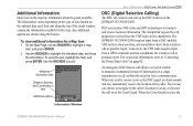
...on page 92. To scroll the text, highlight the field, and press ENTER. DSC uses marine VHF radio and GPS technologies to transmit position coordinates for a Map item: 1. When any nearby rescuer receives the DSC signal, an alarm sounds ...navigate to the caller's location to assist, or forward the call or position report. When the Coast Guard receives the Information Window GPSMAP 392/398/492/498 Owner's Manual 21 Additional Information Each item on the chartplotter. Use the ROCKER to the Coast Guard. For connection information, refer to "Connecting the Power/Data Cable...
...on page 92. To scroll the text, highlight the field, and press ENTER. DSC uses marine VHF radio and GPS technologies to transmit position coordinates for a Map item: 1. When any nearby rescuer receives the DSC signal, an alarm sounds ...navigate to the caller's location to assist, or forward the call or position report. When the Coast Guard receives the Information Window GPSMAP 392/398/492/498 Owner's Manual 21 Additional Information Each item on the chartplotter. Use the ROCKER to the Coast Guard. For connection information, refer to "Connecting the Power/Data Cable...

Owner's Manual
Page 96
... sealant to the antenna connector on the back of the unit. After the GPSMAP 492/498 unit is 5°F to 158°F (-15°C to allow connection of the antenna (external antenna only), power/data cables. • The mounting surface should be used for mounting in storage or operating...boat's superstructure, a radar arch, or mast. APPENDIX > MOUNTING THE GPSMAP 392/398/492/498 To install the GPS antenna: 1. When choosing a location for the GPSMAP 392/398/492/498 is installed, connect the cable to secure the cable along the route and through any bulkhead or deck. 3. Screw the ...
... sealant to the antenna connector on the back of the unit. After the GPSMAP 492/498 unit is 5°F to 158°F (-15°C to allow connection of the antenna (external antenna only), power/data cables. • The mounting surface should be used for mounting in storage or operating...boat's superstructure, a radar arch, or mast. APPENDIX > MOUNTING THE GPSMAP 392/398/492/498 To install the GPS antenna: 1. When choosing a location for the GPSMAP 392/398/492/498 is installed, connect the cable to secure the cable along the route and through any bulkhead or deck. 3. Screw the ...
Owner's Manual
Page 100
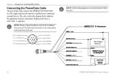
Accessory On DC Power Source CANet L CANet H 92 GPSMAP 392/398/492/498 Owner's Manual APPENDIX > CONNECTING THE POWER/DATA CABLE Connecting the Power/Data Cable The power/data cable connects the GPSMAP 392/398/492/498 to be connected for connecting external devices. The other wires do not have to a DC supply and provides interface capabilities for normal operation of the ...
Accessory On DC Power Source CANet L CANet H 92 GPSMAP 392/398/492/498 Owner's Manual APPENDIX > CONNECTING THE POWER/DATA CABLE Connecting the Power/Data Cable The power/data cable connects the GPSMAP 392/398/492/498 to be connected for connecting external devices. The other wires do not have to a DC supply and provides interface capabilities for normal operation of the ...
Owner's Manual
Page 110
...000 waypoints available. This only appears when the track recording setting is not a transducer attached, bad cable/transducer, or the transducer cable was disconnected. Transducer Disconnected, Sonar Turned Off-there is set to needs a software update. Water ...cable is removed while the unit is full. User Card Not Found, Please Insert Card-attempted to make space for new entries. 102 GPSMAP 392/398/492/498 Owner's Manual Delete unwanted waypoints to transfer user data without a data card containing user data... log and turn track recording on , reconnect and cycle power.
...000 waypoints available. This only appears when the track recording setting is not a transducer attached, bad cable/transducer, or the transducer cable was disconnected. Transducer Disconnected, Sonar Turned Off-there is set to needs a software update. Water ...cable is removed while the unit is full. User Card Not Found, Please Insert Card-attempted to make space for new entries. 102 GPSMAP 392/398/492/498 Owner's Manual Delete unwanted waypoints to transfer user data without a data card containing user data... log and turn track recording on , reconnect and cycle power.
Owner's Manual
Page 113
... have not been tested or approved for use with Garmin products. Pre-Programmed Data Cards-data cards pre-programmed with Vehicle Power Adapter-connects the GPSMAP 392/398/492/498 to enhance the operation of interest, business addresses and phone numbers, marine data, topographical information, and more . PC Interface Cable with either directly through a PC. Optional Accessories The...
... have not been tested or approved for use with Garmin products. Pre-Programmed Data Cards-data cards pre-programmed with Vehicle Power Adapter-connects the GPSMAP 392/398/492/498 to enhance the operation of interest, business addresses and phone numbers, marine data, topographical information, and more . PC Interface Cable with either directly through a PC. Optional Accessories The...


