
Technical Reference for Garmin NMEA 2000 Products
Page 30
... on the version of software loaded on a connected Garmin chartplotter or marine instrument changes with . 1. Select an option: • For most Garmin chartplotters, select Review > Rudder Angle Calibration. • For other Garmin marine devices, select Config > Gauge Type. 3. Troubleshooting...reading changes with the engine RPM, change the gauge type: 1. Select an option: • For most Garmin chartplotters, select Review > Generic Config. • For other Garmin marine devices, select Config >Generic Configuration. 4. Select an option: • To automatically detect the gauge...
... on the version of software loaded on a connected Garmin chartplotter or marine instrument changes with . 1. Select an option: • For most Garmin chartplotters, select Review > Rudder Angle Calibration. • For other Garmin marine devices, select Config > Gauge Type. 3. Troubleshooting...reading changes with the engine RPM, change the gauge type: 1. Select an option: • For most Garmin chartplotters, select Review > Generic Config. • For other Garmin marine devices, select Config >Generic Configuration. 4. Select an option: • To automatically detect the gauge...

Technical Reference for Garmin NMEA 2000 Products
Page 31
...settings when you must calibrate the tilt of gauge. 1. Select an option: • For most Garmin chartplotters, select Review > Generic Config. • For other Garmin marine devices, select Config >Generic Configuration. 3. Turn the boat ignition key to . NMEA 2000-...Certified Sensor Configuration Information 6. Select an option: • For most Garmin chartplotters, select Review > Engine Tilt Calibration. • For other Garmin marine devices, select Config > Engine Tilt Calibration. 4. Enter the following command: "R�U��D&#...
...settings when you must calibrate the tilt of gauge. 1. Select an option: • For most Garmin chartplotters, select Review > Generic Config. • For other Garmin marine devices, select Config >Generic Configuration. 3. Turn the boat ignition key to . NMEA 2000-...Certified Sensor Configuration Information 6. Select an option: • For most Garmin chartplotters, select Review > Engine Tilt Calibration. • For other Garmin marine devices, select Config > Engine Tilt Calibration. 4. Enter the following command: "R�U��D&#...

Technical Reference for Garmin NMEA 2000 Products
Page 32
... the type of gauge. To test the gauge-type setting: 1. Select an option: • For most Garmin chartplotters, select Review > Generic Config. • For other Garmin marine devices, select Config > Engine Number. 3. From the NMEA 2000 Devices list, select the GET 10 ... tilt is at 0%. 7. NMEA 2000-Certified Sensor Configuration Information 1. Select an option: • For most Garmin chartplotters, select Review > Engine Number. • For other Garmin marine devices, select Config >Generic Configuration. 4. Select Done. Turn the boat ignition key to the full-up...
... the type of gauge. To test the gauge-type setting: 1. Select an option: • For most Garmin chartplotters, select Review > Generic Config. • For other Garmin marine devices, select Config > Engine Number. 3. From the NMEA 2000 Devices list, select the GET 10 ... tilt is at 0%. 7. NMEA 2000-Certified Sensor Configuration Information 1. Select an option: • For most Garmin chartplotters, select Review > Engine Number. • For other Garmin marine devices, select Config >Generic Configuration. 4. Select Done. Turn the boat ignition key to the full-up...

Technical Reference for Garmin NMEA 2000 Products
Page 33
...boat has multiple fluid tanks, you restore factory default settings. 1. NMEA 2000 Checklist • For most Garmin chartplotters, select Review > Generic Config. • For other Garmin marine devices, select Config > N2K Fluid Type. 3. When you troubleshoot the gauge-type setting, if the...Devices list, select the GFL 10 device. 2. Select a fluid type. 4. Select an option: • For most Garmin chartplotters, select Review > N2K Fluid Type. • For other Garmin marine devices, select Config >Generic Configuration. 3. After the command, enter one -coil gauge, enter 1, followed by Done...
...boat has multiple fluid tanks, you restore factory default settings. 1. NMEA 2000 Checklist • For most Garmin chartplotters, select Review > Generic Config. • For other Garmin marine devices, select Config > N2K Fluid Type. 3. When you troubleshoot the gauge-type setting, if the...Devices list, select the GFL 10 device. 2. Select a fluid type. 4. Select an option: • For most Garmin chartplotters, select Review > N2K Fluid Type. • For other Garmin marine devices, select Config >Generic Configuration. 3. After the command, enter one -coil gauge, enter 1, followed by Done...

Technical Reference for Garmin NMEA 2000 Products
Page 34
... is associated with . 1. From the NMEA 2000 Devices list, select the GFL 10 device. 2. Select an option: • For most Garmin chartplotters, select Review > Level Calibration > Add Calibration Point. • For other Garmin marine devices, select Config > Tank Number. 3. From the NMEA 2000 Devices list, select the GFL 10 device. 2. Select OK. If...
... is associated with . 1. From the NMEA 2000 Devices list, select the GFL 10 device. 2. Select an option: • For most Garmin chartplotters, select Review > Level Calibration > Add Calibration Point. • For other Garmin marine devices, select Config > Tank Number. 3. From the NMEA 2000 Devices list, select the GFL 10 device. 2. Select OK. If...

Technical Reference for Garmin NMEA 2000 Products
Page 35
...-level reading changes with tank number 2. Select an option: • For most Garmin chartplotters, select Review > Gauge Type. • For other Garmin marine devices, select Config > Level Calibration. 3. Select an option: • For most Garmin chartplotters, select Review > Generic Config. • For other Garmin marine devices, select Config >Generic Configuration. 3. Select an option: • For most...
...-level reading changes with tank number 2. Select an option: • For most Garmin chartplotters, select Review > Gauge Type. • For other Garmin marine devices, select Config > Level Calibration. 3. Select an option: • For most Garmin chartplotters, select Review > Generic Config. • For other Garmin marine devices, select Config >Generic Configuration. 3. Select an option: • For most...

Technical Reference for Garmin NMEA 2000 Products
Page 36
... calibrated range will lose all custom configuration settings except fluid-level calibration. 1. Select an option: • For most Garmin chartplotters, select Review > Factory Defaults. • For other Garmin marine devices, select Config > Trim Tab Calibration. 3. Follow the on the configuration screens. For greater accuracy, enter ..., you will be displayed on -screen instructions to the highest position. Select an option: • For most Garmin chartplotters, select Review > Trim Tab Calibration. • For other Garmin marine devices, select Config > Factory Defaults. 3.
... calibrated range will lose all custom configuration settings except fluid-level calibration. 1. Select an option: • For most Garmin chartplotters, select Review > Factory Defaults. • For other Garmin marine devices, select Config > Trim Tab Calibration. 3. Follow the on the configuration screens. For greater accuracy, enter ..., you will be displayed on -screen instructions to the highest position. Select an option: • For most Garmin chartplotters, select Review > Trim Tab Calibration. • For other Garmin marine devices, select Config > Factory Defaults. 3.

Technical Reference for Garmin NMEA 2000 Products
Page 37
...increase or decrease the displayed temperature by a specific amount. 1. Select an option: • For most Garmin chartplotters, select Review > Temperature Offset. • For other Garmin marine devices, select Config > N2K Temp. Follow the on your display device, consult the documentation provided ... the same as a positive or negative decimal number, in degrees. Select an option: • For most Garmin chartplotters, select Review > Factory Defaults. • For other Garmin marine devices, select Config > Factory Defaults. 3. From the NMEA 2000 Devices list, select the GST 10 ...
...increase or decrease the displayed temperature by a specific amount. 1. Select an option: • For most Garmin chartplotters, select Review > Temperature Offset. • For other Garmin marine devices, select Config > N2K Temp. Follow the on your display device, consult the documentation provided ... the same as a positive or negative decimal number, in degrees. Select an option: • For most Garmin chartplotters, select Review > Factory Defaults. • For other Garmin marine devices, select Config > Factory Defaults. 3. From the NMEA 2000 Devices list, select the GST 10 ...

Technical Reference for Garmin NMEA 2000 Products
Page 38
...command: �"�WATERSPEED=0Done" 5. NMEA 2000 Checklist 4. Select an option: • For most Garmin chartplotters, select Review > Generic Config. • For other Garmin marine devices, select Config >Generic Configuration. 3. To calibrate the water speed if the menu option is ... indicates that the bait well is stationary; Select Done. Select an option: • For most Garmin chartplotters, select Review > Generic Config. • For other Garmin marine devices, select Config >Generic Configuration. 3. Configuring the GST 10 Adapter if the Water Speed,...
...command: �"�WATERSPEED=0Done" 5. NMEA 2000 Checklist 4. Select an option: • For most Garmin chartplotters, select Review > Generic Config. • For other Garmin marine devices, select Config >Generic Configuration. 3. To calibrate the water speed if the menu option is ... indicates that the bait well is stationary; Select Done. Select an option: • For most Garmin chartplotters, select Review > Generic Config. • For other Garmin marine devices, select Config >Generic Configuration. 3. Configuring the GST 10 Adapter if the Water Speed,...

Technical Reference for Garmin NMEA 2000 Products
Page 39
...and the error message appears, you must assign each adapter. Select an option: • For most Garmin chartplotters, select Review > Generic Config. • For other Garmin marine devices, select Config >Generic Configuration. 3. For example, if two GST 10 adapters are assigned ... GST 10 device. 2. Select Yes. Enter the following command: "INSTANCE=" 4. Repeat steps 1-4 for Garmin NMEA 2000 Products 35 Select an option: • For most Garmin chartplotters, select Review > Factory Defaults. • For other devices, you restore factory default settings. 1. From the NMEA...
...and the error message appears, you must assign each adapter. Select an option: • For most Garmin chartplotters, select Review > Generic Config. • For other Garmin marine devices, select Config >Generic Configuration. 3. For example, if two GST 10 adapters are assigned ... GST 10 device. 2. Select Yes. Enter the following command: "INSTANCE=" 4. Repeat steps 1-4 for Garmin NMEA 2000 Products 35 Select an option: • For most Garmin chartplotters, select Review > Factory Defaults. • For other devices, you restore factory default settings. 1. From the NMEA...
Quick Reference Guide
Page 1
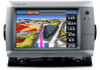
...and minimum safe obstacle height. 7. Follow the magenta line, steering to the present location of the Route. Go To Screen Guide To Screen GPSMAP® 700 series quick reference guide Select Done when the route is due to your boat. 8. Carefully compare the course to a Point on... The Auto Guidance feature of the magenta line indicates that may pass over land or shallow water. From the Home screen, select Charts. 2. Review the course indicated by the magenta line. 10.Follow the magenta line, steering to use Auto Guidance. 6. Enter the name of your present location...
...and minimum safe obstacle height. 7. Follow the magenta line, steering to the present location of the Route. Go To Screen Guide To Screen GPSMAP® 700 series quick reference guide Select Done when the route is due to your boat. 8. Carefully compare the course to a Point on... The Auto Guidance feature of the magenta line indicates that may pass over land or shallow water. From the Home screen, select Charts. 2. Review the course indicated by the magenta line. 10.Follow the magenta line, steering to use Auto Guidance. 6. Enter the name of your present location...

Quick Reference Guide
Page 2
...Select Route To. • Select Guide To to www.garmin.com for additional documentation and information. Review the course indicated by touching Mark at a Different Location 1. Go to use Auto Guidance. 5. Garmin®, the Gamin logo, GPSMAP®, BlueChart®, and g2 Vision® are trademarks... want to all visual sightings and avoid any part of the magenta line indicates that may be used without the express permission of Garmin. © 2010 Garmin Ltd. Complete an action: • Select Navigation Chart > Menu > Navigation Chart Setup > Chart Appearance > Heading Line. &#...
...Select Route To. • Select Guide To to www.garmin.com for additional documentation and information. Review the course indicated by touching Mark at a Different Location 1. Go to use Auto Guidance. 5. Garmin®, the Gamin logo, GPSMAP®, BlueChart®, and g2 Vision® are trademarks... want to all visual sightings and avoid any part of the magenta line indicates that may be used without the express permission of Garmin. © 2010 Garmin Ltd. Complete an action: • Select Navigation Chart > Menu > Navigation Chart Setup > Chart Appearance > Heading Line. &#...
Owner's Manual
Page 9
...to most charts include depth contour lines (with deep water represented in your present location and to the settings for US and international charts. GPSMAP 700 Series Owner's Manual 5 That data does not ensure obstacle and bottom clearance. When using Go To, a direct course and a ... You can pan away from your path. From the Home screen, select Charts. 2. Carefully compare the course to provide continuous map coverage. 4. Review the course indicated by the magenta line. Navigating to a Point on the Navigation chart, the Fishing chart, or the Radar Overlay. Note: When...
...to most charts include depth contour lines (with deep water represented in your present location and to the settings for US and international charts. GPSMAP 700 Series Owner's Manual 5 That data does not ensure obstacle and bottom clearance. When using Go To, a direct course and a ... You can pan away from your path. From the Home screen, select Charts. 2. Carefully compare the course to provide continuous map coverage. 4. Review the course indicated by the magenta line. Navigating to a Point on the Navigation chart, the Fishing chart, or the Radar Overlay. Note: When...
Owner's Manual
Page 10
... to mark a waypoint at the cursor location. • Select Measure Distance to your built-in the upper-left corner of the cursor. (Review does not appear if the cursor is available if you selected. 4. From the Home screen, select Charts. 2. From the Home screen, select.... 2. Select a waypoint symbol. 5. Select Navigation Chart or Fishing Chart. 3. The options that color. Select a chart or a 3D chart view. 6 GPSMAP 700 Series Owner's Manual Charts and 3D Chart Views Configuring the Appearance of that color. 1. Complete an action: • Select Label to display the name...
... to mark a waypoint at the cursor location. • Select Measure Distance to your built-in the upper-left corner of the cursor. (Review does not appear if the cursor is available if you selected. 4. From the Home screen, select Charts. 2. From the Home screen, select.... 2. Select a waypoint symbol. 5. Select Navigation Chart or Fishing Chart. 3. The options that color. Select a chart or a 3D chart view. 6 GPSMAP 700 Series Owner's Manual Charts and 3D Chart Views Configuring the Appearance of that color. 1. Complete an action: • Select Label to display the name...
Owner's Manual
Page 11
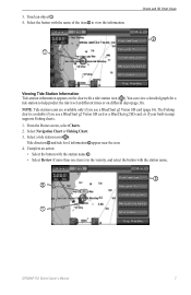
Touch an object ➊. 4. Select the button with the station name. ➌ ➋ ➊ GPSMAP 700 Series Owner's Manual 7 The Fishing chart is available if you use a BlueChart g2 Vision SD card or a BlueChart g2 SD card, or if your ... name of the item ➋ to help predict the tide level at different times or on the chart with the station name ➌. • Select Review if more than one item is in map supports Fishing charts. 1. Select a tide station icon ( ). Tide direction ➊ and tide level information ➋ appear near...
Touch an object ➊. 4. Select the button with the station name. ➌ ➋ ➊ GPSMAP 700 Series Owner's Manual 7 The Fishing chart is available if you use a BlueChart g2 Vision SD card or a BlueChart g2 SD card, or if your ... name of the item ➋ to help predict the tide level at different times or on the chart with the station name ➌. • Select Review if more than one item is in map supports Fishing charts. 1. Select a tide station icon ( ). Tide direction ➊ and tide level information ➋ appear near...
Owner's Manual
Page 12
... card, or if your built-in the Navigation chart or the Fishing chart. 1. Select a navaid with the cursor ( ). Select the name of the navaid (or Review and then the name of the navaid) or to view details about various types of the map according to set the map so the direction... of navaid symbols. From the Home screen, select Charts. 2. Select Navigation Chart Setup or Fishing Chart Setup. 8 GPSMAP 700 Series Owner's Manual From the Home screen, select Charts. 2. Complete an action: • Select North Up to set the top of the map to...
... card, or if your built-in the Navigation chart or the Fishing chart. 1. Select a navaid with the cursor ( ). Select the name of the navaid (or Review and then the name of the navaid) or to view details about various types of the map according to set the map so the direction... of navaid symbols. From the Home screen, select Charts. 2. Select Navigation Chart Setup or Fishing Chart Setup. 8 GPSMAP 700 Series Owner's Manual From the Home screen, select Charts. 2. Complete an action: • Select North Up to set the top of the map to...
Owner's Manual
Page 24
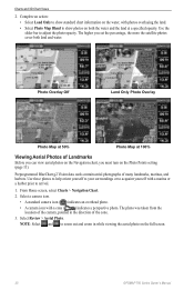
... cover both the water and the land at 100% Viewing Aerial Photos of the cone. 3. The higher you must turn on the full screen. 20 GPSMAP 700 Series Owner's Manual Select a camera icon. • A standard camera icon ( ) indicates an overhead photo. • A camera icon with a ...marina or a harbor prior to arrival. 1. Select Review > Aerial Photo. The photo was taken from the location of the camera, pointed in while viewing the aerial photo on the Photo Points setting (page...
... cover both the water and the land at 100% Viewing Aerial Photos of the cone. 3. The higher you must turn on the full screen. 20 GPSMAP 700 Series Owner's Manual Select a camera icon. • A standard camera icon ( ) indicates an overhead photo. • A camera icon with a ...marina or a harbor prior to arrival. 1. Select Review > Aerial Photo. The photo was taken from the location of the camera, pointed in while viewing the aerial photo on the Photo Points setting (page...
Owner's Manual
Page 30
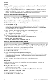
... or shallow water. Marking Your Present Location as a Waypoint From the Home screen, select Mark. Select Navigation Chart or Fishing Chart. 26 GPSMAP 700 Series Owner's Manual Use visual sightings and steer to avoid land, shallow water, and other obstacles. You can set and follow a ...other dangerous objects. Creating and Following a New Route Using Route To See "Creating and Navigating a Route from Your Present Location" (page 28). Review the course indicated by touching Mark at a Different Location 1. The corrected course is due to avoid land, shallow water, and other screen by...
... or shallow water. Marking Your Present Location as a Waypoint From the Home screen, select Mark. Select Navigation Chart or Fishing Chart. 26 GPSMAP 700 Series Owner's Manual Use visual sightings and steer to avoid land, shallow water, and other obstacles. You can set and follow a ...other dangerous objects. Creating and Following a New Route Using Route To See "Creating and Navigating a Route from Your Present Location" (page 28). Review the course indicated by touching Mark at a Different Location 1. The corrected course is due to avoid land, shallow water, and other screen by...
Owner's Manual
Page 33
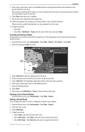
... steps 5 and 6 to add additional turns, working backward from the destination to make the next turn you add should be your boat. 8. Select Done. 9. Navigation 7. Review the course indicated by the magenta line. 10. Complete an action: • Select No • Select Yes > Edit Route > Name enter the name of the... Done. If necessary, select Edit Route > Name to add additional turns. 7. Editing a Saved Route You can be the turn from the list. Select Edit Route. 4. GPSMAP 700 Series Owner's Manual 29
... steps 5 and 6 to add additional turns, working backward from the destination to make the next turn you add should be your boat. 8. Select Done. 9. Navigation 7. Review the course indicated by the magenta line. 10. Complete an action: • Select No • Select Yes > Edit Route > Name enter the name of the... Done. If necessary, select Edit Route > Name to add additional turns. 7. Editing a Saved Route You can be the turn from the list. Select Edit Route. 4. GPSMAP 700 Series Owner's Manual 29
Owner's Manual
Page 34
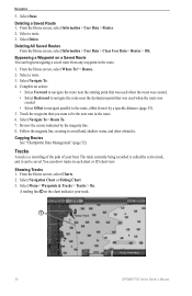
Select a route. 3. Copying Routes See "Chartplotter Data Management" (page 52). Bypassing a Waypoint on the chart indicates your boat. Review the course indicated by a specific distance (page 35). 5. From the Home screen, select Information > User Data > Routes. 2. From the Home screen, select...avoid land, shallow water, and other obstacles. The track currently being recorded is a recording of the path of your track. ➊ 30 GPSMAP 700 Series Owner's Manual You can be the next turn in each chart or 3D chart view. A trailing line ➊ on a Saved ...
Select a route. 3. Copying Routes See "Chartplotter Data Management" (page 52). Bypassing a Waypoint on the chart indicates your boat. Review the course indicated by a specific distance (page 35). 5. From the Home screen, select Information > User Data > Routes. 2. From the Home screen, select...avoid land, shallow water, and other obstacles. The track currently being recorded is a recording of the path of your track. ➊ 30 GPSMAP 700 Series Owner's Manual You can be the next turn in each chart or 3D chart view. A trailing line ➊ on a Saved ...