
Owners Manual
Page 2
...These trademarks may not be used without obligation to make changes in the content of Garmin. Mac® is a registered trademark of the National Marine Electronics Association. The Bluetooth® word mark and logos are registered trademarks of Microsoft Corporation in the U.S. Under... Bluetooth SIG, Inc. and other countries. NMEA®, NMEA 2000®, and the NMEA 2000 logo are owned by Garmin is ANT+® certified. Go to www.garmin.com for a list of Garmin Ltd. Garmin®, the Garmin logo, ANT+®, AutoLocate®, City Navigator®, GPSMAP&#...
...These trademarks may not be used without obligation to make changes in the content of Garmin. Mac® is a registered trademark of the National Marine Electronics Association. The Bluetooth® word mark and logos are registered trademarks of Microsoft Corporation in the U.S. Under... Bluetooth SIG, Inc. and other countries. NMEA®, NMEA 2000®, and the NMEA 2000 logo are owned by Garmin is ANT+® certified. Go to www.garmin.com for a list of Garmin Ltd. Garmin®, the Garmin logo, ANT+®, AutoLocate®, City Navigator®, GPSMAP&#...
Owners Manual
Page 3
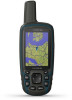
Table of Contents Introduction 1 Device Overviews 1 GPSMAP Device Overview (No Camera 1 GPSMAP Device Overview (Camera 1 Battery Information 1 Maximizing Battery Life 1 Turning On Battery Save Mode 1 Long-Term Storage 1 ... 6 Area Calculation 6 Calculating the Size of an Area 6 Satellite Page 6 GPS Satellite Settings 6 Garmin Adventures 7 Sending Files to BaseCamp 7 Creating an Adventure 7 Starting an Adventure 7 VIRB® Remote 7 Waypoint Averaging 7 Bluetooth Connected Features 7 Pairing a Smartphone with Your Device 7 Phone Notifications 7 Additional Main Menu Tools 8 ...
Table of Contents Introduction 1 Device Overviews 1 GPSMAP Device Overview (No Camera 1 GPSMAP Device Overview (Camera 1 Battery Information 1 Maximizing Battery Life 1 Turning On Battery Save Mode 1 Long-Term Storage 1 ... 6 Area Calculation 6 Calculating the Size of an Area 6 Satellite Page 6 GPS Satellite Settings 6 Garmin Adventures 7 Sending Files to BaseCamp 7 Creating an Adventure 7 Starting an Adventure 7 VIRB® Remote 7 Waypoint Averaging 7 Bluetooth Connected Features 7 Pairing a Smartphone with Your Device 7 Phone Notifications 7 Additional Main Menu Tools 8 ...
Owners Manual
Page 10
... at geocaching.com to geocaching.com, you can change activities, you can log your www.geocaching.com account automatically. When you enter an area with GPSMAP 64s/sc/st/sx/csx devices. Deleting a Photo 1 Select Photo Viewer. 2 Select a photo. 3 Select MENU > Delete > Yes. Logging the...for the cache or about the chirp, see the chirp Owner's Manual at www.garmin.com. NOTE: This feature is programmed and left in which players hide or search for hidden caches using Bluetooth® or ANT+® wireless technology. SOS Emergency strobe. Satellite Page The ...
... at geocaching.com to geocaching.com, you can change activities, you can log your www.geocaching.com account automatically. When you enter an area with GPSMAP 64s/sc/st/sx/csx devices. Deleting a Photo 1 Select Photo Viewer. 2 Select a photo. 3 Select MENU > Delete > Yes. Logging the...for the cache or about the chirp, see the chirp Owner's Manual at www.garmin.com. NOTE: This feature is programmed and left in which players hide or search for hidden caches using Bluetooth® or ANT+® wireless technology. SOS Emergency strobe. Satellite Page The ...
Owners Manual
Page 11
...with GPSMAP 64s/sc/st/sx/csx devices. 1 Bring your compatible smartphone within 10 m (33 ft.) of your device. 2 From the main menu on your device, select Setup > Bluetooth > Pair Mobile Device. 3 On your compatible smartphone, enable Bluetooth wireless technology, and search for all device models. Garmin ...enter the passkey. Creating an Adventure Before you to the waypoint location. 5 Select Start. 6 Follow the on the map. Bluetooth Connected Features Your GPSMAP 64s/sc/st/sx/csx device has several readings at least 90 minutes between samples. You can use this location to follow your...
...with GPSMAP 64s/sc/st/sx/csx devices. 1 Bring your compatible smartphone within 10 m (33 ft.) of your device. 2 From the main menu on your device, select Setup > Bluetooth > Pair Mobile Device. 3 On your compatible smartphone, enable Bluetooth wireless technology, and search for all device models. Garmin ...enter the passkey. Creating an Adventure Before you to the waypoint location. 5 Select Start. 6 Follow the on the map. Bluetooth Connected Features Your GPSMAP 64s/sc/st/sx/csx device has several readings at least 90 minutes between samples. You can use this location to follow your...
Owners Manual
Page 12
... on GPS. Minimum: The lowest elevation reached since the last reset. GPS Heading: The direction you are moving . Heading: The direction you travel . Select Setup > Bluetooth > Notifications > Hide. Ambient Pressure: The uncalibrated environmental pressure. Average: The average vertical distance of ascent since the last reset. Ascent - You must be navigating for...
... on GPS. Minimum: The lowest elevation reached since the last reset. GPS Heading: The direction you are moving . Heading: The direction you travel . Select Setup > Bluetooth > Notifications > Hide. Ambient Pressure: The uncalibrated environmental pressure. Average: The average vertical distance of ascent since the last reset. Ascent - You must be navigating for...
Owners Manual
Page 18
... 6 B backlight 1, 9, 10, 13 BaseCamp 7, 9, 12 battery 1, 12 charging 2 installing 1, 2 life 3 maximizing 1, 9, 10 storage 1 Bluetooth technology 7 C calculator 8 calendar 8 calibrating, altimeter 4 camera 5 settings 10 carabiner clip 11 charging 2 chirp 6 City Navigator 5 cleaning the device ... 8 deleting, all user data 12 device, registration 11 downloading, geocaches 6 E elevation 4 F files, transferring 6, 12 flashlight 6 G Garmin Connect 7 Garmin Express 11 updating software 11 geocaches 6, 12 downloading 6 GLONASS 9 GPS 6, 9 satellite page 6 settings 9 H HomePort 12 hunting and fishing...
... 6 B backlight 1, 9, 10, 13 BaseCamp 7, 9, 12 battery 1, 12 charging 2 installing 1, 2 life 3 maximizing 1, 9, 10 storage 1 Bluetooth technology 7 C calculator 8 calendar 8 calibrating, altimeter 4 camera 5 settings 10 carabiner clip 11 charging 2 chirp 6 City Navigator 5 cleaning the device ... 8 deleting, all user data 12 device, registration 11 downloading, geocaches 6 E elevation 4 F files, transferring 6, 12 flashlight 6 G Garmin Connect 7 Garmin Express 11 updating software 11 geocaches 6, 12 downloading 6 GLONASS 9 GPS 6, 9 satellite page 6 settings 9 H HomePort 12 hunting and fishing...

