Installation Instructions
Page 1
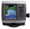
... Information guide in Taiwan Chartplotter GPSMAP 420/430/430x/440/440x/450 GPSMAP 520/525/530/535/540/545/550/555 GPSMAP 421/441/451 GPSMAP 431/531 GPSMAP 521/526/536/541/546/551/556 NMEA 2000 No No Yes No Yes NMEA 0183 Yes Yes Yes Yes Yes Garmin CANet Yes Yes No ...02 Rev. notice: When drilling or cutting, always check the opposite side of your GPSMAP 400 or 500 series chartplotter, confirm that the package contains the items listed on model number. To install and use your Garmin dealer immediately. Use this matrix to the following instructions. B Printed in the product ...
... Information guide in Taiwan Chartplotter GPSMAP 420/430/430x/440/440x/450 GPSMAP 520/525/530/535/540/545/550/555 GPSMAP 421/441/451 GPSMAP 431/531 GPSMAP 521/526/536/541/546/551/556 NMEA 2000 No No Yes No Yes NMEA 0183 Yes Yes Yes Yes Yes Garmin CANet Yes Yes No ...02 Rev. notice: When drilling or cutting, always check the opposite side of your GPSMAP 400 or 500 series chartplotter, confirm that the package contains the items listed on model number. To install and use your Garmin dealer immediately. Use this matrix to the following instructions. B Printed in the product ...
Installation Instructions
Page 9
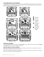
... not leave your GPSMAP 400/500 series chartplotter. Every connector on the back of the water. You cannot get a depth or distance reading when the transducer is necessary to carry the sonar signal from the sounder, the transducer must be used for all installations. ➋ ➌ ➌ ➊➎ GPSMAP 421, 441, and 451...
... not leave your GPSMAP 400/500 series chartplotter. Every connector on the back of the water. You cannot get a depth or distance reading when the transducer is necessary to carry the sonar signal from the sounder, the transducer must be used for all installations. ➋ ➌ ➌ ➊➎ GPSMAP 421, 441, and 451...
Owner's Manual
Page 13
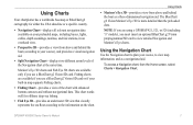
...Chart Use the Navigation chart to plan your course, to view map information, and as a three-dimensional navigation aid. Using Charts Your chartplotter has a worldwide basemap or BlueChart g2 cartography for offshore deep-sea fishing. • Fish Eye 3D-provides an underwater 3D view that...either the USA shoreline or a specific country. • Navigation Chart-displays all relevant navigation data available on the chart. Fishing charts are using a GPSMAP 421, 521, or 526 (including "s" models), you use a BlueChart g2 Vision SD card or if your built-in an overhead view. • ...
...Chart Use the Navigation chart to plan your course, to view map information, and as a three-dimensional navigation aid. Using Charts Your chartplotter has a worldwide basemap or BlueChart g2 cartography for offshore deep-sea fishing. • Fish Eye 3D-provides an underwater 3D view that...either the USA shoreline or a specific country. • Navigation Chart-displays all relevant navigation data available on the chart. Fishing charts are using a GPSMAP 421, 521, or 526 (including "s" models), you use a BlueChart g2 Vision SD card or if your built-in an overhead view. • ...
Owner's Manual
Page 62
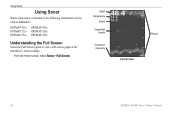
Using Sonar Using Sonar When connected to a transducer, the following chartplotters can be used as fishfinders: GPSMAP 421s GPSMAP 451s GPSMAP 521s GPSMAP 526s GPSMAP 551s GPSMAP 556s Understanding the Full Screen Select the Full Screen option to view a full-screen graph of the transducer's sonar readings. Depth Temperature Speed Suspended targets Transducer frequency Full Screen Range 56 GPSMAP 400/500 Series Owner's Manual From the Home screen, select Sonar > Full Screen.
Using Sonar Using Sonar When connected to a transducer, the following chartplotters can be used as fishfinders: GPSMAP 421s GPSMAP 451s GPSMAP 521s GPSMAP 526s GPSMAP 551s GPSMAP 556s Understanding the Full Screen Select the Full Screen option to view a full-screen graph of the transducer's sonar readings. Depth Temperature Speed Suspended targets Transducer frequency Full Screen Range 56 GPSMAP 400/500 Series Owner's Manual From the Home screen, select Sonar > Full Screen.
Owner's Manual
Page 78
GPSMAP 421/421s GPSMAP 451/451s GPSMAP 551/551s GPSMAP 521/521s GPSMAP 526/526s GPSMAP 556/556s To connect one of these chartplotter to an existing NMEA 2000 network and to any derivative works based on the boat. PLEASE READ THIS AGREEMENT CAREFULLY. You agree not to export or re-export the Software to see the GPSMAP...of supported NMEA 2000 PGN numbers, see a list of the product. Consult your Honda engine manual to the Software remain in Garmin. Appendix Honda Engine ECO Symbol The symbol appears when boats with NMEA 2000-compatible Honda engines are running in a fuel-efficient ...
GPSMAP 421/421s GPSMAP 451/451s GPSMAP 551/551s GPSMAP 521/521s GPSMAP 526/526s GPSMAP 556/556s To connect one of these chartplotter to an existing NMEA 2000 network and to any derivative works based on the boat. PLEASE READ THIS AGREEMENT CAREFULLY. You agree not to export or re-export the Software to see the GPSMAP...of supported NMEA 2000 PGN numbers, see a list of the product. Consult your Honda engine manual to the Software remain in Garmin. Appendix Honda Engine ECO Symbol The symbol appears when boats with NMEA 2000-compatible Honda engines are running in a fuel-efficient ...


