
Owners Manual
Page 2
..., Inc. Go to notify any use of the National Marine Electronics Association. ActiveCaptain®, ECHOMAP™, FUSION-Link™, Garmin ClearVü™, Garmin Connect™, Garmin Express™, Garmin Quickdraw™, GXM™, HomePort™, LiveScope™, OneChart™, and Panoptix™ ...countries. Under the copyright laws, this manual without obligation to www.garmin.com for current updates and supplemental information concerning the use of Garmin Ltd. Garmin reserves the right to make changes in the content of this manual may not be copied, in whole...
..., Inc. Go to notify any use of the National Marine Electronics Association. ActiveCaptain®, ECHOMAP™, FUSION-Link™, Garmin ClearVü™, Garmin Connect™, Garmin Express™, Garmin Quickdraw™, GXM™, HomePort™, LiveScope™, OneChart™, and Panoptix™ ...countries. Under the copyright laws, this manual without obligation to www.garmin.com for current updates and supplemental information concerning the use of Garmin Ltd. Garmin reserves the right to make changes in the content of this manual may not be copied, in whole...
Owners Manual
Page 3
... 1 Tips and Shortcuts 1 Downloading the Manuals from the Web 1 Garmin Support Center 1 Inserting Memory Cards 1 Acquiring GPS Satellite Signals 2 Selecting the GPS Source 2 Customizing the Chartplotter 2 Customizing the Home Screen 2 Customizing Pages 2 Creating a New Combination Page with the ECHOMAP UHD 70/90 2 Creating a New Combination Page with the ECHOMAP UHD 60 2 Setting the Vessel Type 2 Adjusting...
... 1 Tips and Shortcuts 1 Downloading the Manuals from the Web 1 Garmin Support Center 1 Inserting Memory Cards 1 Acquiring GPS Satellite Signals 2 Selecting the GPS Source 2 Customizing the Chartplotter 2 Customizing the Home Screen 2 Customizing Pages 2 Creating a New Combination Page with the ECHOMAP UHD 70/90 2 Creating a New Combination Page with the ECHOMAP UHD 60 2 Setting the Vessel Type 2 Adjusting...

Owners Manual
Page 7
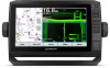
...; Press , and select Power > Turn Off Device, or hold until the Turn Off Device bar fills to garmin.com/manuals/ECHOMAPUHD. 2 Download the manual. Opens a shortcut menu to FAT32. Zooms out of a chart or view. ECHOMAP UHD 70/90 Front View Power key Automatic backlight sensor Touchscreen Shortcut keys microSD memory card slot Device Keys...
...; Press , and select Power > Turn Off Device, or hold until the Turn Off Device bar fills to garmin.com/manuals/ECHOMAPUHD. 2 Download the manual. Opens a shortcut menu to FAT32. Zooms out of a chart or view. ECHOMAP UHD 70/90 Front View Power key Automatic backlight sensor Touchscreen Shortcut keys microSD memory card slot Device Keys...

Owners Manual
Page 9
...available and you can also plan your mobile device settings. ActiveCaptain App CAUTION This feature allows users to the mobile device. Garmin makes no representations about data limits or charges. You can use the ActiveCaptain app to download and install the latest software...chartplotter display when paired. Any use the ActiveCaptain app to a specific waypoint or navigating a Yes Yes specific route Manually synchronize waypoints and routes with the ECHOMAP UHD device Yes Yes Getting Started with ActiveCaptain You can also adjust this network. 5 From the application store on ...
...available and you can also plan your mobile device settings. ActiveCaptain App CAUTION This feature allows users to the mobile device. Garmin makes no representations about data limits or charges. You can use the ActiveCaptain app to download and install the latest software...chartplotter display when paired. Any use the ActiveCaptain app to a specific waypoint or navigating a Yes Yes specific route Manually synchronize waypoints and routes with the ECHOMAP UHD device Yes Yes Getting Started with ActiveCaptain You can also adjust this network. 5 From the application store on ...
Owners Manual
Page 15
...of waypoints. When in sailing mode (Setting the Vessel Type, page 2), you must connect a wind sensor to display roses on the chart. The Manual option calculates the laylines using the measured wind angle from the bow of the boat in the boat's heading or true wind angle, enter a ...Shows sonar imagery to the heading of the laylines. Depth Range Shading You can create up to select how the device calculates laylines. Some Garmin LakeVü™ and premium supplemental charts have multiple depth range shading by your installed charts or your target fish are indicated by the ...
...of waypoints. When in sailing mode (Setting the Vessel Type, page 2), you must connect a wind sensor to display roses on the chart. The Manual option calculates the laylines using the measured wind angle from the bow of the boat in the boat's heading or true wind angle, enter a ...Shows sonar imagery to the heading of the laylines. Depth Range Shading You can create up to select how the device calculates laylines. Some Garmin LakeVü™ and premium supplemental charts have multiple depth range shading by your installed charts or your target fish are indicated by the ...

Owners Manual
Page 24
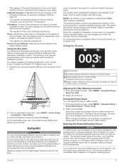
... appear on the chart, and sets the length of the water, depending on the autopilot when wind hold or . 18 Sailing Features The Manual option calculates the laylines using the measured wind angle from the bottom of the changes in the boat's heading or true wind angle, enter ...Autopilot You can set a layline based on the tide. Adjusting the Wind Hold Angle with your needs. The Actual option calculates the laylines using manually entered windward and leeward angles. If you must connect a NMEA 2000 or NMEA 0183 wind sensor to the autopilot. Engaging Wind Hold Before ...
... appear on the chart, and sets the length of the water, depending on the autopilot when wind hold or . 18 Sailing Features The Manual option calculates the laylines using the measured wind angle from the bottom of the changes in the boat's heading or true wind angle, enter ...Autopilot You can set a layline based on the tide. Adjusting the Wind Hold Angle with your needs. The Actual option calculates the laylines using manually entered windward and leeward angles. If you must connect a NMEA 2000 or NMEA 0183 wind sensor to the autopilot. Engaging Wind Hold Before ...

Owners Manual
Page 25
...can engage wind hold, you must have a compatible Panoptix transducer connected. Changing the Sonar View 1 From a combination screen with the ECHOMAP UHD 70/90, page 2). These beams provide a clearer, picture-like image of different frequencies. Enabling the Gybe Inhibitor NOTE: The .... Stopping the Transmission of Sonar Signals • To disable the active sonar, from manually performing a gybe using the helm or step steering. Traditional transducers emit a conical beam. The Garmin ClearVü scanning sonar technology emits two narrow beams, similar to change. 3 Select...
...can engage wind hold, you must have a compatible Panoptix transducer connected. Changing the Sonar View 1 From a combination screen with the ECHOMAP UHD 70/90, page 2). These beams provide a clearer, picture-like image of different frequencies. Enabling the Gybe Inhibitor NOTE: The .... Stopping the Transmission of Sonar Signals • To disable the active sonar, from manually performing a gybe using the helm or step steering. Traditional transducers emit a conical beam. The Garmin ClearVü scanning sonar technology emits two narrow beams, similar to change. 3 Select...

Owners Manual
Page 29
...on the sonar screen either by adjusting the gain for Garmin ClearVü and SideVü/ClearVü transducers. For example, from one ECHOMAP UHD 92sv device mounted at the front of time the information is available for Garmin ClearVü transducers. In addition, the scroll rates of... or decrease the color intensity manually, select Up or Down. • To use the default setting, select Default. This setting works best after it more information on your device list. 5 Right-click the sonar recording in another ECHOMAP UHD device and Garmin ClearVü transducer mounted at...
...on the sonar screen either by adjusting the gain for Garmin ClearVü and SideVü/ClearVü transducers. For example, from one ECHOMAP UHD 92sv device mounted at the front of time the information is available for Garmin ClearVü transducers. In addition, the scroll rates of... or decrease the color intensity manually, select Up or Down. • To use the default setting, select Default. This setting works best after it more information on your device list. 5 Right-click the sonar recording in another ECHOMAP UHD device and Garmin ClearVü transducer mounted at...
Owners Manual
Page 30
...Zoom In or Zoom Out to increase or decrease the magnification of the magnified area. • To magnify one particular area of the magnified area manually, select Manual > , select View Up or View Down to set the rate at which can help you are available on all sizes are detected. •...8226; To scroll faster, select Up. • To scroll more options. • To set the depth range of the screen, select Magnify. When viewing Garmin ClearVü or SideVü sonar views or searching for weakened sonar signals in deeper water, and reduces the appearance of the sonar screen, and...
...Zoom In or Zoom Out to increase or decrease the magnification of the magnified area. • To magnify one particular area of the magnified area manually, select Manual > , select View Up or View Down to set the rate at which can help you are available on all sizes are detected. •...8226; To scroll faster, select Up. • To scroll more options. • To set the depth range of the screen, select Magnify. When viewing Garmin ClearVü or SideVü sonar views or searching for weakened sonar signals in deeper water, and reduces the appearance of the sonar screen, and...

Owners Manual
Page 32
... shows the depth at the bottom. When this option can appear on the screen as long as the PS30, PS31, and PS60. Manually adjusting the range enables you to effectively avoid running aground with RealVü capable Panoptix transducers, such as it more coverage area. CAUTION...the sonar return points. The trails show the movement of the depths the colors represent. screen. Allowing the device to recognize actual returns. Manually reducing this setting is less than the specified value (Setting the FrontVü Depth Alarm, page 26). FrontVü Alarm: Sets an...
... shows the depth at the bottom. When this option can appear on the screen as long as the PS30, PS31, and PS60. Manually adjusting the range enables you to effectively avoid running aground with RealVü capable Panoptix transducers, such as it more coverage area. CAUTION...the sonar return points. The trails show the movement of the depths the colors represent. screen. Allowing the device to recognize actual returns. Manually reducing this setting is less than the specified value (Setting the FrontVü Depth Alarm, page 26). FrontVü Alarm: Sets an...
Owners Manual
Page 33
... default values. This feature applies to Panoptix transducers in water. The system also allows manual steering and several modes of your preferred source. For information about compatible Garmin autopilot systems, go to the bow. Adjusting the Step Steering Increment 1 From the Autopilot... and helm control device. Autopilot 27 Orientation: Controls if the transducer is a tool that enhances your capability to promptly regain manual control of navigation data and speed source periodically. This applies to maintain a constant heading (heading hold). Setting the Bow Offset ...
... default values. This feature applies to Panoptix transducers in water. The system also allows manual steering and several modes of your preferred source. For information about compatible Garmin autopilot systems, go to the bow. Adjusting the Step Steering Increment 1 From the Autopilot... and helm control device. Autopilot 27 Orientation: Controls if the transducer is a tool that enhances your capability to promptly regain manual control of navigation data and speed source periodically. This applies to maintain a constant heading (heading hold). Setting the Bow Offset ...

Owners Manual
Page 37
...vessel when you can set an alarm to Boat, and enter the amount added. To view the information, a compatible transducer or sensor must manually select the number of engines (Selecting the Number of engines. Select Gauges > Compass. Select Gauges > Engine. Customizing the Engines Shown in the... alarm. The chartplotter sends information about the call to the radio. 6 On your Garmin VHF radio, complete the call . The chartplotter sends information about the call to the radio. 5 On your Garmin VHF radio, complete the call . You can customize how the engines are shown in...
...vessel when you can set an alarm to Boat, and enter the amount added. To view the information, a compatible transducer or sensor must manually select the number of engines (Selecting the Number of engines. Select Gauges > Compass. Select Gauges > Engine. Customizing the Engines Shown in the... alarm. The chartplotter sends information about the call to the radio. 6 On your Garmin VHF radio, complete the call . The chartplotter sends information about the call to the radio. 5 On your Garmin VHF radio, complete the call . You can customize how the engines are shown in...

Owners Manual
Page 38
... Tides & Currents. 2 Select Tides, Currents, or Celestial. 3 Select an option: • To view information for a different date, select Change Date > Manual, and enter a date. • To view information for today, select Change Date > Use Current Date. • If available, to view information for the ...horizon. Select Gauges > Wind. NOTE: When moving at low speeds or when stationary, the magnetic compass source is calculated by your Garmin dealer. Tide, Current, and Celestial Information Tide Station Information You can view information about a tide station for a specific date and ...
... Tides & Currents. 2 Select Tides, Currents, or Celestial. 3 Select an option: • To view information for a different date, select Change Date > Manual, and enter a date. • To view information for today, select Change Date > Use Current Date. • If available, to view information for the ...horizon. Select Gauges > Wind. NOTE: When moving at low speeds or when stationary, the magnetic compass source is calculated by your Garmin dealer. Tide, Current, and Celestial Information Tide Station Information You can view information about a tide station for a specific date and ...

Owners Manual
Page 47
... the power cable for at least 12 V. Updating the Device Software Before you can update the software, you are on a Mac computer, copy the Garmin folder to any screen shown on the memory card. 3 Copy a .bmp file from the chartplotter, and insert it into the card slot. 2...Follow the on the cable or the installation instructions for longer than 12 V, the device will not turn on, contact Garmin product support. Changing the Fuse in place and restart the chartplotter manually. 6 Remove the memory card. Capturing Screenshots 1 Insert a memory card into a card reader that it to the ...
... the power cable for at least 12 V. Updating the Device Software Before you can update the software, you are on a Mac computer, copy the Garmin folder to any screen shown on the memory card. 3 Copy a .bmp file from the chartplotter, and insert it into the card slot. 2...Follow the on the cable or the installation instructions for longer than 12 V, the device will not turn on, contact Garmin product support. Changing the Fuse in place and restart the chartplotter manually. 6 Remove the memory card. Capturing Screenshots 1 Insert a memory card into a card reader that it to the ...
Owners Manual
Page 48
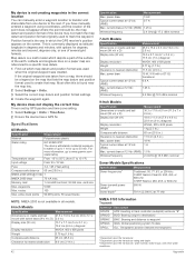
... in .) 18 W 1 A 1.5 A 2.4 GHz @ 18.5 dBm nominal Sonar Models Specifications Specification Sonar frequencies1 Measurement Traditional: 50, 77, 83, or 200 kHz CHIRP Garmin ClearVü: 260, 455, or 800 kHz CHIRP SideVü: 260, 455, or 800 kHz Sonar transmit power (RMS)2 Sonar depth3 500 W 701 m (2,300 ft...again. Latitude and longitude lines on cradle and bail mount with options for up to www.garmin.com /waterrating. Most often this is not creating waypoints in the correct location You can manually enter a waypoint location to transfer and share data from 5° to 131°F) ...
... in .) 18 W 1 A 1.5 A 2.4 GHz @ 18.5 dBm nominal Sonar Models Specifications Specification Sonar frequencies1 Measurement Traditional: 50, 77, 83, or 200 kHz CHIRP Garmin ClearVü: 260, 455, or 800 kHz CHIRP SideVü: 260, 455, or 800 kHz Sonar transmit power (RMS)2 Sonar depth3 500 W 701 m (2,300 ft...again. Latitude and longitude lines on cradle and bail mount with options for up to www.garmin.com /waterrating. Most often this is not creating waypoints in the correct location You can manually enter a waypoint location to transfer and share data from 5° to 131°F) ...