
Important Safety and Product Information
Page 2
...HOW LONG AN IMPLIED WARRANTY LASTS, SO THE ABOVE LIMITATION MAY NOT APPLY TO YOU. Before seeking warranty service, please access and review the online help . Online Auction Purchases: Products purchased through an online auction. You are entitled to a replacement or refund for ... MAXIMUM EXTENT PERMITTED BY APPLICABLE LAW, THE WARRANTIES AND REMEDIES CONTAINED IN THIS LIMITED WARRANTY ARE EXCLUSIVE AND IN LIEU OF, AND GARMIN EXPRESSLY DISCLAIMS, ALL OTHER WARRANTIES AND REMEDIES, WHETHER EXPRESS, IMPLIED, STATUTORY, OR OTHERWISE, INCLUDING WITHOUT LIMITATION ANY IMPLIED WARRANTY OF ...
...HOW LONG AN IMPLIED WARRANTY LASTS, SO THE ABOVE LIMITATION MAY NOT APPLY TO YOU. Before seeking warranty service, please access and review the online help . Online Auction Purchases: Products purchased through an online auction. You are entitled to a replacement or refund for ... MAXIMUM EXTENT PERMITTED BY APPLICABLE LAW, THE WARRANTIES AND REMEDIES CONTAINED IN THIS LIMITED WARRANTY ARE EXCLUSIVE AND IN LIEU OF, AND GARMIN EXPRESSLY DISCLAIMS, ALL OTHER WARRANTIES AND REMEDIES, WHETHER EXPRESS, IMPLIED, STATUTORY, OR OTHERWISE, INCLUDING WITHOUT LIMITATION ANY IMPLIED WARRANTY OF ...
Owners Manual
Page 11
... options appears along the heading line. Angle markers indicate relative position from a connected heading sensor, select Heading. • To use Auto Guidance, select Auto Guidance. 4 Review the course indicated by the magenta line. COG is due to the settings for casting or finding reference points. Carefully compare the course to avoid...
... options appears along the heading line. Angle markers indicate relative position from a connected heading sensor, select Heading. • To use Auto Guidance, select Auto Guidance. 4 Review the course indicated by the magenta line. COG is due to the settings for casting or finding reference points. Carefully compare the course to avoid...

Owners Manual
Page 14
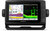
... Chart, page 6). The chartplotter can receive signals from AIS vessel targeting and tracking, and the display of the charts. Select Review > Go To to those settings, the changes will not impact the chart view. Some options require premium maps or connected accessories...To receive or ignore Search and Rescue Transponder (SART) test signals, select AIS-SART Test. Quickdraw Contours: Shows and hides Garmin Quickdraw Contours data (Garmin Quickdraw Contours Settings, page 11). Service Points: Shows locations for marine services. 8 Charts and 3D Chart Views Distress signal ...
... Chart, page 6). The chartplotter can receive signals from AIS vessel targeting and tracking, and the display of the charts. Select Review > Go To to those settings, the changes will not impact the chart view. Some options require premium maps or connected accessories...To receive or ignore Search and Rescue Transponder (SART) test signals, select AIS-SART Test. Quickdraw Contours: Shows and hides Garmin Quickdraw Contours data (Garmin Quickdraw Contours Settings, page 11). Service Points: Shows locations for marine services. 8 Charts and 3D Chart Views Distress signal ...

Owners Manual
Page 18
... magenta line is unsafe, reduce your location to a destination, allowing you directly to -steer arrow, which I change the Auto See (Auto Guidance, page 14). WARNING Review the path for saved waypoints, saved routes, saved tracks, and marine services destinations by name. 1 Select Nav Info > Search by Name You can also use... the orange course-to the destination. If the path is a thinner purple line that support Auto Guidance and are using a compatible Garmin autopilot connected to the destination. You can follow the course or route.
... magenta line is unsafe, reduce your location to a destination, allowing you directly to -steer arrow, which I change the Auto See (Auto Guidance, page 14). WARNING Review the path for saved waypoints, saved routes, saved tracks, and marine services destinations by name. 1 Select Nav Info > Search by Name You can also use... the orange course-to the destination. If the path is a thinner purple line that support Auto Guidance and are using a compatible Garmin autopilot connected to the destination. You can follow the course or route.

Owners Manual
Page 19
... projecting the distance and bearing from one or more destinations. Moving a Saved Waypoint 1 Select Nav Info > Waypoints. 2 Select a waypoint. 3 Select Review > Move. 4 Indicate a new location for minimum safe water depth and minimum safe obstacle height. 6 Follow the magenta line, steering to the present ...location of your vessel. 6 If necessary, select MENU. 7 Select SELECT > Done. 8 Review the course indicated by the magenta line. 9 Follow the magenta line, steering to one location to avoid land, shallow water, and other obstacles ...
... projecting the distance and bearing from one or more destinations. Moving a Saved Waypoint 1 Select Nav Info > Waypoints. 2 Select a waypoint. 3 Select Review > Move. 4 Indicate a new location for minimum safe water depth and minimum safe obstacle height. 6 Follow the magenta line, steering to the present ...location of your vessel. 6 If necessary, select MENU. 7 Select SELECT > Done. 8 Review the course indicated by the magenta line. 9 Follow the magenta line, steering to one location to avoid land, shallow water, and other obstacles ...

Owners Manual
Page 20
... suggested path. Starboard. 6 If necessary, select Done. Deleting a Saved Route 1 Select Nav Info > Routes. 2 Select a route. 3 Select Review > Delete. Auto Guidance uses your destination. Port. • To navigate the route from the destination point used when the route was created, to ...precisely followed. Setting and Following an Auto Guidance Path 1 Select a destination (Destinations, page 12). 2 Select Navigate To > Auto Guidance. 3 Review the path, indicated by the magenta line. 4 Select Start Navigation. 5 Follow the magenta line, steering to avoid land, shallow water, and other...
... suggested path. Starboard. 6 If necessary, select Done. Deleting a Saved Route 1 Select Nav Info > Routes. 2 Select a route. 3 Select Review > Delete. Auto Guidance uses your destination. Port. • To navigate the route from the destination point used when the route was created, to ...precisely followed. Setting and Following an Auto Guidance Path 1 Select a destination (Destinations, page 12). 2 Select Navigate To > Auto Guidance. 3 Review the path, indicated by the magenta line. 4 Select Start Navigation. 5 Follow the magenta line, steering to avoid land, shallow water, and other...

Owners Manual
Page 21
... available with a Chartplotter 15 On the chart, the course through a narrow waterway (Adjusting the Distance from obstacles in step 8, review the placement of an Auto Guidance path is shallower than the Preferred Depth or lower than 3 feet, the charts only use this... > Auto Guidance > Shoreline Distance > Normal. 3 Select a destination that you have navigated to previously. 4 Select Navigate To > Auto Guidance. 5 Review the placement of the Auto Guidance line, and determine whether the line safely avoids known obstacles and the turns enable efficient travel over. NOTE: The...
... available with a Chartplotter 15 On the chart, the course through a narrow waterway (Adjusting the Distance from obstacles in step 8, review the placement of an Auto Guidance path is shallower than the Preferred Depth or lower than 3 feet, the charts only use this... > Auto Guidance > Shoreline Distance > Normal. 3 Select a destination that you have navigated to previously. 4 Select Navigate To > Auto Guidance. 5 Review the placement of the Auto Guidance line, and determine whether the line safely avoids known obstacles and the turns enable efficient travel over. NOTE: The...

Owners Manual
Page 22
... Info > Tracks > Save Active Track. 2 Select an option: • Select the time the active track began . • Select Entire Log. 3 Review the course indicated by the colored line. 6 Follow the line along each leg in each time, until the track memory is the recommended recording option...You can create a boundary area using waypoints by creating a route from the destination point used when the track was created, select Backward. 5 Review the course indicated by the colored line. 4 Follow the colored line, steering to avoid land, shallow water, and other obstacles. Retracing the ...
... Info > Tracks > Save Active Track. 2 Select an option: • Select the time the active track began . • Select Entire Log. 3 Review the course indicated by the colored line. 6 Follow the line along each leg in each time, until the track memory is the recommended recording option...You can create a boundary area using waypoints by creating a route from the destination point used when the track was created, select Backward. 5 Review the course indicated by the colored line. 4 Follow the colored line, steering to avoid land, shallow water, and other obstacles. Retracing the ...