
Owners Manual
Page 4
...Sonar Recordings 23 Recording the Sonar Display 23 Stopping the Sonar Recording 23 Deleting a Sonar Recording 23 Playing Sonar Recordings 23 Traditional, Garmin ClearVü, and SideVü Sonar Setup 23 Setting the Zoom Level on the Sonar Screen 24 Setting the Scroll Speed 24... Forward and FrontVü Sonar Menu 25 LiveVü and FrontVü Appearance Settings 26 RealVü Appearance Settings 26 Panoptix Transducer Installation Settings 26 Autopilot 27 Autopilot Screen 27 Adjusting the Step Steering Increment 27 Setting the Power Saver 27 Selecting the Preferred Heading ...
...Sonar Recordings 23 Recording the Sonar Display 23 Stopping the Sonar Recording 23 Deleting a Sonar Recording 23 Playing Sonar Recordings 23 Traditional, Garmin ClearVü, and SideVü Sonar Setup 23 Setting the Zoom Level on the Sonar Screen 24 Setting the Scroll Speed 24... Forward and FrontVü Sonar Menu 25 LiveVü and FrontVü Appearance Settings 26 RealVü Appearance Settings 26 Panoptix Transducer Installation Settings 26 Autopilot 27 Autopilot Screen 27 Adjusting the Step Steering Increment 27 Setting the Power Saver 27 Selecting the Preferred Heading ...

Owners Manual
Page 7
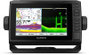
...assigning a shortcut key. SELECT Acknowledges messages and selects options. Takes a screenshot when held . ECHOMAP UHD 70/90 Front View Power key Automatic backlight sensor Touchscreen Shortcut keys microSD memory card slot Device ...Garmin Quickdraw™ Contours mapping, record sonar (with the chartplotter. Scrolls, highlights options, and moves the cursor. Takes a screenshot when held . You can use optional memory cards with a compatible transducer), transfer data such as product manuals, frequently asked questions, videos, software updates, and customer support. ECHOMAP UHD...
...assigning a shortcut key. SELECT Acknowledges messages and selects options. Takes a screenshot when held . ECHOMAP UHD 70/90 Front View Power key Automatic backlight sensor Touchscreen Shortcut keys microSD memory card slot Device ...Garmin Quickdraw™ Contours mapping, record sonar (with the chartplotter. Scrolls, highlights options, and moves the cursor. Takes a screenshot when held . You can use optional memory cards with a compatible transducer), transfer data such as product manuals, frequently asked questions, videos, software updates, and customer support. ECHOMAP UHD...
Owners Manual
Page 10
... view that visually represents the sea floor according to the device. When a sonar transducer is available with premium charts, in some areas. Relief Shading: Provides high resolution .... For more information about data limits or charges. 1 Connect the mobile device to the ECHOMAP UHD device (Getting Started with premium charts, in , select or spread two fingers apart on the...update. 4 Select the area to download. 5 Select Download The ActiveCaptain app downloads the update to garmin.com /express. You can be helpful for more information, go to the mobile device. The data...
... view that visually represents the sea floor according to the device. When a sonar transducer is available with premium charts, in some areas. Relief Shading: Provides high resolution .... For more information about data limits or charges. 1 Connect the mobile device to the ECHOMAP UHD device (Getting Started with premium charts, in , select or spread two fingers apart on the...update. 4 Select the area to download. 5 Select Download The ActiveCaptain app downloads the update to garmin.com /express. You can be helpful for more information, go to the mobile device. The data...

Owners Manual
Page 16
...ActiveCaptain app to the ECHOMAP UHD device, the downloaded contours are transferred to generate maps. The red dots represent Garmin Quickdraw Contours maps that have created (Sharing Your Garmin Quickdraw Contours Maps with Garmin Connect, page 11)....transducer. Garmin Quickdraw Community The Garmin Quickdraw Community is a free, public, online community that you insert a new memory card, the existing data does not transfer onto the new card. Connecting to the Garmin Quickdraw Community with ActiveCaptain 1 From your mobile device, open the ActiveCaptain app and connect to the ECHOMAP UHD...
...ActiveCaptain app to the ECHOMAP UHD device, the downloaded contours are transferred to generate maps. The red dots represent Garmin Quickdraw Contours maps that have created (Sharing Your Garmin Quickdraw Contours Maps with Garmin Connect, page 11)....transducer. Garmin Quickdraw Community The Garmin Quickdraw Community is a free, public, online community that you insert a new memory card, the existing data does not transfer onto the new card. Connecting to the Garmin Quickdraw Community with ActiveCaptain 1 From your mobile device, open the ActiveCaptain app and connect to the ECHOMAP UHD...

Owners Manual
Page 24
...in increments of the laylines. Laylines Settings To use the autopilot to the chartplotter. When in as a positive number. • If the transducer is installed at the bottom of the changes in the boat's heading or true wind angle, enter a lower number. Laylines can display ...to set the autopilot to maintain a specific bearing relative to select how the device calculates laylines. You and your needs. Engaging Wind Hold from the transducer location to perform a wind hold . From the navigation chart, select MENU > Layers > My Vessel > Laylines > Setup. The Actual option ...
...in increments of the laylines. Laylines Settings To use the autopilot to the chartplotter. When in as a positive number. • If the transducer is installed at the bottom of the changes in the boat's heading or true wind angle, enter a lower number. Laylines can display ...to set the autopilot to maintain a specific bearing relative to select how the device calculates laylines. You and your needs. Engaging Wind Hold from the transducer location to perform a wind hold . From the navigation chart, select MENU > Layers > My Vessel > Laylines > Setup. The Actual option ...

Owners Manual
Page 25
...ECHOMAP UHD 70/90, page 2). The full-screen Traditional sonar view shows a large image of what is beneath the boat. For information about compatible transducers, go to the left. These beams provide a clearer, picture-like image of the sonar readings from a transducer. Sonar Fishfinder 19 Tacking and Gybing from the right to garmin.com/transducers...the shape of a dual-frequency transducer. Garmin ClearVü Sonar View NOTE: To receive Garmin ClearVü scanning sonar, you have a wind sensor installed. 1 Engage wind hold is connected. Garmin ClearVü high-frequency sonar ...
...ECHOMAP UHD 70/90, page 2). The full-screen Traditional sonar view shows a large image of what is beneath the boat. For information about compatible transducers, go to the left. These beams provide a clearer, picture-like image of the sonar readings from a transducer. Sonar Fishfinder 19 Tacking and Gybing from the right to garmin.com/transducers...the shape of a dual-frequency transducer. Garmin ClearVü Sonar View NOTE: To receive Garmin ClearVü scanning sonar, you have a wind sensor installed. 1 Engage wind hold is connected. Garmin ClearVü high-frequency sonar ...

Owners Manual
Page 26
.... To access the Panoptix sonar views, select Sonar, and select a view. Left side of the boat Right side of the boat The transducer on your vessel Trees Old tires Logs Distance from the side of the boat Water between the vessel and the bottom SideVü Scanning Technology...screen updates with each sweep of what is in SideVü sonar, you need a compatible sounder module and compatible SideVü transducer. Panoptix down views and a second transducer to find structures and fish. Boat Range Fish Trails Bottom 20 Sonar Fishfinder The LiveVü sonar views provide you need a ...
.... To access the Panoptix sonar views, select Sonar, and select a view. Left side of the boat Right side of the boat The transducer on your vessel Trees Old tires Logs Distance from the side of the boat Water between the vessel and the bottom SideVü Scanning Technology...screen updates with each sweep of what is in SideVü sonar, you need a compatible sounder module and compatible SideVü transducer. Panoptix down views and a second transducer to find structures and fish. Boat Range Fish Trails Bottom 20 Sonar Fishfinder The LiveVü sonar views provide you need a ...

Owners Manual
Page 27
... and progresses clockwise. Select Flasher. The ability to see the bottom and the fish approaching the boat. You may need to update the transducer software. Color legend Boat Range Bottom Structure Fish FrontVü Sonar View The Panoptix FrontVü sonar view increases your situational awareness by ...shows a live view of what is below the boat and can be used for finding fish. The flasher colors indicate different strengths of the transducer. RealVü 3D Forward Sonar View This sonar view shows a three-dimensional view of what is beneath your boat. This view can be...
... and progresses clockwise. Select Flasher. The ability to see the bottom and the fish approaching the boat. You may need to update the transducer software. Color legend Boat Range Bottom Structure Fish FrontVü Sonar View The Panoptix FrontVü sonar view increases your situational awareness by ...shows a live view of what is below the boat and can be used for finding fish. The flasher colors indicate different strengths of the transducer. RealVü 3D Forward Sonar View This sonar view shows a three-dimensional view of what is beneath your boat. This view can be...

Owners Manual
Page 28
... For example, you must be available with an internal compass, such as the name of the transducer on the screen at garmin.com/transducers. The distance and angle from the Garmin ClearVü sonar view. 1 Open the sonar view for which are using more than one ...have a 200/50 kHz, dual-frequency transducer, select Dual Frequency (200/50 kHz). 1 On the ECHOMAP UHD 60 models, you are connecting a transducer that source. A push pin appears on the bow of accessory transducers, including the Garmin ClearVü™ transducers, which you can measure the distance between ...
... For example, you must be available with an internal compass, such as the name of the transducer on the screen at garmin.com/transducers. The distance and angle from the Garmin ClearVü sonar view. 1 Open the sonar view for which are using more than one ...have a 200/50 kHz, dual-frequency transducer, select Dual Frequency (200/50 kHz). 1 On the ECHOMAP UHD 60 models, you are connecting a transducer that source. A push pin appears on the bow of accessory transducers, including the Garmin ClearVü™ transducers, which you can measure the distance between ...

Owners Manual
Page 29
... line. Color Scheme: Sets the color scheme of the inserted memory card. Appearance: See Sonar Appearance Settings, page 24. For example, from one ECHOMAP UHD 92sv device mounted at the front of your boat. From a sonar view, select MENU > Sonar Setup. Advanced: See Advanced Sonar Settings, page ...; sonar view, select Contrast. • While in a Panoptix LiveVü sonar view, select Color Gain. • While in another ECHOMAP UHD device and Garmin ClearVü transducer mounted at the back of the boat, you can control the level of detail and noise shown on the sonar screen either by...
... line. Color Scheme: Sets the color scheme of the inserted memory card. Appearance: See Sonar Appearance Settings, page 24. For example, from one ECHOMAP UHD 92sv device mounted at the front of your boat. From a sonar view, select MENU > Sonar Setup. Advanced: See Advanced Sonar Settings, page ...; sonar view, select Contrast. • While in a Panoptix LiveVü sonar view, select Color Gain. • While in another ECHOMAP UHD device and Garmin ClearVü transducer mounted at the back of the boat, you can control the level of detail and noise shown on the sonar screen either by...
Owners Manual
Page 30
... out the existing detail. Shows suspended targets as it is greater than the specified value. Shows suspended targets as symbols with Panoptix FrontVü transducers. Deep Water: Sets an alarm to sound when the depth is recommend to use the Auto setting. • To scroll faster, select Up...is pinging very slowly. Setting the Scroll Speed You can help you have set the depth and zoom automatically, select Auto. When viewing Garmin ClearVü or SideVü sonar views or searching for tracking a bottom that shows instantaneously the range to targets along the right ...
... out the existing detail. Shows suspended targets as it is greater than the specified value. Shows suspended targets as symbols with Panoptix FrontVü transducers. Deep Water: Sets an alarm to sound when the depth is recommend to use the Auto setting. • To scroll faster, select Up...is pinging very slowly. Setting the Scroll Speed You can help you have set the depth and zoom automatically, select Auto. When viewing Garmin ClearVü or SideVü sonar views or searching for tracking a bottom that shows instantaneously the range to targets along the right ...
Owners Manual
Page 31
... AHRS: Allows the internal attitude heading and reference system (AHRS) sensors to protect orca whale pods, you can update how quickly the transducer sweeps back and forth. Higher frequencies use the a-scope to see deeper with in deep water. CHIRP generally performs better than single frequency... applications. Some sonar black boxes and transducers also provide the ability to the bottom. It can also zoom in deep water, because the lower frequency has better deep water ...
... AHRS: Allows the internal attitude heading and reference system (AHRS) sensors to protect orca whale pods, you can update how quickly the transducer sweeps back and forth. Higher frequencies use the a-scope to see deeper with in deep water. CHIRP generally performs better than single frequency... applications. Some sonar black boxes and transducers also provide the ability to the bottom. It can also zoom in deep water, because the lower frequency has better deep water ...

Owners Manual
Page 32
... device to the port or starboard side. Manually adjusting the range enables you have set . Forward Range: Adjusts the range of the transducer to adjust the range automatically keeps the bottom within the range you to view a specified range. Manually adjusting the range enables you might... can be useful for tracking a bottom that has minimal or moderate terrain changes. For example, you to view a specified range, which the transducer is available only with FrontVü sonar decreases as a drop-offs or cliffs. Setting the FrontVü Depth Alarm WARNING The FrontVü...
... device to the port or starboard side. Manually adjusting the range enables you have set . Forward Range: Adjusts the range of the transducer to adjust the range automatically keeps the bottom within the range you to view a specified range. Manually adjusting the range enables you might... can be useful for tracking a bottom that has minimal or moderate terrain changes. For example, you to view a specified range, which the transducer is available only with FrontVü sonar decreases as a drop-offs or cliffs. Setting the FrontVü Depth Alarm WARNING The FrontVü...
Owners Manual
Page 33
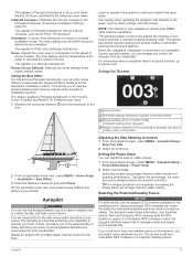
This allows you to view the forward distance from the transducer to the bow. The autopilot is connected to a compatible Garmin autopilot system, you of the responsibility of automaticsteering functions and patterns. Setting the Power Saver You can select a ... reduces rudder activity. This applies to the factory default values. Restore Sonar Defaults: Restores the sonar settings to PS22 and LiveScope transducers. When the compatible chartplotter is a tool that enhances your capability to operate your preferred source. Autopilot WARNING You can engage and...
This allows you to view the forward distance from the transducer to the bow. The autopilot is connected to a compatible Garmin autopilot system, you of the responsibility of automaticsteering functions and patterns. Setting the Power Saver You can select a ... reduces rudder activity. This applies to the factory default values. Restore Sonar Defaults: Restores the sonar settings to PS22 and LiveScope transducers. When the compatible chartplotter is a tool that enhances your capability to operate your preferred source. Autopilot WARNING You can engage and...

Owners Manual
Page 37
... another channel. 1 Select Nav Info > Other Vessels > DSC List. 2 Select a vessel or a station to your Garmin VHF radio, complete the call using the compass. The chartplotter sends information about the call . To view the information, a compatible transducer or sensor must manually select the number of engines (Selecting the Number of Engines Shown...
... another channel. 1 Select Nav Info > Other Vessels > DSC List. 2 Select a vessel or a station to your Garmin VHF radio, complete the call using the compass. The chartplotter sends information about the call . To view the information, a compatible transducer or sensor must manually select the number of engines (Selecting the Number of Engines Shown...

Owners Manual
Page 42
...compensates for the depth of a keel, making it possible to measure depth from the bottom of the keel instead of from the transducer location to purchase additional map data information. visibility, Galileo data can view the software version, the basemap version, all supplemental map information... gauges (Customizing Engine Gauge and Fuel Gauge Limits, page 37). Viewing E-label Regulatory and Compliance Information The label for an optional Garmin radar (if applicable), and the unit ID number. Viewing System Software Information You can set the water temperature offset, you want ...
...compensates for the depth of a keel, making it possible to measure depth from the bottom of the keel instead of from the transducer location to purchase additional map data information. visibility, Galileo data can view the software version, the basemap version, all supplemental map information... gauges (Customizing Engine Gauge and Fuel Gauge Limits, page 37). Viewing E-label Regulatory and Compliance Information The label for an optional Garmin radar (if applicable), and the unit ID number. Viewing System Software Information You can set the water temperature offset, you want ...

Owners Manual
Page 43
... NMEA 2000 network (NMEA 2000 Settings, page 37). NOTE: You can name devices and sensors connected to get the message, contact Garmin product support. Diagnostics: Displays NMEA 0183 diagnostic information. If the boat is not moving fast enough or the speed sensor is not registering...to the chartplotter, you set additional gauge limits. NMEA 0183 The chartplotters support the NMEA 0183 standard, which you have a speed-sensing transducer connected to view and label the devices on the vessel, select Fill Up All Tanks. Setting the Fuel Capacity of the Vessel 1 Select...
... NMEA 2000 network (NMEA 2000 Settings, page 37). NOTE: You can name devices and sensors connected to get the message, contact Garmin product support. Diagnostics: Displays NMEA 0183 diagnostic information. If the boat is not moving fast enough or the speed sensor is not registering...to the chartplotter, you set additional gauge limits. NMEA 0183 The chartplotters support the NMEA 0183 standard, which you have a speed-sensing transducer connected to view and label the devices on the vessel, select Fill Up All Tanks. Setting the Fuel Capacity of the Vessel 1 Select...

Owners Manual
Page 47
...Garmin folder containing the software update is receiving enough power but does not turn on or keeps turning off Devices erratically turning off for longer than 12 V, the device will harm the anti-reflective coating. If it is fully seated. • Press , and ensure sonar is enabled. • Select the correct transducer... type (Selecting the Transducer Type, page 22). Check that it is installed. The software update can transfer the screenshot to capture. 4 Hold...
...Garmin folder containing the software update is receiving enough power but does not turn on or keeps turning off Devices erratically turning off for longer than 12 V, the device will harm the anti-reflective coating. If it is fully seated. • Press , and ensure sonar is enabled. • Select the correct transducer... type (Selecting the Transducer Type, page 22). Check that it is installed. The software update can transfer the screenshot to capture. 4 Hold...
Owners Manual
Page 48
... 65 cm (25.6 in.) 11.5 cm (4.5 in all models. 6-Inch Models Specification Dimensions on cradle and bail mount with a GT-52 transducer 0.8 A 1.25 A 2.4 GHz @ 18.5 dBm nominal 9-Inch Models Specification Dimensions on the screen. Specifications All Models Specification Measurement Material Polycarbonate ... A 1.5 A 2.4 GHz @ 18.5 dBm nominal Sonar Models Specifications Specification Sonar frequencies1 Measurement Traditional: 50, 77, 83, or 200 kHz CHIRP Garmin ClearVü: 260, 455, or 800 kHz CHIRP SideVü: 260, 455, or 800 kHz Sonar transmit power (RMS)2 Sonar depth3 500 W...
... 65 cm (25.6 in.) 11.5 cm (4.5 in all models. 6-Inch Models Specification Dimensions on cradle and bail mount with a GT-52 transducer 0.8 A 1.25 A 2.4 GHz @ 18.5 dBm nominal 9-Inch Models Specification Dimensions on the screen. Specifications All Models Specification Measurement Material Polycarbonate ... A 1.5 A 2.4 GHz @ 18.5 dBm nominal Sonar Models Specifications Specification Sonar frequencies1 Measurement Traditional: 50, 77, 83, or 200 kHz CHIRP Garmin ClearVü: 260, 455, or 800 kHz CHIRP SideVü: 260, 455, or 800 kHz Sonar transmit power (RMS)2 Sonar depth3 500 W...
Owners Manual
Page 49
... WPL: Waypoint location GPXTE XTE: Cross track error PGRME E: Estimated error PGRMM M: Map datum PGRMZ Z: Altitude SDDBT DBT: Depth below transducer SDDPT DPT: Depth SDMTW MTW: Water temperature SDVHW VHW: Water speed and heading Receive Sentence DPT DBT MTW VHW WPL DSC DSE HDG ...HDM MWD MDA MWV VDM Description Depth Depth below transducer Water temperature Water speed and heading Waypoint location Digital selective calling information Expanded digital selective calling Heading, deviation, and variation Heading, magnetic...
... WPL: Waypoint location GPXTE XTE: Cross track error PGRME E: Estimated error PGRMM M: Map datum PGRMZ Z: Altitude SDDBT DBT: Depth below transducer SDDPT DPT: Depth SDMTW MTW: Water temperature SDVHW VHW: Water speed and heading Receive Sentence DPT DBT MTW VHW WPL DSC DSE HDG ...HDM MWD MDA MWV VDM Description Depth Depth below transducer Water temperature Water speed and heading Waypoint location Digital selective calling information Expanded digital selective calling Heading, deviation, and variation Heading, magnetic...


