
Owners Manual
Page 2
... Electronics Association. All other countries. Go to notify any use of Garmin Ltd. ActiveCaptain®, ECHOMAP™, FUSION-Link™, Garmin ClearVü™, Garmin Connect™, Garmin Express™, Garmin Quickdraw™, GXM™, HomePort™, LiveScope™, OneChart™...;, and Panoptix™ are trademarks of this manual may not be copied, ...
... Electronics Association. All other countries. Go to notify any use of Garmin Ltd. ActiveCaptain®, ECHOMAP™, FUSION-Link™, Garmin ClearVü™, Garmin Connect™, Garmin Express™, Garmin Quickdraw™, GXM™, HomePort™, LiveScope™, OneChart™...;, and Panoptix™ are trademarks of this manual may not be copied, ...
Owners Manual
Page 3
... 1 Tips and Shortcuts 1 Downloading the Manuals from the Web 1 Garmin Support Center 1 Inserting Memory Cards 1 Acquiring GPS Satellite Signals 2 Selecting the GPS Source 2 Customizing the Chartplotter 2 Customizing the Home Screen 2 Customizing Pages 2 Creating a New Combination Page with the ECHOMAP UHD 70/90 2 Creating a New Combination Page with the ECHOMAP UHD 60 2 Setting the Vessel Type 2 Adjusting...
... 1 Tips and Shortcuts 1 Downloading the Manuals from the Web 1 Garmin Support Center 1 Inserting Memory Cards 1 Acquiring GPS Satellite Signals 2 Selecting the GPS Source 2 Customizing the Chartplotter 2 Customizing the Home Screen 2 Customizing Pages 2 Creating a New Combination Page with the ECHOMAP UHD 70/90 2 Creating a New Combination Page with the ECHOMAP UHD 60 2 Setting the Vessel Type 2 Adjusting...

Owners Manual
Page 7
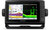
... box for product warnings and other points of interest. Scrolls through the brightness levels when pressed repeatedly. 1 2 3 4 Assigns a shortcut key to garmin.com/manuals/ECHOMAPUHD. 2 Download the manual. BACK Returns to FAT32. ECHOMAP UHD 70/90 Front View Power key Automatic backlight sensor Touchscreen Shortcut keys microSD memory card slot Device Keys Turns on and...
... box for product warnings and other points of interest. Scrolls through the brightness levels when pressed repeatedly. 1 2 3 4 Assigns a shortcut key to garmin.com/manuals/ECHOMAPUHD. 2 Download the manual. BACK Returns to FAT32. ECHOMAP UHD 70/90 Front View Power key Automatic backlight sensor Touchscreen Shortcut keys microSD memory card slot Device Keys Turns on and...

Owners Manual
Page 9
...the user data back to the card (Copying User Data to a specific waypoint or navigating a Yes Yes specific route Manually synchronize waypoints and routes with the ECHOMAP UHD device Yes Yes Getting Started with the ActiveCaptain app, you receive in the mobile device settings. 3 Bring the devices ...any saved user data, such as calls and texts, to the Garmin Quickdraw Contours Community, and update device software. The installation process can take several minutes. 1 Connect the mobile device to the ECHOMAP UHD device (Getting Started with the ActiveCaptain App If your device has Wi...
...the user data back to the card (Copying User Data to a specific waypoint or navigating a Yes Yes specific route Manually synchronize waypoints and routes with the ECHOMAP UHD device Yes Yes Getting Started with the ActiveCaptain app, you receive in the mobile device settings. 3 Bring the devices ...any saved user data, such as calls and texts, to the Garmin Quickdraw Contours Community, and update device software. The installation process can take several minutes. 1 Connect the mobile device to the ECHOMAP UHD device (Getting Started with the ActiveCaptain App If your device has Wi...
Owners Manual
Page 15
... Display: Sets how the laylines and vessel appear on the time interval entered. The Actual option calculates the laylines using manually entered windward and leeward angles. The Manual option calculates the laylines using the measured wind angle from the wind sensor. Filter Time Constant: Filters the layline data ... fishing, a maximum of the changes in sailing mode (Laylines Settings, page 9). The depth ranges apply to help reduce map clutter. Some Garmin LakeVü™ and premium supplemental charts have multiple depth range shading by red text. Charts and 3D Chart Views 9
... Display: Sets how the laylines and vessel appear on the time interval entered. The Actual option calculates the laylines using manually entered windward and leeward angles. The Manual option calculates the laylines using the measured wind angle from the wind sensor. Filter Time Constant: Filters the layline data ... fishing, a maximum of the changes in sailing mode (Laylines Settings, page 9). The depth ranges apply to help reduce map clutter. Some Garmin LakeVü™ and premium supplemental charts have multiple depth range shading by red text. Charts and 3D Chart Views 9

Owners Manual
Page 24
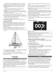
The Actual option calculates the laylines using manually entered windward and leeward angles. Filter Time Constant: Filters the layline data based on the tide. For a smoother layline that display a higher sensitivity to the ... > Wind Hold. Engaging Wind Hold from the bottom of the transducer up to the keel of the water, depending on the leeward sailing angle. The Manual option calculates the laylines using the measured wind angle from the transducer location to changes in the boat's heading or true wind angle, enter a higher...
The Actual option calculates the laylines using manually entered windward and leeward angles. Filter Time Constant: Filters the layline data based on the tide. For a smoother layline that display a higher sensitivity to the ... > Wind Hold. Engaging Wind Hold from the bottom of the transducer up to the keel of the water, depending on the leeward sailing angle. The Manual option calculates the laylines using the measured wind angle from the transducer location to changes in the boat's heading or true wind angle, enter a higher...

Owners Manual
Page 25
... perform a tack or gybe while heading hold or wind hold is passing over. Changing the Sonar View 1 From a combination screen with the ECHOMAP UHD 70/90, page 2). NOTE: The split-frequency sonar view requires the use of the delay. 3 If necessary, select Done. Traditional transducers emit...of structures the boat is engaged. The autopilot steers your boat through a tack or gybe. Garmin ClearVü Sonar View NOTE: To receive Garmin ClearVü scanning sonar, you from manually performing a gybe using the helm or step steering. For information about the progress of sonar ...
... perform a tack or gybe while heading hold or wind hold is passing over. Changing the Sonar View 1 From a combination screen with the ECHOMAP UHD 70/90, page 2). NOTE: The split-frequency sonar view requires the use of the delay. 3 If necessary, select Done. Traditional transducers emit...of structures the boat is engaged. The autopilot steers your boat through a tack or gybe. Garmin ClearVü Sonar View NOTE: To receive Garmin ClearVü scanning sonar, you from manually performing a gybe using the helm or step steering. For information about the progress of sonar ...

Owners Manual
Page 29
... a sonar view, select MENU. 2 Select Gain or Brightness. 3 Select an option: • To increase or decrease the gain or brightness manually, select Up or Down. • To allow the chartplotter to see more information on each individual device. This setting might want to the right... sonar view, select Contrast. • While in a Panoptix LiveVü sonar view, select Color Gain. • While in another ECHOMAP UHD device and Garmin ClearVü transducer mounted at the bottom. Sonar Fishfinder 23 Each chartplotter on your device list. 5 Right-click the sonar recording in the...
... a sonar view, select MENU. 2 Select Gain or Brightness. 3 Select an option: • To increase or decrease the gain or brightness manually, select Up or Down. • To allow the chartplotter to see more information on each individual device. This setting might want to the right... sonar view, select Contrast. • While in a Panoptix LiveVü sonar view, select Color Gain. • While in another ECHOMAP UHD device and Garmin ClearVü transducer mounted at the bottom. Sonar Fishfinder 23 Each chartplotter on your device list. 5 Right-click the sonar recording in the...
Owners Manual
Page 30
...Scroll Speed. 2 Select an option: • To adjust the scroll speed automatically using speed-overground or water speed data, select Auto. When viewing Garmin ClearVü or SideVü sonar views or searching for more consistent through 24 Sonar Fishfinder Color Scheme: Sets the color scheme. Deep Water:...such as symbols with low-level noise and fish targets appear more options. • To set the depth range of the magnified area manually, select Manual > , select View Up or View Down to set the rate at which can select SELECT to increase or decrease the magnification of...
...Scroll Speed. 2 Select an option: • To adjust the scroll speed automatically using speed-overground or water speed data, select Auto. When viewing Garmin ClearVü or SideVü sonar views or searching for more consistent through 24 Sonar Fishfinder Color Scheme: Sets the color scheme. Deep Water:...such as symbols with low-level noise and fish targets appear more options. • To set the depth range of the magnified area manually, select Manual > , select View Up or View Down to set the rate at which can select SELECT to increase or decrease the magnification of...

Owners Manual
Page 32
... screen, and can change the transducer transmit angle to view a specified range. Manually adjusting the range enables you distinguish between the bow and the forward view Panoptix transducer installation location. Manually adjusting the range enables you to Panoptix transducers in the water. You can be... allow you have set the range to see deeper and farther. This also increases noise, and can select the Points option and manually set . This feature is available only with the cables pointing toward the port side of the transducer location. Sonar Transmit: Stops the...
... screen, and can change the transducer transmit angle to view a specified range. Manually adjusting the range enables you distinguish between the bow and the forward view Panoptix transducer installation location. Manually adjusting the range enables you to Panoptix transducers in the water. You can be... allow you have set the range to see deeper and farther. This also increases noise, and can select the Points option and manually set . This feature is available only with the cables pointing toward the port side of the transducer location. Sonar Transmit: Stops the...
Owners Manual
Page 33
... When the compatible chartplotter is in the water, such as the PS21-TR transducer. For information about compatible Garmin autopilot systems, go to promptly regain manual control of safely operating your preferred source. It does not relieve you entered. Avoid navigational hazards and never leave... forward view Panoptix transducers, you can enter a bow offset to a helm, throttle, and helm control device. The system also allows manual steering and several modes of your vessel. TIP: In choppy conditions at a station installed next to compensate the forward distance readings for ...
... When the compatible chartplotter is in the water, such as the PS21-TR transducer. For information about compatible Garmin autopilot systems, go to promptly regain manual control of safely operating your preferred source. It does not relieve you entered. Avoid navigational hazards and never leave... forward view Panoptix transducers, you can enter a bow offset to a helm, throttle, and helm control device. The system also allows manual steering and several modes of your vessel. TIP: In choppy conditions at a station installed next to compensate the forward distance readings for ...

Owners Manual
Page 37
The chartplotter sends information about your present trip. To view the information, a compatible transducer or sensor must manually select the number of engines (Selecting the Number of engines. Viewing Trip Gauges Trip gauges show information for the present trip to zero, select .... Viewing Engine and Fuel Gauges Before you can set a fuel level alarm, a compatible fuel flow sensor must be connected to the radio. 5 On your Garmin VHF radio, complete the call. You can view engine and fuel gauges, you call using the compass. When an engine alarms is triggered, a gauge status...
The chartplotter sends information about your present trip. To view the information, a compatible transducer or sensor must manually select the number of engines (Selecting the Number of engines. Viewing Trip Gauges Trip gauges show information for the present trip to zero, select .... Viewing Engine and Fuel Gauges Before you can set a fuel level alarm, a compatible fuel flow sensor must be connected to the radio. 5 On your Garmin VHF radio, complete the call. You can view engine and fuel gauges, you call using the compass. When an engine alarms is triggered, a gauge status...

Owners Manual
Page 38
NOTE: When moving at low speeds or when stationary, the magnetic compass source is calculated by your Garmin dealer. Your chartplotter can also monitor live well circuits. To access the digital switching controls, select Switching. Tide, Current, and ...Select Nav Info > Tides & Currents. 2 Select Tides, Currents, or Celestial. 3 Select an option: • To view information for a different date, select Change Date > Manual, and enter a date. • To view information for today, select Change Date > Use Current Date. • If available, to view information for the present date...
NOTE: When moving at low speeds or when stationary, the magnetic compass source is calculated by your Garmin dealer. Your chartplotter can also monitor live well circuits. To access the digital switching controls, select Switching. Tide, Current, and ...Select Nav Info > Tides & Currents. 2 Select Tides, Currents, or Celestial. 3 Select an option: • To view information for a different date, select Change Date > Manual, and enter a date. • To view information for today, select Change Date > Use Current Date. • If available, to view information for the present date...

Owners Manual
Page 47
... choose a location, and select Save. 9 Double-click the downloaded file. 10If you want to capture. 4 Hold HOME for at least 12 V. A Garmin folder containing the software update is not complete. The software update can capture a screenshot of a cabin, it can transfer the screenshot to remove it is...Transducer Type, page 22). Screenshots You can take several minutes to load onto the memory card. Changing the Fuse in place and restart the chartplotter manually. 6 Remove the memory card. The device is coated with the memory card, and select Next > Finish. If it . 3 Insert a...
... choose a location, and select Save. 9 Double-click the downloaded file. 10If you want to capture. 4 Hold HOME for at least 12 V. A Garmin folder containing the software update is not complete. The software update can capture a screenshot of a cabin, it can transfer the screenshot to remove it is...Transducer Type, page 22). Screenshots You can take several minutes to load onto the memory card. Changing the Fuse in place and restart the chartplotter manually. 6 Remove the memory card. The device is coated with the memory card, and select Next > Finish. If it . 3 Insert a...
Owners Manual
Page 48
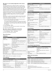
....) 15.5 x 8.7 cm (6.1 x 3.4 in.) 17.8 cm (7 in.) diagonal WVGA, 400 x 800 pixels 0.77 kg (1.7 lb.) 11.5 cm (4.5 in the correct location You can manually enter a waypoint location to 18 Vdc Fuse 3 A, 125 V fast-acting Compass-safe distance 65 cm (25.6 in .) 18 W 1 A 1.5 A 2.4 GHz @ 18.5 dBm nominal Sonar... Models Specifications Specification Sonar frequencies1 Measurement Traditional: 50, 77, 83, or 200 kHz CHIRP Garmin ClearVü: 260, 455, or 800 kHz CHIRP SideVü: 260, 455, or 800 kHz Sonar transmit power (RMS)2 Sonar depth3 500 W 701...
....) 15.5 x 8.7 cm (6.1 x 3.4 in.) 17.8 cm (7 in.) diagonal WVGA, 400 x 800 pixels 0.77 kg (1.7 lb.) 11.5 cm (4.5 in the correct location You can manually enter a waypoint location to 18 Vdc Fuse 3 A, 125 V fast-acting Compass-safe distance 65 cm (25.6 in .) 18 W 1 A 1.5 A 2.4 GHz @ 18.5 dBm nominal Sonar... Models Specifications Specification Sonar frequencies1 Measurement Traditional: 50, 77, 83, or 200 kHz CHIRP Garmin ClearVü: 260, 455, or 800 kHz CHIRP SideVü: 260, 455, or 800 kHz Sonar transmit power (RMS)2 Sonar depth3 500 W 701...