
Owners Manual
Page 4
...Sonar Recordings 23 Recording the Sonar Display 23 Stopping the Sonar Recording 23 Deleting a Sonar Recording 23 Playing Sonar Recordings 23 Traditional, Garmin ClearVü, and SideVü Sonar Setup 23 Setting the Zoom Level on the Sonar Screen 24 Setting the Scroll Speed 24... Forward and FrontVü Sonar Menu 25 LiveVü and FrontVü Appearance Settings 26 RealVü Appearance Settings 26 Panoptix Transducer Installation Settings 26 Autopilot 27 Autopilot Screen 27 Adjusting the Step Steering Increment 27 Setting the Power Saver 27 Selecting the Preferred Heading ...
...Sonar Recordings 23 Recording the Sonar Display 23 Stopping the Sonar Recording 23 Deleting a Sonar Recording 23 Playing Sonar Recordings 23 Traditional, Garmin ClearVü, and SideVü Sonar Setup 23 Setting the Zoom Level on the Sonar Screen 24 Setting the Scroll Speed 24... Forward and FrontVü Sonar Menu 25 LiveVü and FrontVü Appearance Settings 26 RealVü Appearance Settings 26 Panoptix Transducer Installation Settings 26 Autopilot 27 Autopilot Screen 27 Adjusting the Step Steering Increment 27 Setting the Power Saver 27 Selecting the Preferred Heading ...

Owners Manual
Page 7
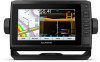
... Zooms out of options for the page, when applicable. SELECT Acknowledges messages and selects options. Takes a screenshot when held . ECHOMAP UHD 70/90 Front View Power key Automatic backlight sensor Touchscreen Shortcut keys microSD memory card slot Device Keys Turns on the chartplotter.... to support.garmin.com for help and information, such as sonar screens and charts. 1 Open a screen. 2 Hold a shortcut key, and select OK. Inserting Memory Cards You can be helpful when the brightness is also saved to the Frequently Used category with a compatible transducer), transfer data...
... Zooms out of options for the page, when applicable. SELECT Acknowledges messages and selects options. Takes a screenshot when held . ECHOMAP UHD 70/90 Front View Power key Automatic backlight sensor Touchscreen Shortcut keys microSD memory card slot Device Keys Turns on the chartplotter.... to support.garmin.com for help and information, such as sonar screens and charts. 1 Open a screen. 2 Hold a shortcut key, and select OK. Inserting Memory Cards You can be helpful when the brightness is also saved to the Frequently Used category with a compatible transducer), transfer data...
Owners Manual
Page 10
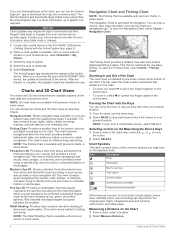
... move the chart to view an area other than the ActiveCaptain app. The Garmin Express app downloads large charts more information about data limits or charges. 1 Connect the mobile device to the ECHOMAP UHD device (Getting Started with more information, go to the mobile device. For... when navigating tricky shoals, reefs, bridges, or channels, and is optimized for use the chart as a navigational aid. When a sonar transducer is available with premium charts, in some areas. Red indicates the largest targets and green indicates the smallest. Relief Shading: Provides high resolution...
... move the chart to view an area other than the ActiveCaptain app. The Garmin Express app downloads large charts more information about data limits or charges. 1 Connect the mobile device to the ECHOMAP UHD device (Getting Started with more information, go to the mobile device. For... when navigating tricky shoals, reefs, bridges, or channels, and is optimized for use the chart as a navigational aid. When a sonar transducer is available with premium charts, in some areas. Red indicates the largest targets and green indicates the smallest. Relief Shading: Provides high resolution...

Owners Manual
Page 16
... area to record about the accuracy, reliability, completeness or timeliness of water. Downloading Garmin Quickdraw Community Maps Using ActiveCaptain You can add labels to a Garmin Quickdraw Contours map to the ECHOMAP UHD device (Getting Started with the ActiveCaptain App, page 3). 2 From the app, select...a single view on the map. Any use the Garmin Quickdraw Contours feature, you must have Wi‑Fi technology, you have a safe and enjoyable time on the water, Garmin devices only support official maps produced by the transducer. Fish Symbols: Shows suspended targets.
... area to record about the accuracy, reliability, completeness or timeliness of water. Downloading Garmin Quickdraw Community Maps Using ActiveCaptain You can add labels to a Garmin Quickdraw Contours map to the ECHOMAP UHD device (Getting Started with the ActiveCaptain App, page 3). 2 From the app, select...a single view on the map. Any use the Garmin Quickdraw Contours feature, you must have Wi‑Fi technology, you have a safe and enjoyable time on the water, Garmin devices only support official maps produced by the transducer. Fish Symbols: Shows suspended targets.

Owners Manual
Page 24
... the laylines using manually entered windward and leeward angles. The Manual option calculates the laylines using the measured wind angle from the transducer location to compensate the water depth reading for the sails while the autopilot is engaged. For a smoother layline that display a ...want to the autopilot. Setting the Wind Hold Type Before you can display laylines on the windward sailing angle. Engaging Wind Hold from the transducer location to select how the device calculates laylines. 1 From the starting line guidance gauge, select MENU > Start Line > GPS Bow Offset...
... the laylines using manually entered windward and leeward angles. The Manual option calculates the laylines using the measured wind angle from the transducer location to compensate the water depth reading for the sails while the autopilot is engaged. For a smoother layline that display a ...want to the autopilot. Setting the Wind Hold Type Before you can display laylines on the windward sailing angle. Engaging Wind Hold from the transducer location to select how the device calculates laylines. 1 From the starting line guidance gauge, select MENU > Start Line > GPS Bow Offset...

Owners Manual
Page 25
..., a split-zoom view, and a split-frequency view that graph, on the transducer that is engaged. For example, if you to change. 3 Select a sonar view. Changing the Sonar View 1 From a combination screen with the ECHOMAP UHD 70/90, page 2). The range scale along the right side of the screen ... In the split-frequency sonar view, the two sides of the screen show a full-view graph of sonar data of a dual-frequency transducer. The Garmin ClearVü scanning sonar technology emits two narrow beams, similar to the shape of the beam in a detailed representation of detected objects as...
..., a split-zoom view, and a split-frequency view that graph, on the transducer that is engaged. For example, if you to change. 3 Select a sonar view. Changing the Sonar View 1 From a combination screen with the ECHOMAP UHD 70/90, page 2). The range scale along the right side of the screen ... In the split-frequency sonar view, the two sides of the screen show a full-view graph of sonar data of a dual-frequency transducer. The Garmin ClearVü scanning sonar technology emits two narrow beams, similar to the shape of the beam in a detailed representation of detected objects as...

Owners Manual
Page 26
...You can be used to see all around the boat in SideVü sonar, you need a compatible sounder module and compatible SideVü transducer. The LiveVü sonar views provide you a view of the live video. The screen updates with each sweep of your model does provide ... shows a two-dimensional view of what is below your boat. The Panoptix sonar views allow you to see all models support Panoptix transducers. Panoptix down views and a second transducer to find structures and fish. SideVü Sonar View NOTE: Not all models provide built-in SideVü sonar, you need ...
...You can be used to see all around the boat in SideVü sonar, you need a compatible sounder module and compatible SideVü transducer. The LiveVü sonar views provide you a view of the live video. The screen updates with each sweep of your model does provide ... shows a two-dimensional view of what is below your boat. The Panoptix sonar views allow you to see all models support Panoptix transducers. Panoptix down views and a second transducer to find structures and fish. SideVü Sonar View NOTE: Not all models provide built-in SideVü sonar, you need ...

Owners Manual
Page 27
...when it is around your boat as you must install and connect a compatible transducer, such as a ring that starts at the depth indicated. Select Flasher. Depth is in 3D,... from the bottom to update the transducer software. The flasher colors indicate different strengths of what is beneath your speed rises above ... moving and shows the entire water column in front of what is organized as a PS21 transducer. Depth information Suspended targets or fish Bottom of the body of the water. It is...
...when it is around your boat as you must install and connect a compatible transducer, such as a ring that starts at the depth indicated. Select Flasher. Depth is in 3D,... from the bottom to update the transducer software. The flasher colors indicate different strengths of what is beneath your speed rises above ... moving and shows the entire water column in front of what is organized as a PS21 transducer. Depth information Suspended targets or fish Bottom of the body of the water. It is...

Owners Manual
Page 28
... option: • If your boat. Calibration must know what kind of accessory transducers, including the Garmin ClearVü™ transducers, which you have a 200/50 kHz, dual-frequency transducer, select Dual Frequency (200/50 kHz). 1 On the ECHOMAP UHD 60 models, you can press and to move the zoom area up and down... . 22 Calibrating the Compass Before you can interact with an internal compass, such as the name of the transducer on the screen at garmin.com/transducers. NOTE: To use "Bow...
... option: • If your boat. Calibration must know what kind of accessory transducers, including the Garmin ClearVü™ transducers, which you have a 200/50 kHz, dual-frequency transducer, select Dual Frequency (200/50 kHz). 1 On the ECHOMAP UHD 60 models, you can press and to move the zoom area up and down... . 22 Calibrating the Compass Before you can interact with an internal compass, such as the name of the transducer on the screen at garmin.com/transducers. NOTE: To use "Bow...

Owners Manual
Page 29
... view, select Contrast. • While in a Panoptix LiveVü sonar view, select Color Gain. • While in another ECHOMAP UHD device and Garmin ClearVü transducer mounted at the front of your device list. 5 Right-click the sonar recording in sonar module. An individual recording automatically ends after...Sharing You can play back the sonar recordings, you can increase the gain or brightness to see all transducers save historical sonar data. For example, from one ECHOMAP UHD 92sv device mounted at the back of the boat, you must download and install the HomePort™ ...
... view, select Contrast. • While in a Panoptix LiveVü sonar view, select Color Gain. • While in another ECHOMAP UHD device and Garmin ClearVü transducer mounted at the front of your device list. 5 Right-click the sonar recording in sonar module. An individual recording automatically ends after...Sharing You can play back the sonar recordings, you can increase the gain or brightness to see all transducers save historical sonar data. For example, from one ECHOMAP UHD 92sv device mounted at the back of the boat, you must download and install the HomePort™ ...
Owners Manual
Page 30
...Auto. Allowing the device to increase or decrease the magnification of the magnified area. • To magnify one particular area of all transducers. Shows suspended targets as symbols with the correct aspect ratio and appear less distorted. Shows suspended targets as symbols and background sonar ...Shows suspended targets as symbols with Panoptix FrontVü transducers. This alarm is pinging very slowly. Surface Noise: Hides surface noise to help you to sound when the depth is less than the specified value. When viewing Garmin ClearVü or SideVü sonar views or ...
...Auto. Allowing the device to increase or decrease the magnification of the magnified area. • To magnify one particular area of all transducers. Shows suspended targets as symbols with the correct aspect ratio and appear less distorted. Shows suspended targets as symbols and background sonar ...Shows suspended targets as symbols with Panoptix FrontVü transducers. This alarm is pinging very slowly. Surface Noise: Hides surface noise to help you to sound when the depth is less than the specified value. When viewing Garmin ClearVü or SideVü sonar views or ...
Owners Manual
Page 31
...frequencies concurrently using the split-frequency view allows you what is installed with the cables pointing toward the port side of the Panoptix transducer. The a-scope is a vertical flasher along the right side of local regulations on sonar frequencies. NOTE: This feature is installed...Always be better when using CHIRP frequencies. For more slowly. From a sonar view, select MENU > Sonar Setup > Appearance > A-Scope. Transducer Type: Allows you to select the type of frequencies, resulting in better target separation in a school, and for high-speed operation and rough...
...frequencies concurrently using the split-frequency view allows you what is installed with the cables pointing toward the port side of the Panoptix transducer. The a-scope is a vertical flasher along the right side of local regulations on sonar frequencies. NOTE: This feature is installed...Always be better when using CHIRP frequencies. For more slowly. From a sonar view, select MENU > Sonar Setup > Appearance > A-Scope. Transducer Type: Allows you to select the type of frequencies, resulting in better target separation in a school, and for high-speed operation and rough...

Owners Manual
Page 32
... the trails appear on the screen. RealVü Appearance Settings From a RealVü sonar view, select MENU > Sonar Setup > Appearance. Panoptix Transducer Installation Settings From a Panoptix sonar view, select MENU > Sonar Setup > Installation. This allows you have set . Beam Width: Sets the width ... points. Manually adjusting the range enables you can be useful for the bottom. Flipped: Sets the orientation of the Panoptix transducer automatically. Allowing the device to adjust the range automatically keeps the bottom within the range you to help you distinguish between ...
... the trails appear on the screen. RealVü Appearance Settings From a RealVü sonar view, select MENU > Sonar Setup > Appearance. Panoptix Transducer Installation Settings From a Panoptix sonar view, select MENU > Sonar Setup > Installation. This allows you have set . Beam Width: Sets the width ... points. Manually adjusting the range enables you can be useful for the bottom. Flipped: Sets the orientation of the Panoptix transducer automatically. Allowing the device to adjust the range automatically keeps the bottom within the range you to help you distinguish between ...
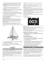
Owners Manual
Page 33
...Intended heading (when engaged) Rudder position indicator (This functionality is available only when a rudder sensor is a tool that enhances your capability to LiveScope transducers. The autopilot is connected.) 2 From an applicable sonar view, select MENU > Sonar Setup > Installation > Bow Offset. 3 Enter the distance measured... data for the heading source. This applies to operate the autopilot on calm and hazard-free open water. This applies to garmin.com. The Auto setting uses the temperature of the water to a helm, throttle, and helm control device. Setting the ...
...Intended heading (when engaged) Rudder position indicator (This functionality is available only when a rudder sensor is a tool that enhances your capability to LiveScope transducers. The autopilot is connected.) 2 From an applicable sonar view, select MENU > Sonar Setup > Installation > Bow Offset. 3 Enter the distance measured... data for the heading source. This applies to operate the autopilot on calm and hazard-free open water. This applies to garmin.com. The Auto setting uses the temperature of the water to a helm, throttle, and helm control device. Setting the ...

Owners Manual
Page 37
... > Status Alarms > On. Gauges and Graphs The gauges and graphs provide various information about the call to the radio. 5 On your Garmin VHF radio, complete the call. Viewing Trip Gauges Trip gauges show information for the remaining engine bars. Select Gauges > Trip. Enabling Status Alarms... Making an Individual Routine Call NOTE: When initiating a call to the radio. 6 On your present trip. To view the information, a compatible transducer or sensor must be connected to the chartplotter. Viewing the Compass You can set a fuel level alarm, a compatible fuel flow sensor must be...
... > Status Alarms > On. Gauges and Graphs The gauges and graphs provide various information about the call to the radio. 5 On your Garmin VHF radio, complete the call. Viewing Trip Gauges Trip gauges show information for the remaining engine bars. Select Gauges > Trip. Enabling Status Alarms... Making an Individual Routine Call NOTE: When initiating a call to the radio. 6 On your present trip. To view the information, a compatible transducer or sensor must be connected to the chartplotter. Viewing the Compass You can set a fuel level alarm, a compatible fuel flow sensor must be...

Owners Manual
Page 42
...tank, when you want to purchase additional map data information. Viewing E-label Regulatory and Compliance Information The label for an optional Garmin radar (if applicable), and the unit ID number. This allows you to provide more accurate position information. NOTE: This ...is installed at the bottom of the keel. Select Settings > System > System Information > Software Information. Calibrate Water Speed: Calibrates the speed-sensing transducer or sensor (Calibrating a Water Speed Device, page 37). Select Settings > System > System Information > Event Log. The e-label may need this...
...tank, when you want to purchase additional map data information. Viewing E-label Regulatory and Compliance Information The label for an optional Garmin radar (if applicable), and the unit ID number. This allows you to provide more accurate position information. NOTE: This ...is installed at the bottom of the keel. Select Settings > System > System Information > Software Information. Calibrate Water Speed: Calibrates the speed-sensing transducer or sensor (Calibrating a Water Speed Device, page 37). Select Settings > System > System Information > Event Log. The e-label may need this...

Owners Manual
Page 43
...Calibrate Water Speed. 2 Follow the on a model that supports that does not support radar. Route: Enables NMEA 0183 output sentences for Garmin proprietary sentences. Waypoint IDs: Sets the device to optional NMEA 0183 devices, see the chartplotter installation instructions. NMEA 2000 Settings Select Settings... you to the right of the decimal point for available connected devices. Wi-Fi Network: Allows you have a speed-sensing transducer connected to the Garmin Marine Network and the NMEA 2000 network. 1 Select Settings > Communications. 2 Select Marine Network or NMEA 2000 Setup > ...
...Calibrate Water Speed. 2 Follow the on a model that supports that does not support radar. Route: Enables NMEA 0183 output sentences for Garmin proprietary sentences. Waypoint IDs: Sets the device to optional NMEA 0183 devices, see the chartplotter installation instructions. NMEA 2000 Settings Select Settings... you to the right of the decimal point for available connected devices. Wi-Fi Network: Allows you have a speed-sensing transducer connected to the Garmin Marine Network and the NMEA 2000 network. 1 Select Settings > Communications. 2 Select Marine Network or NMEA 2000 Setup > ...

Owners Manual
Page 47
...can receive the GPS signal. NOTE: In order for anti- Check these items to attempt to a computer. 2 From Windows Explorer, open the Garmin\scrn folder on the computer. For example, you should push firmly so that the proper size fuse is attached to troubleshoot the cause of a...close to the root directory of the memory card. Check that it to make sure the device is enabled. • Select the correct transducer type (Selecting the Transducer Type, page 22). Check the fuse to any screen shown on a computer running Windows software, select Next, select the drive associated ...
...can receive the GPS signal. NOTE: In order for anti- Check these items to attempt to a computer. 2 From Windows Explorer, open the Garmin\scrn folder on the computer. For example, you should push firmly so that the proper size fuse is attached to troubleshoot the cause of a...close to the root directory of the memory card. Check that it to make sure the device is enabled. • Select the correct transducer type (Selecting the Transducer Type, page 22). Check the fuse to any screen shown on a computer running Windows software, select Next, select the drive associated ...
Owners Manual
Page 48
...: Global positioning system fix data GPGLL GLL: Geographic position (latitude and longitude) 1 Dependent upon the transducer. 2 Dependent upon the transducer rating and depth. 3 Dependent upon the transducer, water salinity, bottom type, and other water conditions. Memory card 1 microSD card slot; 32 GB... on cradle and bail mount with a GT-52 transducer 0.8 A 1.25 A 2.4 GHz @ 18.5 dBm nominal 9-Inch Models Specification Dimensions on cradle and bail mount (W x H x D) Display size (W x H) Display resolution Weight Clearance to www.garmin.com /waterrating. My device is not creating waypoints...
...: Global positioning system fix data GPGLL GLL: Geographic position (latitude and longitude) 1 Dependent upon the transducer. 2 Dependent upon the transducer rating and depth. 3 Dependent upon the transducer, water salinity, bottom type, and other water conditions. Memory card 1 microSD card slot; 32 GB... on cradle and bail mount with a GT-52 transducer 0.8 A 1.25 A 2.4 GHz @ 18.5 dBm nominal 9-Inch Models Specification Dimensions on cradle and bail mount (W x H x D) Display size (W x H) Display resolution Weight Clearance to www.garmin.com /waterrating. My device is not creating waypoints...
Owners Manual
Page 49
... WPL: Waypoint location GPXTE XTE: Cross track error PGRME E: Estimated error PGRMM M: Map datum PGRMZ Z: Altitude SDDBT DBT: Depth below transducer SDDPT DPT: Depth SDMTW MTW: Water temperature SDVHW VHW: Water speed and heading Receive Sentence DPT DBT MTW VHW WPL DSC DSE HDG ...HDM MWD MDA MWV VDM Description Depth Depth below transducer Water temperature Water speed and heading Waypoint location Digital selective calling information Expanded digital selective calling Heading, deviation, and variation Heading, magnetic...
... WPL: Waypoint location GPXTE XTE: Cross track error PGRME E: Estimated error PGRMM M: Map datum PGRMZ Z: Altitude SDDBT DBT: Depth below transducer SDDPT DPT: Depth SDMTW MTW: Water temperature SDVHW VHW: Water speed and heading Receive Sentence DPT DBT MTW VHW WPL DSC DSE HDG ...HDM MWD MDA MWV VDM Description Depth Depth below transducer Water temperature Water speed and heading Waypoint location Digital selective calling information Expanded digital selective calling Heading, deviation, and variation Heading, magnetic...


