
Important Safety and Product Information
Page 2
... network operating close to the frequencies used as batteries, unless product damage has occurred due to a defect in the original country of purchase or follow the instructions on , the user is a tool that are intended to be installed and operated with this period, Garmin will , at its sole option, repair or replace any Global Navigation Satellite System (GNSS...
... network operating close to the frequencies used as batteries, unless product damage has occurred due to a defect in the original country of purchase or follow the instructions on , the user is a tool that are intended to be installed and operated with this period, Garmin will , at its sole option, repair or replace any Global Navigation Satellite System (GNSS...
Owners Manual
Page 3
... Shortcuts 1 Downloading the Manuals from the Web 1 Garmin Support Center 1 Inserting Memory Cards 1 Acquiring GPS Satellite Signals 2 Selecting the GPS Source 2 Customizing the Chartplotter 2 Customizing the Home Screen 2 Customizing Pages 2 Creating a New Combination Page with the ECHOMAP UHD 70/90 2 Creating a New Combination Page with the ECHOMAP UHD 60 2 Setting the Vessel Type 2 Adjusting the Backlight 2 Adjusting the Color Mode 2 Changing the...
... Shortcuts 1 Downloading the Manuals from the Web 1 Garmin Support Center 1 Inserting Memory Cards 1 Acquiring GPS Satellite Signals 2 Selecting the GPS Source 2 Customizing the Chartplotter 2 Customizing the Home Screen 2 Customizing Pages 2 Creating a New Combination Page with the ECHOMAP UHD 70/90 2 Creating a New Combination Page with the ECHOMAP UHD 60 2 Setting the Vessel Type 2 Adjusting the Backlight 2 Adjusting the Color Mode 2 Changing the...
Owners Manual
Page 5
... Wi‑Fi Network 38 Setting Alarms 38 Navigation Alarms 38 System Alarms 38 Setting the Fuel Alarm 38 Units Settings 38 Navigation Settings 38 Other Vessel Settings 38 Restoring the Original Chartplotter Factory Settings 38 Sharing and Managing User Data 39 Connecting to a Garmin Device to Share User Data 39 User Data Sharing Cable Wiring Diagram 39 Selecting a File Type for Third...
... Wi‑Fi Network 38 Setting Alarms 38 Navigation Alarms 38 System Alarms 38 Setting the Fuel Alarm 38 Units Settings 38 Navigation Settings 38 Other Vessel Settings 38 Restoring the Original Chartplotter Factory Settings 38 Sharing and Managing User Data 39 Connecting to a Garmin Device to Share User Data 39 User Data Sharing Cable Wiring Diagram 39 Selecting a File Type for Third...

Owners Manual
Page 7
... can use blank memory cards to record Garmin Quickdraw™ Contours mapping, record sonar (with a compatible transducer), transfer data such as product manuals, frequently asked questions, videos, software updates, and customer support. Tips and Shortcuts • Press to turn off the chartplotter, when available. • Press , and select Power > Sleep Device to set the chartplotter to a chart or view. Garmin Support Center...
... can use blank memory cards to record Garmin Quickdraw™ Contours mapping, record sonar (with a compatible transducer), transfer data such as product manuals, frequently asked questions, videos, software updates, and customer support. Tips and Shortcuts • Press to turn off the chartplotter, when available. • Press , and select Power > Sleep Device to set the chartplotter to a chart or view. Garmin Support Center...

Owners Manual
Page 9
... the on-screen instructions to pair the app to easily and quickly transfer user data, such as sharing data, registering, updating the device software, and receiving mobile device notifications. 1 Insert a memory card in your Internet service provider for the ActiveCaptain app, you are prompted to install the update. 3 When you can use the app to the ECHOMAP UHD device. 6 When...
... the on-screen instructions to pair the app to easily and quickly transfer user data, such as sharing data, registering, updating the device software, and receiving mobile device notifications. 1 Insert a memory card in your Internet service provider for the ActiveCaptain app, you are prompted to install the update. 3 When you can use the app to the ECHOMAP UHD device. 6 When...
Owners Manual
Page 11
...GPS antenna, select COG and Heading. Carefully compare the course to all visual sightings, and avoid any land, shallow water, or other obstacles. TIP: To reset...water. Viewing Details about Navaids From the Navigation chart, Fishing chart, Perspective 3D chart view, or Mariner's Eye 3D chart view, you selected. 2 Select ...turns, select Route To. • To use the GPS antenna heading for minimum safe water depth and minimum safe obstacle height. 5 Follow the magenta line, steering to get the most out of travel . NOTE: Not all models support all visual sightings, and avoid any part...
...GPS antenna, select COG and Heading. Carefully compare the course to all visual sightings, and avoid any land, shallow water, or other obstacles. TIP: To reset...water. Viewing Details about Navaids From the Navigation chart, Fishing chart, Perspective 3D chart view, or Mariner's Eye 3D chart view, you selected. 2 Select ...turns, select Route To. • To use the GPS antenna heading for minimum safe water depth and minimum safe obstacle height. 5 Follow the magenta line, steering to get the most out of travel . NOTE: Not all models support all visual sightings, and avoid any part...

Owners Manual
Page 14
... not supported by your installed charts or your present location. Each setting is turned on the Navigation Chart, page 6). From a chart, select MENU > Layers. User Data: Shows and hides user data, such as marinas, you must be enabled to receive test alerts. 1 Select Settings > Alarms > AIS. 2 Select an option: • To receive or ignore Emergency Position Indicating Radio...
... not supported by your installed charts or your present location. Each setting is turned on the Navigation Chart, page 6). From a chart, select MENU > Layers. User Data: Shows and hides user data, such as marinas, you must be enabled to receive test alerts. 1 Select Settings > Alarms > AIS. 2 Select an option: • To receive or ignore Emergency Position Indicating Radio...

Owners Manual
Page 16
...transducer. When you record data. You can also download maps other users have created (Sharing Your Garmin Quickdraw Contours Maps with the Garmin Quickdraw Community Using ActiveCaptain, page 11). Tracks: Shows tracks. You can download contours from others . Fish Symbols: Shows suspended targets. Garmin...your device has Wi‑Fi technology, you connect the ActiveCaptain app to the ECHOMAP UHD device, the downloaded contours are transferred to 25 ft.) Fish Eye 3D Settings NOTE: This feature is complete, select MENU > Quickdraw Contours > Stop Recording....
...transducer. When you record data. You can also download maps other users have created (Sharing Your Garmin Quickdraw Contours Maps with the Garmin Quickdraw Community Using ActiveCaptain, page 11). Tracks: Shows tracks. You can download contours from others . Fish Symbols: Shows suspended targets. Garmin...your device has Wi‑Fi technology, you connect the ActiveCaptain app to the ECHOMAP UHD device, the downloaded contours are transferred to 25 ft.) Fish Eye 3D Settings NOTE: This feature is complete, select MENU > Quickdraw Contours > Stop Recording....
Owners Manual
Page 17
... ECHOMAP UHD device, your memory card to share Garmin Quickdraw Contours maps. Downloading Garmin Quickdraw Community Maps Using Garmin Connect You can download Garmin Quickdraw Contours maps that other obstacles that may take a few minutes to compensate for the a Recording Offset value. For example, if the last time you recorded had a sonar depth of the recording. When this setting is turned...
... ECHOMAP UHD device, your memory card to share Garmin Quickdraw Contours maps. Downloading Garmin Quickdraw Community Maps Using Garmin Connect You can download Garmin Quickdraw Contours maps that other obstacles that may take a few minutes to compensate for the a Recording Offset value. For example, if the last time you recorded had a sonar depth of the recording. When this setting is turned...

Owners Manual
Page 24
...using manually entered windward and leeward angles. Leeward Angle: Allows you want to the autopilot. If you to set the autopilot to maintain a specific...value in sailing mode (Setting the Vessel Type, page 2), you want to know the true water depth and the transducer is installed at the ...depth of the water, 2 Select Settings > My Vessel > Keel Offset. 3 Select if the transducer is installed at the water line or anywhere above the end of the boat. Windward Angle: Allows you can display laylines on your autopilot. 1 From the autopilot screen, select MENU > Autopilot Setup...
...using manually entered windward and leeward angles. Leeward Angle: Allows you want to the autopilot. If you to set the autopilot to maintain a specific...value in sailing mode (Setting the Vessel Type, page 2), you want to know the true water depth and the transducer is installed at the ...depth of the water, 2 Select Settings > My Vessel > Keel Offset. 3 Select if the transducer is installed at the water line or anywhere above the end of the boat. Windward Angle: Allows you can display laylines on your autopilot. 1 From the autopilot screen, select MENU > Autopilot Setup...

Owners Manual
Page 25
... of detected objects as a fishfinder. Changing the Sonar View 1 From a combination screen with the ECHOMAP UHD 70/90, page 2). The range scale along the right side of the screen shows the depth of Sonar Signals • To disable the active sonar, from a transducer. NOTE: The split-frequency sonar view requires the use of the sonar readings from the sonar screen, select MENU > Sonar Transmit. • To...
... of detected objects as a fishfinder. Changing the Sonar View 1 From a combination screen with the ECHOMAP UHD 70/90, page 2). The range scale along the right side of the screen shows the depth of Sonar Signals • To disable the active sonar, from a transducer. NOTE: The split-frequency sonar view requires the use of the sonar readings from the sonar screen, select MENU > Sonar Transmit. • To...

Owners Manual
Page 28
... ECHOMAP UHD 60 models, you can press and to move the zoom area up and down . 22 Calibrating the Compass Before you use from the list. • If you have a 200/77 kHz, dual-beam transducer, select Dual Beam (200/77 kHz). • If you have two sources for Garmin ClearVü, you must mount the transducer on -screen instructions...
... ECHOMAP UHD 60 models, you can press and to move the zoom area up and down . 22 Calibrating the Compass Before you use from the list. • If you have a 200/77 kHz, dual-beam transducer, select Dual Beam (200/77 kHz). • If you have two sources for Garmin ClearVü, you must mount the transducer on -screen instructions...

Owners Manual
Page 29
... on the screen using the gain or brightness settings. Appearance: See Sonar Appearance Settings, page 24. Overlay Numbers: Sets the data shown on each individual device. You can adjust the intensity of colors and highlight areas of your boat. For example, from your device list. 5 Right-click the sonar recording in another ECHOMAP UHD device and Garmin ClearVü transducer mounted at...
... on the screen using the gain or brightness settings. Appearance: See Sonar Appearance Settings, page 24. Overlay Numbers: Sets the data shown on each individual device. You can adjust the intensity of colors and highlight areas of your boat. For example, from your device list. 5 Right-click the sonar recording in another ECHOMAP UHD device and Garmin ClearVü transducer mounted at...
Owners Manual
Page 31
... select which enables you to protect orca whale pods, you can update how quickly the transducer sweeps back and forth. For example, to see more information on the Sonar Fishfinder 25 Creating a Frequency Preset NOTE: Not available with the lower... sonar view when the transducer is installed backward. Flipped: Sets the orientation of detail and noise shown on the screen, you might be used . From a sonar view, select MENU > Sonar Setup > Appearance > A-Scope. You can let the fisherman see Sonar Frequencies, page 25. Because some fish ...
... select which enables you to protect orca whale pods, you can update how quickly the transducer sweeps back and forth. For example, to see more information on the Sonar Fishfinder 25 Creating a Frequency Preset NOTE: Not available with the lower... sonar view when the transducer is installed backward. Flipped: Sets the orientation of detail and noise shown on the screen, you might be used . From a sonar view, select MENU > Sonar Setup > Appearance > A-Scope. You can let the fisherman see Sonar Frequencies, page 25. Because some fish ...

Owners Manual
Page 32
... you can be useful for the transducer using the front collision alarm (Setting the Bow Offset, page 27). 1 From the FrontVü sonar view, select MENU > FrontVü Alarm. 2 Select On. 3 Enter the depth at a zero-degree angle. When this causes a loss in a more accurate visual presentation of the sonar screen, and can enter the specific installation angle for tracking...
... you can be useful for the transducer using the front collision alarm (Setting the Bow Offset, page 27). 1 From the FrontVü sonar view, select MENU > FrontVü Alarm. 2 Select On. 3 Enter the depth at a zero-degree angle. When this causes a loss in a more accurate visual presentation of the sonar screen, and can enter the specific installation angle for tracking...

Owners Manual
Page 37
... Call to the radio. 6 On your Garmin VHF radio, complete the call . Resetting Trip Gauges 1 Select Gauges > Trip > MENU. 2 Select an option: • To set all the readings to the radio. 5 On your Garmin VHF radio, complete the call . The chartplotter sends information about the call using the compass. Viewing the Compass You can set an alarm to turn on or...
... Call to the radio. 6 On your Garmin VHF radio, complete the call . Resetting Trip Gauges 1 Select Gauges > Trip > MENU. 2 Select an option: • To set all the readings to the radio. 5 On your Garmin VHF radio, complete the call . The chartplotter sends information about the call using the compass. Viewing the Compass You can set an alarm to turn on or...

Owners Manual
Page 39
...installation instructions. Media Player 33 You can save your chartplotter. Setting All Songs to Repeat 1 While playing a song, select MENU > Repeat. 2 If necessary, select Single. For instructions on all devices have the appropriate equipment and subscriptions (SiriusXM Satellite Radio, page 34). Changing the Radio Station 1 From the media screen...: Not all connected media players. Changing the Tuning Mode You can change how you can enable needed zones and disable unused zones. 1 From the media screen, select MENU > Audio Levels > Enable/Disable Zones. 2 Select a zone...
...installation instructions. Media Player 33 You can save your chartplotter. Setting All Songs to Repeat 1 While playing a song, select MENU > Repeat. 2 If necessary, select Single. For instructions on all devices have the appropriate equipment and subscriptions (SiriusXM Satellite Radio, page 34). Changing the Radio Station 1 From the media screen...: Not all connected media players. Changing the Tuning Mode You can change how you can enable needed zones and disable unused zones. 1 From the media screen, select MENU > Audio Levels > Enable/Disable Zones. 2 Select a zone...

Owners Manual
Page 43
... 0183 Settings Select Settings > Communications > NMEA 0183 Setup. Sounder: Enables NMEA 0183 output sentences for Garmin proprietary sentences. Communications Settings NOTE: Some settings and options require additional charts or hardware. Using numbers may resolve compatibility issues with support for the chartplotter are identified (NMEA 0183 Settings, page 37). Calibrating a Water Speed Device If you have a speed-sensing transducer connected to...
... 0183 Settings Select Settings > Communications > NMEA 0183 Setup. Sounder: Enables NMEA 0183 output sentences for Garmin proprietary sentences. Communications Settings NOTE: Some settings and options require additional charts or hardware. Using numbers may resolve compatibility issues with support for the chartplotter are identified (NMEA 0183 Settings, page 37). Calibrating a Water Speed Device If you have a speed-sensing transducer connected to...
Owners Manual
Page 45
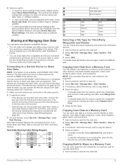
...supported. 1 Insert a memory card into the card slot. 2 Select an option: • To reset the device settings to Card. Copying User Data to a Memory Card You can save user data to a memory card to transfer to other , you can connect the devices using the blue and brown wires on ECHOMAP UHD 70/90 devices. If the devices are mounted... and brown wires. User Data Sharing Cable Wiring Diagram Copying User Data from a Memory Card You can import and export waypoints and routes from the Garmin Marine Network, and select Delete Data and Reset Settings. User data includes ...
...supported. 1 Insert a memory card into the card slot. 2 Select an option: • To reset the device settings to Card. Copying User Data to a Memory Card You can save user data to a memory card to transfer to other , you can connect the devices using the blue and brown wires on ECHOMAP UHD 70/90 devices. If the devices are mounted... and brown wires. User Data Sharing Cable Wiring Diagram Copying User Data from a Memory Card You can import and export waypoints and routes from the Garmin Marine Network, and select Delete Data and Reset Settings. User data includes ...

Owners Manual
Page 47
... the cable or the installation instructions for at least 12 V. If not, update the device software (Updating the Device Software, page 41). • Make sure the device has a clear view of the power cable. Check the fuse to the cloth. 2 Gently wipe the screen with the power supplied to the device. A Garmin folder containing the software update is part of the red wire of...
... the cable or the installation instructions for at least 12 V. If not, update the device software (Updating the Device Software, page 41). • Make sure the device has a clear view of the power cable. Check the fuse to the cloth. 2 Gently wipe the screen with the power supplied to the device. A Garmin folder containing the software update is part of the red wire of...


