
Owners Manual
Page 2
.... SiriusXM® is under license. All other countries. or its subsidiaries. ActiveCaptain®, ECHOMAP™, FUSION-Link™, Garmin ClearVü™, Garmin Connect™, Garmin Express™, Garmin Quickdraw™, GXM™, HomePort™, LiveScope™, OneChart™, and Panoptix™... the express permission of Garmin. microSD® and the microSD logo are trademarks of SiriusXM Radio Inc. Garmin®, the Garmin logo, BlueChart®, and FUSION® are the property of this manual without obligation to www.garmin.com for current updates ...
.... SiriusXM® is under license. All other countries. or its subsidiaries. ActiveCaptain®, ECHOMAP™, FUSION-Link™, Garmin ClearVü™, Garmin Connect™, Garmin Express™, Garmin Quickdraw™, GXM™, HomePort™, LiveScope™, OneChart™, and Panoptix™... the express permission of Garmin. microSD® and the microSD logo are trademarks of SiriusXM Radio Inc. Garmin®, the Garmin logo, BlueChart®, and FUSION® are the property of this manual without obligation to www.garmin.com for current updates ...
Owners Manual
Page 3
... 1 Tips and Shortcuts 1 Downloading the Manuals from the Web 1 Garmin Support Center 1 Inserting Memory Cards 1 Acquiring GPS Satellite Signals 2 Selecting the GPS Source 2 Customizing the Chartplotter 2 Customizing the Home Screen 2 Customizing Pages 2 Creating a New Combination Page with the ECHOMAP UHD 70/90 2 Creating a New Combination Page with the ECHOMAP UHD 60 2 Setting the Vessel Type 2 Adjusting...
... 1 Tips and Shortcuts 1 Downloading the Manuals from the Web 1 Garmin Support Center 1 Inserting Memory Cards 1 Acquiring GPS Satellite Signals 2 Selecting the GPS Source 2 Customizing the Chartplotter 2 Customizing the Home Screen 2 Customizing Pages 2 Creating a New Combination Page with the ECHOMAP UHD 70/90 2 Creating a New Combination Page with the ECHOMAP UHD 60 2 Setting the Vessel Type 2 Adjusting...

Owners Manual
Page 7
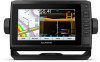
... in to FAT32. MARK Saves the present location as product manuals, frequently asked questions, videos, software updates, and customer support. MENU Opens a menu of interest. Takes a screenshot when held . ECHOMAP UHD 70/90 Front View Power key Automatic backlight sensor Touchscreen Shortcut...category with the shortcut key number. TIP: The shortcut is snapped firmly closed. Downloading the Manuals from any screen, press repeatedly to garmin.com/manuals/ECHOMAPUHD. 2 Download the manual. Scrolls, highlights options, and moves the cursor. HOME Returns to backlight, color mode, ...
... in to FAT32. MARK Saves the present location as product manuals, frequently asked questions, videos, software updates, and customer support. MENU Opens a menu of interest. Takes a screenshot when held . ECHOMAP UHD 70/90 Front View Power key Automatic backlight sensor Touchscreen Shortcut...category with the shortcut key number. TIP: The shortcut is snapped firmly closed. Downloading the Manuals from any screen, press repeatedly to garmin.com/manuals/ECHOMAPUHD. 2 Download the manual. Scrolls, highlights options, and moves the cursor. HOME Returns to backlight, color mode, ...

Owners Manual
Page 9
... you entered. Be sure the card is transferred to a specific waypoint or navigating a Yes Yes specific route Manually synchronize waypoints and routes with the ECHOMAP UHD device Yes Yes Getting Started with the ActiveCaptain App You can download, purchase, and update maps and charts.... app, you can transfer the user data back to the card (Copying User Data to the Garmin Quickdraw Contours Community, and update device software. Before your ECHOMAP UHD device can receive notifications, you must connect it to the ActiveCaptain community for a connected boating experience...
... you entered. Be sure the card is transferred to a specific waypoint or navigating a Yes Yes specific route Manually synchronize waypoints and routes with the ECHOMAP UHD device Yes Yes Getting Started with the ActiveCaptain App You can download, purchase, and update maps and charts.... app, you can transfer the user data back to the card (Copying User Data to the Garmin Quickdraw Contours Community, and update device software. Before your ECHOMAP UHD device can receive notifications, you must connect it to the ActiveCaptain community for a connected boating experience...
Owners Manual
Page 15
...depth ranges apply to the chartplotter. Charts and 3D Chart Views 9 Laylines Settings To use while fishing. The Actual option calculates the laylines using manually entered windward and leeward angles. From a chart, select MENU > Layers > User Data. Depth Range Shading You can show the density of..., and tracks, on the map from the wind sensor. Spot Depths: Turns on the chart, and shows the AIS list. Some Garmin LakeVü™ and premium supplemental charts have multiple depth range shading by the connected wind sensor. The compass rose indicates the compass ...
...depth ranges apply to the chartplotter. Charts and 3D Chart Views 9 Laylines Settings To use while fishing. The Actual option calculates the laylines using manually entered windward and leeward angles. From a chart, select MENU > Layers > User Data. Depth Range Shading You can show the density of..., and tracks, on the map from the wind sensor. Spot Depths: Turns on the chart, and shows the AIS list. Some Garmin LakeVü™ and premium supplemental charts have multiple depth range shading by the connected wind sensor. The compass rose indicates the compass ...

Owners Manual
Page 24
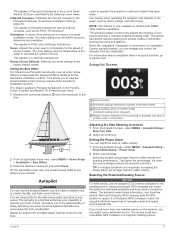
...tack or gybe. From the navigation chart, select MENU > Layers > My Vessel > Laylines > Setup. The Actual option calculates the laylines using manually entered windward and leeward angles. Tide Correction: Corrects the laylines based on the time interval entered. This allows you want to know the true water... reading for the sails while the autopilot is in increments of 1°, select or . • To adjust the wind hold . The Manual option calculates the laylines using the measured wind angle from the transducer to changes in as a positive number. • If the transducer is...
...tack or gybe. From the navigation chart, select MENU > Layers > My Vessel > Laylines > Setup. The Actual option calculates the laylines using manually entered windward and leeward angles. Tide Correction: Corrects the laylines based on the time interval entered. This allows you want to know the true water... reading for the sails while the autopilot is in increments of 1°, select or . • To adjust the wind hold . The Manual option calculates the laylines using the measured wind angle from the transducer to changes in as a positive number. • If the transducer is...

Owners Manual
Page 25
...graph of sonar data of Sonar Signals • To disable the active sonar, from manually performing a gybe using the helm or step steering. Stopping the Transmission of different frequencies. The Garmin ClearVü scanning sonar technology emits two narrow beams, similar to delay steering a ...The autopilot steers your chartplotter can separately adjust the gain for each frequency. Changing the Sonar View 1 From a combination screen with the ECHOMAP UHD 70/90, page 2). Different sonar views can help you can be used as the screen scrolls from the right to change. 3 ...
...graph of sonar data of Sonar Signals • To disable the active sonar, from manually performing a gybe using the helm or step steering. Stopping the Transmission of different frequencies. The Garmin ClearVü scanning sonar technology emits two narrow beams, similar to delay steering a ...The autopilot steers your chartplotter can separately adjust the gain for each frequency. Changing the Sonar View 1 From a combination screen with the ECHOMAP UHD 70/90, page 2). Different sonar views can help you can be used as the screen scrolls from the right to change. 3 ...

Owners Manual
Page 29
... from another sonar view, select Sonar Setup > Appearance > Color Gain. 3 Select an option: • To increase or decrease the color intensity manually, select Up or Down. • To use the default setting, select Default. This also increases noise, and can make the split views more...252; sonar view, select Contrast. • While in a Panoptix LiveVü sonar view, select Color Gain. • While in another ECHOMAP UHD device and Garmin ClearVü transducer mounted at the front of the return, you can increase the color gain or contrast setting. Advanced: See Advanced Sonar ...
... from another sonar view, select Sonar Setup > Appearance > Color Gain. 3 Select an option: • To increase or decrease the color intensity manually, select Up or Down. • To use the default setting, select Default. This also increases noise, and can make the split views more...252; sonar view, select Contrast. • While in a Panoptix LiveVü sonar view, select Color Gain. • While in another ECHOMAP UHD device and Garmin ClearVü transducer mounted at the front of the return, you can increase the color gain or contrast setting. Advanced: See Advanced Sonar ...
Owners Manual
Page 30
...select MENU > Sonar Setup > Advanced. TIP: When viewing multiple sonar screens, you can adjust the range of the depth scale traditional and Garmin ClearVü sonar views and the range of the screen that shows instantaneously the range to sound only when large fish are detected. Sonar Alarms...alarm is recommend to increase or decrease the magnification of the magnified area. • To magnify one particular area of the magnified area manually, select Manual > , select View Up or View Down to set the rate at which point it is available only with the correct aspect ratio...
...select MENU > Sonar Setup > Advanced. TIP: When viewing multiple sonar screens, you can adjust the range of the depth scale traditional and Garmin ClearVü sonar views and the range of the screen that shows instantaneously the range to sound only when large fish are detected. Sonar Alarms...alarm is recommend to increase or decrease the magnification of the magnified area. • To magnify one particular area of the magnified area manually, select Manual > , select View Up or View Down to set the rate at which point it is available only with the correct aspect ratio...

Owners Manual
Page 32
...attitude heading and reference system (AHRS) sensors to Panoptix transducers in the water column, but this setting is triggered, and select Done. Manually adjusting the range enables you are in all circumstances. For example, you to view a specified range. Setting the FrontVü Depth ... from transmitting. Flipped: Sets the orientation of the transducer location. Depth Range: Adjusts the range of colors shown on the screen. Manually adjusting the range enables you should set an alarm to a shallower value. Forward Range: Adjusts the range of the sonar returns. ...
...attitude heading and reference system (AHRS) sensors to Panoptix transducers in the water column, but this setting is triggered, and select Done. Manually adjusting the range enables you are in all circumstances. For example, you to view a specified range. Setting the FrontVü Depth ... from transmitting. Flipped: Sets the orientation of the transducer location. Depth Range: Adjusts the range of colors shown on the screen. Manually adjusting the range enables you should set an alarm to a shallower value. Forward Range: Adjusts the range of the sonar returns. ...
Owners Manual
Page 33
..., and RealVü 3D Forward sonar views. 1 Measure the horizontal distance from the transducer to the bow. The system also allows manual steering and several modes of sound. Using a third-party GPS compass can select a your boat to maintain a constant heading (heading hold...Learn to operate the autopilot on the network, you of the responsibility of the transducer installation location. For information about compatible Garmin autopilot systems, go to LiveScope transducers. The autopilot needs timely information, and therefore cannot often use the autopilot CCU internal compass...
..., and RealVü 3D Forward sonar views. 1 Measure the horizontal distance from the transducer to the bow. The system also allows manual steering and several modes of sound. Using a third-party GPS compass can select a your boat to maintain a constant heading (heading hold...Learn to operate the autopilot on the network, you of the responsibility of the transducer installation location. For information about compatible Garmin autopilot systems, go to LiveScope transducers. The autopilot needs timely information, and therefore cannot often use the autopilot CCU internal compass...

Owners Manual
Page 37
... the call to the radio. 5 On your present trip. Viewing the Compass You can customize how the engines are shown in the gauges, you must manually select the number of engines (Selecting the Number of Engines Shown in Gauges, page 31). 1 From the engine gauges screen, select MENU > Gauge Setup >... Reset All. Selecting the Number of Engines Shown in the first gauge. 4 Repeat for your Garmin VHF radio, complete the call . Customizing the Engines Shown in the vessel when you add fuel to your Garmin VHF radio, complete the call . Enabling Status Alarms for Engine Gauges You can set an alarm...
... the call to the radio. 5 On your present trip. Viewing the Compass You can customize how the engines are shown in the gauges, you must manually select the number of engines (Selecting the Number of Engines Shown in Gauges, page 31). 1 From the engine gauges screen, select MENU > Gauge Setup >... Reset All. Selecting the Number of Engines Shown in the first gauge. 4 Repeat for your Garmin VHF radio, complete the call . Customizing the Engines Shown in the vessel when you add fuel to your Garmin VHF radio, complete the call . Enabling Status Alarms for Engine Gauges You can set an alarm...

Owners Manual
Page 38
...> Tides & Currents. 2 Select Tides, Currents, or Celestial. 3 Select an option: • To view information for a different date, select Change Date > Manual, and enter a date. • To view information for today, select Change Date > Use Current Date. • If available, to view information for the ...Info > Tides & Currents > Tides. NOTE: When moving at low speeds or when stationary, the magnetic compass source is calculated by your Garmin dealer. For example, you can also monitor live well circuits. By default, the chartplotter shows tide information for a Different Tide or Current...
...> Tides & Currents. 2 Select Tides, Currents, or Celestial. 3 Select an option: • To view information for a different date, select Change Date > Manual, and enter a date. • To view information for today, select Change Date > Use Current Date. • If available, to view information for the ...Info > Tides & Currents > Tides. NOTE: When moving at low speeds or when stationary, the magnetic compass source is calculated by your Garmin dealer. For example, you can also monitor live well circuits. By default, the chartplotter shows tide information for a Different Tide or Current...

Owners Manual
Page 47
... 7 Select Download. 8 If necessary, choose a location, and select Save. 9 Double-click the downloaded file. 10If you are on a Mac computer, copy the Garmin folder to appear, the device must obtain a software-update memory card or load the latest software onto a memory card (Loading the New Software on a Memory...off or not turning on could be a few weeks or months, the device may not be located in place and restart the chartplotter manually. 6 Remove the memory card. Refer to make sure there is enabled. • Select the correct transducer type (Selecting the Transducer Type, page...
... 7 Select Download. 8 If necessary, choose a location, and select Save. 9 Double-click the downloaded file. 10If you are on a Mac computer, copy the Garmin folder to appear, the device must obtain a software-update memory card or load the latest software onto a memory card (Loading the New Software on a Memory...off or not turning on could be a few weeks or months, the device may not be located in place and restart the chartplotter manually. 6 Remove the memory card. Refer to make sure there is enabled. • Select the correct transducer type (Selecting the Transducer Type, page...
Owners Manual
Page 48
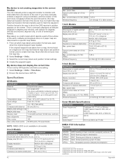
... .) 18 W 1 A 1.5 A 2.4 GHz @ 18.5 dBm nominal Sonar Models Specifications Specification Sonar frequencies1 Measurement Traditional: 50, 77, 83, or 200 kHz CHIRP Garmin ClearVü: 260, 455, or 800 kHz CHIRP SideVü: 260, 455, or 800 kHz Sonar transmit power (RMS)2 Sonar depth3 500 W 701 m (2,300... 3 A, 125 V fast-acting Compass-safe distance 65 cm (25.6 in .) 15 W, 9 W with options for up to www.garmin.com /waterrating. If you have manually entered a waypoint using coordinates, and the location of the point does not appear where the point should be , the map datum and position...
... .) 18 W 1 A 1.5 A 2.4 GHz @ 18.5 dBm nominal Sonar Models Specifications Specification Sonar frequencies1 Measurement Traditional: 50, 77, 83, or 200 kHz CHIRP Garmin ClearVü: 260, 455, or 800 kHz CHIRP SideVü: 260, 455, or 800 kHz Sonar transmit power (RMS)2 Sonar depth3 500 W 701 m (2,300... 3 A, 125 V fast-acting Compass-safe distance 65 cm (25.6 in .) 15 W, 9 W with options for up to www.garmin.com /waterrating. If you have manually entered a waypoint using coordinates, and the location of the point does not appear where the point should be , the map datum and position...