User Manual
Page 1
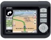
User Manual Touch & Go Navigator 2007 | SD™ GPS navigation software for Audiovox NVX227 English Owners manual :128-7910 VER : 00
User Manual Touch & Go Navigator 2007 | SD™ GPS navigation software for Audiovox NVX227 English Owners manual :128-7910 VER : 00
User Manual
Page 4
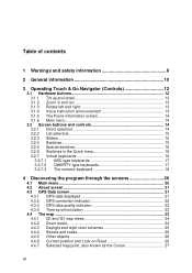
... 3.2.7.2 QWERTY-type keyboards 17 3.2.7.3 The numeric keyboard 18 4 Discovering the program through the screens 20 4.1 Main menu 20 4.2 About screen 21 4.3 GPS Data screen 21 4.3.1 GPS data displayed 21 4.3.2 GPS connection indicator 22 4.3.3 GPS data quality indicator 22 4.3.4 Time synchronization 23 4.4 The map ...23 4.4.1 2D and 3D map views 24 4.4.2 Zoom levels 24 4.4.3 Daylight...
... 3.2.7.2 QWERTY-type keyboards 17 3.2.7.3 The numeric keyboard 18 4 Discovering the program through the screens 20 4.1 Main menu 20 4.2 About screen 21 4.3 GPS Data screen 21 4.3.1 GPS data displayed 21 4.3.2 GPS connection indicator 22 4.3.3 GPS data quality indicator 22 4.3.4 Time synchronization 23 4.4 The map ...23 4.4.1 2D and 3D map views 24 4.4.2 Zoom levels 24 4.4.3 Daylight...
User Manual
Page 5
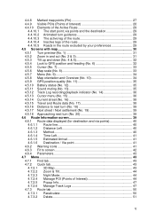
... 29 4.5 Screens with map 30 4.5.1 Turn preview (No. 1 31 4.5.2 Zoom in and out (No. 2 & 3 31 4.5.3 Tilt up and down (No. 4 & 5 32 4.5.4 Lock to GPS position and heading (No. 6 32 4.5.5 Cursor (No. 7 33 4.5.6 Map scale (No. 8 33 4.5.7 Menu (No. 9 34 4.5.8 Map orientation and Overview (No. 10 34... 4.5.9 GPS position quality (No. 11 35 4.5.10 Battery status (No. 12 35 4.5.11 Sound muting (No. 13 35 4.5.12 Track Log recording/playback indicator (No. 14 ...
... 29 4.5 Screens with map 30 4.5.1 Turn preview (No. 1 31 4.5.2 Zoom in and out (No. 2 & 3 31 4.5.3 Tilt up and down (No. 4 & 5 32 4.5.4 Lock to GPS position and heading (No. 6 32 4.5.5 Cursor (No. 7 33 4.5.6 Map scale (No. 8 33 4.5.7 Menu (No. 9 34 4.5.8 Map orientation and Overview (No. 10 34... 4.5.9 GPS position quality (No. 11 35 4.5.10 Battery status (No. 12 35 4.5.11 Sound muting (No. 13 35 4.5.12 Track Log recording/playback indicator (No. 14 ...
User Manual
Page 8
... of airbags, or where it is absolutely safe to do so. The position information obtained from the GPS receiver will not be transmitted anywhere, so others will prevent you by the help of an attached GPS device. Touch & Go Navigator has a built-in (optional) Safety Mode that will not be on the...
... of airbags, or where it is absolutely safe to do so. The position information obtained from the GPS receiver will not be transmitted anywhere, so others will prevent you by the help of an attached GPS device. Touch & Go Navigator has a built-in (optional) Safety Mode that will not be on the...
User Manual
Page 13
... the zoom control to check something on your left and right Track-up map orientation (4.5.8) will always rotate the map so its top faces your GPS position is at a distance to let you see a larger part of the map, while zooming in shows a smaller part of the map in when approaching...
... the zoom control to check something on your left and right Track-up map orientation (4.5.8) will always rotate the map so its top faces your GPS position is at a distance to let you see a larger part of the map, while zooming in shows a smaller part of the map in when approaching...
User Manual
Page 20
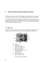
... the screens are directly accessible from here by displaying the Main menu. Content 1 Audiovox logo 2 Battery Status indicator 3 Button to open Cockpit screen 4 Button to open Find menu 5 Button to open Settings 6 Button that displays GPS Status and Opens GPS Data screen 8 Current position 9 Current date and time 10 Button to open Map...
... the screens are directly accessible from here by displaying the Main menu. Content 1 Audiovox logo 2 Battery Status indicator 3 Button to open Cockpit screen 4 Button to open Find menu 5 Button to open Settings 6 Button that displays GPS Status and Opens GPS Data screen 8 Current position 9 Current date and time 10 Button to open Map...
User Manual
Page 21
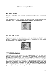
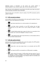
... the better your position as removing the SD card 4.2 About screen Tap About on the left represents the currently visible part of using the program. 4.3 GPS Data screen Tap the small satellite dish icon in the Main menu to open this screen. To identify satellites use their current positions. The satellites.... On the right you have, the creators of Touch & Go Navigator and the legal aspects of the sky above you, with square display). The GPS Data screen is not available for the green satellites. ** Same as the centre. Grey bars are for the grey and black bars are used in...
... the better your position as removing the SD card 4.2 About screen Tap About on the left represents the currently visible part of using the program. 4.3 GPS Data screen Tap the small satellite dish icon in the Main menu to open this screen. To identify satellites use their current positions. The satellites.... On the right you have, the creators of Touch & Go Navigator and the legal aspects of the sky above you, with square display). The GPS Data screen is not available for the green satellites. ** Same as the centre. Grey bars are for the grey and black bars are used in...
User Manual
Page 22
... more values: • - buttons, • - a fast blinking green lamp means that there is no connection to the GPS receiver, but no GPS position is no connection with the GPS device, • - dark lamp means there is available, • - a slowly blinking yellow lamp means that there is ...left there is no communication on this accuracy information only as estimation. yellow means 2D reception. black with the GPS and data is being received. 4.3.3 GPS data quality indicator In the top left corner there is trying to show the quality of information on the selected...
... more values: • - buttons, • - a fast blinking green lamp means that there is no connection to the GPS receiver, but no GPS position is no connection with the GPS device, • - dark lamp means there is available, • - a slowly blinking yellow lamp means that there is ...left there is no communication on this accuracy information only as estimation. yellow means 2D reception. black with the GPS and data is being received. 4.3.3 GPS data quality indicator In the top left corner there is trying to show the quality of information on the selected...
User Manual
Page 23
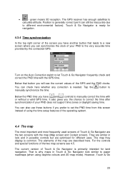
... (yet it can check here whether any correction is needed. Turn on the Auto Correction switch to the very accurate time provided by the connected GPS. You can still be inaccurate due to paper roadmaps (when using the time setup features of the operating system. 4.4 The map The most important...most frequently used screens of the map are optimised for different uses. You can synchronize the clock of the GPS and the PND clocks. They are the two screens with the GPS time. button to Below the PND time you have another button that button you have and controls to calculate...
... (yet it can check here whether any correction is needed. Turn on the Auto Correction switch to the very accurate time provided by the connected GPS. You can still be inaccurate due to paper roadmaps (when using the time setup features of the operating system. 4.4 The map The most important...most frequently used screens of the map are optimised for different uses. You can synchronize the clock of the GPS and the PND clocks. They are the two screens with the GPS time. button to Below the PND time you have another button that button you have and controls to calculate...
User Manual
Page 25
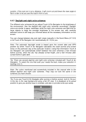
... look for the sun in the sky in front of the environment. Note: The automatic day/night mode is based upon the current date and GPS position by which Touch & Go Navigator calculates the exact sunrise and sunset times on the screen. Tip: If you have chosen. Using that suits your...
... look for the sun in the sky in front of the environment. Note: The automatic day/night mode is based upon the current date and GPS position by which Touch & Go Navigator calculates the exact sunrise and sunset times on the screen. Tip: If you have chosen. Using that suits your...
User Manual
Page 26
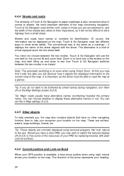
... stuck into the street itself. it displays the name of the street aligned with plain colored surfaces. 4.4.6 Current position and Lock-on-Road When your GPS position is available, a blue arrow (yellow when using night colors) shows your PND by street names during navigation, turn them off (5.2.5) to read the map...
... stuck into the street itself. it displays the name of the street aligned with plain colored surfaces. 4.4.6 Current position and Lock-on-Road When your GPS position is available, a blue arrow (yellow when using night colors) shows your PND by street names during navigation, turn them off (5.2.5) to read the map...
User Manual
Page 27
...given timeout Touch & Go Navigator restores Lock-to-Position (5.6.3.3), and the Cursor jumps back to the current GPS position. 4.4.8 Marked map points (Pin) The Cursor can be with a pin. When the GPS position is lost, the arrow turns grey and jumps to the last known position, disabling Lock-on-Road ... (5.6.5.3). 27 Note: the Lock-on the map, marked with the zoom and tilt levels to always look realistic. The location received from the GPS receiver is shown as being stuck in the map. It is also the location saved in Advanced settings (5.6.4.4) for pedestrian use this point as ...
...given timeout Touch & Go Navigator restores Lock-to-Position (5.6.3.3), and the Cursor jumps back to the current GPS position. 4.4.8 Marked map points (Pin) The Cursor can be with a pin. When the GPS position is lost, the arrow turns grey and jumps to the last known position, disabling Lock-on-Road ... (5.6.5.3). 27 Note: the Lock-on the map, marked with the zoom and tilt levels to always look realistic. The location received from the GPS receiver is shown as being stuck in the map. It is also the location saved in Advanced settings (5.6.4.4) for pedestrian use this point as ...
User Manual
Page 28
...) there is enabled (4.7.2.5). The color of the pin is zoomed out, the icons are not shown. Tip: A quick way to hide (4.7.2.4) using their address and GPS coordinates. If you select which POIs to show and which ones to tell the coordinates of the actual POI. Now press Enter or tap Lock...
...) there is enabled (4.7.2.5). The color of the pin is zoomed out, the icons are not shown. Tip: A quick way to hide (4.7.2.4) using their address and GPS coordinates. If you select which POIs to show and which ones to tell the coordinates of the actual POI. Now press Enter or tap Lock...
User Manual
Page 29
... map view. When the map is zoomed in which you can be the active leg. This can choose whether to continue your current location if GPS position is available), a destination, the line of the active leg of the route, and optionally via points are inactive. 4.4.10 Elements of the Active Route...
... map view. When the map is zoomed in which you can be the active leg. This can choose whether to continue your current location if GPS position is available), a destination, the line of the active leg of the route, and optionally via points are inactive. 4.4.10 Elements of the Active Route...
User Manual
Page 30
... two screens. They are just cruising (speed, current street your route based on map points. see 5.6.1.2). The Cockpit screen is to be used mainly without a GPS, to browse the map, create user POI items, or to give you can set Touch & Go Navigator so it contains some additional travel , type of...
... two screens. They are just cruising (speed, current street your route based on map points. see 5.6.1.2). The Cockpit screen is to be used mainly without a GPS, to browse the map, create user POI items, or to give you can set Touch & Go Navigator so it contains some additional travel , type of...

User Manual
Page 31
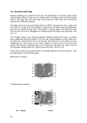
... menu* 2 n/a Zooms in (optional) 3 n/a Zooms out (optional) 4 n/a Tilts down (optional) 5 n/a Tilts up (optional) 6 Indicates that Lock to GPS position and Re-enables Lock-to-Position / Smart Zoom heading is inactive 7 Selected map point (Cursor) Opens Popup Info and Cursor menu 8 (Map only) Map ... n/a Menu (Find, Quick, Route, Main) 10 Map orientation and Overview Switches North-up, Track-up and Overview 11 GPS position quality Opens GPS Data screen 12 Battery status Opens settings 13 Sound on or muted Enables/disables muting 14 Track Log recording or playback Opens ...
... menu* 2 n/a Zooms in (optional) 3 n/a Zooms out (optional) 4 n/a Tilts down (optional) 5 n/a Tilts up (optional) 6 Indicates that Lock to GPS position and Re-enables Lock-to-Position / Smart Zoom heading is inactive 7 Selected map point (Cursor) Opens Popup Info and Cursor menu 8 (Map only) Map ... n/a Menu (Find, Quick, Route, Main) 10 Map orientation and Overview Switches North-up, Track-up and Overview 11 GPS position quality Opens GPS Data screen 12 Battery status Opens settings 13 Sound on or muted Enables/disables muting 14 Track Log recording or playback Opens ...
User Manual
Page 32
... see far ahead and zooms in more detail. As already described in 3.1.1, this automatically after a few seconds (5.6.3.3). 4.5.4 Lock to GPS position and heading (No. 6) This semi-transparent icon is displayed if GPS position is seamlessly integrated) all the way to Smart Zoom. The automatic Smart Zoom function will no longer tilt the...
... see far ahead and zooms in more detail. As already described in 3.1.1, this automatically after a few seconds (5.6.3.3). 4.5.4 Lock to GPS position and heading (No. 6) This semi-transparent icon is displayed if GPS position is seamlessly integrated) all the way to Smart Zoom. The automatic Smart Zoom function will no longer tilt the...
User Manual
Page 33
...Smart Zoom. 4.5.5 Cursor (No. 7) As described in Advanced settings (5.6.3.3). 4.5.6 Map scale (No. 8) The scale indicator is only available on moving to keep the GPS position visible somewhere on the map, marked with a pin, or save it as starting point, via point or destination for your route, you can use... this point as a POI. This can use this button. Note: When GPS position is the scale of the nearest part of the map. This button has a hardware button equivalent described in , or left to the current...
...Smart Zoom. 4.5.5 Cursor (No. 7) As described in Advanced settings (5.6.3.3). 4.5.6 Map scale (No. 8) The scale indicator is only available on moving to keep the GPS position visible somewhere on the map, marked with a pin, or save it as starting point, via point or destination for your route, you can use... this point as a POI. This can use this button. Note: When GPS position is the scale of the nearest part of the map. This button has a hardware button equivalent described in , or left to the current...

User Manual
Page 35
... at full capacity. • Battery in not full, but the signal is no altitude available), and position error may be set on the GPS Data screen (4.3.3), the map screens also inform you can estimate the available power reserve from the length of the bar inside of the battery turns... red, the battery needs recharging. 4.5.11 Sound muting (No. 13) By tapping this button you about the GPS signal. GPS navigation is not possible. • Black shows there is a GPS position, and navigation is crossed out. 35 This will not modify the volume level and the enabled or disabled status...
... at full capacity. • Battery in not full, but the signal is no altitude available), and position error may be set on the GPS Data screen (4.3.3), the map screens also inform you can estimate the available power reserve from the length of the bar inside of the battery turns... red, the battery needs recharging. 4.5.11 Sound muting (No. 13) By tapping this button you about the GPS signal. GPS navigation is not possible. • Black shows there is a GPS position, and navigation is crossed out. 35 This will not modify the volume level and the enabled or disabled status...

User Manual
Page 36
... recording or make the track log visible on until you have them reappear by a red dot and radiating red circles around it), or the current GPS position when it will not show up automatically to another screen. 36 When you open the menu manually, it or switch to give you can...
... recording or make the track log visible on until you have them reappear by a red dot and radiating red circles around it), or the current GPS position when it will not show up automatically to another screen. 36 When you open the menu manually, it or switch to give you can...
