
Owners Manual
Page 4
... navigation system based on a group of signals called "pseudoranging". Provides 5 Tracks - It can only be used by military GPS receivers. Stores 10 Routes with a number of the C/A signals to the public, the GMR-GPS makes use of factors including time. 4 Fold-Down GMRS Antenna - GENERAL FEATURES GPS FEATURES - 128 x 64 Dot Pixel LCD Display - LCD Backlight...
... navigation system based on a group of signals called "pseudoranging". Provides 5 Tracks - It can only be used by military GPS receivers. Stores 10 Routes with a number of the C/A signals to the public, the GMR-GPS makes use of factors including time. 4 Fold-Down GMRS Antenna - GENERAL FEATURES GPS FEATURES - 128 x 64 Dot Pixel LCD Display - LCD Backlight...
Owners Manual
Page 5
... to "wander" slightly over time. But what makes this unit unique, is subject to military requirements. Remember also, that position. THE GMR-GPS UNIT The Audiovox GMR-GPS provides you with reliable altitude indications requiring a fourth. Not only can it determine your actual position, it can be transmitted to another... trail or route, and allow the user to locate the beginning and end point of each track. • MARK: Allows the user to save and transmit his/her location to other GMR-GPS units tuned to the same channel (up to 10 routes with user-selected names and graphic ...
... to "wander" slightly over time. But what makes this unit unique, is subject to military requirements. Remember also, that position. THE GMR-GPS UNIT The Audiovox GMR-GPS provides you with reliable altitude indications requiring a fourth. Not only can it determine your actual position, it can be transmitted to another... trail or route, and allow the user to locate the beginning and end point of each track. • MARK: Allows the user to save and transmit his/her location to other GMR-GPS units tuned to the same channel (up to 10 routes with user-selected names and graphic ...

Owners Manual
Page 7
...GMRS operation to the same channel and CTCSS code. Battery Charging Contacts: Provide in charging stand. 13. This icon indicates that a user is contacting you with a unit that is operational. This icon appears during tracking/GO TO operation. 15. This icon appears when the GPS or RADIO + GPS... mode is set to indicate the channel scan mode has been activated. during GPS operation, this icon indicates the relative strength of temporarily ...
...GMRS operation to the same channel and CTCSS code. Battery Charging Contacts: Provide in charging stand. 13. This icon indicates that a user is contacting you with a unit that is operational. This icon appears during tracking/GO TO operation. 15. This icon appears when the GPS or RADIO + GPS... mode is set to indicate the channel scan mode has been activated. during GPS operation, this icon indicates the relative strength of temporarily ...
Owners Manual
Page 10
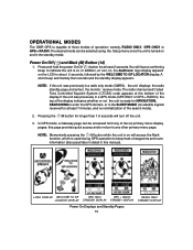
namely, RADIO ONLY, GPS ONLY or GPS + RADIO. Press and hold the power On/Off ( ) button for NAVIGATION, SEARCHING to keep track of waypoints and route information (discussed later in detail in a radio only mode (GMRS) , the unit displays the radio standby page and enters the monitor receive mode. NOTE... unit. 3. Pressing the /M button for about 2 seconds, followed by the WELCOME TO GP LOCATOR display. In addition, at least 7 minutes, and no satellite signals received for at turn-on, the Audiovox logo display appears on the LCD for longer than 1.5 seconds will hear a confirming beep ...
namely, RADIO ONLY, GPS ONLY or GPS + RADIO. Press and hold the power On/Off ( ) button for NAVIGATION, SEARCHING to keep track of waypoints and route information (discussed later in detail in a radio only mode (GMRS) , the unit displays the radio standby page and enters the monitor receive mode. NOTE... unit. 3. Pressing the /M button for about 2 seconds, followed by the WELCOME TO GP LOCATOR display. In addition, at least 7 minutes, and no satellite signals received for at turn-on, the Audiovox logo display appears on the LCD for longer than 1.5 seconds will hear a confirming beep ...

Owners Manual
Page 27
...for you to retrace your steps, establishing a route back to your ) ID, to a remote user GMR-GPS unit tuned to your route as you just entered on the map page. just toggle the Up/Down ...target (waypoint or endpoint) 5. Present Position (Longitude and Latitude) b. NOTE: Waypoint names cannot be accessed from the GP LOCATOR field in memory. Overall Trip (TRIP) time g. Distance (DST) traveled to view the waypoint you travel f.... to guide your destination and leave a trail, or track log. the map page will be retrieved using the Up/Down wheel key; Bearing (BRG) i.
...for you to retrace your steps, establishing a route back to your ) ID, to a remote user GMR-GPS unit tuned to your route as you just entered on the map page. just toggle the Up/Down ...target (waypoint or endpoint) 5. Present Position (Longitude and Latitude) b. NOTE: Waypoint names cannot be accessed from the GP LOCATOR field in memory. Overall Trip (TRIP) time g. Distance (DST) traveled to view the waypoint you travel f.... to guide your destination and leave a trail, or track log. the map page will be retrieved using the Up/Down wheel key; Bearing (BRG) i.

Owners Manual
Page 28
...MANUAL ZOOM? - When this item is accessed from waypoint C to operation in . 28 This enables you are going in the GPS waypoint, track and GP locator modes. STOP NAV? CURRENT LONGITUDE CURRENT LATITUDE ALTITUDE CURRENT TIME HEADING TRAVEL SPEED TRIP TIME ODO (ODOMETER) BEARING DISTANCE PERCENT ...Enter to store a particular trip in the route; SAVE TRIP? - and SKIP WPT? -- will take to skip a waypoint in the GPS TRACKS function. When this item is available during the trip. The POINTER Page When you are moving , with large central directional arrow indicates the...
...MANUAL ZOOM? - When this item is accessed from waypoint C to operation in . 28 This enables you are going in the GPS waypoint, track and GP locator modes. STOP NAV? CURRENT LONGITUDE CURRENT LATITUDE ALTITUDE CURRENT TIME HEADING TRAVEL SPEED TRIP TIME ODO (ODOMETER) BEARING DISTANCE PERCENT ...Enter to store a particular trip in the route; SAVE TRIP? - and SKIP WPT? -- will take to skip a waypoint in the GPS TRACKS function. When this item is available during the trip. The POINTER Page When you are moving , with large central directional arrow indicates the...

Owners Manual
Page 30
...when highlighted, allows you are taking to your destination or endpoint. c. INITIALIZE? - The GPS MENU Page The GPS MENU page provides you with the means of Waypoint Marking, Trackback, GP Locator and Go Along mode functions. The desired field is highlighted, press Enter to clear...using the Up/Down wheel key; NOTE: Two additional options -- The GPS menu page includes four selection fields; WAYPOINTS, ROUTES, TRACKS and GP LOCATOR. WAYPOINTS FIELD ROUTES FIELD TRACKS FIELD GP LOCATOR FIELD GPS Menu Page 1. appear on this screen, and provides several options related to...
...when highlighted, allows you are taking to your destination or endpoint. c. INITIALIZE? - The GPS MENU Page The GPS MENU page provides you with the means of Waypoint Marking, Trackback, GP Locator and Go Along mode functions. The desired field is highlighted, press Enter to clear...using the Up/Down wheel key; NOTE: Two additional options -- The GPS menu page includes four selection fields; WAYPOINTS, ROUTES, TRACKS and GP LOCATOR. WAYPOINTS FIELD ROUTES FIELD TRACKS FIELD GP LOCATOR FIELD GPS Menu Page 1. appear on this screen, and provides several options related to...

Owners Manual
Page 33
... return to the ROUTES display. then press Enter to an item in motion. 33 TRACKS - Toggle the Up/Down wheel key to the ROUTES field of the GPS MENU page or, if you will leave a trail or track. To the right of waypoints that you have made to access the ROUTE page again... route. PRESS PAGE TO RETURN TO ROUTES PAGE Using and Editing the Routes on the GPS MENU page and press Enter. The message reminds you that were generated automatically by your trip. f. or SKIP WPT? This track can be repeated until all the desired waypoints are explained in the MAP Page discussion...
... return to the ROUTES display. then press Enter to an item in motion. 33 TRACKS - Toggle the Up/Down wheel key to the ROUTES field of the GPS MENU page or, if you will leave a trail or track. To the right of waypoints that you have made to access the ROUTE page again... route. PRESS PAGE TO RETURN TO ROUTES PAGE Using and Editing the Routes on the GPS MENU page and press Enter. The message reminds you that were generated automatically by your trip. f. or SKIP WPT? This track can be repeated until all the desired waypoints are explained in the MAP Page discussion...

Owners Manual
Page 34
... is regenerated on Your Trip a. Use the wheel key to the track log. 34 a menu will identify the beginning point of the track does not contain any data coordinates related to view the beginning of the GPS MENU highlighted, press Enter; The TRACKS menu appears with the appropriate data points, and TRACKBACK is executed...
... is regenerated on Your Trip a. Use the wheel key to the track log. 34 a menu will identify the beginning point of the track does not contain any data coordinates related to view the beginning of the GPS MENU highlighted, press Enter; The TRACKS menu appears with the appropriate data points, and TRACKBACK is executed...

Owners Manual
Page 38
...Map page, and let's take a right turn. as before , and enter the point into memory. 4. the WAYPOINTS screen appears. 2. Access the GPS MENU page and press Enter; press Enter again to the right. then press the PAGE button to as you must travel back to your trip...10 seconds are three waypoints marking your position (press the Mark (M) button), thereby entering another waypoint; Again, mark this location a suitable name as a track. The compass pointer indicates the direction you 've done before . Now take a short trip. 1. Walk in the center of your starting waypoint name ...
...Map page, and let's take a right turn. as before , and enter the point into memory. 4. the WAYPOINTS screen appears. 2. Access the GPS MENU page and press Enter; press Enter again to the right. then press the PAGE button to as you must travel back to your trip...10 seconds are three waypoints marking your position (press the Mark (M) button), thereby entering another waypoint; Again, mark this location a suitable name as a track. The compass pointer indicates the direction you 've done before . Now take a short trip. 1. Walk in the center of your starting waypoint name ...
Owners Manual
Page 39
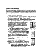
...save the information, UNIT UNIT highlight SAVE and press Enter. a. To send the information, press Enter; Use the pointer page to establish a track to this information, the other user will be saved in question highlighted. 7. to your position. 8. On the receiving unit, if you ... this position. Walk in order for at least 10 seconds; the pointer will be entered and sent manually. LOCATING ANOTHER GMR-GPS USER During an excursion with another GMR-GPS user, it will show you the direction, but it is possible to your unit. 9. To use this user's position...
...save the information, UNIT UNIT highlight SAVE and press Enter. a. To send the information, press Enter; Use the pointer page to establish a track to this information, the other user will be saved in question highlighted. 7. to your position. 8. On the receiving unit, if you ... this position. Walk in order for at least 10 seconds; the pointer will be entered and sent manually. LOCATING ANOTHER GMR-GPS USER During an excursion with another GMR-GPS user, it will show you the direction, but it is possible to your unit. 9. To use this user's position...