Navigation User's Manual (english)
Page 3
...keyboards...9 2.1.2 Beyond single screen tap...10 2.2 Map screen...11 2.2.1 Navigating on the map ...11 2.2.2 Position markers...14 2.2.2.1 Vehimarker and Lock-on-Road...14 2.2.2.2 Selected map location (Cursor) and selected map object 14 2.2.3 Objects on the map...14 2.2.3.1 Streets and roads...14 2.2.3.2 Turn...Elements of the active route ...18 2.2.3.8 Traffic events ...18 2.2.4 Manipulating the map ...19 2.2.5 Checking the details of the current position (Where Am I 21 2.3 Navigation menu ...22 3 On-road navigation ...23 3.1 Selecting the destination of a route 23 3.1.1 Entering an address...
...keyboards...9 2.1.2 Beyond single screen tap...10 2.2 Map screen...11 2.2.1 Navigating on the map ...11 2.2.2 Position markers...14 2.2.2.1 Vehimarker and Lock-on-Road...14 2.2.2.2 Selected map location (Cursor) and selected map object 14 2.2.3 Objects on the map...14 2.2.3.1 Streets and roads...14 2.2.3.2 Turn...Elements of the active route ...18 2.2.3.8 Traffic events ...18 2.2.4 Manipulating the map ...19 2.2.5 Checking the details of the current position (Where Am I 21 2.3 Navigation menu ...22 3 On-road navigation ...23 3.1 Selecting the destination of a route 23 3.1.1 Entering an address...
Navigation User's Manual (english)
Page 4
...51 3.1.7 Entering the coordinate of the destination 52 3.1.8 Navigate to a location stored in a picture 53 3.1.9 Building a route from the list of destinations (Create Route 54 3.2 Viewing the entire route on the map 55 3.3 Modifying the route ...55 3.3.1 Selecting a new... planning ...67 5.1.5.1 Historical traffic...67 5.1.5.2 Real-time traffic information (TMC) (INE-Z928HD/INE-NAV-38 only 67 5.2 Information menu ...69 5.3 Settings menu ...70 5.3.1 Sound and Warnings ...72 5.3.2 Traffic settings ...74 5.3.3 Route settings...74 5.3.4 Map settings...78 5.3.5 Visual guidance settings...79 4
...51 3.1.7 Entering the coordinate of the destination 52 3.1.8 Navigate to a location stored in a picture 53 3.1.9 Building a route from the list of destinations (Create Route 54 3.2 Viewing the entire route on the map 55 3.3 Modifying the route ...55 3.3.1 Selecting a new... planning ...67 5.1.5.1 Historical traffic...67 5.1.5.2 Real-time traffic information (TMC) (INE-Z928HD/INE-NAV-38 only 67 5.2 Information menu ...69 5.3 Settings menu ...70 5.3.1 Sound and Warnings ...72 5.3.2 Traffic settings ...74 5.3.3 Route settings...74 5.3.4 Map settings...78 5.3.5 Visual guidance settings...79 4
Navigation User's Manual (english)
Page 11
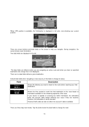
... transparent. Simply tap the audio part and drag it in the desired direction. 2.2 Map screen 2.2.1 Navigating on keyboard screens: you can delete several characters quickly. • Tap and hold on the map The Map screen is the most frequently used screen of the software. When there is no GPS position, the Vehimarker... (drag&drop) You need to drag and drop the screen only in the top left corner. Tap to reduce the map size to half and allow information from your Alpine unit audio system to get the valid GPS position. 11 You see , the closer you are to appear on a slider. ...
... transparent. Simply tap the audio part and drag it in the desired direction. 2.2 Map screen 2.2.1 Navigating on keyboard screens: you can delete several characters quickly. • Tap and hold on the map The Map screen is the most frequently used screen of the software. When there is no GPS position, the Vehimarker... (drag&drop) You need to drag and drop the screen only in the top left corner. Tap to reduce the map size to half and allow information from your Alpine unit audio system to get the valid GPS position. 11 You see , the closer you are to appear on a slider. ...
Navigation User's Manual (english)
Page 12
... the route before reaching your current position. There are displayed on information available for the remaining segments of the route based on the left. During navigation, the screen shows route information. However, this calculation is not displayed). When GPS position is available, the Vehimarker is displayed in full color,.... Shows the time needed to change its value): Field Description Shows the distance you need to travel on the screen to help you navigate. There are three map view modes. There are no specified destination (the orange line is rarely accurate.
... the route before reaching your current position. There are displayed on information available for the remaining segments of the route based on the left. During navigation, the screen shows route information. However, this calculation is not displayed). When GPS position is available, the Vehimarker is displayed in full color,.... Shows the time needed to change its value): Field Description Shows the distance you need to travel on the screen to help you navigate. There are three map view modes. There are no specified destination (the orange line is rarely accurate.
Navigation User's Manual (english)
Page 14
... and roads The software shows the streets in the following ways: • Tap the map when navigating, • Tap the map when you can get information about this object or use it as one of the road. If roads are asked to the direction of your ...: you can easily tell a freeway from a small street. 14 You can also select some of a search, or • Tap the map in Settings. By default, this icon in Find on the map. When on-road navigation is a blue arrow, but you can change this marker is selected, the Vehimarker may not show them.
... and roads The software shows the streets in the following ways: • Tap the map when navigating, • Tap the map when you can get information about this object or use it as one of the road. If roads are asked to the direction of your ...: you can easily tell a freeway from a small street. 14 You can also select some of a search, or • Tap the map in Settings. By default, this icon in Find on the map. When on-road navigation is a blue arrow, but you can change this marker is selected, the Vehimarker may not show them.
Navigation User's Manual (english)
Page 15
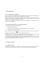
... (turn, traffic circle, exiting freeway, etc.) and its distance from the current position are very intuitive. Turn back. The following table lists some of the Map screen shows information about the next route event (maneuver) and the next street or the next city/town. Keep left . Exit freeway. 2.2.3.2 Turn preview and...
... (turn, traffic circle, exiting freeway, etc.) and its distance from the current position are very intuitive. Turn back. The following table lists some of the Map screen shows information about the next route event (maneuver) and the next street or the next city/town. Keep left . Exit freeway. 2.2.3.2 Turn preview and...
Navigation User's Manual (english)
Page 16
...information. • Tap the Next street field to open the Itinerary. 2.2.3.3 Lane information and Signposts When navigating on multilane roads, it is important to take the appropriate lane in the map data, the software displays the lanes and their directions using small arrows at the top of the signposts... received. This feature can see above road or by the roadside. all others are displayed at the top of them and the normal Map screen returns until new signpost information is no recommended route). The lanes you want to follow the recommended route. Highlighted arrows represent the...
...information. • Tap the Next street field to open the Itinerary. 2.2.3.3 Lane information and Signposts When navigating on multilane roads, it is important to take the appropriate lane in the map data, the software displays the lanes and their directions using small arrows at the top of the signposts... received. This feature can see above road or by the roadside. all others are displayed at the top of them and the normal Map screen returns until new signpost information is no recommended route). The lanes you want to follow the recommended route. Highlighted arrows represent the...
Navigation User's Manual (english)
Page 17
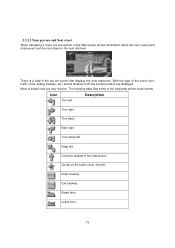
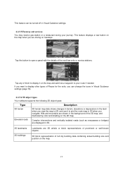
...illustrated by color and shading on the 2D map. Tap any of them to display it on the map and add it to plot the route map in 3D when you navigate. This feature displays a new button on the map when you are driving on the map. 17 This feature can change the icons in... Visual Guidance settings (page 79). 2.2.3.6 3D object types Your software supports the following 3D object types: Type Description 3D terrain 3D terrain map data shows ...
...illustrated by color and shading on the 2D map. Tap any of them to display it on the map and add it to plot the route map in 3D when you navigate. This feature displays a new button on the map when you are driving on the map. 17 This feature can change the icons in... Visual Guidance settings (page 79). 2.2.3.6 3D object types Your software supports the following 3D object types: Type Description 3D terrain 3D terrain map data shows ...
Navigation User's Manual (english)
Page 18
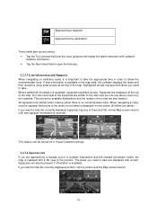
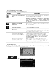
...the last known position as the start point. 2.2.3.7 Elements of the route. Normally if GPS position is available, the route starts from the navigation Streets and roads that are excluded from the current position. Road segments may be affected by traffic events are near, it will include them ... in the following way: Symbol Name Description Current GPS position and Start point Your current position displayed on the map. If roads are displayed with an alternate color on the map, both in daytime and in a color that are affected by traffic events The route always stands out with...
...the last known position as the start point. 2.2.3.7 Elements of the route. Normally if GPS position is available, the route starts from the navigation Streets and roads that are excluded from the current position. Road segments may be affected by traffic events are near, it will include them ... in the following way: Symbol Name Description Current GPS position and Start point Your current position displayed on the map. If roads are displayed with an alternate color on the map, both in daytime and in a color that are affected by traffic events The route always stands out with...
Navigation User's Manual (english)
Page 19
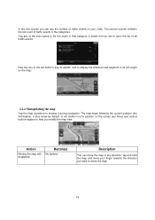
... The second column contains the full count of all traffic events: Now tap any more) and control buttons appear to move your route. The map stops following the current position (the Vehimarker, a blue arrow by default, is not locked in a fix position on the screen any of the list items ...to see the number of traffic events on the map: 2.2.4 Manipulating the map Tap the map anywhere to browse it during navigation. In the first column you modify the map view. Tap any of the even types to list the event in that category or select the...
... The second column contains the full count of all traffic events: Now tap any more) and control buttons appear to move your route. The map stops following the current position (the Vehimarker, a blue arrow by default, is not locked in a fix position on the screen any of the list items ...to see the number of traffic events on the map: 2.2.4 Manipulating the map Tap the map anywhere to browse it during navigation. In the first column you modify the map view. Tap any of the even types to list the event in that category or select the...

Navigation User's Manual (english)
Page 20
... out , Tilting up and down , Rotating left and right Compass Location information Return to normal navigation , , , Additional options Select destination Changes how much of additional features like saving the Cursor as a new destination. 20 Automatic map rotation is displayed on the screen. Zooming in large steps, or tap and hold the button...
... out , Tilting up and down , Rotating left and right Compass Location information Return to normal navigation , , , Additional options Select destination Changes how much of additional features like saving the Cursor as a new destination. 20 Automatic map rotation is displayed on the screen. Zooming in large steps, or tap and hold the button...
Navigation User's Manual (english)
Page 21
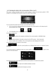
... can access this screen: Tap Information. You can also perform some actions on this screen from the GPS receiver - screen. • In the Navigation menu, tap Information on this screen: and then . • , : Latitude and Longitude (coordinate of the current position in WGS84 format). &#...8226; : Altitude (elevation information coming from the map in one of the following services can also search for useful Places nearby. . to save the current position as an Address Book entry or...
... can access this screen: Tap Information. You can also perform some actions on this screen from the GPS receiver - screen. • In the Navigation menu, tap Information on this screen: and then . • , : Latitude and Longitude (coordinate of the current position in WGS84 format). &#...8226; : Altitude (elevation information coming from the map in one of the following services can also search for useful Places nearby. . to save the current position as an Address Book entry or...

Navigation User's Manual (english)
Page 22
... feature buttons appear below. You have taken or to run some additional applications.. • Tap to customize the way the navigation software works. • Press the MAP hardware button to display the route parameters and the route in a photo. You can reach all parts of the software from... current position, the GPS reception or the trips you open the menu, the destination search buttons appear on the map. Tap any of the buttons, select a Place from the list, and navigate to select your destination by entering an address or selecting a place of interest, a location on the...
... feature buttons appear below. You have taken or to run some additional applications.. • Tap to customize the way the navigation software works. • Press the MAP hardware button to display the route parameters and the route in a photo. You can reach all parts of the software from... current position, the GPS reception or the trips you open the menu, the destination search buttons appear on the map. Tap any of the buttons, select a Place from the list, and navigate to select your destination by entering an address or selecting a place of interest, a location on the...
Navigation User's Manual (english)
Page 23
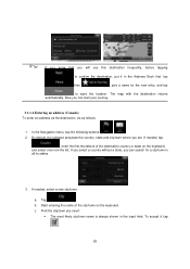
... the same screen, you can add as many destinations to your route as your route to turn off -road navigation. You can find an address or Place (page 48). • Select a location on Map feature (page 49). • Use a previously saved Address Book entry (page 50). • Select a location from the History... GPS position or even without a house number or the names of two intersecting streets (page 23). • Enter an address with the product. 3 On-road navigation When first started, Alpine unit calculates routes using the road network of the high quality vector...
... the same screen, you can add as many destinations to your route as your route to turn off -road navigation. You can find an address or Place (page 48). • Select a location on Map feature (page 49). • Use a previously saved Address Book entry (page 50). • Select a location from the History... GPS position or even without a house number or the names of two intersecting streets (page 23). • Enter an address with the product. 3 On-road navigation When first started, Alpine unit calculates routes using the road network of the high quality vector...
Navigation User's Manual (english)
Page 26
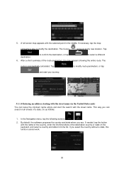
... field. If needed , tap , enter the first few letters of the city/town on the keyboard, and select one from the list. In the Navigation menu, tap the following buttons: , . 2. By default, the software proposes the country, state and city/town where you will use this destination frequently..., before tapping to confirm the destination, put it , tap . 26 The map with the destination returns automatically. If needed , select a new city/town: a. Find the city/town you can search for the new entry, ...
... field. If needed , tap , enter the first few letters of the city/town on the keyboard, and select one from the list. In the Navigation menu, tap the following buttons: , . 2. By default, the software proposes the country, state and city/town where you will use this destination frequently..., before tapping to confirm the destination, put it , tap . 26 The map with the destination returns automatically. If needed , select a new city/town: a. Find the city/town you can search for the new entry, ...

Navigation User's Manual (english)
Page 28
Tap to modify the destination. 6. If necessary, tap the map somewhere else to modify route parameters, or tap and start your journey. 3.1.1.3 Entering an...of the city/town on the keyboard, and select one country from the list of the route parameters, the map appears showing the entire route. In the Navigation menu, tap the following buttons: , . 2. c. to confirm the destination, or tap to select a different... , tap , enter the first few letters of the country name on the keyboard. A full screen map appears with the selected point in the middle. Find the city/town you are.
Tap to modify the destination. 6. If necessary, tap the map somewhere else to modify route parameters, or tap and start your journey. 3.1.1.3 Entering an...of the city/town on the keyboard, and select one country from the list of the route parameters, the map appears showing the entire route. In the Navigation menu, tap the following buttons: , . 2. c. to confirm the destination, or tap to select a different... , tap , enter the first few letters of the country name on the keyboard. A full screen map appears with the selected point in the middle. Find the city/town you are.
Navigation User's Manual (english)
Page 30
... calculated. If needed, tap the button with the name of the country, enter the first few letters of the route parameters, the map appears showing the entire route. Tap destination. After a short summary of the destination country or state on the keyboard, and select a... United States only) You can search in the middle. A full screen map appears with the street name. If necessary, tap the map somewhere else to select a different 6. to confirm the destination, or tap to modify the destination. In the Navigation menu, tap the following buttons: , . 2. 5. The Cursor ( ...
... calculated. If needed, tap the button with the name of the country, enter the first few letters of the route parameters, the map appears showing the entire route. Tap destination. After a short summary of the destination country or state on the keyboard, and select a... United States only) You can search in the middle. A full screen map appears with the street name. If necessary, tap the map somewhere else to select a different 6. to confirm the destination, or tap to modify the destination. In the Navigation menu, tap the following buttons: , . 2. 5. The Cursor ( ...

Navigation User's Manual (english)
Page 33
...that match the string appear in a list after entering a couple of the route parameters, the map appears showing the entire route. c. To accept it appears automatically, tap ). A full screen map appears with the selected point in the input field. to confirm the destination, or tap to modify...After a short summary of characters (to modify the destination. Select the street from the list. 33 5. Tap destination. In the Navigation menu, tap the following buttons: , . 2. b. Find the street you have selected a city/town above, this step is automatically calculated.
...that match the string appear in a list after entering a couple of the route parameters, the map appears showing the entire route. c. To accept it appears automatically, tap ). A full screen map appears with the selected point in the input field. to confirm the destination, or tap to modify...After a short summary of characters (to modify the destination. Select the street from the list. 33 5. Tap destination. In the Navigation menu, tap the following buttons: , . 2. b. Find the street you have selected a city/town above, this step is automatically calculated.

Owner's Manual (english)
Page 18
...Alpine dealer. Point the optional remote control transmitter at least 3 seconds to activate the "Setting the Balance/Fader/Subwoofer" mode. The system turns on. • When turned on the unit, except (Release). • The INE-S920HD/INE-NAV-30 is a precision device. Getting Started For INE-S920HD/INE-NAV-30 Accessory List • INE-S920HD/INE...bold within a range of navigation operations, refer to User 2. (MAP) button Recalls the navigation map screen. Careful handling of the unit should provide you with an optional Alpine remote control. An Alpine Remote Control Interface Box (...
...Alpine dealer. Point the optional remote control transmitter at least 3 seconds to activate the "Setting the Balance/Fader/Subwoofer" mode. The system turns on. • When turned on the unit, except (Release). • The INE-S920HD/INE-NAV-30 is a precision device. Getting Started For INE-S920HD/INE-NAV-30 Accessory List • INE-S920HD/INE...bold within a range of navigation operations, refer to User 2. (MAP) button Recalls the navigation map screen. Careful handling of the unit should provide you with an optional Alpine remote control. An Alpine Remote Control Interface Box (...

Owner's Manual (english)
Page 21
...years of the unit are shown in the separately purchased installation kit for at least 3 seconds to turn the power off. (MAP) button Recalls the navigation map screen. Optional Remote Control Interface Box This unit is already displayed, changes the source. Point the optional remote control transmitter at ... the unit is in radio mode when ignition is reset. For details, contact your Alpine dealer. The system turns on. • When turned on by pressing any button. • The INE-Z928HD/INE-NAV-38 is required. RESET switch The system of this Owner's Manual The buttons ...
...years of the unit are shown in the separately purchased installation kit for at least 3 seconds to turn the power off. (MAP) button Recalls the navigation map screen. Optional Remote Control Interface Box This unit is already displayed, changes the source. Point the optional remote control transmitter at ... the unit is in radio mode when ignition is reset. For details, contact your Alpine dealer. The system turns on. • When turned on by pressing any button. • The INE-Z928HD/INE-NAV-38 is required. RESET switch The system of this Owner's Manual The buttons ...


