
Garmin eTrex 30 Support Question
Garmin eTrex 30 Support Question
Find answers below for this question about Garmin eTrex 30.Need a Garmin eTrex 30 manual? We have 2 online manuals for this item!
Question posted by blBr on April 9th, 2014
How To Calibrate Altimeter In Etrex 30
The person who posted this question about this Garmin product did not include a detailed explanation. Please use the "Request More Information" button to the right if more details would help you to answer this question.
Current Answers
Related Garmin eTrex 30 Manual Pages
Owner's Manual - Page 1

eTrex®
owner's manual
for use with models 10, 20, 30
Owner's Manual - Page 3

...Settings 30
3 Menu 11 Routes 12 Tracks 14
Navigation 16 Navigating to a Destination..........16 Map 16 Compass 17 Elevation Plot 19 Trip Computer 20
eTrex Owner... a Proximity Alarm 24 Calculating the Size of Contents
Getting Started 5 Device Overview 5 Using the eTrex Keys 6 Battery Information 7 Turning the Device On or Off.........8 Satellite Signals 8 Registering Your Device...
Owner's Manual - Page 10

... multiple samples of a location.
3. Move to the object, and select Done > Save.
10
eTrex Owner's Manual Select Start.
5.
Point the device at an object or in the direction, and ...
2. Enter the distance to the location.
4. Using Sight 'N Go
Sight 'N Go is available on the eTrex 30. Select a waypoint.
3. Select Lock Direction > Project Waypoint.
4. For best results, collect four to eight ...
Owner's Manual - Page 11

... all or part of the name, and select Done. Waypoints, Routes, and Tracks
Finding a Location by Name Depending on the maps loaded on the eTrex 20 and eTrex 30, such as BirdsEye™ satellite imagery, BlueChart® g2, TOPO, and City Navigator® detailed maps. Select a category.
3. Enter all areas and maps.
Finding...
Owner's Manual - Page 17

... the map to navigate to your vehicle.
1.
eTrex Owner's Manual
17 Follow the turns in your ...the destination.
3.
Select Profile Change > Automotive.
2.
• Select a location on the eTrex 20 and eTrex 30. Calibrating the Compass
Notice Calibrate the electronic compass outdoors.
Navigating a Driving Route Driving route navigation is using the automotive profile, ...
Owner's Manual - Page 19

between dots on the eTrex 30.
To customize the elevation plot, see page 34. Select an option. Viewing Details about the point appear at the top of the plot. Resetting the Elevation Plot Select Elevation Plot > menu > Reset > Clear Current Track > Yes. eTrex Owner's Manual
19 Select Compass. 3.
Navigating with the course pointer, you...
Owner's Manual - Page 20

...To customize the trip computer, see page 28.
20
eTrex Owner's Manual Follow the on-screen instructions. Select Elevation Plot > menu > Calibrate Altimeter.
3.
Go to zero. Select Trip Computer > menu > Reset > Reset Trip Data > Yes. Navigation
Calibrating the Barometric Altimeter You can manually calibrate the barometric altimeter if you know the correct elevation or the correct barometric...
Owner's Manual - Page 23

eTrex Owner's Manual
23 chirp™
chirp programming and searching is a small Garmin accessory that ... Geocaches.
2. Select Geocaches > menu > Show
chirp™ Details.
2.
Select chirp™ Searching > On.
A chirp is available on the eTrex 30. If available, select Go to navigate to a geocache (page 22). • To enter a comment about looking for the cache or the cache...
Owner's Manual - Page 24

... a specified range of a compatible Garmin device.
1.
Setting a Proximity Alarm
Proximity alarms alert you when you enter a proximity alarm area, the device sounds a tone (eTrex 20/30).
24
eTrex Owner's Manual You can share information wirelessly. Select Proximity Alarms.
2.
Applications
Applications
Sharing Data
The eTrex 30 can share waypoints, geocaches, routes, and tracks.
Owner's Manual - Page 34

... to a course line leading to a destination.
• Compass-switches from an electronic compass to a GPS compass when you turn the device on the eTrex 30. Heading Settings
This function is available on .
34
eTrex Owner's Manual Select Setup > Altimeter.
• Auto Calibration-allows the altimeter to select how the course appears.
◦◦ Bearing (Small or Large...
Owner's Manual - Page 35

...time.
◦◦ Ambient Pressure-records ambient pressure changes over a period of time.
• Calibrate Altimeter-page 20. Geocaching Settings
Select Setup > Geocaches.
• Geocache List-allows you to weather....;◦ Fixed Elevation-assumes the device is stationary at a fixed elevation.
eTrex Owner's Manual
35
Therefore, the barometric pressure should change only due to ...
Owner's Manual - Page 37

...fishing.
• Appearance-allows you to set the appearance of bottom contours and depth soundings.
eTrex Owner's Manual
37 • Lock On Road-locks the position icon, which represents your ...next point on the route.
◦◦ Distance-routes you to the next point on the eTrex 20 and eTrex 30.
Select Setup > Marine.
• Marine Chart Mode-allows you to select a nautical chart...
Owner's Manual - Page 43

...ring counter-clockwise, and pull up , as instructed in the battery compartment.
➊➋
eTrex Owner's Manual
43 File Types The device supports these file types.
• Files from ...the Garmin POI Loader
• GPX geocache files
Device Information
Installing a microSD Card The eTrex 20 and eTrex 30 can use microSD cards for more information.
1. Remove the batteries or battery.
3. ...
Owner's Manual - Page 46

... your device.
Select Heart Rate Monitor or Bike Cadence Sensor.
4. Select Search for the eTrex 30. Before you can use the fitness accessory with your device, you must install the accessory according...8482; wireless technology to send data to view the heart rate or cadence data (page 28).
46
eTrex Owner's Manual
or 3 m) of the ANT+ accessory.
2. You can purchase additional maps, such ...
Owner's Manual - Page 54

...
B backlight
timeout 40 barometer 19 BaseCamp 43 batteries 30, 48
about 41 information 7, 41 installing 7 life 41 long term storage 42 maximizing life 41 selecting the type 7 storage 7 warnings 7 BirdsEye satellite imagery 11 BlueChart g2 maps 11
54
C calculator 25 calendar 25 calibrating
altimeter 20 compass 18 caring for the device 42 long...
Owner's Manual - Page 55

...
profiles 30 routes 12 waypoints 9
eTrex Owner's Manual
elevation plot 19, 20 barometric altimeter 20 of a track 15
F file types 43 finding
addresses 12 near your location 11 fishing times 25 fitness options 46
G geocaches 21, 35
downloading 21 filter list 21 logging attempt 22 navigating to 22 settings 35 GPS signals 8, 26, 30, 47...
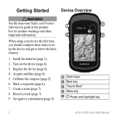
Quick Start Manual - Page 2
...Turn on the device (page 4).
3. Acquire satellites (page 4).
5. Calibrate the compass (page 5).
6. Navigate to know the basic features.
...
➊ Zoom keys ➋ Back key ➌ Thumb Stick™ ➍ Menu key
➎ Power and backlight key
2
eTrex 20/30 Quick Start Manual Record a track (page 7).
9. Install the batteries (page 3).
2. Create a route (page 7).
8. Register the ...
Quick Start Manual - Page 4

...Adjusting the Backlight
Note: The backlight brightness may need a clear view of screen backlighting
eTrex 20/30 Quick Start Manual 2. Select Setup > System > Battery
Type. 6.
The time and... batteries is turned on the GPS position. Select Alkaline, Lithium, or
Rechargeable NiMH. Extensive use of the sky to acquire satellite signals.
When the GPS bars on the backlight page ...
Quick Start Manual - Page 5

... that optimize your settings and views can significantly reduce battery life.
1. The eTrex 30 has a 3-axis, electronic compass. Follow the on , press . 2. Select a profile.
eTrex 20/30 Quick Start Manual
5 Calibrating the Compass
Notice Calibrate the electronic compass outdoors. Select Calibrate Compass > Start.
4. Waypoints
Waypoints are a collection of settings that influence...
Quick Start Manual - Page 8

... one or more or less often.
Select Where To?. 2. Select Go.
The position icon represents your route marked with the Bearing Pointer The eTrex 30 has a 3-axis, electronic compass.
8
eTrex 20/30 Quick Start Manual The map page opens with your location on , a track log is created. Navigate using the map or compass.
1. Navigating...
Similar Questions


Garmin Etrex 30 Language
I have an eTrex 30 and the language not open ,could you please let me know what sall i do?
I have an eTrex 30 and the language not open ,could you please let me know what sall i do?
(Posted by mnazari123 10 years ago)
Garmin Etrex 30 Language Change
I accidentally selected the wrong language on initial start up. How do I set English as the language
I accidentally selected the wrong language on initial start up. How do I set English as the language
(Posted by vk3afw 10 years ago)
