
Garmin eTrex 20 Support Question
Garmin eTrex 20 Support Question
Find answers below for this question about Garmin eTrex 20.Need a Garmin eTrex 20 manual? We have 2 online manuals for this item!
Question posted by glyrobthe on May 27th, 2014
Tutorial On How To Use Garmin Etrex 20
The person who posted this question about this Garmin product did not include a detailed explanation. Please use the "Request More Information" button to the right if more details would help you to answer this question.
Current Answers
Related Garmin eTrex 20 Manual Pages
Owner's Manual - Page 3

...to a Destination..........16 Map 16 Compass 17 Elevation Plot 19 Trip Computer 20
eTrex Owner's Manual
Table of Contents
Geocaches 21 Downloading Geocaches 21 Filtering the Geocache...Alarm 24 Calculating the Size of Contents
Getting Started 5 Device Overview 5 Using the eTrex Keys 6 Battery Information 7 Turning the Device On or Off.........8 Satellite Signals 8 Registering Your Device ...
Owner's Manual - Page 6

... item.
• Press back to move around the map.
• Press the center of commonly-used functions for the current page. Getting Started
➏ ➐
➑ ➒
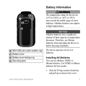
➏ Mini...(under weather cap) ➐ Battery cover ➑ Battery cover locking ring ➒ Mounting spine
Using the eTrex Keys
• Move the Thumb Stick up, down, left, and right to highlight menu selections ...
Owner's Manual - Page 11

... select Done.
Select a category.
3.
Waypoints, Routes, and Tracks
Finding a Location by Name Depending on the maps loaded on your Garmin dealer. Where To? Menu
You can use additional maps on the eTrex 20 and eTrex 30, such as restaurants or marine services. Enter all or part of interest, such as BirdsEye™ satellite imagery, BlueChart...
Owner's Manual - Page 17

... the top of the screen shows information about the selected location. If you plan to use a bearing pointer or a course pointer to navigate to the destination.
3.
• Select a location on the eTrex 20 and eTrex 30.
Follow the turns in your destination. You can use the map, you must purchase and load City Navigator maps.
Owner's Manual - Page 24

....
5.
Select Send or Receive. 3. Select a category.
4. Select Use.
6. Select Done. You can send or receive data when connected to...eTrex 30 can share data wirelessly, you must be within a specified range of a compatible Garmin device.
1.
Setting a Proximity Alarm
Proximity alarms alert you when you enter a proximity alarm area, the device sounds a tone (eTrex 20/30).
24
eTrex...
Owner's Manual - Page 26

... alarm sounds at a specific time.
1. Changing the Satellite View 1. Turning Off GPS Select Satellite > menu > Use With GPS Off.
26
eTrex Owner's Manual Select Turn Alarm On. 4. Satellite Page
The satellite page shows your current track toward the top of that satellite (eTrex 20/30).
Opening the Stopwatch
Select Stopwatch. Select the clock numbers to set...
Owner's Manual - Page 27

Simulating a Location Before you can simulate a location, you must turn off GPS (page 26).
1. Select menu > Set Location On Map.
3.
Select a location.
4. Select Satellite > menu > Use With GPS Off.
2. Select Use. Applications
eTrex Owner's Manual
27
Owner's Manual - Page 30

...see page 40.
• Colors (eTrex 20/30)-sets the colors that display in Night and Day mode...data, such as street names.
• Battery Type-allows you are using. Select a profile. 3. Deleting a Profile 1. Select Done.
Select Delete...or Demo Mode (GPS off . Select Setup > Profiles. 2.
System Settings
Select Setup > System.
• GPS-sets the GPS to http://www.garmin.com/ aboutGPS/...
Owner's Manual - Page 33

... based on the map. Tracks are using a map or chart that specifies a different position format.
You can customize...GPS position. Select Setup > Position Format.
• Position Format-sets the position format in which a given location reading appears. Select a measurement type.
3. eTrex ...Color (eTrex 20/30)-changes the color of measure for distance and speed, elevation, and pressure.
1....
Owner's Manual - Page 37

..., onto the nearest road.
• Off Road Transitions-available only for optimal use while fishing.
• Appearance-allows you to set the appearance of marine navigation aids on the eTrex 20 and eTrex 30. Select Setup > Marine.
• Marine Chart Mode-allows you to...avoid.
Customizing Your Device
Marine Map Settings
This function is available on the map. eTrex Owner's Manual
37
Owner's Manual - Page 43

..., and pull up , as instructed in the battery compartment.
➊➋
eTrex Owner's Manual
43 It is not compatible with Mac® OS 10.3 and...and lift up to http://www.garmin.com.
• GPI custom POI files from the Garmin POI Loader
• GPX geocache files
Device Information
Installing a microSD Card The eTrex 20 and eTrex 30 can use microSD cards for more information....
Quick Start Manual - Page 1

eTrex®
quick start manual
for use with models 20 and 30
Quick Start Manual - Page 2
... (page 4).
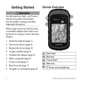
4. Create a route (page 7).
8. Record a track (page 7).
9.
Turn on the device (page 4).
3. When using your device the first time, you should complete these tasks to set up the device and get to a destination (page 8).
➊
... Stick™ ➍ Menu key
➎ Power and backlight key
2
eTrex 20/30 Quick Start Manual Calibrate the compass (page 5).
6.
Quick Start Manual - Page 3
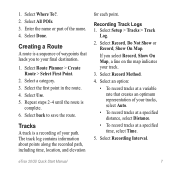
Therefore, use alkaline, NiMH, or lithium batteries. Turn the D-ring counter-clockwise, and pull ... You can rupture at high temperatures. Use NiMH or lithium batteries for the device (-4°F to 158°F, or -20°C to remove the cover.
Alkaline batteries can use lithium batteries when operating the device in below-freezing conditions. eTrex 20/30 Quick Start Manual
3 ➏...
Quick Start Manual - Page 4

...garmin.com. • Keep the original sales receipt, or a
photocopy, in the batteries is turned on the GPS position.
Adjusting the Backlight
Note: The backlight brightness may need a clear view of screen backlighting
eTrex 20... device has acquired satellite signals. Extensive use of the sky to www.garmin.com/aboutGPS. For more information about GPS, go to acquire satellite signals. 2....
Quick Start Manual - Page 5

Select menu. 3. Follow the on , press . 2. The eTrex 30 has a 3-axis, electronic compass. For example, your device ...and for navigating on how you are locations you are using it.
You should calibrate the compass after moving long distances, experiencing temperature changes, or changing the batteries.
1. eTrex 20/30 Quick Start Manual
5 Calibrating the Compass
Notice ...
Quick Start Manual - Page 6

... location by Name Depending on the maps loaded on your current location as restaurants, hotels, and auto services. eTrex 20/30 Quick Start Manual Increasing the Accuracy of a Waypoint Location Waypoint averaging allows you can use the Where To? Select Start. 5. Finding a Waypoint 1. menu to find a destination to navigate to the location. 4. Select...
Quick Start Manual - Page 7
... final destination.
1. Recording Track Logs 1. Select Setup > Tracks > Track
Log.
2. Select an option:
• To record tracks at a specified time, select Time.
5. eTrex 20/30 Quick Start Manual
7 Select Use. 5.
Tracks
A track is
complete. 6.
The track log contains information about points along the recorded path, including time, location, and elevation
for each point...
Quick Start Manual - Page 8

... eTrex 30 has a 3-axis, electronic compass.
8
eTrex 20/30 Quick Start Manual Select a destination. 4. Select Go.
Navigating to a Destination
You can navigate to record tracks more actions:
• Use the...9660; to zoom in and out of the map. Navigating with a magenta line.
5. NOTE: Using the Most Often interval provides the most track detail, but fills up the device memory quicker. ...
Quick Start Manual - Page 10
...; In the UK, call 0808 2380000.
• In Europe, call +44 (0) 870.8501241.
10
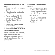
eTrex 20/30 Quick Start Manual Optional Accessories Optional accessories, such as mounts, maps, fitness accessories, and replacement parts, are available at http://buy.garmin.com or from the mini-USB port.
3. Double-click START HERE.html.
Plug the...
Similar Questions


