
Garmin eTrex 20 Support Question
Garmin eTrex 20 Support Question
Find answers below for this question about Garmin eTrex 20.Need a Garmin eTrex 20 manual? We have 2 online manuals for this item!
Question posted by suemri on June 11th, 2014
How Do I Remove Birdseye Sattelite Imagery From My Etrex 30
The person who posted this question about this Garmin product did not include a detailed explanation. Please use the "Request More Information" button to the right if more details would help you to answer this question.
Current Answers
Related Garmin eTrex 20 Manual Pages
Owner's Manual - Page 1

eTrex®
owner's manual
for use with models 10, 20, 30
Owner's Manual - Page 3

........28 Customizing the Main Menu........28 Customizing Specific Pages........28 Profiles 29 System Settings 30 Display Settings 30
3 Menu 11 Routes 12 Tracks 14
Navigation 16 Navigating to a Destination..........16 Map 16 Compass 17 Elevation Plot 19 Trip Computer 20
eTrex Owner's Manual
Table of Contents
Geocaches 21 Downloading Geocaches 21 Filtering the Geocache...
Owner's Manual - Page 10

Using Sight 'N Go
Sight 'N Go is available on the eTrex 30. Select Lock Direction > Project Waypoint.
4. Select Waypoint Averaging.
2.
Select Sight 'N Go.
2....to the object.
1. Enter the distance to the location.
4. Move to the object, and select Done > Save.
10
eTrex Owner's Manual Point the device at an object in the distance, lock in the direction of a location.
3.
Select a...
Owner's Manual - Page 11

.... Additional Maps You can use the Where To? Waypoints, Routes, and Tracks
Finding a Location by Name Depending on the maps loaded on the eTrex 20 and eTrex 30, such as BirdsEye™ satellite imagery, BlueChart® g2, TOPO, and City Navigator® detailed maps. Select Where To? > menu >
Search Near.
2. menu to find a destination to navigate...
Owner's Manual - Page 17

• Select a location on the eTrex 20 and eTrex 30. Navigating a Driving Route Driving route navigation is using the automotive profile, the compass displays GPS heading, not magnetic heading. Select Profile Change > Automotive.
2. Navigation
Compass
The eTrex 30 has a 3-axis, electronic compass.
To improve heading accuracy, do not stand near objects that influence magnetic fields, ...
Owner's Manual - Page 19

... plot, see page 34. Viewing Details about the point appear at the top of the plot.
eTrex Owner's Manual
19 Select Elevation Plot. Select Elevation Plot > menu > Change Plot Type.
2.
between dots on the eTrex 30. Navigating with the course pointer, you can change the pointer setting to display pressure and elevation over...
Owner's Manual - Page 23

...Enable chirp Searching 1. Finding a Geocache with a chirp 1. A chirp is available on the eTrex 30.
Only the owner of the geocache that contains a chirp, details about programming a chirp,....com. Select Geocaches > menu > Show
chirp™ Details.
2.
Select Setup > Geocaches.
2. eTrex Owner's Manual
23 Select chirp™ Searching > On. • To enter a comment about looking...
Owner's Manual - Page 24

... Before you can share information wirelessly.
Select Proximity Alarms.
2. When you enter a proximity alarm area, the device sounds a tone (eTrex 20/30).
24
eTrex Owner's Manual Follow the on-screen instructions. Select a category.
4. Applications
Applications
Sharing Data
The eTrex 30 can share data wirelessly, you must be within a specified range of a compatible Garmin device.
1.
Owner's Manual - Page 34

... destination.
• Compass-switches from an electronic compass to a GPS compass when you turn the device on.
34
eTrex Owner's Manual Customizing Your Device
• Map Datum-sets the ... structured.
• Map Spheroid-shows the coordinate system the device is available on the eTrex 30. Heading Settings
This function is using.
Select Setup > Altimeter.
• Auto Calibration-allows...
Owner's Manual - Page 37

Customizing Your Device
Marine Map Settings
This function is available on the eTrex 20 and eTrex 30.
Simplifies map presentation for optimal use while fishing.
• Appearance-allows ...allows you to select the road type you to set the appearance of bottom contours and depth soundings. eTrex Owner's Manual
37 Select Setup > Marine.
• Marine Chart Mode-allows you want to avoid. ...
Owner's Manual - Page 42

... cause permanent damage.
42
eTrex Owner's Manual Water Immersion
notice The device is not lost when batteries are removed. Device Information
Long-Term ...Storage When you do not plan to wipe dry and air dry the device before using or charging. Stored data is waterproof to IEC Standard 60529 IPX7. After submersion, be certain to use the device for 30...
Owner's Manual - Page 43

... files from BaseCamp™ or HomePort™
Go to remove the cover.
2.
Remove the batteries or battery.
3. File Types The device supports these file types.
• Files from the Garmin POI Loader
• GPX geocache files
Device Information
Installing a microSD Card The eTrex 20 and eTrex 30 can use microSD cards for more information.
1. Turn the...
Owner's Manual - Page 46

.... Select Search for the eTrex 30. or 3 m) of the ANT+ accessory.
2. Customize your device. Before you can purchase additional maps, such as mounts, maps, fitness accessories, and replacement parts, are available for New.
5. Using Optional Fitness Accessories 1. Appendix
Appendix
Optional Accessories
Optional accessories, such as BirdsEye satellite imagery, Garmin custom maps, Inland...
Owner's Manual - Page 53
...to your
mode. dealer. eTrex Owner's Manual
53 I... Garmin
external GPS antenna. I cannot see any new removable drives in ...my list of drives. Appendix
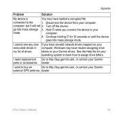
Problem
Solution
My device is
You may have loaded a corrupted file. computer.
4. dealer. connected to assign drive letters. Turn off the device.
go into mass storage mode.
See the Help file for 30...
Owner's Manual - Page 54

...
B backlight
timeout 40 barometer 19 BaseCamp 43 batteries 30, 48
about 41 information 7, 41 installing 7 life 41 long term storage 42 maximizing life 41 selecting the type 7 storage 7 warnings 7 BirdsEye satellite imagery 11 BlueChart g2 maps 11
54
C calculator 25 calendar 25 calibrating
altimeter 20 compass 18 caring for the device 42 long-term...
Owner's Manual - Page 56

...O orientation, map 31
P pages 39
adding 39 removing 39 position format 33 power key 8 profiles 29 ... 52 data 38 device 52 elevation plot 20 restoring default settings 39 routes 12-13 active...26, 47,
49, 52 system settings 30 turning off GPS 26, 27
saving tracks 15
sharing ...30
T text size, maps 32 time
alarms 26 data fields 50 settings 33 sunrise and sunset
25, 50 zone 33 tones 31
56
eTrex Owner...
Quick Start Manual - Page 3
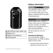
... pull up to 70°C) may exceed the usable range of their capacity as temperature decreases. eTrex 20/30 Quick Start Manual
3 Use NiMH or lithium batteries for the device (-4°F to 158°F, or -20°C to remove the cover.
Installing AA Batteries You can rupture at high temperatures.
➏ ➐
➑ ➒
➏...
Quick Start Manual - Page 5

... changes, or changing the batteries.
1. Select a profile. can be different when you record and store in the device. While the device is on -screen instructions.
eTrex 20/30 Quick Start Manual
5 Follow the on , press . 2.
Waypoints
Waypoints are using the device for geocaching and for navigating on how you are locations you are...
Quick Start Manual - Page 8

... map (page 8) or compass (page 8). Complete one or more or less often.
Select a category. 3. The map page opens with the Bearing Pointer The eTrex 30 has a 3-axis, electronic compass.
8
eTrex 20/30 Quick Start Manual NOTE: Using the Most Often interval provides the most track detail, but fills up the device memory quicker. • Enter...
Quick Start Manual - Page 9

Select Compass.
3. Connect the USB cable to a USB port on Mac computers. Your device and memory card (optional) appear as removable drives in My Computer on Windows
eTrex 20/30 Quick Start Manual
computers and as mounted volumes on your computer.
2.
Begin navigation to a Computer
1. Connecting to a destination (page 8).
2. Sign in that direction to the...
Similar Questions


Garmin Etrex 30 Language
I have an eTrex 30 and the language not open ,could you please let me know what sall i do?
I have an eTrex 30 and the language not open ,could you please let me know what sall i do?
(Posted by mnazari123 10 years ago)

Garmin Etrex 30 Language Change
I accidentally selected the wrong language on initial start up. How do I set English as the language
I accidentally selected the wrong language on initial start up. How do I set English as the language
(Posted by vk3afw 10 years ago)
