
Garmin eTrex 20 Support Question
Garmin eTrex 20 Support Question
Find answers below for this question about Garmin eTrex 20.Need a Garmin eTrex 20 manual? We have 2 online manuals for this item!
Question posted by maxmoKelo on August 18th, 2014
Etrex 20 How To Deleat Geocaches
The person who posted this question about this Garmin product did not include a detailed explanation. Please use the "Request More Information" button to the right if more details would help you to answer this question.
Current Answers
Related Garmin eTrex 20 Manual Pages
Owner's Manual - Page 3

... 12 Tracks 14
Navigation 16 Navigating to a Destination..........16 Map 16 Compass 17 Elevation Plot 19 Trip Computer 20
eTrex Owner's Manual
Table of Contents
Geocaches 21 Downloading Geocaches 21 Filtering the Geocache List..........21 Navigating to a Geocache............22 Logging the Attempt 22 chirp 23
Applications 24 Sharing Data 24 Setting a Proximity Alarm 24 Calculating the...
Owner's Manual - Page 11

...To? > menu >
Search Near.
2. Waypoints, Routes, and Tracks
Finding a Location by Name Depending on the maps loaded on the eTrex 20 and eTrex 30, such as BirdsEye™ satellite imagery, BlueChart® g2, TOPO, and City Navigator® detailed maps. Select menu > ...You can search for cities, geographic points, and various points of the name, and select Done.
eTrex Owner's Manual
11
Owner's Manual - Page 17

... can use the map, you must purchase and load City Navigator maps.
• Select a location on the eTrex 20 and eTrex 30.
Navigating a Driving Route Driving route navigation is using the automotive profile, the compass displays GPS heading, not magnetic heading. You can use a bearing pointer or a course pointer to navigate to the destination...
Owner's Manual - Page 24

... alert you when you enter a proximity alarm area, the device sounds a tone (eTrex 20/30).
24
eTrex Owner's Manual When you are within 10 feet (3 m) of a particular location.
1. Follow the on-screen instructions. Select Create Alarm.
3. Your device can share waypoints, geocaches, routes, and tracks. Select Send or Receive. 3. Applications
Applications
Sharing Data
The...
Owner's Manual - Page 26

...the screen.
3. Turning Off GPS Select Satellite > menu > Use With GPS Off.
26
eTrex Owner's Manual Select Alarm ...Clock. 2. If the device is off at the alarm time, the device turns on at the selected time. Select Turn Alarm On. 4. Changing the Satellite View 1. If necessary, select Track Up to change the view of that satellite (eTrex 20...
Owner's Manual - Page 30

... Geostationary Navigation Overlay Service), or Demo Mode (GPS off . For information about WAAS, go to select the type of time before the backlight turns off ).
Select Setup > Profiles. 2.
Select a profile. 3. Select Setup > Profiles. 2.
Note: To adjust the backlight brightness, see page 40.
• Colors (eTrex 20/30)-sets the colors that display in...
Owner's Manual - Page 33

... track line on your tracks.
eTrex Owner's Manual
33 Position Format Settings
Note: ...GPS position.
Select a measurement type.
3. Customizing Your Device
Time Settings
Select Setup > Time.
• Time Format-allows you to select a 12-hour or a 24-hour display time.
• Time Zone-allows you are saved and cleared automatically based on the user setting.
• Color (eTrex 20...
Owner's Manual - Page 35

...Pressure-records ambient pressure changes over a period of time.
• Calibrate Altimeter-page 20.
• Barometer Mode
◦◦ Variable Elevation-allows the barometer to display the geocache list by names or codes. This can be useful when you are watching for pressure... only due to weather.
• Pressure Trending
◦◦ Save When Power On- eTrex Owner's Manual
35
Owner's Manual - Page 37

...; Fishing-(requires marine maps) displays a detailed view of marine navigation aids on the eTrex 20 and eTrex 30. Customizing Your Device
Marine Map Settings
This function is available on the map. ....
• Appearance-allows you to set the appearance of bottom contours and depth soundings.
eTrex Owner's Manual
37 • Lock On Road-locks the position icon, which represents your ...
Owner's Manual - Page 43

... Turn the D-ring counter-clockwise, and pull up , as instructed in the battery compartment.
➊➋
eTrex Owner's Manual
43 It is not compatible with Mac® OS 10.3 and earlier. Also, some maps ...files from the Garmin POI Loader
• GPX geocache files
Device Information
Installing a microSD Card The eTrex 20 and eTrex 30 can use microSD cards for more information.
1.
Owner's Manual - Page 55

... geocaches 21 software 40 driving routes 37
E editing
profiles 30 routes 12 waypoints 9
eTrex Owner's Manual
elevation plot 19, 20 barometric altimeter 20 ...of a track 15
F file types 43 finding
addresses 12 near your location 11 fishing times 25 fitness options 46
G geocaches 21, 35
downloading 21 filter list 21 logging attempt 22 navigating to 22 settings 35 GPS...
Owner's Manual - Page 56

...16
driving routes 17 to a geocache 22 to waypoints 9 with bearing ... your device 8 resetting
all settings 52 data 38 device 52 elevation plot 20 restoring default settings 39 routes 12-13 active route 13 avoidance 37 creating 12... satellite signals 8, 26, 47,
49, 52 system settings 30 turning off GPS 26, 27
saving tracks 15
sharing data 24 Sight N' Go 10 software
updating...eTrex Owner's Manual
Quick Start Manual - Page 2
... a destination (page 8).
➊
➋
➌
➍
➎
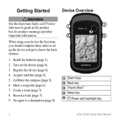
➊ Zoom keys ➋ Back key ➌ Thumb Stick™ ➍ Menu key
➎ Power and backlight key
2
eTrex 20/30 Quick Start Manual
Mark a waypoint (page 6).
7. Install the batteries (page 3).
2.
Quick Start Manual - Page 4

...com/aboutGPS. Satellite Signals
After the device is low.
When the GPS bars on the backlight page (page 4) are set automatically based on , it begins acquiring satellite ...on the GPS position. The device may be limited when the remaining capacity in a safe place.
Adjusting the Backlight
Note: The backlight brightness may need a clear view of screen backlighting
eTrex 20/30 ...
Quick Start Manual - Page 5

... has a 3-axis, electronic compass. eTrex 20/30 Quick Start Manual
5 can be different when you are using it.
Select Compass. 2.
Select Calibrate Compass > Start.
4. Selecting a Profile
Profiles are using the device for geocaching and for navigating on how you record and store in the device. Select a profile.
Select menu. 3.
You should calibrate the...
Quick Start Manual - Page 6

...? Finding a Location by collecting multiple samples of a Waypoint Location Waypoint averaging allows you can search for the waypoint, waiting at least 90 minutes between samples. eTrex 20/30 Quick Start Manual For best results, collect four to eight samples for cities, geographic points, and various points of interest (POIs), such as a waypoint...
Quick Start Manual - Page 7
....
2.
The track log contains information about points along the recorded path, including time, location, and elevation
for each point. If you to save the route. eTrex 20/30 Quick Start Manual
7
Select Record Method.
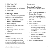
4. Tracks
A track is
complete. 6. Select an option:
• To record tracks at a specified time, select Time.
5. Select All...
Quick Start Manual - Page 8

... map (page 8) or compass (page 8).
Select a destination. 4.
Navigating with your location on , a track log is created. The map page opens with the Bearing Pointer The eTrex 30 has a 3-axis, electronic compass.
8
eTrex 20/30 Quick Start Manual Tip: To customize the map view, select menu > Setup Map, and adjust the settings.
Select Map. 6.
Quick Start Manual - Page 9

...page 8).
2. Connect the USB cable to a USB port on -screen instructions
to find and download geocaches to the destination.
Connect your data or settings.
9 Troubleshooting
Resetting the Device If the device stops ... card (optional) appear as mounted volumes on Windows
eTrex 20/30 Quick Start Manual
computers and as removable drives in . 5.
Downloading Geocaches
1. Go to a Computer
1.
Quick Start Manual - Page 10
... the USA, call (913) 397.8200 or (800) 800.1020.
• In the UK, call 0808 2380000.
• In Europe, call +44 (0) 870.8501241.
10
eTrex 20/30 Quick Start Manual
Plug the small end of the USB cable into the mini-USB port.
4. Open the Garmin\Documents folder or volume.
6.
Connect...
Similar Questions

How Can I Download A Gpsx File (track) Onto My Garmin Etrex 20 Device
Have recently bought an etrex 20 GPS (Live in New Zealand) and would like to down load the "Te Araro...
Have recently bought an etrex 20 GPS (Live in New Zealand) and would like to down load the "Te Araro...
(Posted by helenosephius 8 years ago)


