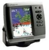
Garmin GPSMAP 545s Support Question
Garmin GPSMAP 545s Support Question
Find answers below for this question about Garmin GPSMAP 545s - Marine GPS Receiver.Need a Garmin GPSMAP 545s manual? We have 4 online manuals for this item!
Question posted by bkrause on August 7th, 2012
Getting The Navigational Chart With Navigational Data
I can't seem to get the standard navigational chart showing the navigation data on a line across the top and bottom of the screen. What I get is the chart with a small black square in the bottom right showing the lat/long and a distance. Is this because the Pan is "on"?
Current Answers
Related Garmin GPSMAP 545s Manual Pages
Quick Reference Guide - Page 1

... want to It
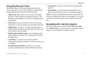
To begin navigating: 1. Finding a Marine Service and Navigating to edit.
3. From the Home screen, select Where To?. 2. Select a category. 3. Select a destination. 4. Select Navigate To. 5.
OR Select Guide To when using a preprogrammed BlueChart® g2 Vision® card to the destination. Follow the colored line on the
Navigation chart and press SELECT.
2. Searching for...
Quick Reference Guide - Page 2

...right, or left or right on the Map The Range (-/+) keys control the zoom level, indicated by the scale at the top of the sonar, to zoom in or out on a chart, to page up , down on the Rocker to switch between modes. Select Navigate....
Home Screen
Please visit www.garmin.com for product warnings and other areas on the unit, the GPS receiver must collect satellite data and establish...
Owner's Manual - Page 3
...8226; Changing the Chart Settings: page 12. • Navigating to select an item, small arrows (>) appear in the text. Introduction
This manual includes information for the following products:
GPSMAP® 430/430s GPSMAP 431/431s GPSMAP 530/530s GPSMAP 531/531s GPSMAP 540/540s GPSMAP 541/541s
GPSMAP 440/440s GPSMAP 441/441s GPSMAP 535/535s GPSMAP 536/536s GPSMAP 545/545s GPSMAP 546/546s
Tips...
Owner's Manual - Page 4
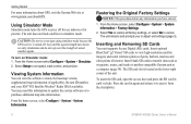
... the Keypad 5 Acquiring GPS Satellite Signals 5 Using Simulator Mode 6 Viewing System Information 6 Restoring the Original Factory Settings 6 Inserting and Removing SD Cards 6 Understanding the Home Screen 7
Using Charts 8 Using the Navigation Chart 8 Changing the Navigation Chart Settings 12 Using the Split Navigation Chart 15 Using Perspective 3D 15
ii
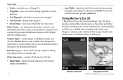
Using Mariner's Eye 3D 16...
Owner's Manual - Page 11
... SELECT MENU HOME
Getting Started
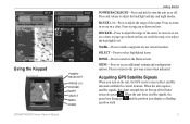
POWER/BACKLIGHT-Press and hold to the Home screen. SELECT-Press to select highlighted items.
HOME-Press to return to turn on or off.
Acquiring GPS Satellite Signals
When you turn the unit on the unit, the GPS receiver must collect satellite data and establish the current location. GPSMAP 400/500 Series...
Owner's Manual - Page 12
...the chartplotter.
GPSMAP 400/500 Series Owner's Manual To turn on the lower-right corner of the ...screen, select Configure > System > System Information > Factory Settings.
2. From the Home screen select Configure > System > Simulator. 2. The unit reboots and prompts you have entered.
1. Using Simulator Mode
Simulator mode turns the GPS receiver off . Insert blank SD cards to transfer data...
Owner's Manual - Page 13

Understanding the Home Screen
Use the Home screen to the Home screen.
• Charts-selects Navigation, Fishing, Perspective 3D, Mariner's Eye 3D, Fish Eye 3D, and Split Navigation charts. Press HOME from MapSource®, update to use a BlueChart g2 Vision SD card. Getting Started
• Sonar-set up and access sonar information (page 50). Note: Mariner's Eye 3D, Fish Eye 3D...
Owner's Manual - Page 14

... for the USA and Bahamas shoreline.
• Navigation Chart-displays all relevant navigation data available on the chart.
• Mariner's Eye 3D-provides a view from above and behind the boat as a navigational aid.
To access a Navigation chart, from the Home screen, select Charts > Navigation Chart. Using Charts
Using Charts
Your chartplotter has a worldwide map and a built...
Owner's Manual - Page 15

...-turn on or off .
GPSMAP 400/500 Series Owner's Manual
Using Charts
Data bars
• Cruising-turn the GPS Speed, GPS Heading, Depth, and GPS Position data bar on the Navigation data bar whenever you are navigating to turn the Depth, Water Temperature, and Water Speed data bar on or off. Full Screen Map-view the Navigation or Fishing chart in fullscreen mode, without...
Owner's Manual - Page 22
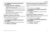
... ones. • New Waypoint-edit, delete, or create a new waypoint. • Active Tracks-manage tracks (page 31). • Saved Tracks-view a list of the course line drawn when navigating. Data Bars (page 9)-show or hide cruising, navigation, fishing, fuel, sailing numbers, or compass tape. Mariner's Eye 3D
Navigation Chart
16
GPSMAP 400/500 Series Owner's Manual
Owner's Manual - Page 23

... and lower to Waypoints & Tracks, Other Vessels, and Data Bars, see "Navigation Chart Menu" on or off . (The Weather feature is only available if the chartplotter is highlighted. 2. The scale ( ) temporarily appears at the bottom of the Mariner's Eye 3D screen, select MENU > Chart Appearance. The Off setting shows the land as beacons, lights, and obstructions: 1. When...
Owner's Manual - Page 27

...?" GPSMAP 400/500 Series Owner's Manual
21 These detailed icons
show the speed and direction of interest (POI) data, ...Chart/Sonar screen to Current-station
display a current graph. See page 43 for instructions on setting up Automatic Guidance for , and navigating to, these POIs, see the "Where To?"
Select Review or the name of the station to view the Navigation chart, Fishing chart, Mariner...
Owner's Manual - Page 31
...g2 Vision data card.
1. GPSMAP 400/500 Series Owner's Manual
25
Select Navigation Chart, Fishing Chart, Perspective 3D, or
Mariner's Eye 3D. 3. Use the Rocker to select an AIS vessel. 4.
Select Navigation Chart, Fishing Chart, Perspective 3D, or Mariner's Eye 3D.
3. From the Home screen, select Charts. 2. Select AIS Vessel > Deactivate.
Select Navigation Chart, Fishing Chart...
Owner's Manual - Page 32
... Note: The Fishing chart and Mariner's Eye 3D are applied to all charts.
1. Select a time. Select MENU > Other Vessels > AIS List.
26
GPSMAP 400/500 Series Owner... or from 500 ft. Select a distance.
4. Select Navigation Chart, Fishing Chart, Perspective 3D, or Mariner's Eye 3D.
3. The safe zone is still labeled as dangerous on the screen.
2. Viewing a List of the safe-zone ring to ...
Owner's Manual - Page 39
... g2 Vision-compatible Garmin GPS units.
Where To?
• Current Data-provides a view of interest (POIs) along the shore. In addition to detailed marine charting, BlueChart g2 Vision has the following features:
• Mariner's Eye 3D-provides a view from the SD card to your computer for a three-dimensional navigation aid (page 16). Navigating with enhanced bottom contours...
Owner's Manual - Page 48
...; Time Zone-set to the next leg.
42
GPSMAP 400/500 Series Owner's Manual
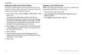
Route Labels-for the Time Zone, the DST option is not available and is structured. Configuring the Chartplotter
Note: You must be receiving NMEA sonar depth data or using a map or chart that specifies a different position format.
Heading-sets the...
Owner's Manual - Page 66

..., refer to turn them on the map. To connect the XM antenna and receiver and for your chartplotter's Navigation chart and other screens throughout the chartplotter.
You might experience a delay before it on a Navigation chart, a Fishing Chart, or a Split Navigation chart:
From the Navigation chart, Fishing chart, or Split Navigation chart, press MENU > Chart Setup > Weather > On.
Owner's Manual - Page 75
...65) cm
30 in. (75 cm)
38 in . Temp. GPSMAP 430/430s GPSMAP 530/530s GPSMAP 540/540s
GPSMAP 440/440s GPSMAP 535/535s GPSMAP 545/545s
High-sensitivity, 14 parallel channel, WAAS-capable receiver.
GPSMAP 431/431s GPSMAP 441/441s GPSMAP 531/531s GPSMAP 541/541s
High-sensitivity, 12 parallel channel, WAAS-capable receiver.
diagonal (10.6 cm), QVGA display with adjustable brightness...
Owner's Manual - Page 76
...times for a stationary receiver with a clear view of the sky.) GPSMAP 430/430s GPSMAP 440/440s GPSMAP 530/530s GPSMAP 535/535s GPSMAP 530/540s GPSMAP 535/545s
Warm:* Approximately 15 seconds Cold:** Approximately 45 seconds
GPSMAP 431/431s GPSMAP 441/441s GPSMAP 531/531s GPSMAP 541/541s
Warm:* Approximately... was turned off, or it has been turned off for more than 2 weeks.
GPS Accuracy: Position:
Owner's Manual - Page 83

... Water Speed 48 Chart/Sonar screen
using 21 chart data 10 charts
detail 14 fish eye 3D 18 fishing 19 mariner's eye 3D 16 navigation 8 settings 12 cleaning the unit 74 Clear User Data 37 collision alarm ...screen, sonar 50 fuse 70
G
gain 54 Garmin Data Transfer 44 gauges, fuel 35 go to 27 GPS 5, 41, 70 Grid (North) 42 guide to 27
H
Hazard Colors 17 heading 42 Heading Line 14 Head Up 13
GPSMAP...
Similar Questions

Garmin 7sv Trouble With Side View
I recently bought a boat that has a Garmin 7sv installed. I took it out for the first time yesterday...
I recently bought a boat that has a Garmin 7sv installed. I took it out for the first time yesterday...
(Posted by jtatkclt 7 years ago)


Remove Some Of The Trails That Are On My Screen
how can I get rid of some of the dotted trails that are left every time I use my navigation map
how can I get rid of some of the dotted trails that are left every time I use my navigation map
(Posted by walterf5 12 years ago)

No Signal From Antenna?
We feel we have wired the entenna int the gpsmap 4012 properly, but we are still not recieving a sig...
We feel we have wired the entenna int the gpsmap 4012 properly, but we are still not recieving a sig...
(Posted by CHRISSHELLY 12 years ago)

Is It Poss To Enter A Manuel Gps Heading To The Garmin Gpsmap545s
(Posted by marioh1228 13 years ago)