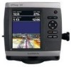
Garmin GPSMAP 541s Support Question
Garmin GPSMAP 541s Support Question
Find answers below for this question about Garmin GPSMAP 541s - Marine GPS Receiver.Need a Garmin GPSMAP 541s manual? We have 8 online manuals for this item!
Question posted by pdstark4 on August 20th, 2011
Compass Rose On The Garmin Gps 541s
how do I shut off the compass rose on the garmin gps 541S ?
Current Answers
Related Garmin GPSMAP 541s Manual Pages
Important Safety and Product Information - Page 2
Battery Warnings
Your GPS unit may use a combination of ...-time clock.
• Do not remove or attempt to this device must accept any interference received, including interference that may damage plastic components. Industry Canada Compliance
note: The following statement does not... DATA INFORMATION: One of the goals of Garmin is waterproof to wipe and air dry the unit before reuse.
Important Safety and Product Information - Page 3
...of the following measures:
• Reorient or relocate the receiving antenna.
• Increase the separation between the equipment and the receiver.
• Connect the equipment into an outlet that ...one year from the GPS unit.
• Consult the dealer or an experienced radio/TV technician for parts or labor, provided that fail in normal use.
Garmin retains the exclusive right ...
Installation Instructions - Page 10

...Compass-Safe Distances:
Model Number
GPSMAP 526/536/546/556 GPSMAP 421/431/441/451 GPSMAP 521/531/541/551 GPSMAP 420/430/440/450 GPSMAP 520/530/540/550/525/535/545/555
Compass... receiver
GPSMAP 421/431/441/451 (s) GPSMAP 521/531/541/551 (s): High-sensitivity 14 parallel channel WAAS-capable receiver.
GPSMAP 526/536/546/556 (s): High-sensitivity 12 parallel channel WAAS-capable receiver....
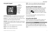
Quick Reference Guide - Page 2

... guide in the product box for additional documentation and information. Home Screen
Please visit www.garmin.com for product warnings and other areas on the chart indicates your manual setting.
To switch... recorded.
© 2009 Garmin Ltd.
To pan the map, press up , down, left or right on the Rocker to turn the unit on the unit, the GPS receiver must collect satellite data and...
Technical Reference for Garmin NMEA 2000 Products - Page 3
... other questions about NMEA 2000-certified Garmin devices, contact Garmin Product Support or a certified NMEA 2000 technician. Technical Reference for the following products: ◦ GPSMAP® 4000/5000/6000/7000 Series chartplotters ◦ GPSMAP 700 Series chartplotters ◦ GPSMAP 4x1/5x1/5x6 Series chartplotters ◦ GMI™ 10 ◦ GPS 17x ◦ GFS™ 10 ◦...
Technical Reference for Garmin NMEA 2000 Products - Page 4
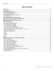
... Thru-Hull)...19 GWS 10 (Garmin Wind Sensor)...20 GHP 10 (Marine Autopilot System)...20 GXM 51...21 VHF 200...21 VHF 300...21 AIS 300...22 AIS 600...22
NMEA 2000-Certified Sensor Configuration Information...23 GPS 17x (GPS Antenna)...23 GFS 10 (Garmin Fuel Sensor)...24 GRA 10 (Garmin Rudder Angle Adapter)...26 GET...
Technical Reference for Garmin NMEA 2000 Products - Page 22
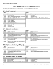
... following tables list the non-proprietary PGN information for Garmin NMEA 2000 Products GPS 17x (GPS Antenna)
Transmit
Receive
059392 060928 126208 126464 126992 126996 129025 129026 129029 ...Receive 059392 059904 060928 126208 127489 127497 127505
127505
Fluid Level (when calibrated using a Garmin chartplotter or marine instrument)
GRA 10 (Garmin Rudder Angle Adapter)
Transmit
Receive...
Technical Reference for Garmin NMEA 2000 Products - Page 28
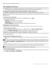
... the Fuel Economy Source The Garmin chartplotter or marine instrument requires a speed sensor, in that fuel tank.
Using Fuel-Level Information With a Garmin Chartplotter or Marine Instrument To receive fuel-level information, connect the... fuel-level sensor of your NMEA 2000 device, select Menu. 2.
Select either GPS Speed or Water Speed to specify which speed sensor is shown on the NMEA 2000...
Owner's Manual - Page 4
... a Destination 28 Creating and Using Waypoints 30 Creating and Using Routes 31 Using Tracks 33 Using BlueChart g2 Vision 34 Navigating with a Garmin Autopilot 35
Viewing Information 36 Viewing a Compass 36 Viewing Numbers 36 Viewing Trip Information 37 Viewing and Customizing Engine Gauges 37 Viewing and Synchronizing Fuel Gauges 40 Viewing and...
Owner's Manual - Page 11
...GPSMAP 400/500 Series Owner's Manual ROCKER-Press to adjust the range of the sonar. Acquiring GPS Satellite Signals
When you turn the unit on lists. When the unit acquires satellite signals, the signal strength bars at www.garmin...mark a waypoint at your current location. Using Simulator Mode
Simulator mode turns the GPS receiver off .
MARK-Press to adjust the range of the sonar, to zoom ...
Owner's Manual - Page 18

... a compass rose around your boat, indicating compass direction. You can view an in the area, select Review, and then select the item.
12
Viewing Tide-Station Information Tide-station information appears on or off . Photos-sets the high-resolution satellite images to a compatible marine wind sensor. Tides/Currents-turns tides and currents on the...
Owner's Manual - Page 19

... top of detail shown on the Rocker to increase map detail.
Press right on the Rocker to decrease map
detail.
GPSMAP 400/500 Series Owner's Manual 13
Wind direction indicator
Compass rose
Press left on the map at different zoom levels.
Sea temperature and fish species can be visible on the Fishing chart...
Owner's Manual - Page 41

...GPSMAP 441/441s, GPSMAP 536/536s, GPSMAP 541/541s, and GPSMAP 546/546s).
Note: You cannot transfer BlueChart g2 Vision data from the SD card to engage the autopilot.
NOTE: Autopilot can be used only with a Garmin...to detailed marine charting, BlueChart g2 Vision has the following features:
• Mariner's Eye... on BlueChart g2 Vision-compatible Garmin GPS units and when using HomePort....
Owner's Manual - Page 65
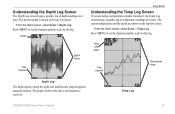
... time. Press MENU to set the duration and the scale for the log. The present depth is received.
Press MENU to the left as information is shown in the top-left corner. Understanding the Depth...left corner. The graph scrolls to set the duration and the scale for the log.
Temp Log
GPSMAP 400/500 Series Owner's Manual
59 From the Home screen, select Sonar > Temp Log. Temp ...
Owner's Manual - Page 91

... water 53 fish 54 fuel 54 GPS accuracy 53 navigation 53 off course 53...19
AIS 27 MARPA 27 fishing information 73
GPSMAP 400/500 Series Owner's Manual 85 Time 49...mariner's eye 3D 16 navigation 8 settings 12 cleaning the unit 82
Clear User Data 44 close hauled wind gauge 42 collision alarm 26 colors, hazard 17 Color Scheme 61 Communications 51 Compass 36 compass rose 12 contact information, Garmin...
Owner's Manual - Page 4
... a Destination 27 Creating and Using Waypoints 29 Creating and Using Routes 30 Using Tracks 31 Using BlueChart g2 Vision 33 Navigating with a Garmin Autopilot 33
Viewing Information 34 Viewing a Compass 34 Viewing Numbers 34 Viewing Trip Information 35 Viewing Fuel Gauges 35 Viewing Tide-station Information 36 Viewing Current Information 36 Viewing...
Owner's Manual - Page 18

...tides and currents on -screen map items, waypoints, and charts. Roses-displays a compass rose around your boat, indicating compass direction.
Photos-sets the high-resolution satellite images to highlight a tide.... GPSMAP 400/500 Series Owner's Manual
Select the item.
High-resolution satellite imagery is connected to a compatible marine wind sensor.
Service Points-turns marine service...
Owner's Manual - Page 19

...: If Weather is
always up and displays various weather parameters, including precipitation (NEXRAD), cloud cover, visibility, WX buoys, and the weather legend.
Wind direction indicator
Compass rose
GPSMAP 400/500 Series Owner's Manual
13 See page 60 for additional information. Orientation-changes the perspective of the map display.
• North Up-sets the...
Owner's Manual - Page 39
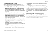
...), if you are prompted to engage the autopilot. The BlueChart g2 Vision Mariner's Eye 3D is more detailed than the preloaded data.
• Fish ... Vision data from above and behind the boat for backup or viewing purposes. GPSMAP 400/500 Series Owner's Manual
33
You can only use the SD card ...Garmin GPS units.
Navigating with enhanced bottom contours and without navigational data.
Owner's Manual - Page 83
...arrival 45 battery 46 clock 46 collision 26, 49 deep water 46 fish 46 fuel 47 GPS accuracy 46 navigation 45 safe-zone 49 shallow water 46 sonar 46 water temp 46 weather ... mariner's eye 3D 16 navigation 8 settings 12 cleaning the unit 74 Clear User Data 37 collision alarm 26, 49 colors, hazard 17 Color Scheme 53 Communications 44 Compass 34 compass rose 12 contact information, Garmin iv
GPSMAP 400...
Similar Questions

How Do I Go Into Simulation Mode On A Garmin Marine Gps Modle741xs
how do I use simulation mode on a garmin 741xs marine ver
how do I use simulation mode on a garmin 741xs marine ver
(Posted by Curthupp 6 years ago)

Gps/map 541s Has No Power
I have tring all conection have their is no power
I have tring all conection have their is no power
(Posted by harrypage 9 years ago)

541s Marine Gps. Depth Not Reading Out.
Depth has been working since installed. Now blank. Is there an on off control for this that may have...
Depth has been working since installed. Now blank. Is there an on off control for this that may have...
(Posted by therad50 11 years ago)

Calibrate Compass On Gps Map 78
when I go to calibrate compass it does not have a calibrate setting in the menu mode
when I go to calibrate compass it does not have a calibrate setting in the menu mode
(Posted by catchhopper 11 years ago)

Transducer
Hello, can i use a thru hull bronze transducer part # 010-10217-00 for a garmin gps 541s? If the anw...
Hello, can i use a thru hull bronze transducer part # 010-10217-00 for a garmin gps 541s? If the anw...
(Posted by danilomedina23 12 years ago)