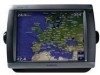
Garmin GPSMAP 5212 Support Question
Garmin GPSMAP 5212 Support Question
Find answers below for this question about Garmin GPSMAP 5212 - Marine GPS Receiver.Need a Garmin GPSMAP 5212 manual? We have 9 online manuals for this item!
Question posted by tkeehan on June 4th, 2014
Shows Wrong Location
I have a Garmin gpsmap 5212. The display shows me in the correct location by landmarks but the gps position numbers are off by quite a bit. I reinstlled the latest firmware update but that didn't seem to help. Whats next?
Current Answers


Related Garmin GPSMAP 5212 Manual Pages
Important Safety and Product Information - Page 3
... and the receiver.
• Connect the equipment into an outlet that fail in accordance with the limits for one of direction, distance, location, or topography.
Within this equipment does cause harmful interference to the customer for parts or labor, provided that the customer shall be made by one year from the GPS unit...
Installation Instructions - Page 1
... specific mounting surface. The size of two ways. Go to the GPS antenna (pages 9-10). 4. August 2009
Part Number 190-00779-02 Rev. In Europe, contact Garmin (Europe) Ltd. Bail Mounting the GPSMAP 4000/5000 Series Chartplotter
Use the included bracket to your Garmin dealer immediately. WARNING: See the Important Safety and Product Information guide...
Installation Instructions - Page 5
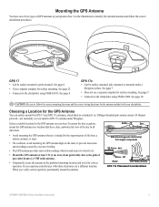
... antenna. Use the illustrations to water level.
See page 10.
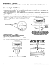
Choosing a Location for the GPS Antenna
You can surface mount the GPS 17 and GPS 17x antennas, attach them to follow the correct installation procedures. OD pipe-threaded-pole marine mount (14 threads- Mounting the GPS Antenna
You have one of two types of any radar beam...
Installation Instructions - Page 6
...to the GPS 17
Align Notch GPSMAP 4000/5000 Series Installation Instructions Attaching the Pole-mount Adapter to the GPS 17: 1.
If you plan to the notch on the selected mounting location.
2....through the larger hole, and apply marine sealant to the base of the additional, larger hole indicated on a standard 1 in .
(4.5
mm)
drill
bit. Align the GPS 17 over the mounting holes, ...
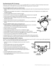
Installation Instructions - Page 7
... of the surface-mount bracket. OD pipe-threaded-pole marine mount (14 threads
per inch-not included) in . (19 mm) drill bit for the cable to the GPS 17x.
7.
OD pipe-threaded-pole marine mount (14 threads-per inch-not included). Select the appropriate drill bit for your chartplotter.
Make sure
that the screw holes...
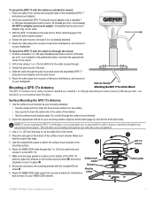
Installation Instructions - Page 8
...GPS 17x antenna
Under-deck mounting bracket
GPSMAP 4000/5000 Series Installation Instructions Pole Mounting the GPS 17x Antenna With the pole-mount adapter attached to the GPS 17x, you want to mount the GPS... 3/4 in. (19 mm) drill bit for the cable to the mounting surface.
5.
To mount the GPS 17x with a marine sealant.
7.
Determine the location on the pole mount, fill the ...
Installation Instructions - Page 9
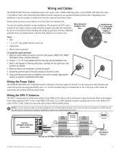
...
4.
The GPS signal is seated. Mark the location where you are provided to weatherproof the cable. Route the cable to the 19-pin NMEA 0183 cable.
Apply a marine sealant around the...one chartplotter to the diagram for the power,
NMEA, Marine Network, or
GPS 17 cable. Use 22 AWG shielded wiring for the boat. Garmin GPSMAP 4000/5000
Series Unit
Power cable
Wire color
Fuse ...
Installation Instructions - Page 12
.... • They will only function in the United States (lower 48). The Garmin Marine Network Cable: • The Garmin Marine Network Cable has a locking ring that can connect a GPSMAP 4000/5000 chartplotter to a Marine Network with a GPSMAP 3000 series chartplotter: • They will share GPS 17 GPS position information as well as to an optional GMS 10 Network Port Expander...
Installation Instructions - Page 14
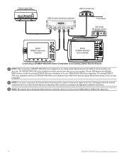
... does not show NMEA 2000 or NMEA 0183 connections.
14
GPSMAP 4000/5000 Series Installation Instructions Note: Every device connected to the Garmin Marine Network must be used but do not share cartography. Garmin marine radar
GSD 22 sounder unit
xxxx
GMS 10 marine network port expander
xxxxxxxxxxxxxxxxxxxxxxx
To transducer
GDL 30/30A XM weather receiver
Garmin GPSMAP 3000 series...
Owner's Manual - Page 11

... (VMG)
data bar on or off . Data Bars-show or hide cruising, navigation, fishing, fuel, or sailing data. Using Charts
Using Charts
Stop Navigation-stop navigating to configure the position of the data on the screen.
• Navigation-turn the GPS Speed, GPS Heading, Depth, and GPS Position data bar on or off . Data bars
•...
Owner's Manual - Page 13
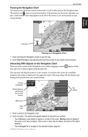
... and bearing from your current position. As you move the cursor, the coordinate location of the pointer is near an object-if the cursor is displayed in the upper-left of... pointer from your present location. If the position icon leaves the map when you touched.
• Touch Review to the selected location (page 8). Touch a point on a Navigation Chart
1. GPSMAP 5000 Series Owner's Manual...
Owner's Manual - Page 43
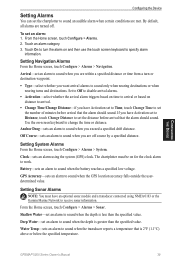
...clock alarm to work.
Clock-sets an alarm using NMEA 0183 or the Garmin Marine Network to receive sonar information. GPS Accuracy-sets an alarm to sound when the battery reaches a specified low ...sets an alarm to sound when the GPS location accuracy falls outside the userdetermined value. From the Home screen, touch Configure > Alarms > Sonar.
GPSMAP 5000 Series Owner's Manual
39 Set to...
Owner's Manual - Page 44
... get the message, contact Garmin Product Support.
40
GPSMAP 5000 Series Owner's Manual
...Marine • Tornado • Severe Storm • Flood • Flash Flood
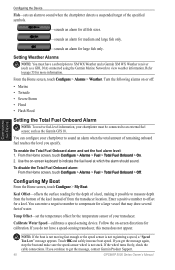
Setting the Total Fuel Onboard Alarm
Note: To receive fuel-level information, your transducer.
From the Home screen, touch Configure > Alarms > Weather.
Enter a positive number to measure depth from the transducer location...
Owner's Manual - Page 45

...positive number
shows depth at the surface.
To customize safe-zone settings: From the Home screen, touch Configure > Other Vessels > Collision Alarm. • Range-change the measured radius of the keel. to 2.0 nm (or from 150 m to 3.0 km, or from the transducer location...
To adjust the Keel Offset: 1. Configuring the Device
GPSMAP 5000 Series Owner's Manual 41 Fuel Capacity-enter the total...
Owner's Manual - Page 59
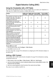
... 0183 network or a NMEA 2000 network. The chartplotter can receive DSC distress and position information from your radio.
Touch DSC to enter the name of the
vessel and then touch Done. 3. Adding a DSC Contact
You can transfer your GPS position to your radio, the chartplotter displays the man-overboard screen and prompts you initiate a man...
Owner's Manual - Page 70

Presets is connected to the Garmin Marine Network and to the audio input of channels that are displayed in the Channel Guide. Channel Guide-selects the ... Weather and Audio
Using XM Audio
When a Garmin XM Audio receiver and antenna is displayed as a category in the category list. Using XM
66
GPSMAP 5000 Series Owner's Manual
Channel display
Channel select
To select an XM Audio Channel:...
Technical Reference for Garmin NMEA 2000 Products - Page 5
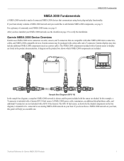
.../backbone cable, and additional T-connectors are listed in the product documentation.
Garmin displays may be connected to add Garmin NMEA 2000 components, see page 8. In this guide will help you ...intended to be packaged with a Garmin GFS 10 fuel sensor. Garmin NMEA 2000 Device Overview
Garmin uses NMEA 2000 micro connectors on the product box shows which NMEA 2000 components are shaded...
Technical Reference for Garmin NMEA 2000 Products - Page 17
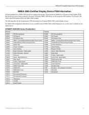
... Water Depth Position - Rapid Update COG & SOG - All the other PGN numbers follow the NMEA 2000 standard. Water Referenced Water Depth Position - NMEA 2000-Compatible Display Device PGN Information
NMEA 2000-Certified Display Device PGN Information
All data transmitted on every available Garmin NMEA 2000-certified display devices, see the owner's manual for Garmin NMEA 2000...
Technical Reference for Garmin NMEA 2000 Products - Page 25
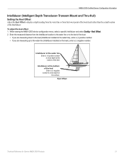
... Intelliducer location to the water line or to the keel of the boat.
• If you are measuring down to the keel (Intelliducer installed at the surface. While viewing the NMEA 2000 device configuration menu, select a specific Intelliducer and select Config > Keel Offset. 2.
Intelliducer at the water line Enter a (+) positive number to show depth...
Technical Reference for Garmin NMEA 2000 Products - Page 26

... a lower number to update the display device less often, and help the gauge needle or wind speed number to specify data for Garmin NMEA 2000 Products
A lower filter setting shows changes in ...the mast of software loaded on your Garmin marine instrument, the specific configuration options may stabilize the display.
A lower filter setting shows changes in the wind speed. To configure...
Similar Questions

Garmin 640 Gps Nmea 0183 Connect To 5212
(Posted by Gerronimo 10 years ago)

I Forgot To Lower My Antenna For Gps Units And The Tops Were Torn Off. Help!
I have a basic GPS and a 5212 unit and both antenna were damaged by low haing branches. The tops wer...
I have a basic GPS and a 5212 unit and both antenna were damaged by low haing branches. The tops wer...
(Posted by DrG5159 10 years ago)

How Do I Get My Garmin 441s To Show My Location
my gps is showing that im in miami while im in turks and caicos
my gps is showing that im in miami while im in turks and caicos
(Posted by bradreece1 11 years ago)

Garmin 5212 Installation Problem
Dear sirs, I tried to get installed one Garmin 5212 unit on my boat and the main unit does not re...
Dear sirs, I tried to get installed one Garmin 5212 unit on my boat and the main unit does not re...
(Posted by coffeecorp2 11 years ago)
My New Gpsmap 740 Displays Inaccurate Gps Heading Information. Cause?
(Posted by Kirkehasson 11 years ago)