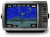
Garmin GPSMAP 4210 Support Question
Garmin GPSMAP 4210 Support Question
Find answers below for this question about Garmin GPSMAP 4210.Need a Garmin GPSMAP 4210 manual? We have 7 online manuals for this item!
Question posted by cmguhm on August 10th, 2014
How To Set The Sonar On A Garmin 4210
The person who posted this question about this Garmin product did not include a detailed explanation. Please use the "Request More Information" button to the right if more details would help you to answer this question.
Current Answers
Related Garmin GPSMAP 4210 Manual Pages
Owner's Manual - Page 2

... may not be viewed and to change or improve its subsidiaries
Garmin International, Inc. 1200 East 151st Street, Olathe, Kansas 66062, USA Tel. (913) 397.8200 or (800) 800.1020 Fax (913) 397.8282
Garmin (Europe) Ltd. Garmin®, the Gamin logo, GPSMAP®, AutoLocate®, MapSource®, BlueChart®, and g2 Vision®...
Owner's Manual - Page 4
...Settings 37 Setting Alarms 38 Setting the Total Fuel Onboard Alarm 39
ii
Configuring My Boat 39 Configuring Other Vessels 40 Configuring XM Audio 41
Using the Marine Network 42 Viewing Connected Garmin Marine...Screen 50 Understanding the Split Frequency Screen..........51 Understanding the Temp Log 51 Setting Up Sonar 52
Digital Selective Calling (DSC 54 Using the Chartplotter with a VHF...
Owner's Manual - Page 8
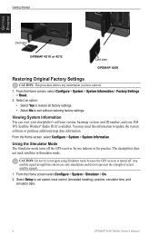
Getting Started
Getting Started
Card label
GPSMAP 4210 or 4212
Card label GPSMAP 4208
Restoring Original Factory Settings
Caution: This procedure deletes any ... set speed, track control (simulated heading), position, simulator time, and
simulator date.
GPSMAP 4000 Series Owner's Manual Select Setup to navigate using Simulator mode because the GPS receiver is turned off the GPS...
Owner's Manual - Page 9
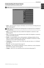
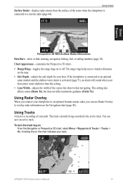
...: Mariner's Eye 3D, Fish Eye 3D, and Fishing Charts are available only if you use a BlueChart g2 Vision SD card.
• Radar-sets up and displays radar (only available if the chartplotter is connected to a radar module) (page 44).
• Sonar-sets up and provides sonar information (only available if the chartplotter is connected to a Garmin sonar...
Owner's Manual - Page 17
...Using Radar Overlay
When you connect your chartplotter to an optional Garmin marine radar, you to overlay radar information on or off.
... to a marine radar (page 44). Using Tracks
A track is the active track. GPSMAP 4000 Series Owner's Manual 13 This setting also affects routes... chartplotter is connected to an optional
sonar module and the shallow water alarm is activated (page ...
Owner's Manual - Page 36
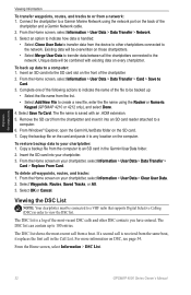
... the Home screen on the computer.
Connect the chartplotter to a Garmin Marine Network using the Rocker or Numeric
Keypad (GPSMAP 4210 or 4212 only), and select Done. 4. Select an option to... of the following actions to a
computer. 6. The file name is a log of the
chartplotter and a Garmin Network cable. 2.
To restore backup data to the network. Copy a backup file from a network: 1....
Owner's Manual - Page 39
...settings. Beeper/Display-set Beeper options, Backlight, and Color mode.
• Beeper-select Beeper to set the chartplotter to a Store Demonstration mode during the initial device setup, this to retrieve data about the marine network. GPS-view GPS..., the chartplotter automatically will be named Demo.)
Auto Power Up (GPSMAP 4210 only)-turn Simulator mode On or Off.
Select Auto to allow the...
Owner's Manual - Page 41

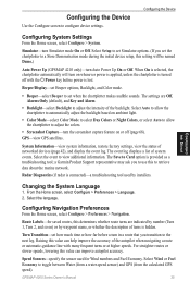
...the Device
GPSMAP 4000 Series Owner's Manual
37 The Auto setting automatically turns ...daylight
saving time on or off, depending on your chartplotter to external NMEA devices, a computer, or other to determine which chartplotter will bridge NMEA 0183 data over the NMEA 2000 bus. See page 67 for the same function. Marine Network-Review all connected Garmin Marine...
Owner's Manual - Page 42
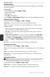
... Home screen, select Configure > Alarms. 2. Anchor Drag-set an alarm to receive sonar information. Clock-sets an alarm using the Garmin Marine Network to sound when the depth is greater than the specified value.
Configuring the Device
38
GPSMAP 4000 Series Owner's Manual Use the Rocker or Numeric Keypad (GPSMAP 4210 or 4212 only) to sound when the...
Owner's Manual - Page 46
.../3006/3010 chartplotter. NOTE: Both the GPS 17 or GPS 17x and any GPSMAP 4000 series chartplotters connected to the Garmin Marine Network and an appropriate transducer. XM WX weather data is shared by all chartplotters on the network. Marine Network
42
GPSMAP 4000 Series Owner's Manual Sonar data is shared by all chartplotters on the network. ◦...
Owner's Manual - Page 47
... to name the device. 5. Use the Rocker or Numeric Keypad (GPSMAP 4210 or 4212 only) to a Garmin Marine Network device: 1. Each connected device is listed along the left side of the screen. Marine Network
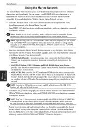
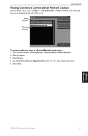
Viewing Connected Garmin Marine Network Devices
From the Home screen, select Configure > Communications > Marine Network. Select Done. From the Home screen, select Configure > Communications...
Owner's Manual - Page 54
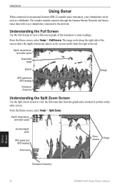
... side of the screen shows the depth of the transducer's sonar readings. The sounder module connects through the Garmin Marine Network and shares sonar data with every chartplotter connected to the network.
Depth, temperature, and water speed
Suspended target
Bottom
Range
GPS speed and GPS heading
Transducer frequency
Understanding the Split Zoom Screen
Use the Split...
Owner's Manual - Page 57
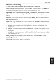
... scale on the right side of the Full screen. Pause Sonar-select to adjust manually, Up or Down). Sonar Setup-open the Sonar Setup screen (page 52). Using Sonar
Advanced Sonar Settings To adjust advanced sonar settings, press MENU while viewing a sonar screen.
GPSMAP 4000 Series Owner's Manual 53
Using Sonar If the screen is off (No Zoom) by default. The...
Owner's Manual - Page 58
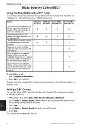
...set up and send individual routine call (page 55). When you to navigate to the man-overboard point (page 55). Select Done. The chartplotter can make calls to a
VHF radio over a NMEA 0183 network or a NMEA 2000 network.
Use the Rocker or Numeric Keypad (GPSMAP 4210... you connect your Garmin VHF radio (page 57). Select DSC to your radio is capable, GPS position information is ...
Owner's Manual - Page 71
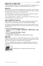
... the GPSMAP 4000 series chartplotter to wire various NMEA 0183-compliant devices, such as depth, speed, water temperature, wind speed and direction, and engine data. Select a setting (Sounder, Route, System, or Garmin). 3....send GPS data to up to enable, the NMEA 0183 output sentence. This chartplotter also includes support for the WPL sentence, DSC, and sonar NMEA 0183 input with GPSMAP 4000 ...
Owner's Manual - Page 79
...3D 6, 15 fishing 6, 15 mariner's eye 6, 15 navigation 6 panning 8 settings 9 using 6 zooming 6 clear user data 32 colors 17 color mode 3 sonar 52 combinations 5, 21 communications settings 37 configure 5, 35 my boat...settings 17 fishing charts 18 fish symbols 52 fronts (weather) 61 FTC 48 fuel gauges 33 full screen 50
G
gain 53 gauges 33
fuel 33 go to 23 GPS... 52
GPSMAP 4000 Series Owner's Manual 75
Technical Reference for Garmin NMEA 2000 Products - Page 13
...Garmin Chartplotter and GPS Antenna
Garmin Chartplotter and GPS Antenna
Garmin Chartplotter Garmin Chartplotter and GPS Antenna Garmin Chartplotter and GPS Antenna Garmin Chartplotter and GPS Antenna Garmin Chartplotter and GPS Antenna Heading Sensor GPS... following table for Garmin NMEA 2000 Products
Refer to the NMEA 2000-certified display devices (such as a GPSMAP 4000/5000 series ...
Technical Reference for Garmin NMEA 2000 Products - Page 14
... Sensor or 130311 - Water Speed])
Either:
• Wind Sensor, a Water Speed Sensor, a Heading Sensor, and a GPS Antenna
• Wind Sensor and a GPS Antenna • Wind Sensor, a Water Speed
Sensor, and a Heading Sensor
(Continued)
10
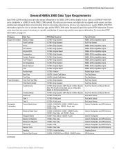
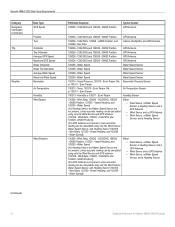
Technical Reference for Garmin NMEA 2000 Products General NMEA 2000 Data Type Requirements
Category Navigation Information (continued)
Trip
Weather...
Technical Reference for Garmin NMEA 2000 Products - Page 15
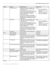
... - GNSS Position, 127250 - Water Speed
(If a Heading Sensor and Water Speed Sensor are not present, a less-accurate reading can be calculated using a GPS antenna instead [129026 - Nav Data
Garmin Chartplotter and GPS Antenna
Maximum Apparent Wind Speed 130306 - COG/SOG, 129029 - COG/SOG, 129029 - Water Speed (If a Water Speed Sensor is not present...
Quick Reference Guide - Page 2
...Numeric Keypad (4010/4210/4012/4212 only)-...the main screens to access advanced settings. • Press and release the...Power key. 2. Select Review > Delete.
Sonar in the USA and other important information. Range...Garmin Ltd. From any time to return to access additional features on the chartplotter: 1. MOB locations are trademarks of Garmin. Garmin®, the Gamin logo, GPSMAP...
Similar Questions

How Do I Go Into Simulation Mode On A Garmin Marine Gps Modle741xs
how do I use simulation mode on a garmin 741xs marine ver
how do I use simulation mode on a garmin 741xs marine ver
(Posted by Curthupp 6 years ago)

My Garmin Gpsmap 4210 Lost The Tracking Feature.
My garmin gpsmap 4210 lost tracking feature when my child played with buttons. How do I get it to tr...
My garmin gpsmap 4210 lost tracking feature when my child played with buttons. How do I get it to tr...
(Posted by Teah137 9 years ago)


How Do I Get The Temp Display On The Screen On My 4210 Garmin
(Posted by bndplumbing 10 years ago)

How Do You Change The Position Settings?
The other day we went out with #s from a local capt the decimal points did not match up and the posi...
The other day we went out with #s from a local capt the decimal points did not match up and the posi...
(Posted by jenn222 11 years ago)