
Garmin GPSMAP 296 Support Question
Garmin GPSMAP 296 Support Question
Find answers below for this question about Garmin GPSMAP 296 - Aviation GPS Receiver.Need a Garmin GPSMAP 296 manual? We have 5 online manuals for this item!
Question posted by emvlad54 on January 14th, 2013
296
Inform me where I can repair the faulty GPS-296.
Current Answers
Related Garmin GPSMAP 296 Manual Pages
Pilot's Guide - Page 3
...MANUAL
The Basic Operation in Marine Mode section provides you with information about navigating with the GPSMAP 296 in Marine Mode, refer to compare the contents of unit features... Garmin GPSMAP® 296, an unsurpassed portable aviation receiver that utilizes the proven performance of Contents. INTRODUCTION
Thank you for reference.
The Introduction contains the Table of Garmin GPS and...
Pilot's Guide - Page 9
... tab down to
the Appendix, page 137, for optional data card
Serial number
GPSMAP 296 Pilot's Guide
1
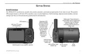
Be sure the antenna is easy to receive satellite signals.
GPS antenna 256-Color TFT screen
with automatically generated turn-by-turn directions.
This portable
GPS navigator features a 256-color TFT screen that is up (as shown here...
Pilot's Guide - Page 12
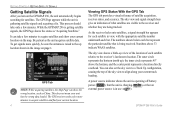
Be patient as China.
The GPS receiver needs a few more quickly, be sure the antenna is raised to the up ), the inner circle represents 45º above 33 indicate WAAS satellites. You can take only a few minutes to the receiver and whether they are being received. GPSMAP 296 Pilot's Guide This process should take a few minutes.
Numbers...
Pilot's Guide - Page 13
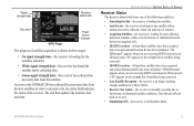
... location, date and time. GPSMAP 296 Pilot's Guide
5 Signal strength bars
Receiver status field
Sky view
GPS Page
Power source indicator
The progress of satellite acquisition is shown in three stages:
• No signal strength bars-the receiver is looking for a 2D or 3D fix.
• Receiver Not Usable-the receiver is in Simulator Mode.
Turn...
Pilot's Guide - Page 14

..., tunnels, and heavy tree cover. The GPS receiver can lose satellite signals due to North Up or Track Up. Monitoring the GPS status is shown on the map.
Press MENU to open the Main Menu. Refer to use your altitude. New Altitude-allows you have traveled more information. GPSMAP 296 Pilot's Guide Any time you to...
Pilot's Guide - Page 19
...
Highlight Setup from the vertical menu. 3. NOTE: Do not attempt to Simulator Mode, the GPS receiver is turned off. When the unit is set to navigate using Simulator Mode.
Press MENU twice...and do not represent the strength of Main Menu
System sub tab
GPSMAP 296 Pilot's Guide
11
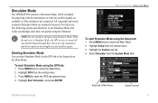
Simulator Mode
The GPSMAP 296 contains a Simulator Mode, which is helpful for future use Simulator...
Pilot's Guide - Page 20
Press MENU to increase or decrease altitude (Aviation Mode only).
12
GPSMAP 296 Pilot's Guide Press MENU twice and highlight GPS from the Panel, Pointer, or Highway pages: 1.
To ... Select Use Identifier from . GETTING STARTED > SIMULATOR MODE
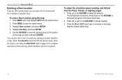
Entering a New Location From the GPS options menu you want, and press ENTER.
You can enter a New Location and New Altitude to page...
Pilot's Guide - Page 21
... can cycle through by pressing PAGE to move forward and QUIT to select Aviation, Automotive, or Marine, and press ENTER.
Use the ROCKER to reverse.
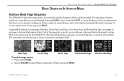
BASIC OPERATION IN AVIATION MODE > AVIATION MODE PAGE SEQUENCE
BASIC OPERATION IN AVIATION MODE
Aviation Mode Page Sequence
The GPSMAP 296 offers three usage modes, Aviation Mode (default), Automotive Mode, and Marine Mode.
Pilot's Guide - Page 30
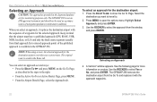
... To Page. See the following page for more
information on the Go To Page, as a primary source of...GPS, RNAV, VOR, NDB, localizer, or ILS) and only the final course segment (usually from the Go To and replaces it replaces the destination airport with the approach waypoints.
22
GPSMAP 296...appears. BASIC OPERATION IN AVIATION MODE > SELECTING AN APPROACH
Selecting an Approach
CAUTION: The...
Pilot's Guide - Page 33
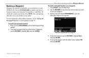
...AVIATION MODE > MARKING A WAYPOINT To mark a selected location as a waypoint 4. Use the ROCKER to move the arrow to the location you record and store in your present location: 1. To mark your GPSMAP 296... GPS tab to view your present location to capture your satellite receiver status.
To accept the waypoint with the default name ("Waypoint"), use the ROCKER to open the
Information ...
Pilot's Guide - Page 43

... the Map Page, and press MENU. 2. From the options menu, highlight Map Information, and
press ENTER. To change data card information: 1.
GPSMAP 296 Pilot's Guide
AVIATION MODE PAGES > MAP PAGE
Individual Map Information Page Showing the individual maps that are shown on your GPSMAP 296 unit and data card. To view the list of maps within a Map Family...
Pilot's Guide - Page 47
... time enroute
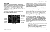
Panel Page
Altitude Vertical speed
CDI scale
AVIATION MODE PAGES > PANEL PAGE
The graphic HSI depicts ...panel instruments use sensors that derived using GPS.
Panel Page
The Panel Page shows GPS-derived data in mind the differences ...provide information different from the center of the CDI to 5.0. GPSMAP 296 Pilot's Guide
39 The Panel Page appears only when the GPSMAP 296 is ...
Pilot's Guide - Page 51

GPSMAP 296 Pilot's Guide
43 Active Route Page
Whenever you start a route (flight plan) or initiate a Go To while in Aviation or Marine Mode, the Active Route ... options in the menu such as a sequence of information. All approach procedures are based on existing GPS, RNAV, VOR, NDB, localizer, or ILS approach procedures. AVIATION MODE PAGES > ACTIVE ROUTE PAGE
Active Route Page...
Pilot's Guide - Page 72

...the screen that shows your routes does not include areas you press ROCKER, the GPSMAP 296 enters pan mode, which moves the map to show any one of the screen shows the GPS status or the route leg. Some items on the Map Page is zoomed ... the options menu for more details about the Map Page. Press MENU to page 28 through 35 in the "Aviation Mode Pages and Features" section for the Map Page.
Pilot's Guide - Page 99
... (DSC) features on the GPSMAP 296. For connection information, refer to transmit a substantial amount of one another. Anytime a vessel receives a DSC call, they are in their VHF radio with the FCC and receive a Maritime Mobile Service Identity (MMSI) number. DSC Page
GPSMAP 296 Pilot's Guide
91 DSC uses marine VHF radio and GPS technologies to transmit position coordinates...
Pilot's Guide - Page 104

...Default. 5.
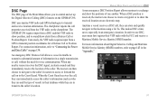
GPS Page
96
GPSMAP 296 Pilot's Guide ...information on the GPS tab is located on page 4. Press MENU to highlight a tab. 3.
The following tabs in previous sections. GPS Tab
The GPS tab provides a visual reference of these pages have already been discussed in-depth in the Main Menu allow you plan trips and use your GPSMAP 296. Some of satellite acquisition, receiver...
Pilot's Guide - Page 109

... an alarm to sound when you want the alarm to sound when the external voltage drops below a specific temperature, or fallen outside of temperatures. GPSMAP 296 Pilot's Guide
101
DGPS-sets an alarm to work . System Alarms Sub Tab
MAIN MENU > ALARMS TAB
Sonar Alarms Sub Tab (Marine Mode Only) You...
Pilot's Guide - Page 124
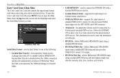
...data and sonar NMEA input support for the DPT, MTW, and VHW sentences.
• Aviation In-the proprietary format used to USB format. This eliminates the need to external devices.
...the input/output format used when connecting your unit to enter the destination on the panel-mounted GPS receiver. Allows the GPSMAP 296 to open the Com 1 and Com 2 sub tab, press MENU twice to show a ...
Pilot's Guide - Page 140

... cm) Transflective, 256-color display with DGPS corrections 0.1 knot RMS steady state 6 g's
132
GPSMAP 296 Pilot's Guide Range: 5°F to 140°F (-15°C to 60°C)
Power Battery: Battery ...receiver
Acquisition Times: Approx. 15 seconds (warm start) Approx. 45 seconds (cold start) Approx. 5 minutes (First Time/AutoLocate®)
Update Rate:
1/second, continuous
Accuracy GPS...
Pilot's Guide - Page 146
... of Defense.
What is receiving WAAS corrections.
138
GPSMAP 296 Pilot's Guide
GPS was originally intended for military applications, but you store in the 1980s, the government made up Differential GPS (DGPS) stations to use . Common GPS Terms Initialize-the first time a GPS receiver orients itself to receive DGPS signals: A beacon receiver compatible with the RTCM format...
Similar Questions

Garmin Gpsmap 296 Battery Recognition
the device will not display a battery level and when powered off it says battery missing. do I need ...
the device will not display a battery level and when powered off it says battery missing. do I need ...
(Posted by robert73571 3 years ago)

Garmin 296 Database Update
how do i update my garmin 296 jeppesen database?
how do i update my garmin 296 jeppesen database?
(Posted by peterhoche 11 years ago)

Availability Of Gps Map 296
Hi: I need GPS MAP 296. Would you plz let me know the availability of the item with quantity. Please...
Hi: I need GPS MAP 296. Would you plz let me know the availability of the item with quantity. Please...
(Posted by shahidanwer76 11 years ago)

How To Connect Gpsmap 296 Pawer/ Data Cable To Serial Port
how to connect garmin data cable to derial port for use on aircraft. which colour code wire will be ...
how to connect garmin data cable to derial port for use on aircraft. which colour code wire will be ...
(Posted by pawanmathur80 12 years ago)

Gps Map 296 Not Locking. In Spite Of It Being Kept On In Clear Sky For 20 Minute
(Posted by nautanurag 12 years ago)