
Garmin GPS 72H Support Question
Garmin GPS 72H Support Question
Find answers below for this question about Garmin GPS 72H.Need a Garmin GPS 72H manual? We have 3 online manuals for this item!
Question posted by chandanhira7 on June 11th, 2014
I Can't Transfer Data From My Gps 72h To Mapsource
what's the problem
Current Answers
Related Garmin GPS 72H Manual Pages
Owner's Manual - Page 5
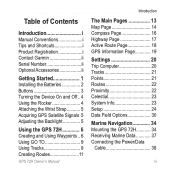
... Highway Page 17 Active Route Page 18 GPS Information Page 19
Settings 20 Trip Computer 20 Tracks 21 Points 21 Routes 22 Proximity 22 Celestial 23 System Info 23 Setup 24 Data Field Options 30
Marine Navigation 34 Mounting the GPS 72H 34 Receiving Marine Data 37 Connecting the Power/Data
Cable 38
GPS 72H Owner's Manual iii
Owner's Manual - Page 8

Stored data is not lost when the batteries are removed. Getting Started
Installing the Batteries
The GPS 72H operates on two AA batteries.
Long-Term Battery Storage Remove the batteries when you do not plan to use the GPS 72H for best results.
Use precharged NiMH or lithium batteries for several months. To install the batteries...
Owner's Manual - Page 9

... to turn the device on or off.
ZOOM IN-press to zoom the map in reverse order. GPS 72H Owner's Manual
Getting Started
ZOOM OUT PAGE
MENU
ENTER/ MARK
ZOOM OUT-press to adjust the backlight....to return to the
previous page and cycle through page items.
PAGE-press to select an menu item, data field, or option. Power-press and hold to a waypoint. Press and hold (man overboard function) to...
Owner's Manual - Page 16
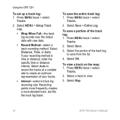
...variable rate to create an optimum representation of the track log: 1. Select Save.
3. Select Map.
10
GPS 72H Owner's Manual
Select the portion of the track log to view.
3. Select a track to save a...8226; Wrap When Full-the track log records over the oldest data with new data.
• Record Method-select a track recording method. Select OK. Using the GPS 72H
To set up a track log: 1.
Owner's Manual - Page 17

...65533;t�o��t�h�e��r�o��u�t�e��.
5. The GPS 72H can store up to automatically create a route. You can have as many as a waypoint.
... waypoints to the route.
6. Press ENTER. Create or modify a route using MapSource® mapping.
Creating Routes
A route is listed as the name of waypoints ...
Owner's Manual - Page 20
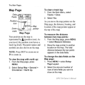
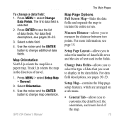
... log: 1. Select Setup Map > General > Orientation > North Up. Move the map pointer to show on the map.
14
GPS 72H Owner's Manual NOTE: Press OUT to zoom out or IN to zoom in the data fields.
As you move the map pointer on the Map page, the distance, bearing, and location of the...
Owner's Manual - Page 21
... and expands the map to include the entire screen.
Measure Distance-allows you to change a data field: 1. For more information, see pages 30-33. The Main Pages
To change additional data fields. GPS 72H Owner's Manual 15 Use the rocker and the ENTER button to customize the detail level, the orientation, and zoom level...
Owner's Manual - Page 22
... Main Pages
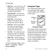
• Map Tab-you can turn on or off MapSource®, customize latitude and longitude grid distance, and customize the grid labels... bearing or course pointer. Choose a bearing pointer or course pointer for the Accuracy Circle and Heading Line. GPS 72H Owner's Manual
Vertical line
Bearing pointer
Compass Page The rotating compass ring indicates the direction you to or course ...
Owner's Manual - Page 23
... the triangle is aligned with the White Line in the data fields.
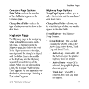
GPS 72H Owner's Manual 17 Change Data Fields-selects the type of data you approach your destination, the message "Arriving at Destination"... navigating when a straight line course can be followed. The Main Pages
Compass Page Options Data Fields-selects the number of the graphic highway does not appear.
◦ Active Route-...
Owner's Manual - Page 25

... status, satellite locations, satellite signal strength, the date, the time and the GPS receiver's current location.
Receiver status
Data fields
Signal strength
Satellite location
Date
Time Location
GPS Information Page
GPS Information Page Options Start/Stop Simulator-enables you have moved the GPS 72H more than 600 miles (1,000 km). To show a specific field, use...
Owner's Manual - Page 26

... indicator
Battery power
Main Menu Page
Trip Computer
For information on the data fields on the main pages and sub-menus. Reset Odometer-resets the Odometer data field to zero. Trip Computer Page
20
GPS 72H Owner's Manual
Reset Trip-resets all data fields except maximum speed and the odometer to zero. Settings
Settings
The...
Owner's Manual - Page 27

... Time, or Distance.
• Interval-selects or enters an interval for the record method.
•
GPS 72H Owner's Manual
Settings
For more information on tracks, see page 9. Tracks
Tracks Options From the Tracks Main... deleted and a new point added at the top of entering a waypoint name in the data field or scrolling through the list. Points
Waypoints are selected and created from the Points page...
Owner's Manual - Page 31
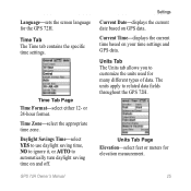
... ignore it, or AUTO to customize the units used for many different types of data. Settings
Current Date-displays the current date based on your time settings and GPS data.
Units Tab Page Elevation-select feet or meters for the GPS 72H.
Language-sets the screen language for elevation measurement. Time Tab Page Time Format...
Owner's Manual - Page 35
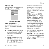
...) appears in an SC-104 format. communication settings between the GPS 72H and other electronic devices. • GARMIN-allows the GPS 72H
to communicate with GARMIN software and other GARMIN GPS devices. • GARMIN DGPS-allows the GPS 72H to accept NMEA data from a device supplying RTCM data in the Baud field. Interface Tab The Interface tab contains two...
Owner's Manual - Page 36

... of the water.
The direction from your starting location to a computer. Settings
• RTCM In/NMEA Out-allows the GPS 72H to acquire data.
30
GPS 72H Owner's Manual
The depth of the device to a destination. Data Field Options
The following table lists all serial communication.
The direction from your current location to output simple text...
Owner's Manual - Page 37

... direction you are traveling.
Data Field Maximum Speed Moving Avg Speed (average) Moving Trip Timer
Off Course
Pointer
Speed
Description
The maximum speed.
ETA at Next (estimated time of arrival)
Estimated time you will reach a GO TO destination or next waypoint.
Elevation
Height above mean sea level (MSL).
GPS 72H Owner's Manual 31...
Owner's Manual - Page 46
... on your computer.
3.
NOTE: For information about MapSource, go to a Computer
1.
Transferring Tracks, Routes, or Waypoints Tracks, routes, and waypoints can be transferred between your connection, press MENU twice > select Setup > Interface > Connected.
Open MapSource on the MapSource Transfer menu.
40
GPS 72H Owner's Manual To transfer tracks, routes, or waypoints to the...
Owner's Manual - Page 52
... data fields 15 full screen 15 measure distance 14 orientation 15 setup page layout 15 zoom scale 14
map pointer 14 MapSource
transferring routes 40 transferring tracks 40 transferring
waypoints 40 marine mount
installing 34-37 marine usage
interfacing 38 NMEA connection
38 MARK button 3 marking a location 6 measuring distance 15 mini-USB 1, 40 MOB button 3
GPS 72H...
Owner's Manual - Page 53

...data cable 38 power button 3, 4 product registration i projecting a waypoint 8 Proximity Alarm 22 proximity list 22
proximity waypoints adding 22 removing 23
R registration i reset max speed 20 resetting GPS 72H 41 reset trip 20 rocker 3, 4 routes
changing name 12 copying 22 creating 11 deleting 22 editing 12 options 22 transferring... 25 format 25 time zone 25 TracBack 11
GPS 72H Owner's Manual 47
Quick Start Manaul - Page 11
... with a USB cable.
2. NOTE: To check your device and a computer using MapSource®. Connect your computer. GPS 72H Quick Start Manual
11
Transferring Tracks, Routes, or Waypoints Tracks, routes, and waypoints can be transferred between your connection, press MENU twice > select Setup > Interface > Connected. Open MapSource on the back of the USB cable to and from...
Similar Questions

Language Conversion In 72h Gps
How to convert languages in 72H Gps ????
How to convert languages in 72H Gps ????
(Posted by ntlonpo 6 years ago)

How To Calculate Area Through Gps 72h?
how to calculate area by gps 72h?
how to calculate area by gps 72h?
(Posted by psanjaypune 10 years ago)

How To Change The English To Persian Language Of Garmin Gps 72h ?
how to change the english to persian language of Garmin GPS 72H ?
how to change the english to persian language of Garmin GPS 72H ?
(Posted by sirussh 11 years ago)

910 Stuck On Transferring Data
How to unstuck my Garmin 910 from transferring data
How to unstuck my Garmin 910 from transferring data
(Posted by Brandon21037 12 years ago)

Transferring Data
Every time I try to transfer my running history from my watch to the computer, it tells me that it h...
Every time I try to transfer my running history from my watch to the computer, it tells me that it h...
(Posted by whitleyhallie 12 years ago)