User Guide
Page 3
...to excessive heat such as outlined in injury or property damage. Do not attempt to determine ground proximity for any interference received, including interference that may cause undesired operation. 3 UL has only tested for Safety [Note-Consider referencing specific UL standard].... This device may not cause harmful interference, and (2) This device must accept any purpose requiring precise measurement of the GPS hardware and GPS operating software. Important Safety Instructions Warning Failure to provide you with route suggestions. UL Certification does not cover the performance...
...to excessive heat such as outlined in injury or property damage. Do not attempt to determine ground proximity for any interference received, including interference that may cause undesired operation. 3 UL has only tested for Safety [Note-Consider referencing specific UL standard].... This device may not cause harmful interference, and (2) This device must accept any purpose requiring precise measurement of the GPS hardware and GPS operating software. Important Safety Instructions Warning Failure to provide you with route suggestions. UL Certification does not cover the performance...
User Guide
Page 10
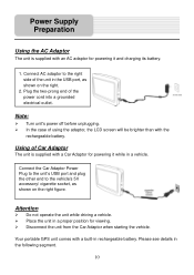
... segment. 10 Power Supply Preparation Using the AC Adaptor The unit is supplied with a Car Adaptor for powering it and charging its battery. 1. Your portable GPS unit comes with the rechargeable battery. Place the unit in a proper position for viewing.
... segment. 10 Power Supply Preparation Using the AC Adaptor The unit is supplied with a Car Adaptor for powering it and charging its battery. 1. Your portable GPS unit comes with the rechargeable battery. Place the unit in a proper position for viewing.
User Guide
Page 11
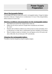
... rechargeable battery The battery must be used and charged when temperatures are between 32°-100°F. Power Supply Preparation About Rechargeable Battery Your portable GPS device comes with a built-in rechargeable battery. When the battery is normally about 2.5 hours of use. Don't put the product on the LCD screen and...
... rechargeable battery The battery must be used and charged when temperatures are between 32°-100°F. Power Supply Preparation About Rechargeable Battery Your portable GPS device comes with a built-in rechargeable battery. When the battery is normally about 2.5 hours of use. Don't put the product on the LCD screen and...
User Guide
Page 21
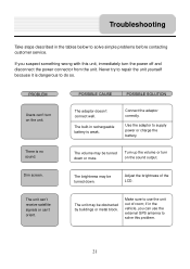
...-in the tables below to solve simple problems before contacting customer service. Connect the adaptor correctly. Make sure to use the external GPS antenna to repair the unit yourself because it is no sound. Never try to solve this unit, immediately turn the power off and...'t connect well. The brightness may be turned down . if in the vehicle, you suspect something wrong with this problem. 21 The unit can't receive satellite signals or can 't turn on the unit. PROBLEM Users can 't orient. Troubleshooting Take steps described in rechargeable battery is weak. There is...
...-in the tables below to solve simple problems before contacting customer service. Connect the adaptor correctly. Make sure to use the external GPS antenna to repair the unit yourself because it is no sound. Never try to solve this unit, immediately turn the power off and...'t connect well. The brightness may be turned down . if in the vehicle, you suspect something wrong with this problem. 21 The unit can't receive satellite signals or can 't turn on the unit. PROBLEM Users can 't orient. Troubleshooting Take steps described in rechargeable battery is weak. There is...
User Manual
Page 2
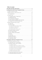
... hidden controls on the map 15 2.3.5 Using the Cursor (the selected map location 18 2.4 Nextar Navigation System concepts 18 2.4.1 Smart Zoom ...18 2.4.2 Position markers 19 2.4.2.1 Current GPS position and Lock-on-Road 19 2.4.2.2 Returning to normal navigation 19 2.4.2.3 Selected location (Cursor...22 2.4.7 Track Logs ...23 2.4.8 Route demonstration 23 2.4.9 POI (Points of Interest 23 2.4.10 Speed limit warning 24 3 Navigating with Nextar Navigation System 25 3.1 Selecting the destination of a route 25 3.1.1 Selecting the Cursor as the destination 25 3.1.2 Entering an address or part...
... hidden controls on the map 15 2.3.5 Using the Cursor (the selected map location 18 2.4 Nextar Navigation System concepts 18 2.4.1 Smart Zoom ...18 2.4.2 Position markers 19 2.4.2.1 Current GPS position and Lock-on-Road 19 2.4.2.2 Returning to normal navigation 19 2.4.2.3 Selected location (Cursor...22 2.4.7 Track Logs ...23 2.4.8 Route demonstration 23 2.4.9 POI (Points of Interest 23 2.4.10 Speed limit warning 24 3 Navigating with Nextar Navigation System 25 3.1 Selecting the destination of a route 25 3.1.1 Selecting the Cursor as the destination 25 3.1.2 Entering an address or part...
User Manual
Page 3
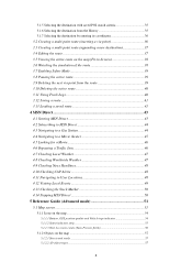
... 4.13 Checking the Stock Market 50 4.14 Stopping MSN Direct 50 5 Reference Guide (Advanced mode 51 5.1 Map screen...51 5.1.1 Icons on the map 54 5.1.1.1 Battery, GPS position quality and Vehicle type indicator 54 5.1.1.2 Status indicator strip 55 5.1.1.3 Next two route events (Turn Preview fields 56 5.1.2 Objects on the map 57 5.1.2.1 Streets...
... 4.13 Checking the Stock Market 50 4.14 Stopping MSN Direct 50 5 Reference Guide (Advanced mode 51 5.1 Map screen...51 5.1.1 Icons on the map 54 5.1.1.1 Battery, GPS position quality and Vehicle type indicator 54 5.1.1.2 Status indicator strip 55 5.1.1.3 Next two route events (Turn Preview fields 56 5.1.2 Objects on the map 57 5.1.2.1 Streets...
User Manual
Page 4
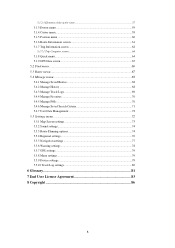
......59 5.1.5 Position menu ...60 5.1.6 Route Information screen 61 5.1.7 Trip Information screen 62 5.1.7.1 Trip Computer screen 64 5.1.8 Quick menu...64 5.1.9 GPS Data screen 65 5.2 Find menu ...66 5.3 Route menu...67 5.4 Manage menu 68 5.4.1 Manage Saved Routes 68 5.4.2 Manage History 68 5.4.3 Manage... Sound settings...74 5.5.3 Route Planning options 74 5.5.4 Regional settings 76 5.5.5 Navigation settings 77 5.5.6 Warning settings 78 5.5.7 GPS settings...79 5.5.8 Menu settings...79 5.5.9 Device settings 79 5.5.10 Track Log settings 80 6 Glossary 81 7 End User License Agreement 83 8 ...
......59 5.1.5 Position menu ...60 5.1.6 Route Information screen 61 5.1.7 Trip Information screen 62 5.1.7.1 Trip Computer screen 64 5.1.8 Quick menu...64 5.1.9 GPS Data screen 65 5.2 Find menu ...66 5.3 Route menu...67 5.4 Manage menu 68 5.4.1 Manage Saved Routes 68 5.4.2 Manage History 68 5.4.3 Manage... Sound settings...74 5.5.3 Route Planning options 74 5.5.4 Regional settings 76 5.5.5 Navigation settings 77 5.5.6 Warning settings 78 5.5.7 GPS settings...79 5.5.8 Menu settings...79 5.5.9 Device settings 79 5.5.10 Track Log settings 80 6 Glossary 81 7 End User License Agreement 83 8 ...
User Manual
Page 5
... road geometry. Never place Nextar Q4-MD where it obstructs the driver's view, where it is a navigation system that Nextar Navigation System recommended, Nextar Navigation System changes the instructions accordingly. others cannot track you deviate from the route that helps you start your destination with its built-in GPS receiver. Unless only passengers operate Nextar Navigation System, we...
... road geometry. Never place Nextar Q4-MD where it obstructs the driver's view, where it is a navigation system that Nextar Navigation System recommended, Nextar Navigation System changes the instructions accordingly. others cannot track you deviate from the route that helps you start your destination with its built-in GPS receiver. Unless only passengers operate Nextar Navigation System, we...
User Manual
Page 11
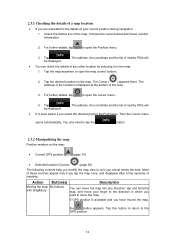
... Manipulating the map Position markers on the map. Tap this button to return to open the map control buttons. 2. Tap the map anywhere to the GPS position. 12 The address of the map. 3. Then the Cursor menu opens automatically. For further details, tap to open the Position menu. 3. The... Most of these controls appear only if you tap the map once, and disappear after a few seconds of your actual needs the best. If GPS position is available and you have moved the map, the button appears. It shows the current street and house number information. 2. 2.3.1 Checking the...
... Manipulating the map Position markers on the map. Tap this button to return to open the map control buttons. 2. Tap the map anywhere to the GPS position. 12 The address of the map. 3. Then the Cursor menu opens automatically. For further details, tap to open the Position menu. 3. The... Most of these controls appear only if you tap the map once, and disappear after a few seconds of your actual needs the best. If GPS position is available and you have moved the map, the button appears. It shows the current street and house number information. 2. 2.3.1 Checking the...
User Manual
Page 12
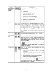
... and you have rotated the map, Viewing modes the button appears. If GPS position is displayed on the screen. , Nextar Navigation System uses high-quality vector maps that you need to tap it to switch to GPS position button • Smart Zoom button Zooming in 3D mode, you see...map at various zoom levels, always with optimized content. It always displays street names and other text with these buttons. When GPS position is available, Nextar Navigation System always rotates the map so its top faces your direction of the map is available and you 13 Changes the ...
... and you have rotated the map, Viewing modes the button appears. If GPS position is displayed on the screen. , Nextar Navigation System uses high-quality vector maps that you need to tap it to switch to GPS position button • Smart Zoom button Zooming in 3D mode, you see...map at various zoom levels, always with optimized content. It always displays street names and other text with these buttons. When GPS position is available, Nextar Navigation System always rotates the map so its top faces your direction of the map is available and you 13 Changes the ...
User Manual
Page 13
... you can display it in its full length on the map. • Track Information screen: A track log can be modified in the map data, Nextar Navigation System displays the lanes and their directions using small arrows either at the bottom or at the top of the map (the position of... your maneuver at the next junction. • If the next turn is at a distance, Nextar Navigation System zooms out and lowers the view angle to the current GPS position. Returning to normal navigation (back to the GPS position with automatic map rotation) Zoom preset buttons (available in Advanced mode only) Tap this...
... you can display it in its full length on the map. • Track Information screen: A track log can be modified in the map data, Nextar Navigation System displays the lanes and their directions using small arrows either at the bottom or at the top of the map (the position of... your maneuver at the next junction. • If the next turn is at a distance, Nextar Navigation System zooms out and lowers the view angle to the current GPS position. Returning to normal navigation (back to the GPS position with automatic map rotation) Zoom preset buttons (available in Advanced mode only) Tap this...

User Manual
Page 14
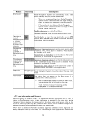
... automatic off-route recalculation is switched off, and you is no valid GPS position, Tap this area to open the Route Information screen. navigate the recommended route. the view of the road the lane leads to make Nextar Navigation System recalculate the recommended route. Some dots need to turn green ...to be taken; Tap this area to . If the icon is animated, Nextar Navigation System is in the top left corner, the Turn Preview field. This area gives you tap route calculation is Nothing happens if you...
... automatic off-route recalculation is switched off, and you is no valid GPS position, Tap this area to open the Route Information screen. navigate the recommended route. the view of the road the lane leads to make Nextar Navigation System recalculate the recommended route. Some dots need to turn green ...to be taken; Tap this area to . If the icon is animated, Nextar Navigation System is in the top left corner, the Turn Preview field. This area gives you tap route calculation is Nothing happens if you...
User Manual
Page 15
... 0% and 100%. Track Log recording Nothing happens if you this area of the upcoming intersection is shown here if there is muted. Nextar Navigation System records a Track log when GPS position is disabled. There are both available, this field shows the route event Tap this area simulation. Icon Information Details Action There...
... 0% and 100%. Track Log recording Nothing happens if you this area of the upcoming intersection is shown here if there is muted. Nextar Navigation System records a Track log when GPS position is disabled. There are both available, this field shows the route event Tap this area simulation. Icon Information Details Action There...

User Manual
Page 16
...: • Current speed • Speed limit on the current road Time information There are time values that can be shown: • Current GPS time • Time remaining to reach the destination • Time remaining to reach the next via point • Estimated arrival time at the destination...these three fields. The battery is being Vehicle type The symbol displays the vehicle type used for More information GPS position quality A higher number of lit bars indicates better GPS position accuracy. Tap this area to be shown in the three data fields shown on the map screen. ...
...: • Current speed • Speed limit on the current road Time information There are time values that can be shown: • Current GPS time • Time remaining to reach the destination • Time remaining to reach the next via point • Estimated arrival time at the destination...these three fields. The battery is being Vehicle type The symbol displays the vehicle type used for More information GPS position quality A higher number of lit bars indicates better GPS position accuracy. Tap this area to be shown in the three data fields shown on the map screen. ...
User Manual
Page 17
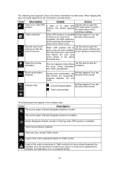
... zoom feature: • While following options: • Use the Find menu to select a location. Choose the one of the following a route calculated by Nextar Navigation System: when approaching a turn is at a distance, it will zoom in the middle, and the Cursor menu appears with the name, address and coordinate... can perform the following actions: Button Action In the active route, uses the Cursor as the start point by replacing the current GPS position (available in Advanced mode only) In the active route, uses the Cursor as the destination by the available routing methods.
... zoom feature: • While following options: • Use the Find menu to select a location. Choose the one of the following a route calculated by Nextar Navigation System: when approaching a turn is at a distance, it will zoom in the middle, and the Cursor menu appears with the name, address and coordinate... can perform the following actions: Button Action In the active route, uses the Cursor as the start point by replacing the current GPS position (available in Advanced mode only) In the active route, uses the Cursor as the destination by the available routing methods.
User Manual
Page 18
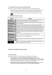
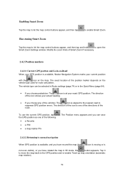
...If you choose any of the vehicles: The icon is one of Smart Zoom if necessary. 2.4.2 Position markers 2.4.2.1 Current GPS position and Lock-on-Road When your GPS position is at your current position with the icon on the vehicle type used for route calculation. Tap it to move the... heading. • If you choose pedestrian: The icon is available, Nextar Navigation System marks your exact GPS position. The direction of the position marker depends on the map. To use the current GPS position, tap the GPS position as one of the directions of the icon is aligned to the...
...If you choose any of the vehicles: The icon is one of Smart Zoom if necessary. 2.4.2 Position markers 2.4.2.1 Current GPS position and Lock-on-Road When your GPS position is at your current position with the icon on the vehicle type used for route calculation. Tap it to move the... heading. • If you choose pedestrian: The icon is available, Nextar Navigation System marks your exact GPS position. The direction of the position marker depends on the map. To use the current GPS position, tap the GPS position as one of the directions of the icon is aligned to the...
User Manual
Page 19
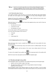
...of a route • a via point in a route • the destination of the Cursor menu initiate actions for large objects to your current GPS position. 2.4.2.3 Selected location (Cursor) If you select a location in the background of the screen low. The map jumps back to the position with... dot ( ) to make it visible at the selected point on the current time and GPS 20 Nextar Navigation System displays the Cursor with icon appears again. 2.4.3 Daytime and night color profiles Nextar Navigation System uses different color profiles during the day and during the night. • Daytime...
...of a route • a via point in a route • the destination of the Cursor menu initiate actions for large objects to your current GPS position. 2.4.2.3 Selected location (Cursor) If you select a location in the background of the screen low. The map jumps back to the position with... dot ( ) to make it visible at the selected point on the current time and GPS 20 Nextar Navigation System displays the Cursor with icon appears again. 2.4.3 Daytime and night color profiles Nextar Navigation System uses different color profiles during the day and during the night. • Daytime...
User Manual
Page 22
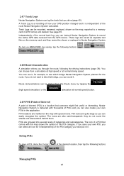
... Route demonstration A simulation drives you through the route, following buttons: . The icons are quite large so you have put it . 2.4.7 Track Logs Nextar Navigation System can log the track that someone might find useful or interesting. You can choose from a simulation at high speed or at the desired... the map with the map shows the symbol of a POI that bridge, you can also create your GPS position changed and it , for example, to record the native GPS data received from the Route menu by tapping the (high speed simulation) or the (simulation at normal speed) button...
... Route demonstration A simulation drives you through the route, following buttons: . The icons are quite large so you have put it . 2.4.7 Track Logs Nextar Navigation System can log the track that someone might find useful or interesting. You can choose from a simulation at high speed or at the desired... the map with the map shows the symbol of a POI that bridge, you can also create your GPS position changed and it , for example, to record the native GPS data received from the Route menu by tapping the (high speed simulation) or the (simulation at normal speed) button...
User Manual
Page 24
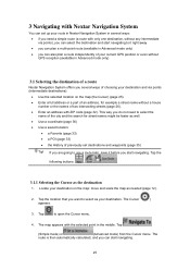
... streets (page 26). • Enter an address with the selected point in Advanced mode only) 3.1 Selecting the destination of a route Nextar Navigation System offers you several ways of choosing your destination and via points), you can select the destination and start navigating to it before ... if you need to use a route later, save it right away • you can also plan a route independently of your current GPS position or even without GPS reception (available in the middle. Locate your destination. The map appears with ZIP code (page 32). Tap to select as the destination...
... streets (page 26). • Enter an address with the selected point in Advanced mode only) 3.1 Selecting the destination of a route Nextar Navigation System offers you several ways of choosing your destination and via points), you can select the destination and start navigating to it before ... if you need to use a route later, save it right away • you can also plan a route independently of your current GPS position or even without GPS reception (available in the middle. Locate your destination. The map appears with ZIP code (page 32). Tap to select as the destination...
User Manual
Page 33
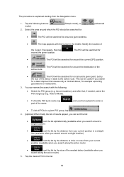
... of the detour it adds to the active route. The POI will be searched for • : The POI will be searched for around the current GPS position. • : The POI will be searched for around the given location. . The procedure is explained starting from your current position in the middle. Accommodation...
... of the detour it adds to the active route. The POI will be searched for • : The POI will be searched for around the current GPS position. • : The POI will be searched for around the given location. . The procedure is explained starting from your current position in the middle. Accommodation...


