
Quick Reference Guide
Page 2
... format. • Provide street routing capabilities (when a street routing data map has been uploaded). • Load and save waypoints, routes and tracks in eXporist Introduction 1 Installation 2 First Time Use 3 format with an .imi extension. Supported GPS Receivers • eXplorist 210 • eXplorist 400 / 500 / 600 • eXplorist XL Introduction Note: Magellan MapSend Lite does not support...
... format. • Provide street routing capabilities (when a street routing data map has been uploaded). • Load and save waypoints, routes and tracks in eXporist Introduction 1 Installation 2 First Time Use 3 format with an .imi extension. Supported GPS Receivers • eXplorist 210 • eXplorist 400 / 500 / 600 • eXplorist XL Introduction Note: Magellan MapSend Lite does not support...
Quick Reference Guide
Page 6
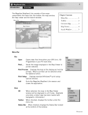
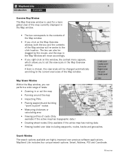
...of five major components; the menu bar, the toolbar, the map window, the map viewer and the search window. Exit Ends the Magellan MapSend Lite session and closes the application. Overview Print... 4 Introduction Overview The Magellan MapSend Lite consists of the window. What is printed can be ...the map on the display as it will be selected under the menu bar. Menu Bar Toolbar Map Viewer Overview Map Chapter Contents: Menu Bar 1 Toolbar 2 Overview Map 3 Map Viewer 4 Search Window 5 Search Window Menu Bar File Open Opens data files from either your GPS ...
...of five major components; the menu bar, the toolbar, the map window, the map viewer and the search window. Exit Ends the Magellan MapSend Lite session and closes the application. Overview Print... 4 Introduction Overview The Magellan MapSend Lite consists of the window. What is printed can be ...the map on the display as it will be selected under the menu bar. Menu Bar Toolbar Map Viewer Overview Map Chapter Contents: Menu Bar 1 Toolbar 2 Overview Map 3 Map Viewer 4 Search Window 5 Search Window Menu Bar File Open Opens data files from either your GPS ...
Quick Reference Guide
Page 7
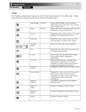
...Magellan formats. Search Displays the Search window. Locate Used to GPX (GPS eXchange) file format. You can be used to convert data between selected points. This provides a way of a track or route. File Manager Used to transfer data between PC and a GPS receiver and to move the map in the Map... Viewer window. Zoom Selects the zoom cursor to GPX... GPS Contents Map Manager Opens a Map Manager window accessing maps saved on the full screen. Street Routes This is a drop down menu that ...
...Magellan formats. Search Displays the Search window. Locate Used to GPX (GPS eXchange) file format. You can be used to convert data between selected points. This provides a way of a track or route. File Manager Used to transfer data between PC and a GPS receiver and to move the map in the Map... Viewer window. Zoom Selects the zoom cursor to GPX... GPS Contents Map Manager Opens a Map Manager window accessing maps saved on the full screen. Street Routes This is a drop down menu that ...
Quick Reference Guide
Page 8
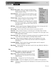
Show Topo When checked topographic details will be displayed next to select the units of Magellan GPS device that are connected to the PC. About Displays an About window with the application (eXplorist or Meridian/SporTrak). Overview POI Properties Displays a POI window... window is being used (true north or magnetic) for the map in the Map Viewer window. GPS Settings Used to select the north reference used with information on using the application. Check for Update Checks the Magellan web site for the map (WGS 84, NAD 83 or NAD 27 CONUS). North Reference Used to ...
Show Topo When checked topographic details will be displayed next to select the units of Magellan GPS device that are connected to the PC. About Displays an About window with the application (eXplorist or Meridian/SporTrak). Overview POI Properties Displays a POI window... window is being used (true north or magnetic) for the map in the Map Viewer window. GPS Settings Used to select the north reference used with information on using the application. Check for Update Checks the Magellan web site for the map (WGS 84, NAD 83 or NAD 27 CONUS). North Reference Used to ...
Quick Reference Guide
Page 9
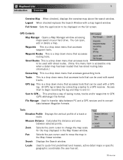
...files from either your GPS Unit, SD Programmer or your hard drive. Selects the zoom cursor to zoom out on the map displayed in the Menu Bar. Displays the Waypoint Control Center. Quick tool to set scale of the functions found in the Map Viewer window. Displays the... as they will be the most common functions used. Map Manager Cntl+M Open Zoom In Cntl+O Zoom Out Set Map Scale Pan Locate 3-D View Elevation Profile Street Routes Measure Distance Waypoint Viewer Waypoint Routes Search Opens a Map Manager window displaying maps saved on your PC hard drive. You can open...
...files from either your GPS Unit, SD Programmer or your hard drive. Selects the zoom cursor to zoom out on the map displayed in the Menu Bar. Displays the Waypoint Control Center. Quick tool to set scale of the functions found in the Map Viewer window. Displays the... as they will be the most common functions used. Map Manager Cntl+M Open Zoom In Cntl+O Zoom Out Set Map Scale Pan Locate 3-D View Elevation Profile Street Routes Measure Distance Waypoint Viewer Waypoint Routes Search Opens a Map Manager window displaying maps saved on your PC hard drive. You can open...
Quick Reference Guide
Page 10
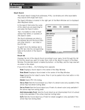
...8226; If you click on this window, the context menu appears, which allows you to set the view scale in the Map Overview window. MapSend Lite includes four unique search options: Smart, Address, POI and Coordinate. Search Window The search options available are highly improved over...8226; Placing waypoints and building "point-to the current view scale of roads (Only available if the active map has topographic data.) • Creating street routes (Only available if the active map has routing data. • Viewing loaded user data including waypoints, routes, tracks and geocaches. The box ...
...8226; If you click on this window, the context menu appears, which allows you to set the view scale in the Map Overview window. MapSend Lite includes four unique search options: Smart, Address, POI and Coordinate. Search Window The search options available are highly improved over...8226; Placing waypoints and building "point-to the current view scale of roads (Only available if the active map has topographic data.) • Creating street routes (Only available if the active map has routing data. • Viewing loaded user data including waypoints, routes, tracks and geocaches. The box ...
Quick Reference Guide
Page 11
... MapSend starts. The found POIs and other searchable map objects with single text input. Result list Displays the list of the objects found object as a Start of the Search dialog. View Street Displays a found street in the Address tab and the found addresses are listed in the center of a street route... Point Sets the found object as a Finish of the Main Window and is better to your query. are searching for street navigation (only available if the active map has routing data). Set as Start Sets the found object as a Finish for and press the Search button. Then it...
... MapSend starts. The found POIs and other searchable map objects with single text input. Result list Displays the list of the objects found object as a Start of the Search dialog. View Street Displays a found street in the Address tab and the found addresses are listed in the center of a street route... Point Sets the found object as a Finish of the Main Window and is better to your query. are searching for street navigation (only available if the active map has routing data). Set as Start Sets the found object as a Finish for and press the Search button. Then it...
Quick Reference Guide
Page 12
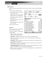
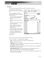
...code (if known). Press the Search button. If you click on the map. Fill in the center of the street. City: Type or insert a name of a house (if known). State: Type or insert a name of the Map Window. Displays a found object in the search address fields: House: Type...Sets the found object as an Intermediate Point of a street route (only available if the active map has routing data). View Street - Copies the full object's name. Sets the found object as a Finish of a street route (only available if the active map has street routing data). Add Intermediate Point - Copy - Sets...
...code (if known). Press the Search button. If you click on the map. Fill in the center of the street. City: Type or insert a name of a house (if known). State: Type or insert a name of the Map Window. Displays a found object in the search address fields: House: Type...Sets the found object as an Intermediate Point of a street route (only available if the active map has routing data). View Street - Copies the full object's name. Sets the found object as a Finish of a street route (only available if the active map has street routing data). Add Intermediate Point - Copy - Sets...
Quick Reference Guide
Page 13
...on More... Displays found object as an Intermediate Point of a street route (only available if the active map has routing data). Sets the found object as a Finish of a street route (only available if the active map has routing data). Sets the found object as a Finish for ...GoTo - the following menu appears: View - Opens POI Info dialog. From the On Map list-box choose Background Map or Detailed Map. If you are searching for street navigation (only available if the active map has routing data). Within a Distance of a desired radius. From the Search criterion list...
...on More... Displays found object as an Intermediate Point of a street route (only available if the active map has routing data). Sets the found object as a Finish of a street route (only available if the active map has routing data). Sets the found object as a Finish for ...GoTo - the following menu appears: View - Opens POI Info dialog. From the On Map list-box choose Background Map or Detailed Map. If you are searching for street navigation (only available if the active map has routing data). Within a Distance of a desired radius. From the Search criterion list...


