User Manual
Page 3
Table of Contents Introduction 1 Conventions Used in this Manual 1 GPS 315/320 Receiver 2 Getting Started 3 Receiver Accuracy 3 Installing the Batteries 3 Proper Handling - Signal Reception 4 Power On 4 Initialize 4 Initialize for First Time Use 4 Selecting Primary Usage 5 Getting a Fixed Position 6 Saving Your Waypoint 6 Basic Operation 7 Entering Information 7 Navigation Screens 7 Using the Status Screen 8 Using the Position...
Table of Contents Introduction 1 Conventions Used in this Manual 1 GPS 315/320 Receiver 2 Getting Started 3 Receiver Accuracy 3 Installing the Batteries 3 Proper Handling - Signal Reception 4 Power On 4 Initialize 4 Initialize for First Time Use 4 Selecting Primary Usage 5 Getting a Fixed Position 6 Saving Your Waypoint 6 Basic Operation 7 Entering Information 7 Navigation Screens 7 Using the Status Screen 8 Using the Position...
User Manual
Page 4
... Screen 20 Selecting Time Format 20 Resetting Elapsed Time 21 Reference 22 Working with Waypoints 23 Creating a User Waypoint 24 Editing a User Waypoint 24 Creating/Editing/Deleting a Message in a User Waypoint 25 Saving Changes to a Selected Waypoint . 25 Projecting a Waypoint 25 Sorting a Waypoint 26 Deleting a User Waypoint 26 Finding a Non-UserWaypoint 26 DataSend™ CD (optional 27 ii
... Screen 20 Selecting Time Format 20 Resetting Elapsed Time 21 Reference 22 Working with Waypoints 23 Creating a User Waypoint 24 Editing a User Waypoint 24 Creating/Editing/Deleting a Message in a User Waypoint 25 Saving Changes to a Selected Waypoint . 25 Projecting a Waypoint 25 Sorting a Waypoint 26 Deleting a User Waypoint 26 Finding a Non-UserWaypoint 26 DataSend™ CD (optional 27 ii

User Manual
Page 5
... Board Route .......... 29 Creating a Backtrack Route 29 Creating a Multi-Leg Route 30 Viewing/Editing a Route 31 Inserting a Leg 31 Changing a Waypoint in a Route ..... 31 Adding a Waypoint at the End of a Route 32 Deleting a Waypoint in a Route ........ 32 Saving a Route 32 Activating/Deactivating a Route ....... 32 Reversing a Route 33 Using Plot View in a Route 33...
... Board Route .......... 29 Creating a Backtrack Route 29 Creating a Multi-Leg Route 30 Viewing/Editing a Route 31 Inserting a Leg 31 Changing a Waypoint in a Route ..... 31 Adding a Waypoint at the End of a Route 32 Deleting a Waypoint in a Route ........ 32 Saving a Route 32 Activating/Deactivating a Route ....... 32 Reversing a Route 33 Using Plot View in a Route 33...
User Manual
Page 9
... quickly, the manual is to get you navigate using waypoints, routes and auxiliary functions. The GPS 320 has a database of worldwide cities as well as it prepares your purchase of these items are also subchapters that the GPS 315 has a database of worldwide cities consisting of the world... is designed to be unfamiliar to establish options you . It is divided into the "Great Outdoors" rather than wordy sentences. Magellan GPS 315/GPS 320 1 Introduction Congratulations on the box. The Basic Operation chapter describes the features found in this Manual The manual is very ...
... quickly, the manual is to get you navigate using waypoints, routes and auxiliary functions. The GPS 320 has a database of worldwide cities as well as it prepares your purchase of these items are also subchapters that the GPS 315 has a database of worldwide cities consisting of the world... is designed to be unfamiliar to establish options you . It is divided into the "Great Outdoors" rather than wordy sentences. Magellan GPS 315/GPS 320 1 Introduction Congratulations on the box. The Basic Operation chapter describes the features found in this Manual The manual is very ...
User Manual
Page 10
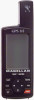
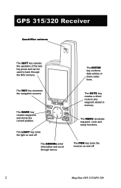
... . 2 Magellan GPS 315/GPS 320 The MARK key creates waypoints and stores the current position. The GOTO key creates a direct route to back through menus. GPS 315/320 Receiver Quadrifilar antenna The QUIT key cancels the operation of the last key press and can be used to any waypoint stored in memory.... The NAV key accesses the navigation screens. The MENU accesses waypoint, route and setup functions. The...
... . 2 Magellan GPS 315/GPS 320 The MARK key creates waypoints and stores the current position. The GOTO key creates a direct route to back through menus. GPS 315/320 Receiver Quadrifilar antenna The QUIT key cancels the operation of the last key press and can be used to any waypoint stored in memory.... The NAV key accesses the navigation screens. The MENU accesses waypoint, route and setup functions. The...
User Manual
Page 13
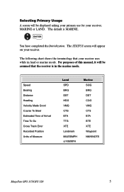
... BRG DST HDG VMG CTS ETA TTG XTE Landmark MILES/MPH or KM/KPH Marine SOG BRG DST COG VMG CTS ETA ETE XTE Waypoint NM/KNOTS Magellan GPS 315/GPS 320 5 The following chart shows the terminology that the receiver is MARINE. Speed Bearing Distance Heading Velocity Made Good Course To Steer Estimated Time...
... BRG DST HDG VMG CTS ETA TTG XTE Landmark MILES/MPH or KM/KPH Marine SOG BRG DST COG VMG CTS ETA ETE XTE Waypoint NM/KNOTS Magellan GPS 315/GPS 320 5 The following chart shows the terminology that the receiver is MARINE. Speed Bearing Distance Heading Velocity Made Good Course To Steer Estimated Time...
User Manual
Page 14
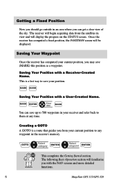
... your position. GOTO Select category ENTER Select waypoint ENTER This completes the Getting Started section. Saving Your Waypoint Once the receiver has computed your current position, you with the NAV screens and more detailed functions. 6 Magellan GPS 315/GPS 320 This is a route that guides you... from your current position to any time. Saving Your Position with a User-Created Name. MARK ENTER Enter data MARK You can save (MARK) this position as a waypoint. The following Basic Operation...
... your position. GOTO Select category ENTER Select waypoint ENTER This completes the Getting Started section. Saving Your Waypoint Once the receiver has computed your current position, you with the NAV screens and more detailed functions. 6 Magellan GPS 315/GPS 320 This is a route that guides you... from your current position to any time. Saving Your Position with a User-Created Name. MARK ENTER Enter data MARK You can save (MARK) this position as a waypoint. The following Basic Operation...
User Manual
Page 21
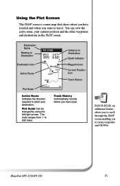
... traveled and where you want to reach your current position and the other waypoints and destination in the PLOT screen. PAN-N-SCAN, an additional feature, allows you to scroll through the PLOT screen enabling you to 200 miles. Magellan GPS 315/GPS 320 13 Destination Name Bearing to Destination Destination Icon Active Route Plot Scale...
... traveled and where you want to reach your current position and the other waypoints and destination in the PLOT screen. PAN-N-SCAN, an additional feature, allows you to scroll through the PLOT screen enabling you to 200 miles. Magellan GPS 315/GPS 320 13 Destination Name Bearing to Destination Destination Icon Active Route Plot Scale...
User Manual
Page 22
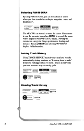
... "dropping bread crumbs" from your starting point as you travel. If the cursor is over a waypoint brings up the name, bearing and distance. Moving the cursor over the waypoint icon when MENU is useful when you want to return to move the cursor. Setting Track History ...HISTORY records where you have traveled according to waypoints, routes and track history. From PLOT screen MENU Select TRACK HIST ENTER Change field ENTER Clearing Track History From PLOT MENU Select screen CLR TRACK ENTER Select ENTER 14 Magellan GPS 315/GPS 320 Selecting PAN-N-SCAN By using PAN-N-SCAN,...
... "dropping bread crumbs" from your starting point as you travel. If the cursor is over a waypoint brings up the name, bearing and distance. Moving the cursor over the waypoint icon when MENU is useful when you want to return to move the cursor. Setting Track History ...HISTORY records where you have traveled according to waypoints, routes and track history. From PLOT screen MENU Select TRACK HIST ENTER Change field ENTER Clearing Track History From PLOT MENU Select screen CLR TRACK ENTER Select ENTER 14 Magellan GPS 315/GPS 320 Selecting PAN-N-SCAN By using PAN-N-SCAN,...
User Manual
Page 24
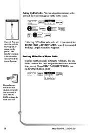
... SHOW DATA to appear on the plotter screen. PWLPOTTNSACMAELSES OFF 0.1 ON 0.2 0.3 0.5 0.8 1 2 3 5 8 10 20 50 100 200 Figure A. You may select the scale for a waypoint. You can turn the scales off . If you select either hide these fields on which has been selected previously, you can set up the maximum...will be hidden. Under HIDE DATA/SHOW DATA, you may want bearing and distance to be prompted to change the plot scales for the waypoint to bring the fields into view. 16 Magellan GPS 315/GPS 320 Setting Up Plot Scales. The number you will appear.
... SHOW DATA to appear on the plotter screen. PWLPOTTNSACMAELSES OFF 0.1 ON 0.2 0.3 0.5 0.8 1 2 3 5 8 10 20 50 100 200 Figure A. You may select the scale for a waypoint. You can turn the scales off . If you select either hide these fields on which has been selected previously, you can set up the maximum...will be hidden. Under HIDE DATA/SHOW DATA, you may want bearing and distance to be prompted to change the plot scales for the waypoint to bring the fields into view. 16 Magellan GPS 315/GPS 320 Setting Up Plot Scales. The number you will appear.
User Manual
Page 30
...edit or delete any one of waypoints. You can be reset to establish the options you navigate using your receiver. As stated earlier in the uses of the 20 routes. The Auxiliary Function section tells you in the user manual, the GPS 315 has a database of worldwide ...or can create your receiver. 22 Magellan GPS 315/GPS 320 Following, you how to select the Sun/Moon and Fish/Hunt options, contrast, simulate mode and the alarms and message functions. The receiver holds 20 routes with Waypoints section tells you will cover waypoints, routes, and auxiliary functions. Now...
...edit or delete any one of waypoints. You can be reset to establish the options you navigate using your receiver. As stated earlier in the uses of the 20 routes. The Auxiliary Function section tells you in the user manual, the GPS 315 has a database of worldwide ...or can create your receiver. 22 Magellan GPS 315/GPS 320 Following, you how to select the Sun/Moon and Fish/Hunt options, contrast, simulate mode and the alarms and message functions. The receiver holds 20 routes with Waypoints section tells you will cover waypoints, routes, and auxiliary functions. Now...
User Manual
Page 31
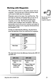
... DataSend™ CD. You can store up to edit, delete, project and sort waypoints. GPS 315 Worldwide major cities Worldwide large, medium and small cities GPS 320 Worldwide major cities Regional large and medium cities Regional buoys, lighthouses and fixed navaids Magellan GPS 315/GPS 320 23 The User types are permanently stored in the receiver's memory. WPT...
... DataSend™ CD. You can store up to edit, delete, project and sort waypoints. GPS 315 Worldwide major cities Worldwide large, medium and small cities GPS 320 Worldwide major cities Regional large and medium cities Regional buoys, lighthouses and fixed navaids Magellan GPS 315/GPS 320 23 The User types are permanently stored in the receiver's memory. WPT...
User Manual
Page 32
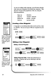
... WPT SORT WPT DELETE WPT PROJECTION WAYPOINTS ROUTES SETUP SUN/MOON FISH/HUNT CONTRAST ALARM/MSG Figure A. From any of the city using the following to edit the desired fields. B Select data field ENTER Make changes ENTER 24 Magellan GPS 315/GPS 320 This division is a recorded ...position that the cities (non-user waypoints) are working with waypoints, you will notice that can be edited. You can be used in a route or a...
... WPT SORT WPT DELETE WPT PROJECTION WAYPOINTS ROUTES SETUP SUN/MOON FISH/HUNT CONTRAST ALARM/MSG Figure A. From any of the city using the following to edit the desired fields. B Select data field ENTER Make changes ENTER 24 Magellan GPS 315/GPS 320 This division is a recorded ...position that the cities (non-user waypoints) are working with waypoints, you will notice that can be edited. You can be used in a route or a...
User Manual
Page 33
...change any NAV screen Select MENU WAYPOINTS ENTER Select category ENTER Select waypoint ENTER MENU Select PROJECT ENTER FIG. Magellan GPS 315/GPS 320 25 Select CLEAR MSG ENTER Saving Changes to create a waypoint at a certain distance and direction from an existing waypoint. BRG/DST BRG 000˚... MSG SAVE EDITS To delete a message. Follow the instructions on selecting a waypoint. C ENTER Projecting a Waypoint This function allows you can change the data fields shown in a User Waypoint To create a message. D Select field ENTER Make changes ENTER MARK You ...
...change any NAV screen Select MENU WAYPOINTS ENTER Select category ENTER Select waypoint ENTER MENU Select PROJECT ENTER FIG. Magellan GPS 315/GPS 320 25 Select CLEAR MSG ENTER Saving Changes to create a waypoint at a certain distance and direction from an existing waypoint. BRG/DST BRG 000˚... MSG SAVE EDITS To delete a message. Follow the instructions on selecting a waypoint. C ENTER Projecting a Waypoint This function allows you can change the data fields shown in a User Waypoint To create a message. D Select field ENTER Make changes ENTER MARK You ...
User Manual
Page 34
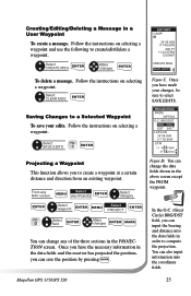
... may find the second letter, "O". From any NAV screen Select MENU WAYPOINTS ENTER Select category ENTER MENU ENTER Find waypoint Select FIND 26 Magellan GPS 315/GPS 320 Then use . From any NAV screen Select MENU WAYPOINTS ENTER Select category ENTER Select waypoint MENU Select ENTER DELETE WPT FIG. WPT SORT ALPHABETIC NEAREST ICON/NAME Figure A. YES NO...
... may find the second letter, "O". From any NAV screen Select MENU WAYPOINTS ENTER Select category ENTER MENU ENTER Find waypoint Select FIND 26 Magellan GPS 315/GPS 320 Then use . From any NAV screen Select MENU WAYPOINTS ENTER Select category ENTER Select waypoint MENU Select ENTER DELETE WPT FIG. WPT SORT ALPHABETIC NEAREST ICON/NAME Figure A. YES NO...

User Manual
Page 35
... came with the receiver can be restored at any time. The software allows you enter. The list of waypoints selected in the specified geographic area can zoom in the receiver. Magellan GPS 315/GPS 320 27 While running DataSend™ you will compute the amount of memory required and whether your selection fits into your...
... came with the receiver can be restored at any time. The software allows you enter. The list of waypoints selected in the specified geographic area can zoom in the receiver. Magellan GPS 315/GPS 320 27 While running DataSend™ you will compute the amount of memory required and whether your selection fits into your...
User Manual
Page 36
No matter where you go, you can save a waypoint at the top of the screen. 28 Magellan GPS 315/GPS 320 While on the plotter screen. As an example, you will not be displayed in the MENU. By selecting the GOTO destination waypoint from your home. The CLEAR GOTO function allows you can be able to delete...
No matter where you go, you can save a waypoint at the top of the screen. 28 Magellan GPS 315/GPS 320 While on the plotter screen. As an example, you will not be displayed in the MENU. By selecting the GOTO destination waypoint from your home. The CLEAR GOTO function allows you can be able to delete...
User Manual
Page 37
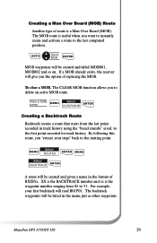
...Another type of route is the waypoint number ranging from the last point recorded in track history using the "bread crumbs" saved, to the first point recorded for track history. If a MOB already exists, the receiver will read B01P01. Magellan GPS 315/GPS 320 29 While in MOB ...screen MENU Select CLEAR MOB ENTER Creating a Backtrack Route Backtrack creates a route that starts from 01 to 31. GOTO Select MOB ENTER MOB waypoints will be created and titled MOB001, MOB002 and so...
...Another type of route is the waypoint number ranging from the last point recorded in track history using the "bread crumbs" saved, to the first point recorded for track history. If a MOB already exists, the receiver will read B01P01. Magellan GPS 315/GPS 320 29 While in MOB ...screen MENU Select CLEAR MOB ENTER Creating a Backtrack Route Backtrack creates a route that starts from 01 to 31. GOTO Select MOB ENTER MOB waypoints will be created and titled MOB001, MOB002 and so...
User Manual
Page 38
... navaids with your home, to a campsite and then to a favorite fishing spot, you can combine waypoints of the world. 30 Magellan GPS 315/GPS 320 Continue this menu as an option for your route. A ENTER Select * category ENTER Select waypoint ENTER * You can create a route that would take you to each place. Use this process until...
... navaids with your home, to a campsite and then to a favorite fishing spot, you can combine waypoints of the world. 30 Magellan GPS 315/GPS 320 Continue this menu as an option for your route. A ENTER Select * category ENTER Select waypoint ENTER * You can create a route that would take you to each place. Use this process until...

User Manual
Page 39
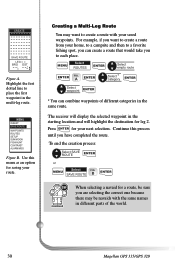
...your home to edit Select VIEW/EDIT FIG. route D Select waypoint MENU MENU ACTIVATE VIEW/EDIT REVERSE DELETE BACKTRACK PLOT VIEW WAYPOINTS ROUTES SETUP SUN/MOON FISH/HUNT CONTRAST ALARM/MSG Figure C. You can add the waypoint for the stream to the campsite and not stop at the ... Viewing/Editing a Route MENU MENU Select ROUTES ENTER Select route to a campsite, you can replace the stream waypoint with the fishing spot. Select category ENTER Select waypoint ENTER Magellan GPS 315/GPS 320 31 You can add to stop at on the way to your home to campsite route, you want...
...your home to edit Select VIEW/EDIT FIG. route D Select waypoint MENU MENU ACTIVATE VIEW/EDIT REVERSE DELETE BACKTRACK PLOT VIEW WAYPOINTS ROUTES SETUP SUN/MOON FISH/HUNT CONTRAST ALARM/MSG Figure C. You can add the waypoint for the stream to the campsite and not stop at the ... Viewing/Editing a Route MENU MENU Select ROUTES ENTER Select route to a campsite, you can replace the stream waypoint with the fishing spot. Select category ENTER Select waypoint ENTER Magellan GPS 315/GPS 320 31 You can add to stop at on the way to your home to campsite route, you want...


