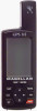
User Manual
Page 4
... Resetting the Trip Odometer 19 Setting the Speed Average 19 Using the Time Screen 20 Selecting Time Format 20 Resetting Elapsed Time 21 Reference 22 Working with Waypoints 23 Creating a User Waypoint 24 Editing a User Waypoint 24 Creating/Editing/Deleting a Message in a User Waypoint 25 Saving Changes to a Selected Waypoint . 25...
... Resetting the Trip Odometer 19 Setting the Speed Average 19 Using the Time Screen 20 Selecting Time Format 20 Resetting Elapsed Time 21 Reference 22 Working with Waypoints 23 Creating a User Waypoint 24 Editing a User Waypoint 24 Creating/Editing/Deleting a Message in a User Waypoint 25 Saving Changes to a Selected Waypoint . 25...

User Manual
Page 5
Using DataSend 27 Working with Routes 28 Creating/Clearing a GOTO 28 Creating a GOTO on the Plotter Screen ... 28 Creating a Man Over Board Route .......... 29 Creating a Backtrack Route 29 Creating a ... in a Route ........ 32 Saving a Route 32 Activating/Deactivating a Route ....... 32 Reversing a Route 33 Using Plot View in a Route 33 Deleting a Route 33 Working with TrackRoute 34 Auxiliary Functions 35 Working with Sun/Moon and Fish/Hunt .. 35 Selecting the Simulate Mode 36 Selecting Contrast 36 Selecting Alarm/Message 37 Accessing the Alarm...
Using DataSend 27 Working with Routes 28 Creating/Clearing a GOTO 28 Creating a GOTO on the Plotter Screen ... 28 Creating a Man Over Board Route .......... 29 Creating a Backtrack Route 29 Creating a ... in a Route ........ 32 Saving a Route 32 Activating/Deactivating a Route ....... 32 Reversing a Route 33 Using Plot View in a Route 33 Deleting a Route 33 Working with TrackRoute 34 Auxiliary Functions 35 Working with Sun/Moon and Fish/Hunt .. 35 Selecting the Simulate Mode 36 Selecting Contrast 36 Selecting Alarm/Message 37 Accessing the Alarm...
User Manual
Page 30
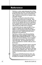
... user positions which can be reset to build routes for three different regions of defaults. As stated earlier in the receiver's memory. The Working with 30 legs. You can be used to the alarm default settings or can create your own waypoints (known as User waypoints) or ... you in the receiver's memory (NonUser waypoints). The receiver holds 20 routes with Routes section tells you navigate using your receiver. 22 Magellan GPS 315/GPS 320 The Reference section will help you of the four different types of routes consisting of cities and marine navaids for navigation.
... user positions which can be reset to build routes for three different regions of defaults. As stated earlier in the receiver's memory. The Working with 30 legs. You can be used to the alarm default settings or can create your own waypoints (known as User waypoints) or ... you in the receiver's memory (NonUser waypoints). The receiver holds 20 routes with Routes section tells you navigate using your receiver. 22 Magellan GPS 315/GPS 320 The Reference section will help you of the four different types of routes consisting of cities and marine navaids for navigation.
User Manual
Page 31
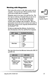
.... Working with Waypoints This section tells you how to 500 user positions which can edit and delete these waypoints, if you wish. GPS 315 Worldwide major cities Worldwide large, medium and small cities GPS 320 Worldwide major cities Regional large and medium cities Regional buoys, lighthouses and fixed navaids Magellan GPS 315/GPS 320...User types display locations, their coordinates and a description. To help you understand the difference, the chart below shows the differences between the GPS 315 and GPS 320. The User types are permanently stored in the receiver's memory.
.... Working with Waypoints This section tells you how to 500 user positions which can edit and delete these waypoints, if you wish. GPS 315 Worldwide major cities Worldwide large, medium and small cities GPS 320 Worldwide major cities Regional large and medium cities Regional buoys, lighthouses and fixed navaids Magellan GPS 315/GPS 320...User types display locations, their coordinates and a description. To help you understand the difference, the chart below shows the differences between the GPS 315 and GPS 320. The User types are permanently stored in the receiver's memory.
User Manual
Page 32
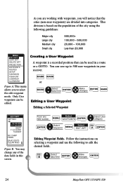
...this screen. From any of the city using the following to edit the desired fields. B Select data field ENTER Make changes ENTER 24 Magellan GPS 315/GPS 320 Only User waypoints can be used in a route or a GOTO. You can be edited. Follow the instructions on the population ...23:35PM 12JUN97 NO CAMP FIRES SAVE EDITS CLEAR MSG Figure B. This division is a recorded position that the cities (non-user waypoints) are working with waypoints, you to select the edit waypoint mode. Creating a User Waypoint A waypoint is based on selecting a waypoint and use the following...
...this screen. From any of the city using the following to edit the desired fields. B Select data field ENTER Make changes ENTER 24 Magellan GPS 315/GPS 320 Only User waypoints can be used in a route or a GOTO. You can be edited. Follow the instructions on the population ...23:35PM 12JUN97 NO CAMP FIRES SAVE EDITS CLEAR MSG Figure B. This division is a recorded position that the cities (non-user waypoints) are working with waypoints, you to select the edit waypoint mode. Creating a User Waypoint A waypoint is based on selecting a waypoint and use the following...
User Manual
Page 36
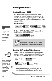
...Clearing a GOTO A GOTO is a route that guides you from the plotter screen, you can save a waypoint at the top of the screen. 28 Magellan GPS 315/GPS 320 As an example, you can be created by selecting a waypoint on the plotter screen, follow this procedure to navigate back home by using GOTO.... A GOTO route can avoid selecting the wrong waypoint if its name is displayed at your current position to delete an active GOTO route. Working with another waypoint. GOTO MENU Select ENTER CLEAR GOTO If there are no When the crosshair is over the waypoint icon, the waypoint name...
...Clearing a GOTO A GOTO is a route that guides you from the plotter screen, you can save a waypoint at the top of the screen. 28 Magellan GPS 315/GPS 320 As an example, you can be created by selecting a waypoint on the plotter screen, follow this procedure to navigate back home by using GOTO.... A GOTO route can avoid selecting the wrong waypoint if its name is displayed at your current position to delete an active GOTO route. Working with another waypoint. GOTO MENU Select ENTER CLEAR GOTO If there are no When the crosshair is over the waypoint icon, the waypoint name...
User Manual
Page 42
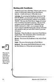
Working with the receiver and pass individual track points, the legs will indicate TO: LEGXXXX where XXXX is between 0 to skip 1 or more of track points ... other causing the receiver to 1200. Backtrack. As you navigate with TrackRoute TrackRoute (previously called Map 'N Track in the receiver) consists of these legs. 34 Magellan GPS 315/GPS 320 A track can navigate from overwriting track points in size. By activating the TrackRoute at the top of the navigation screens will switch and countdown...
Working with the receiver and pass individual track points, the legs will indicate TO: LEGXXXX where XXXX is between 0 to skip 1 or more of track points ... other causing the receiver to 1200. Backtrack. As you navigate with TrackRoute TrackRoute (previously called Map 'N Track in the receiver) consists of these legs. 34 Magellan GPS 315/GPS 320 A track can navigate from overwriting track points in size. By activating the TrackRoute at the top of the navigation screens will switch and countdown...
User Manual
Page 43
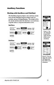
You can change the location (AT) and/or the date (ON) for the calculation. Magellan GPS 315/GPS 320 35 Sun/Moon From any NAV screen MENU Select FISH/HUNT ENTER FIG. Auxiliary Functions Working with Sun/Moon and Fish/Hunt The Sun/Moon function displays solar and lunar calculations and the Fish/Hunt function displays...
You can change the location (AT) and/or the date (ON) for the calculation. Magellan GPS 315/GPS 320 35 Sun/Moon From any NAV screen MENU Select FISH/HUNT ENTER FIG. Auxiliary Functions Working with Sun/Moon and Fish/Hunt The Sun/Moon function displays solar and lunar calculations and the Fish/Hunt function displays...
User Manual
Page 44
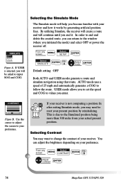
... a position fix after exiting Simulate mode, you will help you initiated the mode) and select OFF or power the receiver off. B Adjust contrast ENTER 36 Magellan GPS 315/GPS 320 Selecting Contrast You may need to follow the route. You can return to change the contrast of 25 mph and automatically generates a COG to... window (where you become familiar with your actual present position. Selecting the Simulate Mode The Simulate mode will be asked to values you end it works by reinitializing.
... a position fix after exiting Simulate mode, you will help you initiated the mode) and select OFF or power the receiver off. B Adjust contrast ENTER 36 Magellan GPS 315/GPS 320 Selecting Contrast You may need to follow the route. You can return to change the contrast of 25 mph and automatically generates a COG to... window (where you become familiar with your actual present position. Selecting the Simulate Mode The Simulate mode will be asked to values you end it works by reinitializing.
User Manual
Page 58
... daylight savings time? No. Why is diminished. You say my receiver should work up to enter coordinates that you have the display backlight on NiCad batteries, the battery life is the time and date incorrect after tracking a satellite. 50 Magellan GPS 315/GPS 320 The receiver will be two reasons. Can I use of the year...
... daylight savings time? No. Why is diminished. You say my receiver should work up to enter coordinates that you have the display backlight on NiCad batteries, the battery life is the time and date incorrect after tracking a satellite. 50 Magellan GPS 315/GPS 320 The receiver will be two reasons. Can I use of the year...