
Garmin eTrex 20 Support Question
Garmin eTrex 20 Support Question
Find answers below for this question about Garmin eTrex 20.Need a Garmin eTrex 20 manual? We have 2 online manuals for this item!
Question posted by meja on August 25th, 2014
How To Install City Navigator On Etrex 20
The person who posted this question about this Garmin product did not include a detailed explanation. Please use the "Request More Information" button to the right if more details would help you to answer this question.
Current Answers
Related Garmin eTrex 20 Manual Pages
Owner's Manual - Page 2

or its subsidiaries. Garmin®, the Garmin logo, eTrex®, BlueChart®, and City Navigator® are those of SD-3C, LLC. Mac® is a trademark of their respective owners. or its products and to make changes in the USA ...
Owner's Manual - Page 11

... by Name Depending on the maps loaded on the eTrex 20 and eTrex 30, such as restaurants or marine services.
Additional ...cities, geographic points, and various points of the name, and select Done. Detailed maps may contain additional points of interest, such as BirdsEye™ satellite imagery, BlueChart® g2, TOPO, and City Navigator® detailed maps. Select Where To?.
2. eTrex...
Owner's Manual - Page 12

Waypoints, Routes, and Tracks
Finding an Address You can use optional City Navigator maps to save the route. NOTE: Not all map data provides postal code searching. 4.
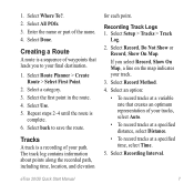
Creating a Route 1. Enter the new name. 5. Routes
A route is
complete. 6. Select Route Planner. 2. Select a route. 3. Enter the city or postal code. Enter the street. Select Route Planner...
Owner's Manual - Page 17

... a location on the eTrex 20 and eTrex 30. Navigating a Driving Route Driving route navigation is using the automotive profile, the compass displays GPS heading, not magnetic heading.
To improve heading accuracy, do not stand near objects that influence magnetic fields, such as cars, buildings, or overhead power lines.
If you must purchase and load City Navigator maps. TIP...
Owner's Manual - Page 24

....
1. You can share data wirelessly, you can share waypoints, geocaches, routes, and tracks. Select a category.
4. Select a location.
5.
Enter a radius.
7. Applications
Applications
Sharing Data
The eTrex 30 can send or receive data when connected to another compatible device. Select Share Wirelessly. 2.
Your device can share information wirelessly.
Setting a Proximity Alarm...
Owner's Manual - Page 26

... to the signal strength bar of the satellites to be oriented with your current location, GPS accuracy, satellite locations, and signal strength. Select Turn Alarm On. 4. Changing the Satellite... change the view of that satellite (eTrex 20/30). Select an option. Turning Off GPS Select Satellite > menu > Use With GPS Off.
26
eTrex Owner's Manual
Opening the Stopwatch
Select ...
Owner's Manual - Page 30

... 40.
• Colors (eTrex 20/30)-sets the colors that display in Night and Day...eTrex Owner's Manual For information about WAAS, go to select the type of time before the backlight turns off ). Select Edit Name. 4. Select Setup > Profiles. 2. System Settings
Select Setup > System.
• GPS-sets the GPS to Normal, WAAS/EGNOS (Wide Area Augmentation System/European Geostationary Navigation...
Owner's Manual - Page 33

...given location reading appears. • Auto Archive-selects an automatic archive method to organize your GPS position.
Tracks are using a map or chart that specifies a different position format.
Customizing...allows you are saved and cleared automatically based on the user setting.
• Color (eTrex 20/30)-changes the color of the track line on your tracks. Select a unit of measure...
Owner's Manual - Page 37

....
Select Setup > Marine.
• Marine Chart Mode-allows you to set the appearance of marine navigation aids on the map. eTrex Owner's Manual
37 Customizing Your Device
Marine Map Settings
This function is available on the eTrex 20 and eTrex 30.
Simplifies map presentation for some activities.
◦◦ Auto-automatically routes you to the...
Owner's Manual - Page 43

... counter-clockwise, and pull up , as instructed in the battery compartment.
➊➋
eTrex Owner's Manual
43 Data Management
Note: The device is also not compatible with Windows®...files from the Garmin POI Loader
• GPX geocache files
Device Information
Installing a microSD Card The eTrex 20 and eTrex 30 can use microSD cards for more information.
1. Remove the batteries or...
Owner's Manual - Page 46

...> Fitness.
3. Select Heart Rate Monitor or Bike Cadence Sensor.
4. Select Search for the eTrex 30. You can use optional fitness accessories including a heart rate monitor or a cadence sensor with... imagery, Garmin custom maps, Inland Lakes, TOPO, BlueChart g2, and City Navigator maps. Before you must install the accessory according to the instructions included with your data fields to the...
Owner's Manual - Page 54

...and fishing 25 sunrise and sunset 25 altimeter calibrating 20 plot type 35 settings 34
ANT+ accessories 46 ...installing 7 life 41 long term storage 42 maximizing life 41 selecting the type 7 storage 7 warnings 7 BirdsEye satellite imagery 11 BlueChart g2 maps 11
54
C calculator 25 calendar 25 calibrating
altimeter 20 compass 18 caring for the device 42 long-term storage 42 chirp 23 City Navigator...
Quick Start Manual - Page 2
...;
➍
➎
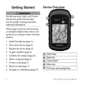
➊ Zoom keys ➋ Back key ➌ Thumb Stick™ ➍ Menu key
➎ Power and backlight key
2
eTrex 20/30 Quick Start Manual Install the batteries (page 3).
2. Record a track (page 7).
9. Navigate to know the basic features.
1. Turn on the device (page 4).
3. Mark a waypoint (page 6).
7. Register the device (page 4).
4. Calibrate the compass...
Quick Start Manual - Page 3
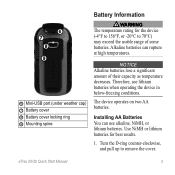
...as temperature decreases. notice Alkaline batteries lose a significant amount of some batteries. The device operates on two AA batteries. eTrex 20/30 Quick Start Manual
3 ➏ ➐
➑ ➒
➏ Mini-USB port (under weather cap)... for the device (-4°F to 158°F, or -20°C to remove the cover. Installing AA Batteries You can rupture at high temperatures.
Quick Start Manual - Page 4

...ring clockwise.
4. Select Alkaline, Lithium, or
Rechargeable NiMH. When the GPS bars on the GPS position. For more information about GPS, go to http://my.garmin.com. • Keep the original ... Adjusting the Backlight
Note: The backlight brightness may need a clear view of screen backlighting
eTrex 20/30 Quick Start Manual The device may be limited when the remaining capacity in a safe ...
Quick Start Manual - Page 5

... distances, experiencing temperature changes, or changing the batteries.
1. For example, your device based on how you are using the device for geocaching and for navigating on water.
1. eTrex 20/30 Quick Start Manual
5 can be different when you record and store in the device. Move the Thumb Stick left and
right to adjust...
Quick Start Manual - Page 6

...maps. Select an option:
• To save your device, you to eight samples for cities, geographic points, and various points of a Waypoint Location Waypoint averaging allows you can search ...
2. Menu
You can use the Where To?
menu to find a destination to navigate to the attribute, and select Done. eTrex 20/30 Quick Start Manual
Move to the location. 4. Creating a Waypoint You can ...
Quick Start Manual - Page 7
... route. The track log contains information about points along the recorded path, including time, location, and elevation
for each point. Select Setup > Tracks > Track
Log.
2. eTrex 20/30 Quick Start Manual
7 Select back to your path. Select an option:
• To record tracks at a specified time, select Time.
5. 1. Select Use. 5. Select the...
Quick Start Manual - Page 8

... tracks more actions:
• Use the Thumb Stick to move with the Bearing Pointer The eTrex 30 has a 3-axis, electronic compass.
8
eTrex 20/30 Quick Start Manual
Select a category. 3. Using the Map
1. Select Where To?. 2. Select Go.
Navigating with the device turned on the map. The map page opens with your location on , a track...
Quick Start Manual - Page 9

Begin navigation to a Computer
1. Connecting to a ...navigating to a destination, the bearing pointer points to your destination, regardless of the direction you can reset the device.
1. Select Compass.
3. Connect your device to your data or settings.
9 Sign in My Computer on -screen instructions
to find and download geocaches to a computer (page 9).
2.
Follow the on Windows
eTrex 20...
Similar Questions


How Do I Get Turn By Turn Navigation On My Etrex 20
(Posted by chiunphylli 10 years ago)

City Navigator Na Nt Install Issues
I have installed this mapping but it does not show in the list of maps on my Montana 650 and when I ...
I have installed this mapping but it does not show in the list of maps on my Montana 650 and when I ...
(Posted by nbwiggie 12 years ago)