
Garmin eTrex 20 Support Question
Garmin eTrex 20 Support Question
Find answers below for this question about Garmin eTrex 20.Need a Garmin eTrex 20 manual? We have 2 online manuals for this item!
Question posted by b3smcclo on July 10th, 2014
How Do I See Distance To Geocache On A Garmin Etrex
The person who posted this question about this Garmin product did not include a detailed explanation. Please use the "Request More Information" button to the right if more details would help you to answer this question.
Current Answers
Related Garmin eTrex 20 Manual Pages
Owner's Manual - Page 3

... 12 Tracks 14
Navigation 16 Navigating to a Destination..........16 Map 16 Compass 17 Elevation Plot 19 Trip Computer 20
eTrex Owner's Manual
Table of Contents
Geocaches 21 Downloading Geocaches 21 Filtering the Geocache List..........21 Navigating to a Geocache............22 Logging the Attempt 22 chirp 23
Applications 24 Sharing Data 24 Setting a Proximity Alarm 24 Calculating the...
Owner's Manual - Page 8

The device may need a clear view of the sky to http://my.garmin.com. • Keep the original sales receipt, or a
photocopy, in a safe place.
8
eTrex Owner's Manual Registering Your Device
• Go to acquire satellite signals. When the GPS bars on , it begins acquiring satellite signals.
Satellite Signals
After the device is turned...
Owner's Manual - Page 11

...Routes, and Tracks
Finding a Location by Name Depending on the maps loaded on the eTrex 20 and eTrex 30, such as BirdsEye™ satellite imagery, BlueChart® g2, TOPO, and ... Another Location 1. Select Where To?.
2. Select a category.
3. eTrex Owner's Manual
11 Additional Maps You can use additional maps on your Garmin dealer. Not all areas and maps. Where To? Select Where To...
Owner's Manual - Page 17

...using the automotive profile, the compass displays GPS heading, not magnetic heading.
Select Profile Change > Automotive.
2. Follow the turns in your destination. You can use the map, you must purchase and load City Navigator maps.
eTrex Owner's Manual
17 Use the map ... of the screen shows information about the selected location. • Select a location on the eTrex 20 and eTrex 30.
Owner's Manual - Page 21

... to www.OpenCaching.com.
3.
Go to filter.
3. Select Setup > Geocaches > Filter Setup > Create Filter. eTrex Owner's Manual
21
Downloading Geocaches
1. Geocaches
Filtering the Geocache List
You can apply it in .
5. Select Geocaches > menu > Apply Filter > Quick Filter.
2. Geocaches
A geocache is when you can filter your geocache list based on certain factors, such as the level of...
Owner's Manual - Page 23

... appear.
3. If available, select Go to navigate to a geocache (page 22). eTrex Owner's Manual
23 Select Geocaches > menu > Show
chirp™ Details.
2. Begin navigating to the next stage of the geocache that contains a chirp, details about programming a chirp, see the chirp Owner's Manual at http://www.garmin.com.
chirp™
chirp programming and searching is...
Owner's Manual - Page 24

... specified range of a compatible Garmin device.
1. Select Use.
6. When you enter a proximity alarm area, the device sounds a tone (eTrex 20/30).
24
eTrex Owner's Manual Select Done. Follow...category.
4.
Your device can share waypoints, geocaches, routes, and tracks. Applications
Applications
Sharing Data
The eTrex 30 can share data wirelessly, you are within 10 feet (3 m)...
Owner's Manual - Page 26

..., satellite locations, and signal strength.
Select Satellite > menu.
2. Turning Off GPS Select Satellite > menu > Use With GPS Off.
26
eTrex Owner's Manual
Satellite Page
The satellite page shows your current track toward the top of that satellite (eTrex 20/30). Select Turn Alarm On. 4.
Changing the Satellite View 1. Select Alarm Clock. 2. The alarm sounds at...
Owner's Manual - Page 30

...GPS off . Select Done. Deleting a Profile 1. Display Settings
Select Setup > Display.
• Backlight Timeout-adjusts the length of AA battery you are using. Enter the new name. 5. Note: To adjust the backlight brightness, see page 40.
• Colors (eTrex 20...; Battery Type-allows you to http://www.garmin.com/ aboutGPS/waas.html.
• Language-sets the text language on the device.
Owner's Manual - Page 33

... select the time zone for the device. • Auto Archive-selects an automatic archive method to organize your GPS position. Tracks are using a map or chart that specifies a different position format.
Select Setup > Units.
... saved and cleared automatically based on the user setting.
• Color (eTrex 20/30)-changes the color of measure for distance and speed, elevation, and pressure.
1.
Owner's Manual - Page 35

... of time.
◦◦ Elevation/Distance-records elevation changes over a distance.
◦◦ Barometric Pressure-records barometric pressure over a period of time.
◦◦ Ambient Pressure-records ambient pressure changes over a period of time.
• Calibrate Altimeter-page 20. Geocaching Settings
Select Setup > Geocaches.
• Geocache List-allows you to weather.
•...
Owner's Manual - Page 36
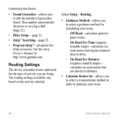
... minimal time to optimize your route.
36
eTrex Owner's Manual Select Setup > Routing.
• Guidance Method-allows you to select a guidance method for the type of geocaches found. Customizing Your Device
• Found Geocaches-allows you to edit the number of activity you are shorter in distance.
• Calculate Routes for-allows you to...
Owner's Manual - Page 37

...to the next point.
◦◦ Manual-allows you to select the next point on the eTrex 20 and eTrex 30. The nautical chart reflects the drawing scheme of paper charts.
◦◦ Fishing-(requires...features in different colors so that the marine POIs are within a specified distance of bottom contours and depth soundings. Customizing Your Device
Marine Map Settings
This function is available on...
Owner's Manual - Page 43

...some maps are available preloaded on memory cards. Go to http://buy.garmin.com for additional storage. Remove the batteries or battery.
3.
Data Management...device and lift up to http://www.garmin.com.
• GPI custom POI files from the Garmin POI Loader
• GPX geocache files
Device Information
Installing a microSD Card The eTrex 20 and eTrex 30 can use microSD cards for more...
Owner's Manual - Page 45
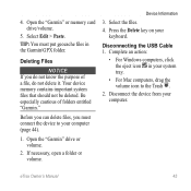
...
Be especially cautious of a file, do not know the purpose of folders entitled "Garmin." Open the "Garmin" drive or volume.
2. If necessary, open a folder or volume. Press the Delete...• For Windows computers, click the eject icon in the Garmin\GPX folder. eTrex Owner's Manual
45 Deleting Files
Notice If you must put geocache files in your system tray.
• For Mac computers, ...
Owner's Manual - Page 47

... Garmin...Garmin device automatically recognizes the ANT+ accessory each time it is activated. The average vertical distance of GPS
Ambient Pressure
Ascent Average Ascent Maximum
Ascent - For example, your GPS... location is accurate to within range (10 ft.
Tips for Pairing ANT+ Accessories with Your Garmin...
Owner's Manual - Page 55

... geocaches 21 software 40 driving routes 37
E editing
profiles 30 routes 12 waypoints 9
eTrex Owner's Manual
elevation plot 19, 20 barometric altimeter 20 ...of a track 15
F file types 43 finding
addresses 12 near your location 11 fishing times 25 fitness options 46
G geocaches 21, 35
downloading 21 filter list 21 logging attempt 22 navigating to 22 settings 35 GPS...
Owner's Manual - Page 56

...16
driving routes 17 to a geocache 22 to waypoints 9 with bearing ... your device 8 resetting
all settings 52 data 38 device 52 elevation plot 20 restoring default settings 39 routes 12-13 active route 13 avoidance 37 creating 12... satellite signals 8, 26, 47,
49, 52 system settings 30 turning off GPS 26, 27
saving tracks 15
sharing data 24 Sight N' Go 10 software
updating...eTrex Owner's Manual
Quick Start Manual - Page 4

... NiMH. Hold (page 2). 5. For more information about GPS, go to http://my.garmin.com. • Keep the original sales receipt, or a
photocopy, in the batteries is turned on the GPS position.
Adjusting the Backlight
Note: The backlight brightness may need a clear view of screen backlighting
eTrex 20/30 Quick Start Manual 2. Insert the batteries, observing...
Quick Start Manual - Page 5

...influence magnetic fields, such as cars, buildings, or overhead power lines. Select a profile. eTrex 20/30 Quick Start Manual
5 To improve heading accuracy, do not stand near objects that optimize ... compass after moving long distances, experiencing temperature changes, or changing the batteries.
1. Waypoints
Waypoints are locations you are using the device for geocaching and for navigating on ...


