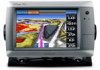
Garmin GPSMAP 740/740s Support Question
Garmin GPSMAP 740/740s Support Question
Find answers below for this question about Garmin GPSMAP 740/740s.Need a Garmin GPSMAP 740/740s manual? We have 7 online manuals for this item!
Question posted by hvbaker on August 5th, 2011
Opposite Tack
Nothing shows up in the opposite tack box when the wind sensor page is displayed. All other boxes are populated.
Current Answers
Related Garmin GPSMAP 740/740s Manual Pages
Technical Reference for Garmin NMEA 2000 Products - Page 3
...GPSMAP® 4000/5000/6000/7000 Series chartplotters ◦ GPSMAP 700 Series chartplotters ◦ GPSMAP 4x1/5x1/5x6 Series chartplotters ◦ GMI™ 10 ◦ GPS...Garmin NMEA 2000-certified displays and sensors.
• The...sensors provide the particular data type you want.
• The last two sections provide Parameter Group Number (PGN) information for Garmin chartplotters and marine...
Technical Reference for Garmin NMEA 2000 Products - Page 4
... 2000-Certified Display Device PGN Information...13
NMEA 2000-Certified Sensor PGN Information...18 GPS 17x (GPS Antenna)...18 GFS 10 (Garmin Fuel Sensor)...18 GRA 10...Wind Sensor)...20 GHP 10 (Marine Autopilot System)...20 GXM 51...21 VHF 200...21 VHF 300...21 AIS 300...22 AIS 600...22
NMEA 2000-Certified Sensor Configuration Information...23 GPS 17x (GPS Antenna)...23 GFS 10 (Garmin Fuel Sensor...
Technical Reference for Garmin NMEA 2000 Products - Page 14
..., a less-accurate reading can be calculated using only the Wind Sensor and GPS antenna [130306 - Wind Data, 127250 - Water Speed])
Either:
• Wind Sensor, a Water Speed Sensor, a Heading Sensor, and a GPS Antenna
• Wind Sensor and a GPS Antenna • Wind Sensor, a Water Speed
Sensor, and a Heading Sensor
(Continued)
10
Technical Reference for Garmin NMEA 2000 Products...
Technical Reference for Garmin NMEA 2000 Products - Page 15
... a Wind Sensor and both Water Speed and Heading Sensors, or a Wind Sensor and a GPS Antenna
Technical Reference for Garmin NMEA 2000 Products 11 Wind Data
Wind Sensor
Apparent Wind Angle
130306 - COG/SOG and 129029 - COG/SOG and 129029 - GNSS Position])
Either a Wind Sensor, a Heading Sensor, and Speed Sensor or a Wind Sensor, a Heading Sensor, and a GPS Antenna
Opposite Tack...
Technical Reference for Garmin NMEA 2000 Products - Page 41
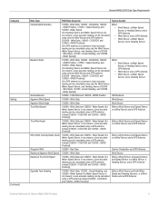
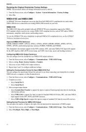
... to move or change in the wind angle. To configure the wind angle offset if the menu option is not displayed: 1. Enter the following command: "ANGLEOFFSET=" 3. A lower filter setting shows changes in increments of software loaded on your Garmin marine instrument, the specific configuration options may stabilize the display.
To configure the wind speed filter: 1. Select Generic...
Installation Instructions - Page 1
... a clear, glare-free view of the display and easy operation of two methods. For future...GPS antenna (page 6). • Connecting the chartplotter to a Garmin marine radar (page 6). • Connecting the chartplotter to www.garmin.com/support and click Contact Support for your GPSMAP 700 series chartplotter, confirm that the chartplotter software is located on a sticker on the opposite...
Installation Instructions - Page 2
... the cables and into fiberglass and overtightened.
Extend 6-7 in step 3.
8. Apply marine sealant (optional).
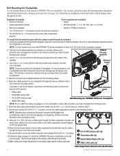
➊ GA 30 GPS antenna cable clip ➋ Power/data cable clip ➌ Garmin Marine Radar cable clip ➍ NMEA 2000 cable clip
Cable-Organization-Bracket Clip Identification
GPSMAP 700 Series Installation Instructions Bail Mounting the Chartplotter Use the included...
Installation Instructions - Page 6
... local Garmin dealer.
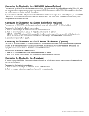
The document is not compatible with the antenna. 2. Connecting the Chartplotter to a Garmin Marine Radar (Optional)
You can connect the GPSMAP 700 series chartplotter to a GA 30 Remote GPS Antenna (Optional)
The GPSMAP 700 series chartplotter has an internal GPS receiver, but it to a transducer: 1. To connect the chartplotter to the external...
Owner's Manual - Page 3
...Safety and Product Information guide in the text indicate that item on or off.
GPSMAP 700 Series Owner's Manual
i This manual includes information for product warnings and ... finger to select it.
Small arrows (>) in the product box for the following products:
• GPSMAP® 720/720s • GPSMAP 740/740s • GPSMAP 750/750s
Tips and Shortcuts
• Select Home from any...
Owner's Manual - Page 4
...Chartplotter 1 Initial Chartplotter Settings 2 GPS Satellite Signal Acquisition 2 Adjusting the...Mariner's Eye 3D 17 Fish Eye 3D 18 Fishing Chart 19 Showing...To 33 Marine Services Destinations...44 Display ...Display Modes 55 Waypoints and Routes on the Radar Screen...60 About the Radar Overlay 61 Optimizing the Radar Display 62 Radar Display Appearance 66 Radar Overlay Display...Display...Viewing GPS ...
Owner's Manual - Page 12
...and tide station indicators.
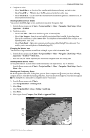
• Select Animated to use GPS heading data. Select the name of the navaid (or Review...Perspective 3D, or Mariner's Eye 3D. 3. An option describing the navaid appears, such as magnetic heading) or to show and configure tide ...from a heading sensor
(also known as Beacon or Light. 4. Select Navigation Chart Setup or Fishing Chart Setup.
8
GPSMAP 700 Series Owner...
Owner's Manual - Page 15
... your boat, indicating compass direction oriented to the heading of interest (POIs). • Select Light Sectors to a compatible marine wind sensor.
1. True wind direction or apparent wind direction appears ➋ if the chartplotter is visible. Select Roses. 6. Showing Additional Chart Details You can select a large, medium, or small boat or triangle as your vehicle icon on...
Owner's Manual - Page 18
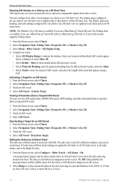
... or Mariner's Eye 3D. 3. Touch the AIS vessel. 4. The object is still labeled as dangerous on the screen.
2. Select a distance or select Show All.
• Select Details > Show to show details about...and to the Radar Overlay.
1. Complete an action:
• Select AIS Display Range to 2.0 mi.).
14
GPSMAP 700 Series Owner's Manual Select AIS Vessel. From the Home screen, select ...
Owner's Manual - Page 20
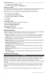
... information on BlueChart g2 Vision-compatible Garmin GPS units or Garmin HomePort™.
Select Perspective 3D or Mariner's Eye 3D. 3. Select Done.
Showing and Configuring Data Overlay See "Overlay Numbers... should ground yourself on or off.
16
GPSMAP 700 Series Owner's Manual Charts and 3D Chart Views
2.
The BlueChart g2 Vision Mariner's Eye 3D is available with enhanced bottom ...
Owner's Manual - Page 45

...on a stationary boat. air experienced while on the flow of A wind sensor.
From the Home screen, select Information > Dashboard Gauges > Wind > Menu. 2. GPSMAP 700 Series Owner's Manual
41 Environmental Data
Wind Gauges Viewing Wind Gauges
From the Home screen, select Information > Dashboard Gauges > Wind. True Wind
Shows wind speed data based on a boat in motion.
From the Home screen...
Owner's Manual - Page 46

... the downwind close hauled wind gauge appears.
42
GPSMAP 700 Series Owner's Manual Configuring the Wind Speed Source You can specify whether the vessel speed data displayed on the compass is calculated from your GPS position.
1. Water speed is the speed reading from a water-speed sensor, and GPS speed is based on the wind gauge. From the Home...
Owner's Manual - Page 54

... message, contact Garmin Product Support.
50
GPSMAP 700 Series Owner's Manual Device Configuration
4. NOTE: If the boat is not moving fast enough or the speed sensor is available if you can show the tracks of DSC vessels, and select the length of Other Vessels Note: The Mariner's Eye 3D chart is not stuck. Using...
Owner's Manual - Page 75
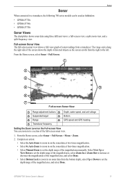
...right side of the screen shows the depth of detected objects as fishfinders: • GPSMAP 720s • GPSMAP 740s • GPSMAP 750s
Sonar Views
The chartplotter shows sonar data using three different... and unit voltage
➌ Suspended target
➍ Bottom
➎ Range
➏ GPS speed and GPS heading
➐ Transducer frequency
Setting the Zoom Level on the sonar data at two...
Owner's Manual - Page 90
... Data Transfer to wire various NMEA 0183-compliant devices, such as VHF radios, NMEA instruments, autopilots, wind sensors, and heading sensors. Setting Decimal Precision for transmission of NMEA output.
1. Select Two Digits, Three Digits, or Four Digits.
86
GPSMAP 700 Series Owner's Manual Select one or more NMEA 0183 output sentences. 4. NMEA 0183 The...
Owner's Manual - Page 94
... water 77 fish 77 GPS accuracy 52 navigation 51 ... speed 68 size 68 apparent wind 41 arrival alarm 51 Auto Guidance...sensor 1 back panel 1 barometer 43 basemap version 3 blend, photo map 20
90
BlueChart g2 Vision aerial photos 11 chart symbols 5 data cards 16 Fish Eye 3D 18 Mariner's Eye 3D 17 POIs 21
bridging, output 88 brightness, display... 79
E EBL
measuring 59 showing 59 EGNOS 85 engine gauges ...
Similar Questions

How Do I Go Into Simulation Mode On A Garmin Marine Gps Modle741xs
how do I use simulation mode on a garmin 741xs marine ver
how do I use simulation mode on a garmin 741xs marine ver
(Posted by Curthupp 7 years ago)

How Do I Do An Automatic Boat Route? Have Garmin 740s Gpsmap With G2 Vision Card
(Posted by Anonymous-115411 10 years ago)

541s Marine Gps. Depth Not Reading Out.
Depth has been working since installed. Now blank. Is there an on off control for this that may have...
Depth has been working since installed. Now blank. Is there an on off control for this that may have...
(Posted by therad50 11 years ago)
