Garmin GPSMAP 740/740s Support Question
Garmin GPSMAP 740/740s Support Question
Find answers below for this question about Garmin GPSMAP 740/740s.Need a Garmin GPSMAP 740/740s manual? We have 7 online manuals for this item!
Question posted by Anonymous-115933 on July 12th, 2013
My Garmin 740s Keeps Telling Me It Can't Calculate Auto Routes
The person who posted this question about this Garmin product did not include a detailed explanation. Please use the "Request More Information" button to the right if more details would help you to answer this question.
Current Answers
Related Garmin GPSMAP 740/740s Manual Pages
Technical Reference for Garmin NMEA 2000 Products - Page 9

... the farthest device, in meters) × Network Load** × 0.1
* Garmin cable resistance value = 0.053 ** Network Load = the sum of Load Equivalent Numbers... 7) × 0.1 = 2.37 Vdc
Cable
Distance
Network load
resistance
Technical Reference for the device.
• If you calculate a voltage drop of 3.0 Vdc or less, then you must be visible on both sides of the power connection.
•...
Technical Reference for Garmin NMEA 2000 Products - Page 10
... × (2 + 10 + 6) × (5 + 7) × 0.1 = 1.145 Vdc
Note: The equation and examples provide conservative estimates for calculating voltage drop.
Technical Reference for both directions.
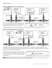
NMEA 2000-
If the T-connector to both the left and right Voltage Drop Left = 0.053 ×... power source in order to the center of the calculation for Garmin NMEA 2000 Products
Technical Reference for Garmin NMEA 2000 Products - Page 12
...mini connectors and cables in the product documentation.
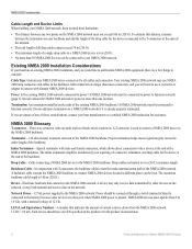
Technical Reference for Garmin NMEA 2000 Products If you would like to add Garmin NMEA 2000 equipment, there are limited to 6 m (20 ft.)... directly connected to the battery) because some devices are always on your NMEA 2000 network, keep in different places on the ends of the backbone. NMEA 2000 Fundamentals
Cable Length and Device...
Technical Reference for Garmin NMEA 2000 Products - Page 13
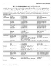
Refer to the following table for Garmin NMEA 2000 Products
Eng Dynamic 127489 - Eng Dynamic 127489 - Small Craft Status 127489 - Fluid Level 127505 - GNSS Position, 129284 - COG/SOG, 129029 - Route 129284 - Route 129284 - Nav Data 129283 - Vessel Heading 129026 - specific NMEA 2000 PGN information required to view or calculate that typically provides required PGN information...
Installation Instructions - Page 1
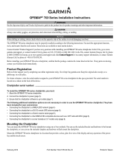
... chartplotter to a NMEA 2000 network (page 6) • Connecting the chartplotter to a GA 30 remote GPS antenna (page 6). • Connecting the chartplotter to a Garmin marine radar (page 6). • Connecting the chartplotter to www. Mounting the Chartplotter
You can use the GPSMAP 700 series chartplotter.
In Europe, go to other important information.
Caution Always wear...
Installation Instructions - Page 6
... a transducer: 1. Route the Garmin marine network cable to the external GPS antenna connector. Update the chartplotter software (page 7). If you have one installed on your local Garmin dealer. Connecting the Chartplotter to provide GPS information. You can install a GA 30 remote GPS antenna (not included) in the product name), you do not have a sonar-cable GPSMAP 700 series...
Owner's Manual - Page 4
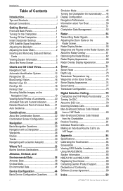
... 1 Initial Chartplotter Settings 2 GPS Satellite Signal Acquisition 2 Adjusting ...g2 Vision 16 Mariner's Eye 3D...Auto Guidance 21
Combinations 22 About the Combination Screen 22 Combination Screen Configuration 22
Navigation 25 Basic Navigation Questions 25 Navigation with a Chartplotter 25 Waypoints 26 Routes 28 Tracks 30 Navigating with a Garmin Autopilot 32
Where To 33 Marine...Routes...
Owner's Manual - Page 6
...routes, and tracks to view high-resolution satellite imagery and aerial reference photos of ports, harbors, marinas, and other points of interest. Follow the on-screen directions to www.garmin.com/aboutGPS.
For more information about GPS, go to configure the initial settings.
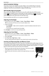
Select Day Colors, Night Colors, or Auto...eject the card.
➊
2
GPSMAP 700 Series Owner's Manual
From ...
Owner's Manual - Page 9
...SD card, or if your path.
GPSMAP 700 Series Owner's Manual
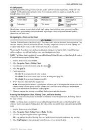
5 That data does...Icon Description Current station
Information
Icon Description Marine services
Tide station
Icon Description
Overhead photo...to the location. • Select Route To to create a route to the location, including turns (...Auto Guidance cannot calculate part of the map, the screen scrolls forward to ...
Owner's Manual - Page 20
...not using the card, keep it away from the ...Auto Guidance (page 21)-uses specified safe depth, safe height, and chart data to determine the best course to the card.
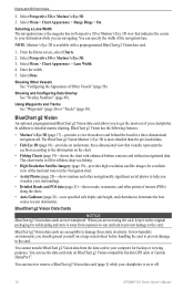
Note: Mariner...Vision-compatible Garmin GPS units or Garmin HomePort™...Mariner's Eye 3D. 3. BlueChart g2 Vision
An optional, preprogrammed BlueChart g2 Vision data card allows you should ground yourself on or off.
16
GPSMAP...
Owner's Manual - Page 30
...Route Using Route To See "Browsing for this option to 3,000 waypoints with your present location to the destination. Carefully compare the course to all visual sightings and avoid any land, shallow water, or other obstacles that may pass over land or shallow water. This is a thinner purple line that Auto Guidance cannot calculate... or Fishing Chart.
26
GPSMAP 700 Series Owner's Manual
Owner's Manual - Page 37
..., and other obstacles that Auto Guidance cannot calculate part of destinations offering marine services. Where To? Navigating to navigate. When using Auto Guidance, a gray line within...Auto Guidance.
5.
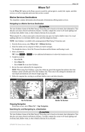
Where To?
Complete an action:
• Select Go To.
• Select Route To.
• Select Guide To to show the location on electronic chart information. Note: Auto...
Owner's Manual - Page 38

... routes, saved tracks, and marine ...Routes. 2.
When using Auto Guidance, a gray line within any part of the magenta line indicates that contain your path.
The 50 nearest destinations that Auto Guidance cannot calculate...route (page 29).
1. Select Navigate To.
34
GPSMAP 700 Series Owner's Manual Select a waypoint. 3. Select a route. 3.
You can browse a list of routes...
Owner's Manual - Page 46

... the Wind Speed Source You can specify the range of the close hauled wind gauge appears.
42
GPSMAP 700 Series Owner's Manual Water speed is the speed reading from a water-speed sensor, and GPS speed is calculated from a
water speed sensor. Almanac, On-boat, and Environmental Data
Configuring the VMG Source You can...
Owner's Manual - Page 49
... touched and when
alarms are triggered (default). • Select On (Touch and Alarms) to calculate fuel economy comes from your GPS position.
1. Auto Guidance Line Configurations You can set how much time, or how far, before a turn in a route that is available with many frequent turns, or at higher speeds. From the Home screen...
Owner's Manual - Page 51
... calculating heading information.
1. Configuring the Time 1. Proceed to step 11. • If the Auto ... a time-keeping standard, and select 12 Hour, 24 Hour, or UTC (universal time coordinate).
• Select Time Zone > Auto Time Zone...Auto Guidance > Shoreline Distance > Farthest. • If the turns in the Auto Guidance line are too wide, from obstacles in which the map is WGS 84.
GPSMAP...
Owner's Manual - Page 54

... Home screen, select Configure > System > GPS. 2.
Configuring the Appearance of Other Vessels Note: The Mariner's Eye 3D chart is available if you... Display Setup to get the message, contact Garmin Product Support.
50
GPSMAP 700 Series Owner's Manual NOTE: If the...to keep the speed filter on continuously, enter the speed filter time duration and select Done.
• Select Speed Filter > Auto to...
Owner's Manual - Page 93
... FOLLOWING SOFTWARE LICENSE AGREEMENT.
and its subsidiaries ("Garmin") grant you by completing our online registration today:
• Go to http://my.garmin.com. • Keep the original sales receipt, or a photocopy, ...States of America or the export control laws of Conformity, go to www.garmin.com/compliance. GPSMAP 700 Series Owner's Manual
89
You agree not to export or re-...
Quick Reference Guide - Page 1
...all visual sightings and avoid any part of the magenta line indicates that Auto Guidance cannot calculate part of the Bluechart g2 Vision data card is closest to your boat....To Screen
Guide To Screen
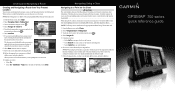
GPSMAP® 700 series
quick reference guide Creating and Navigating a Route
Creating and Navigating a Route from Your Present Location
You can choose to save the route.
11.Complete an action...
Quick Reference Guide - Page 2

... want to www.garmin.com for product warnings and other obstacles that Auto Guidance cannot calculate part of the ..., select Man Overboard. Select a destination. Garmin®, the Gamin logo, GPSMAP®, BlueChart®, and g2 Vision®...• Select Route To.
• Select Guide To to a Marine Services Destination
CAUTION The Auto Guidance feature of Garmin Ltd. Review...
Similar Questions

How Do I Go Into Simulation Mode On A Garmin Marine Gps Modle741xs
how do I use simulation mode on a garmin 741xs marine ver
how do I use simulation mode on a garmin 741xs marine ver
(Posted by Curthupp 7 years ago)


How Do I Do An Automatic Boat Route? Have Garmin 740s Gpsmap With G2 Vision Card
(Posted by Anonymous-115411 10 years ago)

541s Marine Gps. Depth Not Reading Out.
Depth has been working since installed. Now blank. Is there an on off control for this that may have...
Depth has been working since installed. Now blank. Is there an on off control for this that may have...
(Posted by therad50 11 years ago)